Overnight, the National Hurricane Center (NHC) increased the chances of tropical cyclone formation for Invest 94L to 60% in the next five days. Yesterday, NHC estimated 20%. “Invest” stands for Area of Investigation.
Reasons for Increased Chance of Formation
According to Harris County Meteorologist Jeff Lindner, “The tropical wave located over the far eastern Atlantic is fairly disorganized this morning with scattered areas of deep convection. The wave is moving westward and this motion will continue for the next 5-7 days.”
If you looked only at climate history for this time of year, says Lindner, you would not give this disturbance much of a chance to intensify into a tropical cyclone.
However, low wind shear, modest forward motion, and available moisture in the wave all support some degree of development in the next few days.
Storm Track Forecasts
Most models show development as the wave nears or reaches the eastern Caribbean Islands. European and Global forecast models tightly align with a track through the extreme southern Caribbean Sea. Meanwhile, the Canadian model shows the storm tracking farther north at a higher intensity.
Virtually all models indicate similar tracks until the system reaches the central Caribbean Sea.
Lindner believes the southern track is most likely given the time of year. He also sees potential for intensification due to favorable atmospheric conditions along the path. The satellite photo below shows the current extent of the disturbance.
94L is in lower right.
The National Hurricane Center says, “A tropical depression could form during the early to middle part of next week while it moves westward at around 15 mph over the tropical Atlantic and approaches the Windward Islands.”
If you like viewing satellite images and animations from a wide variety of sources, I highly recommend the following sites:
https://i0.wp.com/reduceflooding.com/wp-content/uploads/2022/06/image003-e1656082390202.png?fit=1244%2C755&ssl=17551244adminadmin2022-06-24 10:33:452022-06-24 10:33:48Chances of Formation Increase to 60% for Invest 94L
According to Harris County Meteorologist Jeff Lindner, the high pressure weather pattern that has created unprecedented temperatures since late May will finally move away early next week. That should bring decent rain chances to the region.
The mid- and upper-level ridge of high pressure over Texas will meander overhead through the weekend with highs ranging from 99-103 each day. Then, the ridge will break down and shift westward early next week. Until then, however, we will be near or at heat-advisory criteria from Friday through the weekend. Sea-breeze showers are possible today, but less likely Friday-Sunday.
Global models consistently predict that the high-pressure ridge will shift westward. That will let a frontal system slip into the region from the NE/ENE either late Sunday or early Monday.
“If you wanted cooler temperatures and some rainfall…this is one way to get it in the middle of summer.”
Jeff Lindner, Harris County meteorologist
Rainfall Chances Next Week
Gulf moisture should also increase early next week. That will bring desperately needed showers and thunderstorms as early as Sunday night and continuing into much of next week. Widespread rainfall amounts of .50-1.0 of an inch will be possible, with some locations seeing higher totals of 2-3 inches. Rainfall will likely affect much of the state.
The front should stall near the coast or even offshore at some point next week and eventually wash out.
Most of the Houston area could see up to an inch of rain next week.
Galveston Sea Surface Temps
Lindner warns that “We will have to keep an eye on the decaying boundary for any sort of low pressure area that may try to develop. No models show anything of concern at this point. But we should carefully watch any front over the very warm Gulf waters this time of year.
A strong tropical wave is moving westward into the Atlantic from Africa. The National Hurricane Center expects little development of this wave over the next 2-3 days. However, global models indicate that as this wave nears the Caribbean next week, conditions may be favorable for some development.
According to Lindner, tropical development this far east rarely happens this time of year. However, it does happen occasionally.
Tropical waves tend to struggle in this area this time of year. So development chances are only 20% right now. But no one knows yet what will happen when it reaches the Caribbean next week.
Season’s first Saharan tropical wave is moving toward the Caribbean and could arrive next week.
Pardon my rant about the phrase “historic disinvestment.” I just came out of another Harris County Community Flood Resilience Task Force meeting. Much of the conversation centered around “historic disinvestment” in low-to-moderate income (LMI) neighborhoods.
Having examined Harris County flood-mitigation spending in detail for two years now, I asked a simple question. “What is your basis for claiming historic disinvestment?”
No one had an answer. But they’re hoping to find one. In logic, they call this “begging the question.” Begging the question is a fallacy that occurs when an argument’s premise ASSUMES the truth of the conclusion.
The problem: sometimes data contradicts the premise. So let’s take a look at data. Via a Freedom of Information Act (FOIA) request, I obtained HCFCD and partner spending by watershed going back to 2000. Here’s what it looks like as of the end of the first quarter of 2022.
Four LMI Watersheds Received More Than Half of All Spending
Focus on the four watersheds at the left in the bar graph below. Together, they have received $2 billion out of $3.8 billion. That’s 53% of all flood-mitigation spending since 2000. Out of 23 watersheds!
All four have LMI majorities. Brays has 58% LMI residents. White Oak has 51%. Sims has 65%. And Greens has 57%.
Data obtained from HCFCD via FOIA Request. Valid through end of Q1 22.
Kingwood Doesn’t Get All the Money
Regardless, Precinct 1 Commissioner Rodney Ellis frequently says, “Kingwood gets all the money and poor neighborhoods get none.”
So I looked up the amount of capital improvement construction spending in Kingwood this morning. To my knowledge, in the history of the Flood Control District going back to 1937, we’ve had one capital improvement project that has gotten to the construction phase. That’s an excavation and removal contract now underway in Woodridge Village. The screen capture below shows that HCFCD has paid out $230 dollars on the $1225 contract to date.
Ellis constantly complains about this project and how hard people lobbied him to approve it. Thank you for the magnanimous gesture, Commissioner!
Hmmmm. $230 vs $2,002,838,150. That works out to about one ten-thousandth of one percent (0.00001%) for Kingwood. And the $2 billion represents justfour LMI watersheds! Add the other four and that percentage starts to look road-kill bad.
Gee, with math skills like Rodney’s, little wonder the county is in financial trouble.
But we’re comparing a subdivision to watersheds. So, to be fair, let’s look at affluent watersheds, not just affluent neighborhoods.
Four Affluent Watersheds Get One Third of Four LMI Watersheds
Since Ellis’ argument is that rich neighborhoods like Kingwood get all the flood-mitigation money, let’s look at spending in the four most affluent watersheds (those with the lowest percentages of LMI residents). That should make the most extreme test case.
Little Cypress has 16% LMI. Barker has 22%. Armand has 26%. And Cypress Creek has 26%. Spending in those four watersheds since 2000 totals $599 million out of a total $3.8 billion. That’s 15% compared to 53% for the LMI watersheds.
LMI watersheds still received more than three times the funding of the most affluent. That’s hardly historical discrimination any way you look at it.
Look Forward, Not Back
In the face of these numbers, to talk about historic disinvestment in LMI watersheds stretches credulity. Some might say it sounds downright self-serving. The Latin phrase ignorantia affectata describes what I think is causing the data denial.
I found a great description of it on this blog. “The deniers first deceive themselves that they are sincere in their adherence to falsehoods. Thus they cannot be faulted for acting on genuinely held views. But in truth, they have cultivated an ignorance of the facts, an ignorance so useful that one protects it at all costs … in order to continue using it in one’s own self interest.”
To find genuine solutions to Harris County’s flooding problems, we need to start looking forward, not back. We must focus on the real causes of flooding; not imagined ones. We must put our money where the most flood risk remains after investing nearly $4 billion in the last 22 years. But, sadly, we don’t yet know where that is.
Posted by Bob Rehak on June 22, 2022
1758 Days since Hurricane Harvey
The thoughts expressed in this post represent opinions on matters of public concern and safety. They are protected by the First Amendment of the US Constitution and the Anti-SLAPP Statute of the Great State of Texas.
https://i0.wp.com/reduceflooding.com/wp-content/uploads/2022/06/Screen-Shot-2022-06-22-at-3.39.23-PM.png?fit=1596%2C1028&ssl=110281596adminadmin2022-06-22 19:27:512022-06-22 20:00:35$230 vs. $2,000,000,000: Where’s the “Historic Disinvestment”?
Two months shy of Hurricane Harvey’s fifth anniversary, I came across a 52-page book called Hurricane Harvey: Impact and Response in Harris County. Harris County Flood Control District (HCFCD) published it in May 2018 as the final toll of the storm became clear.
Free download, still available on the HCFCD website.53 Megabytes.
An Emotional and Statistical Recreation of the Event
Unlike the statistical report put out by HCFCD on Harvey, this book is filled with poignant pictures and informative graphics that emotionally and statistically recreate the impact of the storm and our immediate response to it. (Unfortunately, virtually all images are copyrighted, so I cannot show them here.)
The foreword contains the Army Corps plea to Congress for $10 billion against the backdrop of a $20 billion economic impact from damage to Texas Ports. It also contains additional requests by the Texas Congressional delegation and senators for an additional $8.7 billion for disaster recovery funds, state educational agencies, SBA disaster loans, economic development aid, and transportation infrastructure repairs.
Book Includes…
These requests form the backdrop for the rest of the book. Various sections show:
The scope and and scale of the storm
Human impacts
Economic impacts
How the storm developed
Comparisons to other record storms
Rescue efforts
The flood history of Harris County
Damages
Lake Houston and Lake Conroe dam performance
Disaster response efforts/first responders
Statistics show the unprecedented intensity, breadth and duration of this storm which dumped the greatest amount of rain in North American history.
Watershed by Watershed Impacts
The book also highlights the storm’s impact on every watershed, damage to drainage infrastructure, the port of Houston, downtown, and how previous flood-damage-reduction projects performed.
For anyone trying to help friends, loved-ones or newcomers understand the punishment dished out by Harvey, this is a go-to resource. Beautifully written and art directed, it may bring a tear to survivors’ eyes.
The photo that got me was by Elizabeth Conley of the Houston Chronicle. It showed volunteers sorting acres of donated clothes at the George R. Brown Convention Center. Somehow, that captured the scope of the human impact like few other photos have.
Since Hurricane Harvey, I’ve continually run into several widely held misperceptions about flooding in Harris County. As we head into another hurricane season, let’s set the record straight about the most common myths. Some of the facts below have been adapted from information provided by the Harris County Flood Control District.
MYTH: The Harris County Flood Control District is responsible for addressing all types of flooding.
FACT: The Harris County Flood Control District is responsible for bayous and many of their tributaries. However, the City of Houston, other municipalities, and Precincts – in unincorporated Harris County – handle storm sewers and roadside ditches.
The Texas Department of Transportation handles drainage of highways and their feeder roads.
The moral of this story: make sure you call the right people when you see a problem developing.
MYTH: I’ve lived in my house for more than 30 years and I’ve never flooded. Therefore, I don’t need flood insurance.
FACT: Most Harris County residents live in homes vulnerable to flooding because:
Our topography is flat.
Many of us have impermeable clay soils that increase runoff.
Our subtropical climate can produce large amounts of rain in short periods of time.
Storm rainfall patterns may have spared your area since you have lived there. But that could change like the weather.
During Harvey, more than 68 percent of the homes that flooded in Harris County were outside the 100-year flood plain. So, consult your insurance agent. Most homeowner insurance policies do not cover flooding. You need a separate policy for that.
MYTH: A 1-percent (100-year) flood occurs only once every 100 years.
FACT: A 1-percent (100-year) flood can occur multiple times throughout a century. A 100-year flood has a 1-percent chance of occurring in any given location in any given year. Doesn’t sound like a lot? Think of it this way: A home in a 1-percent (100-year) floodplain has at least a 26-percent chance of flooding during a 30-year period of time – the duration of many home mortgages. And remember, Harris County experienced four hundred-year events in four years (Tax Day, Memorial Day, Harvey, and Imelda).
MYTH: I only need to worry about flooding during hurricane season.
FACT: Flooding can happen any time of the year. Of the four storms mentioned above, two occurred outside of hurricane season.
Short, high intensity rainfalls can cause street flooding that invades vehicles and homes built close to street level or near developments with insufficient mitigation.
High water rescue truck on flooded Elm Grove Street, May 2019
MYTH: If I didn’t flood during Allison or Harvey, chances are I won’t ever flood.
FACT: The greatest rainfall brought by Tropical Storm Allison hit the northeast part of Houston and Harris County, dropping more than 28 inches of rain in 12 hours and 35 inches of rain in five days. However, some areas received fewer than 5 inches of rain. Had the damaging rains of Allison targeted other areas, they would have experienced similar, devastating flooding.
Harvey also hit and missed certain areas. But the differences were even more dramatic. While Friendswood received 56″ of rain, Willis in Montgomery County received only 5″ between August 25 through September 1, 2017. See USGS, Table 1, Page 3.
MYTH: I don’t need flood insurance because I don’t live in a mapped floodplain.
FACT: We are all at risk for flooding regardless of our proximity to a mapped floodplain. Flood Insurance Rate Maps (FIRMs or floodplain maps) published by the Federal Emergency Management Agency are good indicators of flooding risks from bayous and creeks overflowing their banks. However, they do not show flooding risks from storm sewers and roadside ditches exceeding their capacity, risks from unstudied bayous and creeks, or risks from storms greater than a 0.2 percent (500-year) flood — such as Tropical Storm Allison in 2001 or Hurricane Harvey in 2017.
MYTH: New land development causes flooding.
FACT: New development can accelerate the time of concentration of floodwaters, contributing to faster, higher flood peaks. That’s why cities and counties regulate development. But some see lax regulation and enforcement as a tool to attract new development. And even those with strict regulations may find that they aren’t strict enough to handle storms of increasing intensity.
HCFCD graph showing effect of development in Brays Bayou watershed. Insufficiently mitigated development over 85 years accelerated runoff, building flood peaks faster and higher.
Regulations dating to the early 1980s in many areas require stormwater runoff after development to be no greater than runoff before development. Developers must detain any excess stormwater on site. However:
Development prior to the 1980s was not as regulated.
Our understanding of what constitutes a 100-year rainfall continues to evolve. So pre/post estimates may be off.
Loopholes exist in many jurisdictions that allow developers to avoid building detention ponds.
MYTH: A storm surge from a tropical storm or hurricane will inhibit our bayou system’s ability to drain.
FACT: Most of our bayous and creeks are upland and drain by gravity. Because of their natural slope toward Galveston Bay, a storm surge caused by a tropical storm or a hurricane will not impede this process. Of the roughly 2,500 miles of bayous and creeks in Harris County, only a small portion near Galveston Bay will be influenced by storm surge for a short period of time.
Posted by Bob Rehak on 6/20/22with thanks to the Harris County Flood Control District
1756 Days after Hurricane Harvey
https://i0.wp.com/reduceflooding.com/wp-content/uploads/2022/01/MultiBlockages.jpg?fit=1440%2C960&ssl=19601440adminadmin2022-06-20 12:44:012022-06-21 07:32:35Mythbusters: Common Misperceptions about Flooding in Harris County
Scott Elmer, P.E. CFM and Assistant Director of Operations for HCFCD, gave most of the presentation. A large part of it focused on the benefits of a flood tunnel system. The hour and twenty minute presentation contained more information than the presentation online. So, I will try to fill in some blanks for you.
Mr. Elmer talked extensively about “inherited flooding.” Much of Harris County, he says, developed before we fully understood flood risk and developed regulations to reduce it. For instance, he showed a series of three images around Halls Bayou and I-45.
#1 showed rural farmland.
#2 showed development starting near the bayou.
#3 showed development so dense that it would require buyouts before mitigation by conventional means.
Mr. Elmer then discussed the time, cost, and disruption of buying out enough properties to construct basins and widen channels. I posted about this last year in regard to the detention basins that straddle Halls at US59. Entire subdivisions had to be bought out before construction could begin. Each of those two basins took approximately a decade to finish, with most of the time consumed by buyouts.
Example of Ideal Location
Here’s an example of another location, farther up Halls between I-45 and Airline Drive.
One of the areas of heavy, repetitive flood damage in Harris County. Image from 1978. Area was farmland in the 1950s.
Many homes in this flat area are no more than a foot or two above the bayou banks. Some even sit below street level.
The entire area lies within some kind of flood hazard. And keep in mind, that this flood map was developed after Tropical Storm Allison in 2001. It does not even represent the risk under Atlas 14, the new flood probabilities developed after Harvey.
Tunnels represent an ideal complement to traditional solutions in such cases. They:
Expand options for flood damage reduction
Make the county’s stormwater network more robust
Reduce community disruption and increase resiliency
They make the most sense in areas where:
Land for traditional solutions is unavailable
Residential property acquisition would disrupt neighborhoods
Surface solutions would result in environmental impacts
Elmer presented a hypothetical situation to demonstrate equivalent risk reductions. Thirty-four acres required for tunnel construction could offset 3,145 acres of land needed for channel improvements and stormwater basins.
How Tunnel Locations Chosen
In describing how HCFCD chose the eight watersheds for further study, Elmer focused on:
Population density
Damage centers with high risk
Safety of lives
Strategic locations for intakes and outfalls
Identifying opportunities to integrate tunnels with other flood damage reduction measures
Avoiding geologic and man-made hazards, such as oil and water wells; or geologic faults.
As for the absence of tunnel recommendations on the eastern side of the county, Elmer simply said, other solutions would be more cost effective. He did not provide additional explanation.
Elmer’s presentation lasts a little more than half an hour.
A moderator describes the need for public comment before September 30 at 41:26.
Q&A begins 42:30.
The video ends at 1:18:00.
Items Not Covered
HCFCD gave no specific rationales for:
Locations of each of the eight tunnels.
Excluding large areas of the county.
I, for one, want to read the entire report before submitting my comments. But HCFCD has not made the report available online.
The presenters did not mention current flood risk in the respective locations. Nor did they say whether their recommendations accounted for recent flood mitigation investments.
Since 2000, the watersheds benefitting from the eight tunnels have already received 64 percent of all flood mitigation investments in Harris County. That includes partner spending. For instance:
Brays Bayou has received $575.3 million.
White Oak has received $526.3 million.
Sims Bayou has received $460 million.
Cypress and Little Cypress have received $442.5 million.
Greens has received $440 million.
Hunting and Halls have received $293.7 million.
Full Study Not Released
Before I vote on flood tunnels for these areas, I want to know how much flood risk remains compared to other areas that received less investment.
However, HCFCD has not yet released a study on the level of service (flood frequency likelihood) for every channel in the county.
The Phase 2 study just completed indicates we could spend $30 billion more on 132 miles of tunnels. That works out to almost a quarter billion dollars per mile.
Before I invest that much, I want to know how engineers arrived at these recommendations. Specifically, how much did politics enter into these decisions? The write up on HCFCD’s tunnel page makes it clear that “equity considerations” including the social vulnerability index weighed heavily.
I also want to know how the Cypress tunnel emptying into the San Jacinto West Fork between US59 and West Lake Houston Parkway would affect flooding in the heavily populated Humble/Kingwood Area.
Public Comment Period Lasts Through September 30
If you wish to submit public comments on the flood tunnels, you have until September 30, 2022. Submit comments at Public Input.com/tunnels. I intend to request the entire engineering study and will post more when I learn how HCFCD made the recommendations.
Posted by Bob Rehak
1755 Days since Hurricane Harvey
https://i0.wp.com/reduceflooding.com/wp-content/uploads/2022/06/Screen-Shot-2022-06-19-at-5.15.23-PM.png?fit=2452%2C1366&ssl=113662452adminadmin2022-06-19 18:41:182022-06-21 15:32:54HCFCD Recommends More Study for $30 Billion Flood Tunnels
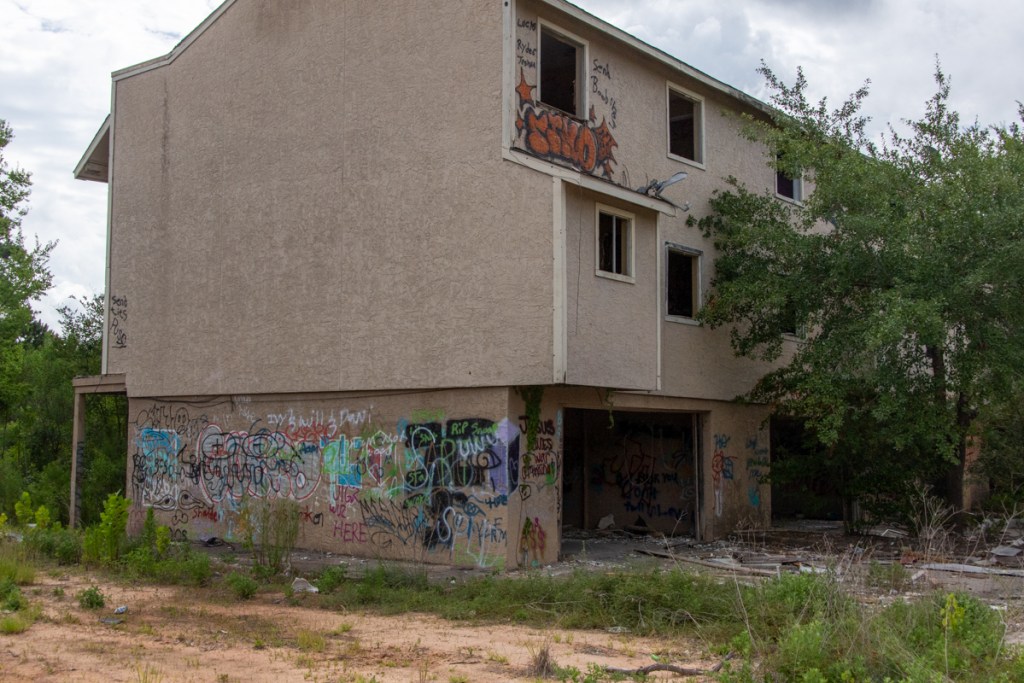
Harris County Flood Control District (HCFCD) has set the demolition dates for two of the three remaining Forest Cove Townhome complexes. The two farthest from the river will be torn down on 7/5/22 and 7/14/22. See image below.
On 6/17/22, HCFCD also deposited the check for the buyout of the last unit in the last complex. So, according to HCFCD spokesperson, Amy Stone, “The final demolition should be scheduled soon!”
Demolition dates for the three remaining Forest Cove Townhome complexes.San Jacinto West Fork at top of frame. Forest Cove Community Center and swimming pool on right.
Reason for Delays
Buying out close to 100 units destroyed by Harvey has been a tortuous and time-consuming process. Several of the owners, unable to live in the townhomes, reportedly walked away from their properties, leaving them in limbo. In the process, they created a blight on the community that became a magnet for drug dealing, illegal dumping, vandalism, arson, and graffiti.
I talked to an angry Forest Cove resident this morning who can’t wait for the last remaining units to be demolished.
Photos Taken on 6/18/22
Here are some photos taken this morning from ground and air showing the condition of the last units still standing.
Two complexes scheduled for demolition on 7/5 and 7/14.Same complexes from the ground.Last complex, not yet scheduled for demolitionSame complex from ground level.
Back to Green Space
HCFCD usually lets such buyout areas return to green space and has announced its intention to do the same here. However, it’s not yet clear exactly what that means. Flood Control has not yet responded to a request for specific plans.
Nevertheless, the Houston Parks Board has already begun a trail along the West Fork. It currently reaches from the Kingwood trail system at River Grove Park to Marina Drive in Forest Cove, shown below. It now terminates behind the two complexes already scheduled for demolition in July.
Terminus of Houston Parks Board San Jacinto Greenway at Marina Drive, approximately 2.6 miles from River Grove Park as the crow flies.
Planned route of trail connecting Woodland Hills Drive to 59 and Spring Creek Trail.Green = completed. Purple = planned.
Someday soon, this area could become a huge asset to the Kingwood/Forest Cove/Lakewood Cove community again.
Posted by Bob Rehak on 6/18/22
1754 Days since Hurricane Harvey
https://i0.wp.com/reduceflooding.com/wp-content/uploads/2022/06/20220618-RJR_9535.jpg?fit=1200%2C800&ssl=18001200adminadmin2022-06-18 12:34:142022-06-18 12:49:50Demolition Dates Set for Forest Cove Townhomes
This morning, Harris County Meteorologist Jeff Lindner sent me an email that caused me to worry. It wasn’t about flooding. It was about our dismal rain chances for the next two weeks.
His email also contained a map of all the outdoor burn bans in effect across the state. Of 254 counties in Texas, 133 currently ban burns.
According to the Texas A&M Forest Service, more than half of Texas counties have burn bans in effect.
We’ve had the 8th driest year to date in the last 128 years.
So why worry about flooding now? Here are my top three reasons. You may have others.
Repetitive Cycles
Previously, Lindner sent a separate email comparing 2022 with 2011, the start of our last major drought. Within it, he said, “While it is easy to compare heat and drought to other instances in the past, our current heat and drought is far from what this region and state went through in 2011. Rainfall has been much more plentiful this spring than in 2011, and while some of the temperatures may be similar, the intensity of the heat thus far this year is not to the level of 2011. There are some similar comparisons to drought and heat of the summers of 1998, 1988, and 1980.”
The drought years caught my eye. I asked him if there was a reason for the relative regularity.
He replied, “Generally speaking … a lot of our heat/drought and floods correlate with El Niño and La Niña in the central and eastern Pacific. La Niña years tend to favor heat and drought in the southern plains, though not always. 2011 was one of the strongest La Niñas on record since 1950. On the other hand, El Niño tends to favor cooler and wetter periods. Many of our big floods have happened in El Nino years.”
Knowing that floods follow droughts in regular cycles (and that floods could happen at any time from a stray tropical storm), you never want to be lulled into a false sense of security about flooding.
Complacency
Droughts can create complacency about flooding. People forget the pain. Political pressure and attention shift to more pressing problems, such as crime or Covid. And after two years of lockdown, people are ready for vacation, even with $5/gallon gasoline! But like the parable of the Three Little Pigs, people who live in SE Texas can never become complacent about flood threats. Flooding is our #1 natural disaster.
SJRA started a program of lowering Lake Conroe to reduce downstream flooding risk during the rainiest months of spring and hurricane season. But how many people know the policy was modified this year to raise the minimum levels?
FEMA, HUD and the GLO sent billions of dollars to Houston And Harris County for disaster relief and flood mitigation. Do you know how much has actually helped people?
Apathy when we’re not flooding could sow the seeds of the next big flood. Vigilance is the price of freedom…from flooding, too.
Unintended Consequences
Most research on hydrological risks focuses either on flood risk or drought risk. However, floods and droughts are two extremes of the same hydrological cycle. They are inextricably linked. One follows the other like night follows day.
Strategies targeted at one may create unintended consequences for the other. So, it is important to consider interactions between these closely linked phenomena.
For instance, drought can decrease groundwater, kill ground cover, and increase erosion. Erosion can create sediment dams that contribute to flooding. We knew giant sand bars like the one below were likely to form in the headwaters of Lake Houston since the 1990s. But our mayors at the time refused to dredge. Even though there was no imminent threat, that turned out to be a costly decision.
The West Fork San Jacinto mouth bar in the headwaters of Lake Houston in 2018. Before/after measurements show that as much as ten feet was deposited in this area during Harvey (five below water/five above).This and other bars have since been dredged, but the Army Corps said they blocked the river 90%.
I could list more examples. But you get the idea. Even though another Harvey is not lingering offshore at the moment, how much have we really learned? How much have actually improved conditions that increased flood risk during Harvey?
Please stay in the fight to make our homes, businesses and community safer.
Posted by Bob Rehak on 5/17/22
1753 Days since Hurricane Harvey
The thoughts expressed in this post represent opinions on matters of public concern and safety. They are protected by the First Amendment of the US Constitution and the Anti-SLAPP Statute of the Great State of Texas.
https://i0.wp.com/reduceflooding.com/wp-content/uploads/2018/03/Harvey-SanJac_217.jpg?fit=2000%2C1333&ssl=113332000adminadmin2022-06-16 19:10:122022-06-16 19:21:16Why Worry about Flooding in a Drought?
While digging for some flood facts on the Harris County Flood Control District website, I came across a media guide written in October 2016. That may be why it was buried in the archives. The headliner – Harvey – happened just 10 months later!
Photo courtesy of HCFCD
Therefore, it contains some obviously dated references. Regardless, it also contains a gold mine of useful information about flooding. In fact, it’s a condensed, crash course in flooding – all in 16 pages. Below: some nuggets of information I pulled from it combined with some updated information.
Did You Know?
Harris County Flood Control District maintains more than 2,500 miles of bayous and creeks. That’s the distance from Los Angeles to New York City. Imagine mowing that three times each year during the growing season!
Stormwater detention basins near Brays Bayou have a combined capacity equivalent to seven “Astrodomes” — about 3.5 billion gallons!
Harris County’s slope toward Galveston Bay is the equivalent of putting dimes under two legs of a 6-foot long pool table. (For every mile toward Galveston Bay, our elevation drops roughly 1 foot.)
Before the 2018 Flood Bond, Harris County Flood Control District and its funding partners spent an average of $150 million each year for the previous 10 years to build projects that reduced flooding risks and damages. Since the flood bond, we have spent almost $23 million per month. That works out to almost twice as much per year and we haven’t even gotten into the expensive right-of-way-acquisition and construction phases of most projects yet.
Floodplains show areas at risk for flooding only from bayous and creeks overflowing. There are many areas at risk for flooding from storm sewers and roadside ditches exceeding their capacity that are not located in mapped floodplains. HCFCD only has jurisdiction over bayous and major creeks in Harris County. Generally speaking, Flood Control does not have jurisdiction over drainage for highways and streets, including roadside ditches and storm sewers. TxDOT, cities, and precincts manage those issues.
Purpose and Outline of Guide
The purpose of the Guide is to serve as a quick reference guide for reporters who cover flooding. However, it’s also written to a level that the general public will find informative easy to understand.
It provides useful information about the Flood Control District, including its purpose, history, governing body, funding sources, jurisdiction and many projects near bayous and creeks.
The guide also includes sections highlighting the flooding history of Harris County, a glossary of flood-related terms, interesting flood facts, and a section dispelling common flooding myths. More on those in a later post.
Posted on 6/16/2022 by Bob Rehak based on information and photos in the HCFCD Media Guide
1752 Days since Hurricane Harvey.
https://i0.wp.com/reduceflooding.com/wp-content/uploads/2022/06/20220615-Screen-Shot-2022-06-15-at-5.57.13-PM.jpg?fit=1200%2C844&ssl=18441200adminadmin2022-06-15 18:19:032022-06-15 18:59:32Harris County Flood Facts – Did You Know?
The Texas General Land Office (GLO) has launched a disaster preparedness campaign called “Don’t Ignore Your Risk.” GLO developed the new outreach initiative to encourage Texans to prepare for hurricane season and stay prepared. The season began Wednesday, June 1, and runs through November 30, 2022.
“Don’t Ignore Your Risk”
The disaster preparedness campaign includes a series of video advertisements in English and Spanish. They urge Texans to take time now to:
Know their risk
Purchase flood insurance
Protect their home
Safeguard documents
Prepare emergency supplies
Map an evacuation route.
Most Homeowner Insurance Policies Don’t Cover Flooding
GLO produced a series of twelve short videos that you can watch and share on YouTube from this page. They’re powerful, poignant and compelling. Each makes a simple point about the value of preparedness. And each underscores the value of flood insurance.
“Be prepared and have a solid plan in place prior to severe weather,” said Commissioner George P. Bush. “Knowing your risks, having an evacuation plan, gathering supplies, securing documents, and protecting your property with flood and wind insurance are key steps to being prepared for storms or wildfires.
Texans can follow the GLO on social media and find disaster preparedness information for family and pets at recovery.texas.gov/preparedness.”
Aid No Match for Flood Insurance
According to a report by the Risk Management and Decision Processes Center at The Wharton School, homeowners received an average of $8,900 in individual housing assistance from Federal Emergency Management Agency (FEMA) following Hurricane Harvey. Meanwhile, the average of flood insurance claims was $115,104.
And almost five years after Harvey, the City of Houston’s Housing and Community Development Department still has hundreds of millions of dollars left to distribute. Counting on aid, as opposed to insurance, could mean years of living in subpar conditions.
According to FEMA, just one inch of flood water can cause more than $25,000 in damage.
Five Essential Steps
The GLO encourages all Texans to prepare for hurricane season by doing the following:
Know Your Risk
Sign up for your community’s emergency warning system. The Emergency Alert System (EAS) and National Oceanic and Atmospheric Administration (NOAA) Weather Radio also provide emergency alerts.
Make Your Evacuation Plan
Check with local officials about updated evacuation shelters for this year. Know where your family will meet up if you are separated and where you will stay. Pack a “go bag” including items you need to take with you if you evacuate. A “go bag” should be easy to carry and kept in a place where you can grab it quickly. Check with drivetexas.org to find routes near you. To find a shelter near you, download the FEMA app at fema.gov/mobile-app.
Gather Supplies
Plan for your entire household including children, people with disabilities or access/functional needs, and pets. Don’t forget medications.
Secure Documents
Remember to secure copies of important personal documents. Filing for government assistance requires documentation. Be sure to keep documents in a secure location and take them with you if you need to evacuate. Place these documents in a waterproof bag and back them up on cloud storage or a thumb drive.
Protect Your Property
Shutter your home as needed. Review your flood insurance policy (or sign up for one). And declutter drains and gutters. Most homeowner and renter insurance policies do not cover flood damage. And a flood insurance policy generally does not take effect until 30 days after purchase. So, be sure to maintain your policy or get one now. Take a video “tour” of your home to document all items and the home’s current condition.
The campaign will run for the next three months. It includes social media, digital display, cable, broadcast and streaming platforms. Inspired by Senate Bill 285. It was signed into law during the 86th Session of the Legislature.
The GLO helps educate Texans about the benefits of protecting their homes and finances through flood insurance and being prepared for storms and other natural disasters.
Credit for the commercials goes to 1820 Productions for production and editing.
Posted by Bob Rehak on 6/15/22 based on a GLO press release
1751 Days since Hurricane Harvey
https://i0.wp.com/reduceflooding.com/wp-content/uploads/2022/06/20220614-Screen-Shot-2022-06-14-at-3.09.05-PM.jpg?fit=1200%2C672&ssl=16721200adminadmin2022-06-14 16:37:102022-06-14 16:46:09General Land Office Launches Disaster Preparedness Campaign