Contractors have fenced off the old Kingwood Middle School and started demolishing the driveways and parking lots, including the area where the school’s new permanent detention pond will go. Meanwhile, the new Kingwood Middle School building is nearing completion behind the old one. Largely invisible from the ground behind construction fencing, the aerial photos below show the progress of construction.
Pictures Taken on 6/12/22
Main entrance to old Kingwood Middle School now fenced off and being torn up. Plans show permanent detention pond going here.
One significant difference between the old facility and the new one: a detention pond that should help reduce the risk of local flooding in an era of higher, post-Harvey Atlas-14 rainfall probabilities.
Side parking lot and temporary detention pond in foreground. Old and new buildings in background. Looking NW.New vs. old: Three stories compared to one.Looking SW at entire complex.Athletic fields will replace the old building in background.New building now completely dried in. Contractors focusing on finishing the interior work.Old building in foreground will soon be demolished leaving a vast expanse of green in front of this gorgeous community showcase.
Out with Old, In With New
All along, the plan has been to tear down the old school when the new one is ready for students. Athletic facilities, formerly behind the old building will move in front of the new building.
It’s a delicate ballet. Dozens of cars were parked along Cedar Knolls today as workers scramble to get the facility ready for the next school year.
Humble ISD’s web page for this project contains artists renderings that will help you visualize the result. Humble ISD did not return phone calls today to discuss more details about the construction, old-building demolition and a completion date. But I will keep you posted as I get more information.
To see the progress of construction, visit these pages on ReduceFlooding.com.
https://i0.wp.com/reduceflooding.com/wp-content/uploads/2022/06/20220612-DJI_0753.jpg?fit=1200%2C799&ssl=17991200adminadmin2022-06-13 20:08:012022-06-13 20:33:30Demolition of Old Kingwood Middle School Beginning
(Updated at 1:30p.m. 6/13/14 to reflect increased risk) According to Harris County Meteorologist Jeff Lindner, a tropical system may form over the western Caribbean Sea this week. The National Hurricane Center has increased the probability of formation from 20% to 30% to 40% so far today.
NHC gives the yellow area a 30% chance of formation as of 8am EDT on 6/13/22.Upgraded to 40% chance of formation as of 1PM Houston time, 6/13/22.
Converging Systems
Currently, a trough of low pressure extends from the eastern Pacific Ocean (south of Mexico) across central America into the far western Caribbean Sea. It is producing numerous clusters of showers and thunderstorms. Additionally, a westward moving tropical wave is starting to interact with the eastern part of that trough. See below.
Satellite image of Atlantic Basin as of 9:50 Houston time on 6/13/22. Note the area starting to curve around Central America and the westward moving storm off the cost of South America.
Thunderstorm clusters over the eastern Pacific are in the formative stages of tropical development. Meanwhile, showers and thunderstorms over the western Caribbean remain disorganized and in an environment generally of strong upper level westerly wind shear.
Global forecast models show varying degrees of development over the western Caribbean Sea east of Honduras by mid week.
Jeff Lindner, Harris County Meteorologist
Most models indicate development very near the eastern coast of central America. And it is possible that no development happens due to the close proximity to land and/or wind shear.
Should this surface low actually develop, the sprawling ridge of high pressure over the southern plains responsible for our current heat wave will affect forecasts.
Without any sort of defined center for the Caribbean system, confidence is low on where anything may form and eventually move. However, the majority of the global models keeps this disturbed area close to central America and then potentially in the Bay of Campeche.
National Hurricane Center Forecast
The National Hurricane Center agrees. It currently gives the feature a 40% chance of formation over the next 5 days. That’s up from 20% yesterday and 30% this morning.
At a minimum, the NHC predicts that an area of low pressure will develop by the middle part of this week over the southwestern Caribbean Sea. Forecasters add: “Some slow development of this system is possible thereafter while it drifts generally northwestward off the coasts of Nicaragua and Honduras.”
Check National Hurricane Center Daily During Season
This should serve as a reminder that we are in hurricane season. And it is a good idea to check the tropical weather outlook at least once per day.
The best place to do that is the National Hurricane Center website. While the statistical peak of hurricane season is still three months away (September 11), life threatening tropical systems do strike in early in the season. Here’s an interesting article about devastating June storms.
Many people in the Houston area will remember Tropical Storm Allison in 2001. It killed 22 people and dumped almost as much rain as Harvey. It caused all the flood maps to be revised at the time.
Posted by Bob Rehak on 6/13/2022
1749 Days since Hurricane Harvey
https://i0.wp.com/reduceflooding.com/wp-content/uploads/2022/06/two_atl_5d0-1.png?fit=900%2C665&ssl=1665900adminadmin2022-06-13 10:35:272022-06-13 13:32:08Western Caribbean Could Get Active This Week
The Harris County Flood Control District (HCFCD) will hold a community engagement meeting to share Phase 2 results for the Feasibility Study of Stormwater Conveyance Tunnels. The meeting’s purpose: to inform residents about the status of the Tunnels study and share study information.
At the highest level, the study looks at the potential to reduce flooding risks in Harris County via large-diameter, deep underground tunnels that convey stormwater.
The study includes three phases:
Phase 1 examined the feasibility of tunnels in this area.
Phase 2 looked at potential routes and alignment concepts for areas with unmet needs.
Phase 3, if needed, will include a preliminary design to validate assumptions.
Stock photo from Phase 1 report shows tunneling machinery (cutterhead and shield) being lowered into a launch shaft.
Tunnel Tradeoffs
The primary benefit of tunnels: they add stormwater conveyance without disturbing development on the surface. In highly developed or environmentally sensitive areas, this is important. But tunnels also come with technical and financial challenges. For instance, you must route them around oil wells, water wells, and geologic faults. And the cost can be considerable: up to $150 million per mile for a 40-foot-wide tunnel.
More about Phase 2
In Spring 2022, HCFCD completed Phase 2 of its feasibility investigation. The purpose of Phase 2 was to identify unmet flood mitigation needs in Harris County’s watersheds. Phase 2 also developed distinct tunnel concepts to meet those needs.
This phase of the study focused on identifying:
Watersheds that met the criteria for a tunnel
Flood damage centers that presented the highest risk and determining whether the tunnels would be more cost-effective over traditional flood control measures (e.g. stormwater detention, channelization, or buyouts)
Potential strategic locations for intakes and outfalls
Opportunities to integrate tunnels with existing and proposed flood damage reduction systems
Geologic and man-made hazards.
Phase 2 found that a tunnel SYSTEM, rather than one or more individual tunnel alignments, should be the focus of further study. Thus, we would need additional study before a final decision on whether to move forward with tunnels.
Phase 2 received funding from the U.S. Department of Housing and Urban Development’s Community Development Block Grant Disaster Recovery program.
Meeting Details: How to Register
Community engagement is an important component of this study. So, HCFCD invites your participation.
The Virtual Community Engagement Meeting will be held on: Thursday, June 16, 2022 6:30 p.m. – 7:30 p.m. Join online at: PublicInput.com/Tunnels Or by phone* at 855-925-2801 with Meeting Code: 9622
*If you attend by phone only, maps and other exhibits will not be visible. However, information will be available after the meeting on the project webpage at hcfcd.org/tunnels.
The meeting will begin with a brief presentation to share project updates. A moderated Q&A session will follow. You can submit questions, comments and input before, during and after the meeting. Any comments not addressed during the Q&A session will receive a response after the conclusion of the public comment period.
Even if you can’t attend the live meeting, still register to receive project updates. Video of the meeting will be available on the Flood Control District’s website and YouTube channel after the event.
Accommodations can be made for those with disabilities. If needed, please contact 346-286-4040 at least three business days prior to the meeting. For questions, please contact the Flood Control District at 346-286-4000, or fill out the comment form online at hcfcd.org/tunnels.
Phase 1 took a high-level look into the feasibility of constructing large-diameter deep tunnels to help move stormwater out of Harris County. It considered soil types, geotechnical challenges, hydraulic capacity, impacts, scheduling, and cost projections. Phase 1 was not watershed specific. Nor did it focus on any particular alignment/location.
Phase 1 findings include:
Geotechnical conditions do not appear to present any remarkable, nor non-negotiable concerns.
Geologic faults may require special design and construction considerations if crossed by the tunnel; not considered fatal flaws.
Tunnels can move a significant rate of stormwater operating by gravity as an inverted siphon.
Tunnel cost, including a 50 percent contingency, for a representative 10-mile long, 25- and 40-foot diameter tunnel is approximately $1 billion and $1.5 billion respectively.
For the complete 1700-page, 300-megabyte final report, click here.
Phase 3 will include preliminary design. The purpose:
Prove project benefits and costs
Select locations
Investigate geologic faults
Validate assumptions made during Phase 1 and 2
Identify internal and external sources of funding.
https://i0.wp.com/reduceflooding.com/wp-content/uploads/2022/06/20220612-Screen-Shot-2022-06-12-at-2.18.38-PM.jpg?fit=1200%2C900&ssl=19001200adminadmin2022-06-12 14:52:002022-06-12 14:58:41Virtual Meeting on Flood Tunnels Thursday Night
The damages phase of the Upstream Addicks-Barker class-action lawsuit over Hurricane Harvey flooding concluded Friday, 6/11/2022. Earlier, Judge Charles F. Lettow ruled that the Army Corps was liable for damages. The question being decided now is “How much will they get?” We don’t yet have that answer, but should before the end of the year.
Flooded homes inside Addicks Reservoir during Harvey but still outside even today’s 100-year floodplain.
Basis for Claims
After Hurricane Harvey, people and businesses both upstream and downstream of the Addicks and Barker Reservoirs on Houston’s west side sued the Army Corps. Plaintiffs in both cases alleged that the Army Corps’ operation of the dams flooded their homes and constituted a taking of their property without compensation. The Fifth Amendment of the U.S. Constitution prohibits that.
“No person shall be … deprived of … property, without due process of law; nor shall private property be taken for public use, without just compensation.”
However, the Upstream and Downstream cases also have important differences. Upstream, the Corps did not own all the land inside the U-shaped reservoirs. Worse, the Corps permitted developers to build homes and businesses inside the reservoirs on land that remained in private hands. The Corps did not anticipate it all flooding based on storms they had studied going back to the 1890s. Yet the Corps still built the walls taller and longer than it needed to hold anticipated floods.
When Harvey came along, the water in the reservoir backed up onto that private property and flooded hundreds of homes.
Lawyers for the flooded property owners asserted that the federal government cannot use private property to store federal floodwaters without providing compensation. The judge agreed.
Although the trial portion of the damage phase just concluded, the case is not yet over. McGhee, Chang, Landgraf & Feiler, one of the law firms representing plaintiffs in the class-action suit, said they must still submit post-trial legal briefings. Then they will make final closing arguments in Washington D.C. in a few months. “We expect a decision to be rendered by the Court thereafter – probably sometime in late fall/winter,” said a press release by the firm.
Exponential Growth, Larger Storms, But No Mitigation
After reading the 46-page decision, I gained a better grasp of the history of the dams and the nature of the claims.
The Corps built the dams much higher than they needed to hold a 100-year flood based on what they knew at the time.
But the Corps did not purchase all land inside the reservoirs. They left private property outside the area expected to flood. At the time the dams were constructed, that land was used for ranching and rice farming.
If the land flooded, reasoned the Corps, not much damage would result. But then came Houston’s exponential growth in the 1950s. Those ranchers and rice farmers sold their land to developers. And developers started to build inside the reservoir.
Then the Corps realized that the storms on which it based the reservoirs’ designs (including a storm from the 1890s) were smaller than storms hitting the Houston area in the modern era. But by then, it was too late.
When the Corps realized future floods would likely invade homes, it launched an awareness program and held some public meetings. But the judge felt that information didn’t filter down to most homebuyers.
Also, the Corps took no concrete steps to reduce flood risk when it realized the severity of the problem. Worse, the Corps continued to issue permits and authorizations for more developments.
To sum up 46 pages in a sentence, “The Corps knew it had a problem and did nothing to fix it.” (That’s my takeaway, not the judge’s language.) The Corps remained focused on its primary objective – preventing downstream flooding.
Downstream Focus Looms Large in Upstream Decision
Said Judge Lettow, “Equipped with the knowledge that storms of the design-storm magnitude were probable, the Corps did not stray from its primary objective to prevent downstream flooding (indeed, it probably could not), even when it knew that could well mean impounding water on private property.”
Lettow cites a 2012 Water Control Manual which the Corps followed during Harvey. It instructs the Corps to operate the dams in a manner consistent with their original purpose: to protect downstream property by impounding water in upstream reservoirs. It states “…operate the reservoirs in a manner that will utilize to the maximum extent possible [Emphasis added] the available storage to prevent the occurrence of damaging stages on Buffalo Bayou.”
Knew Larger Floods Probable
According to the judge, the Corps continued to follow that policy even though it understood that rainfall events – larger than ones they designed the dams around – were “probable, rather than merely possible.”
Lettow also found it “undisputed that plaintiffs did not know their properties were located within the reservoirs and subject to attendant government-induced flooding.”
Government Planned for Years to Impound Floodwater on Private Property
Said one hydrologist who reviewed a detailed history of the Corps’ decision making, “The Corps of Engineers did NOT buy the entire area they knew would be inundated if Addicks and Barker reservoirs were at peak storage capacity.”
Judge Lettow said, “The government had made a calculated decision to allow for flooding these lands years before Harvey, when it designed, modified, and maintained the dams in such a way that would flood private properties during severe storms. Defendant cannot now claim that this harm was unavoidable when it planned for years to impound floodwaters onto plaintiffs’ properties.”
The Corps made the best decisions it could with the information AVAILABLE at the time. But as we all know, things change! And that’s what worries me most about this case.
Right now, developers are building projects all around the region based on flood maps that will soon be replaced.
The thoughts expressed in this post represent opinions on matters of public concern and safety. They are protected by the First Amendment of the US Constitution and the Anti-SLAPP Statute of the Great State of Texas.
https://i0.wp.com/reduceflooding.com/wp-content/uploads/2022/06/Flooded-Homes-Addicks-Reservoir.jpg?fit=1200%2C765&ssl=17651200adminadmin2022-06-11 16:03:182022-06-11 21:44:24Upstream Addicks-Barker Trial Concludes, But No Ruling Yet on Damages
The factors that create hurricane strength may not be the same factors that create intense tropical rainfall. According to NOAA, warm sea surface temperatures can increase storm intensity. Meanwhile, the absence of steering currents and wind sheer can cause even weak storms to stall over an area and dump huge amounts of rainfall.
Two things happened this week to bring these factors into focus.
First, sea surface temperatures in June have already reached those not usually observed until late July or August in Galveston.
Second, this week marks the anniversary of Tropical Storm Allison, which set rainfall records for its era and caused all the flood maps to be redrawn (until Harvey). That prompted more research into meteorological factors that affect hurricanes, their formation, and their destructiveness.
Record Heat Tied to Higher than Usual Sea Surface Temperatures
Jeff Lindner, Harris County’s meteorologist, released a report this morning that said, recently all along the Texas coast, the nighttime lows have reached near record highs. Galveston, for instance, has failed to fall below 83 degrees for the last 72 hours and the low yesterday was only 84 degrees which is 1 degree shy of the all-time high “record low” of 85 from last summer.
These extremely high “low temps,” says Lindner, are more typical of August than June and directly tied to the nearshore water temperature which is already 83-86 degrees along the Texas coast.
28-30 degrees Celsius translates to 83-86 degrees Fahrenheit.Source: NOAA.
That raised two questions for me:
Are sea surface temperatures warmer than normal?
If so, how does that affect hurricane formation?
Sea Surface Temperatures Much Higher than Normal
I first researched sea surface temperature anomalies. You can see from the map below that the entire tropical Atlantic, Caribbean and Gulf of Mexico show higher-than-normal temperatures. How much higher?
Anomalies are departures from normal. This map shows anomalies for today. Source: NOAA.
Most of the upper Gulf Coast is 1-2 degrees Celsius above normal. That translates to about 2-4 degrees Fahrenheit.
In order for a hurricane to form, two things must be present: a weather disturbance, such as a thunderstorm, that pulls in warm surface air from all directions and water at the ocean’s surface that is at least 80° Fahrenheit (27° Celsius).
Because warm air and warm seawater spawn these storms, they form over tropical oceans where seawater is hot enough to give the storms strength and the rotation of the Earth makes them spin.
Hurricanes start simply with the evaporation of warm seawater, which pumps water into the lower atmosphere.
Converging winds then collide and turn upwards, where water vapor starts to condense. That releases heat that warms the surrounding air, causing it to rise as well. That causes even more warm, moist air to spiral in to replace it.
As long as the base of this weather system remains over warm water and its top is not sheared apart by high-altitude winds, it will strengthen and grow. More and more heat and water will pump into the air. The pressure at its core will drop further and further, sucking in wind at ever-increasing speeds.
Eventually, hurricanes turn toward mid-latitudes, i.e., Texas. When they move over cold water or land, they lose touch with the hot water that powers them. The hurricane then weakens and breaks apart.
Recent studies have shown a link between ocean surface temperatures and tropical storm intensity – warmer waters fuel more energetic storms.
NOAA
Other Factors Correlate with Higher Rainfall
Energy and intensity, however, do not correlate directly with rainfall. Other factors play larger roles in creating monster rainfall rates.
A slow moving storm that meanders or stalls can dump more rain than fast moving storms that blow through areas quickly. Tropical Storm Allison makes an excellent example.
This week is the anniversary of Tropical Storm Allison (June 5-10, 2001). NOAA has a special web page that tells the story of Allison and its destructive rains. Before Harvey, Allison set records for much, but not all, of the Houston Region. Greens Bayou at Mount Houston Parkway, for instance, received 38.78 inches of rain.
Allison lingered around the Houston area for days, went up to Lufkin, and then backtracked over already saturated ground before moving east.
The absence of strong steering currents allowed Allison to stall and dump huge rainfall amounts on Houston.
“The devastating flooding from Allison is a stark reminder that rainfall from tropical cyclones does not depend upon the strength of the system.”
NOAA
The Hydrometeorological Prediction Center found six factors that impact the rainfall potential of landfalling tropical cyclones:
Storm track (or movement)
Time of day
Storm size
Topography
Wind shear
Nearby weather features
Between June 5th and the 9th, the two major factors leading to heavy rainfall over Southeast Texas turned out to be Allison’s slow movement and the time of day. These were aided by an abundance of available Gulf moisture.
Tropical Storm Allison 5-day rainfall totals in 2001 related primarily to the storms track and slowness, caused by the absence of steering currents and wind sheer.
Time of day deserves more explanation. On Day 4 of Allison, the sun cleared over much of Houston. That increased daytime heating. And the heat caused feeder bands to intensify over areas that previously flooded. No one died during the first three days of the storm. But 22 died during the last two as rainfall from those bands reformed over areas already badly flooded.
Give Your Kids a Science Assignment for the Summer
Weather is one of nature’s biggest puzzles. I find it endlessly fascinating. If your kids are bored already by the summer’s heat, give them a science assignment. Have them research NOAA’s website to learn more about hurricanes and the heat. Hint: ask them how that bright red area in the northern Pacific (in the SST anomalies map). Then ask them how that’s related to drought, trade winds, wind-sheer, and predictions for an above-average hurricane season.
Posted by Bob Rehak on 6/9/22 based on information from NOAA.
Harris County Flood Control District (HCFCD) has completed condemnation proceedings on the last unit in another townhome complex on Marina Drive in Forest Cove. They will schedule the units for demolition as early as next week.
Forest Cove Townhomes destroyed by Harvey on Marina Drive could soon be demolished. Red rectangle contains censored graffiti.
Amy Stone, a spokesperson for HCFCD said, “There were nearly 90 units in that community! All required appraisals, offers, negotiations, closings and demolitions.”
I previously reported that some owners abandoned their properties and that HCFCD could not locate them. Those units had to go through condemnation proceedings before demolition could begin.
Stone reports that two complexes remain. HCFCD closed on the last unit in one last month and completed the site inspection last Thursday. “We are waiting for the asbestos survey report to come back. We should have a demolition date by next week,” said Stone.
Asked about the other complex, Stone reported, “1020 Marina Dr. will be demolished once the last unit is purchased. This unit is currently in condemnation.”
HCFCD and FEMA like buyouts to be voluntary wherever possible. But in the case of missing owners, condemnation may be necessary. This is a big reason why buyouts take so long. HCFCD cannot demolish a building until they own all units within it.
Some Investors Never Learn
So here we are…1744 days since Harvey made the buildings structurally unsound.
Multi-family housing represents a poor choice for homes in such high risk neighborhoods. But before these units are even demolished, Chinese investors seek to build more, even closer to the river, about a mile downstream. Residents who bought condos in this area before Harvey tell me that they have spotted developers pitching this idyllic location to busloads of Chinese tourists in the area below.
I’m guessing Forest Cove is not on the tour.
Condos under construction in Kings Harbor last year. San Jacinto West Fork is just feet away.
Posted by Bob Rehak on June 8, 2022
1744 Days since Hurricane Harvey
The thoughts expressed in this post represent opinions on matters of public concern and safety. They are protected by the First Amendment of the US Constitution and the Anti-SLAPP Statute of the Great State of Texas.
https://i0.wp.com/reduceflooding.com/wp-content/uploads/2022/02/20220224-DJI_0339-copy.jpg?fit=1200%2C799&ssl=17991200adminadmin2022-06-08 20:09:272022-06-08 20:09:30Forest Cove Townhome Complex Ready for Demolition
Despite multiple reprimands from the TCEQ and a lawsuit by the Texas Attorney General, the Triple PG mine apparently continues to discharge process wastewater onto neighboring properties. Photos taken on 5/4/22 show those neighboring properties under water despite unusually dry weather and record heat recently. Those same properties were not flooded just days after Tropical Storm Imelda, which dumped more than 25 inches of rain on the area.
Let’s first look at the location of the neighboring properties. Triple PG owns most of the property west of the mine with one notable exception – a strip of 20 properties isolated near the mine’s stockpile. See the map from the Montgomery County Appraisal District below.
Properties in question are inside the red oval.MCAD shows that Guniganti sold the Royal Pines land to TC LB ROYAL PINES LP on 12/9/21.
Dr. Prabhakar R. Guniganti, who owns the mine, didn’t seem to get the message. And pictures taken two days ago suggest he still doesn’t – despite the threat of a million dollar fine.
Compare Before/After Aerial Images
The image below, taken before discharges into this area started, shows the neighboring properties in question. They are the strip of trees between the foreground and background. Note how the land is not flooded, despite the fact that I took this picture just days after Tropical Storm Imelda, which dumped more than 25 inches of rain on this area. Also note the dense forest canopy.
Looking south toward stockpile in background. Properties in the forested strip do not belong to Guniganti. I took this picture on 9/27/2019, ten days after Imelda. Reverse shot looking N from over stockpile. Taken in March 2020. Other shots taken in this series show water on neighbors’ property higher than inside the mine.
Now, fast forward two years. Aerial pictures below taken on 5/4/22 show the same property – under water – despite only 4 inches of rain in the last month!
The new images also show most of the once-lush vegetation has died. All trees on the neighboring property adjacent to the mine are dead with the exception of one small copse on higher ground. And the water is blackish.
Dead trees on property adjoining Triple PG mineimmediately north of the mine’s stockpilein foreground. 5/4/22.Looking NE.The dead trees on neighbor’s property adjoin the mine’s wastewater pit. 5/4/22.
Hmmmm. Let’s see. Not flooded days after 25 inches of rain during Imelda. Flooded after 4 inches in the last month. Once healthy trees now dead. How curious! I wonder how that works. Judging from the healthy trees in the background, I’m guessing the mine’s wastewater may have had something to do with their demise.
Prabhakar R. Guniganti, as Director of Triple P.G. Sand Development, L.L.C.
Prabhakar R. Guniganti, as sole manager of Guniganti Family Property Holdings, L.L.C.
Guniganti Children’s 1999 Trust.
The AG contends that regardless of which legal entity owns the mine, they all lead back to the same man and they all had an obligation to ensure that process wastewater was not discharged into waters of the State.
During the next big rain, at least some of this will flush down White Oak Creek, which joins Caney Creek and the East Fork San Jacinto. Then, it will enter Lake Houston a little more than 2 miles downstream.
Close up cropped from image above.This used to be high, dry and covered with green. Compare with first image at top of post.
Lake Houston supplies drinking water for two million people. I’m not sure what’s in this water. But if it kills trees, it can’t be healthy for humans. It also can’t be healthy for neighboring property values.
Posted by Bob Rehak on 6/7/2021
1743 Days since Hurricane Harvey
The thoughts expressed in this post represent opinions on matters of public concern and safety. They are protected by the First Amendment of the US Constitution and the Anti-SLAPP Statute of the Great State of Texas.
https://i0.wp.com/reduceflooding.com/wp-content/uploads/2022/06/DJI_0641.jpg?fit=2048%2C1364&ssl=113642048adminadmin2022-06-06 15:59:002022-06-06 16:03:29Triple PG Wastewater Apparently Killing Trees on Neighboring Property
Back in January of this year, I posted about two new developments on Gully Branch south of Splendora Junior High School on FM2090. At the time, two companies (Townsend Reserve, Ltd. and Forestar USA had begun to clear approximately 600 acres. Six months later, the trees are gone and the companies are installing infrastructure, such as roads and drainage. This area eventually drains into the the East Fork San Jacinto and Lake Houston.
Ultimately, the cleared area shown in the pictures below will almost double. The two companies combined own 1209 acres.
Photos Taken on 6/4/2022 Show Extent of Construction
The first three shots below form a series as I panned right from east to west while looking south.
Looking southeast from Splendora Junior High Parking Lot across FM2090 at eastern section of Forestar USA property.Note Gully Branch bisecting property and large detention pond.Looking directly south at Forestar property which will become Splendora Crossing.Parcel in upper right belongs to Townsend Reserve.Looking southwest along FM2090. Townsend Reserve property at top of frame. Last week, Signorelli announced plans for a 3,000-acre development in the upper right corner of this photo.
The next two shots look west from farther west. The first shows Gully Branch (center) as it moves from Townsend property (top of frame) to Forestar property (bottom).
Gully Branch as it crosses the main entry to the two sites.Main detention pond in Townsend Reserve (center).Two additional detention ponds will be built in the distance.
If you look closely at the photo above, you can see excavators and dump trucks already working on additional detention ponds near the top of the frame. See map below.
WGA developed the drainage impact analyses for both developments using 2014 flood maps (see Townsend’s below). In fairness, WGA did attempt to calculate new flood elevations using its own measurements. But illustrations showing the old floodplain outlines, without mention of coming map changes, may mislead potential buyers.
Old 100-year floodplain superimposed on new Townsend Reserve development
Elevation Land Solutions developed the construction plans for Townsend. It disclosed flood risk more fully.
Disclaimer for Townsend Reserve in Elevation Land Solutions Plans found on virtually every page.
In fairness to developers, they can’t put their plans on hold indefinitely while new flood maps are drawn and approved. However, in fairness to buyers, you would think the engineering documents would at least disclose the potential of new maps based on Atlas-14 data. I’ve read fuller disclosures on an aspirin bottle.
Posted by Bob Rehak on 6/6/2022
1742 Days since Hurricane Harvey
https://i0.wp.com/reduceflooding.com/wp-content/uploads/2022/06/20220604-DJI_0589.jpg?fit=1200%2C799&ssl=17991200adminadmin2022-06-05 19:49:042022-06-05 19:55:00Another 600 Acres of Forest Cleared in Splendora
The Signorelli Company (TSC) of The Woodlands, which developed Valley Ranch, has purchased another 3,000 acres of land near Splendora. The tract will become a master-planned community with more than 7,000 single-family homes in East Montgomery County. Located north of FM 2090 and west of Daw Collins Rd., the new development will be 15 minutes from Valley Ranch and five minutes west of Interstate 69.
Senior VP Mike Miller said, “We planned the community to provide a unique lifestyle for residents – outside with nature. We are confident the amenities will attract a variety of homebuyers.”
Amenities will include hundreds of acres of open space, numerous parks, miles of meandering trails, and various recreation areas.
TSC will break ground this fall, with the first phase of single-family homesites delivered by the end of 2023. Upon completion, the community will also have one million square feet of multi-family, office, medical, retail and hospitality space.
Maps of Area
According to Signorelli, new homes will range from the $250s to $700s. Signorelli did not announce a name for the development. Planning is still underway.
Location of new Signorelli development in SE Montgomery County.Map from Houston Business Journal.Approximate area of Signorelli Development from Google Earth.
Google Earth (above) shows that dense forests cover most of the area, with a few small, scattered farms and ranches. I drove there today to get a closer look. My initial impressions were correct. Gorgeous, secluded country homes on large acreage dot the areas surrounding Signorelli’s land. See below.
Looking west from Daw Collins Road and pipeline corridor. Until now, the area has been home to scattered small ranches and farms, secluded in the forest.Photo taken 6/4/2022.Looking north from same location. Daw Collins Road on right. Sam Houston National Forest in distance.Photo taken 6/4/2022.
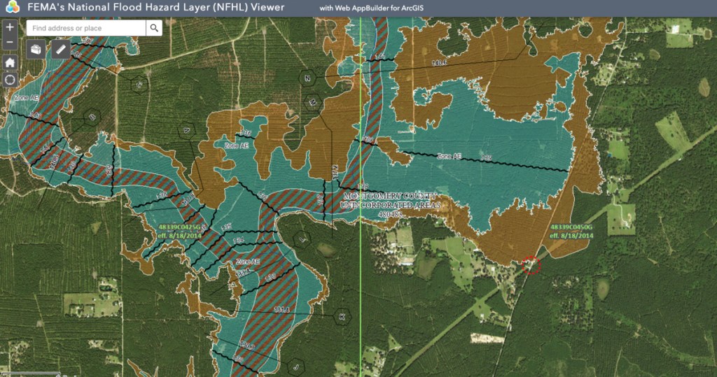
Virtually all of this forest is in some kind of floodplain. See FEMA map below.
Much of Land in Floodplains
FEMA’s National Flood Hazard Layer View shows that large parts of the Signorelli site are in the floodway (striped), 100-year floodplain (aqua) or 500-year floodplain (brown).Photo above this map was taken looking north from red dotted circle.
Keep in mind that the flood map above is based on 2014, pre-Atlas 14 data. The floodplains will expand even further when FEMA updates the flood map.
Current Residents Worry About Development’s Impact on Flooding
I talked to one lady today who lived near the clearing (shown in the first drone photo above) for 55 years. She said she never flooded in all that time. But she worries that she will now. She understood intuitively how the acceleration of runoff from developments, if not properly mitigated, can result in higher flood peaks. She also worried that changes to the slope of the land around her might funnel water toward her property, just as Valley Ranch did to some surrounding homes and businesses.
Only time will tell if her fears are founded. Based on the FEMA flood map above, it appears that Signorelli will need to move a significant amount of earth to elevate homes above floodplains. Signorelli will also likely need to create many detention ponds for an area this large.
Say Goodbye to the Era of Country Retreats
One thing is certain, however. The era of country retreats in this area is history.
https://i0.wp.com/reduceflooding.com/wp-content/uploads/2022/06/20220604-DJI_0603.jpg?fit=1200%2C799&ssl=17991200adminadmin2022-06-04 16:57:322022-06-25 11:27:16Signorelli Developing Another 3,000 Acres Near Splendora
The Texas Water Development Board (TWDB) has compiled an amazing list of resources for those concerned about flooding. Among them: a new Community Official Flood-Resource Guide.
New Community Official Flood-Resource Guide
The Flood-Resource Guide contains information to aid community officials such as floodplain managers, city officials, emergency personnel, and others. While TWDB is targeting community leaders with this particular information, it can benefit anyone concerned about flooding. This guide also makes a great resource for teachers. So why wait for third-parties to convey information to you?
The information includes best-practice guides, links to beneficial websites, videos, and toolkits.
Among the eye-openers for me were results of a statewide survey conducted by TWDB in 2020. One of the questions was, “What are your primary concerns related to flooding?” Amazingly, financial damages fell near the bottom the list. Insufficient infrastructure, preparedness, and poor policy and management topped the list…even above human life!
From page 62 of the 68-page Community Official Flood Resource Guide: Volume One.Based on 300 respondents.
This 68-page Community Official Flood-Resource Guide is packed with useful information that will help you reduce flood risk and talk about it with your relatives, neighbors and friends.
Other Useful Links
The TWDB page where you can download the new Flood-Resource Guide also provides dozens of other links with information that directly targets residents as well as flood professionals.
Start at the TWDB’s Community Assistance Program webpage. Or go directly to topics that interest you. Whether you’re trying to learn how to read a flood map or comply with flood insurance standards, this is one page that has virtually everything you’ll need. I’ve reproduced the links below for your convenience.
Federal Emergency Management Agency (FEMA): FEMA’s website offers extensive information regarding the NFIP, mitigation, disaster information and assistance, preparedness, regional contact information, best practices and publications, just to name a few.
FEMA Map Service Center (MSC): The MSC offers online access to past, current and future Flood Insurance Rate Maps (FIRMs), current and future Flood Insurance Studies (FIS), Letters of Map Change, Flood Map Status Information System (FMSIS), the National Flood Hazard Layer (NFHL) and other associative mapping information. The MSC also offers instructions on how to make a Firmette.
The FEMA Library : The FEMA Library is a searchable web-based collection of all publicly accessible FEMA information resources, including: CDs, DVDs, VHS tapes, audio tapes, disability resources, posters and display items, brochures, publications, guidance and policy papers, program regulations and guidelines, forms and slide presentations.
Mitigation Best Practices Portfolio: Contains a collection of best practices, case studies and mitigation best practices (Hurricane Katrina).
Flood Damage-Resistant Materials Requirements (Technical Bulletin 2) (2008) – Provides guidance on the NFIP regulations concerning the required use of flood damage-resistant construction materials for building components located below the Base Flood Elevation in Special Flood Hazard Areas (both A and V Zones).
3-93 Non-Residential Floodproofing – Requirements and Certification – (FIA-TB-3) – Provides guidance on the NFIP regulations concerning watertight construction and the required certification for floodproofed non-residential buildings in Zones A, AE, A1-A30, AR, AO, and AH whose lowest floors are below the Base Flood Elevation.
Elevator Installation (Technical Bulletin 4) (2010) – Provides guidance on the NFIP regulations concerning the installation of elevators below the Base Flood Elevation in Special Flood Hazard Areas (both A and V Zones).
Free-of-Obstruction Requirements (Technical Bulletin 5) (2008) – Provides guidance on the NFIP regulations concerning obstructions to flood waters below elevated buildings and on building sites in Coastal High Hazard Areas (Zones V, VE, and V1-V30).
6-93 Below-Grade Parking Requirements – (FIA-TB-6) – Provides guidance on the NFIP regulations concerning the design of below-grade parking garages beneath buildings located in Zones A, AE, A1-A30, AR, AO, and AH.
7-93 Wet Floodproofing Requirements (FIA-TB-7) – Provides guidance on the NFIP regulations concerning wet floodproofing of certain types of structures located in Zones A, AE, A1-A30, AR, AO, and AH.
NFIP Watermark: This is an electronic publication providing articles and information on flood insurance and mitigation activities.
FloodSmart: This is the official website of the NFIP offering extensive information on flood insurance and flood risks for communities, agents and homeowners.
Professional Associations
Texas Floodplain Management Association: The Texas Floodplain Management Association (TFMA) is an organization of professionals involved in floodplain management, flood hazard mitigation, the National Flood Insurance Program (NFIP), flood preparedness, warning and disaster recovery. TFMA also offers floodplain management training opportunities in Texas.
Association of State Floodplain Managers at www.Floods.org. The Association of State Floodplain Managers is an organization of professionals involved in floodplain management, flood hazard mitigation, the National Flood Insurance Program, and flood preparedness, warning and recovery. ASFPM has become a respected voice in floodplain management practice and policy in the United States because it represents the flood hazard specialists of local, state and federal government, the research community, the insurance industry, and the fields of engineering, hydrologic forecasting, emergency response, water resources, and others.
To make this post easy to find in the future, I’ll add it to the Links page of ReduceFlooding.com.
Posted by Bob Rehak on 6/4/2022
1740 Days since Hurricane Harvey
https://i0.wp.com/reduceflooding.com/wp-content/uploads/2022/06/Screen-Shot-2022-06-03-at-5.27.08-PM.png?fit=2250%2C1500&ssl=115002250adminadmin2022-06-03 17:53:182022-06-03 17:58:05TWDB Provides Flood-Resource Guide and More


")