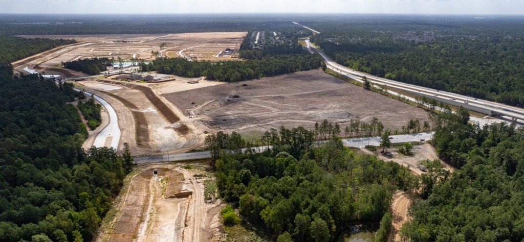
Mavera, a 1700-acre new development in southern Montgomery County at FM1314 and US242 has finished clearing a large section of land northwest of the intersection and started pouring concrete. Signs welcome visitors to model homes. The area, once laced with wetlands now has a massive linear detention pond and uses FM1314 for outflow control.
Looking east just north of US242 on right from over FM1314. Note wet areas in foreground. They correspond to wetlands in map below.Large green area immediately east of 1314 (diagonal) and north of US242 (bottom) correspond to wet areas in photo above. From US Fish and Wildlife Service National Wetlands Inventory Map
Areas west of FM1314 to Crystal Creek are also being cleared, but their current state of development is not quite as advanced.
Likewise, an area east of FM1314 has expanded north, almost to Gulf Coast Road. Neither is its drainage fully developed.
Looking NE at current limit of development. Gulf Coast Road runs diagonally from left to right just beyond tree line.
Long, Linear Detention
The development relies on a wide linear detention basin – more than a mile long! And that’s only the part east of FM1314!
Looking east toward upstream end of detention basin.
Two smaller basins also exist. One is currently by a small park and recreation center.
Looking WSW.Note small retention pond and rec center in upper right.
In the photo above, also note the small swales that outline lots. Will some drainage go overland? Or is underground drainage just not connected to the detention basin yet?
Same spot. Lower elevation. Looking west from eastern portion of Mavera. I’m not seeing any drainpipes from storm sewers entering pond yet.Note three new model homes near center of frame.
The development seems to have undergone a series of name changes. The land was originally known as the Denbury Tract. Later, construction plans and a drainage analysis refer to it as Madera. But now, the builders are marketing it as Mavera.
Screen capture of cover sheet from drainage planshowing first two names of development.
The drainage plans for Mavera (aka Madera/Denbury tract) rely on a hydrologic timing assessment (see last line in screen capture above).
The drainage analysis claims the development will have no downstream impact, but engineers didn’t study those areas. Nor did they study how new development upstream may have already shifted the peak of a flood.
Impact on FM1314?
Long linear detention schemes typically accelerate the flow of water. This one will rely on one culvert under FM1314 to hold back more than a mile of water collected from hundreds of acres. That will put a lot of pressure on FM1314 in a heavy storm.
Looking NW over FM1314. East is to the right. Water will flow west toward Crystal Creek out of frame to the left.
The roadway will act as a dam to detain water collected from almost all of the area shown in the photo below.
Looking east. Virtually all of the cleared area will drain through one culvert under FM1314. FM1314 runs left to right through the bottom of the frame. US242 is on right. Notice how channel is being widened, making culvert off-center. Did someone initially miscalculate or did plans change?
FEMA mapped most of this area in a ten-year flood zone. For the sake of potential home buyers, let’s also hope the engineers got the drainage calculations right.
The thoughts expressed in this post represent opinions on matters of public concern and safety. They are protected by the First Amendment of the US Constitution and the Anti-SLAPP Statute of the Great State of Texas.
https://i0.wp.com/reduceflooding.com/wp-content/uploads/2022/07/20220716-DJI_0152.jpg?fit=1200%2C799&ssl=17991200adminadmin2022-07-16 15:56:422025-08-19 22:11:03Mavera Wetlands Bite the Dust
The Texas Water Development Board (TWDB) recently produced a fascinating short video that puts the current drought in historical perspective by comparing rainfall, temperature, and water supplies to 2011. The text and visuals below are adapted from Dr. Mark Wentzel’s presentation. Wentzel serves as a hydrologist for the TWDB.
Wentzel’s charts depict statewide averages. The Houston region has had significantly more rainfall. So look at Wentzel’s data for trends happening around us. I’ll show Houston data at the end of this post.
Comparison to 2011 Drought
Wentzel says that June was warmer and drier than normal for much of the state, the fourth consecutive month with those conditions. At the end of June, drought conditions covered 86 percent of the state, up eight percentage points from the end of May. Storage in our water supply reservoirs is at 75 percent of capacity, ten percentage points below normal for this time of year. So, Texas is in a significant drought, the worst since 2011, but not worse than 2011.
Highlights of Wentzel video
Statewide Precipitation Averages
The State average rainfall from January to June of this year: 7.8 inches, about 60 percent of normal. Bad as that may be, it’s better than in 2011 when we received less than six inches in the first half of the year, only about 40 percent of normal.
Statewide Texas precipitation averages
Comparison to 2011 Temperatures
On the next chart, Wentzel shows monthly average temperatures across the entire state for both 2022 in orange and 2011 in red. Black dots show the 20th century average for comparison. He shows maximum and minimum temperature records in gray. The gold line represents January to June of this year.
Statewide Texas temperature averages
Temperatures have been above average five out of six months. That additional heat has certainly contributed to drought, but monthly temperatures in the first half of 2011 were even hotter for four of those six months.
In 2011, the real heat came in June, July, and August when we set maximum temperature records each month.
Dr. Mark Wentzel, TWDB
Temperatures the rest of the summer and 2022 are expected to be warmer than average, but not to exceed 2011 temperatures.
Percent of State in Drought
Low rainfall and high temperatures during the first half of 2022 have brought significant drought to Texas. The U.S. Drought Monitor map for conditions as of June 28 shows 86 percent of the state impacted by drought, up eight percentage points from the end of May. More of the state is experiencing drought at the end of June this year than for any June since 2011, when 96 percent of the state was in drought.
Effect on Water Supply
Statewide, our water supply reservoirs are being impacted by the current drought, but not as significantly as in 2011. The dark line on this chart shows how storage this year compares to minimum, maximum, and median values for the day of the year from data going back to 1990. Lighter lines show how we did in 2021 and 2020. The red line shows how we did in 2011.
Texas statewide totals expressed as percent of full capacity
We began 2022 with water supply storage more than two percentage points lower than normal for the time of year. By the end of June, we’ve fallen to about ten percentage points lower than normal.
In 2011, water supply began the year closer to normal, but fell farther and faster than in 2022. By the end of June, storage was about one and a half percentage points less than this year. In the second half of 2022, Wentzel expects additional storage declines, but not as severe as in 2011 when the State reached 30-year lows by mid-October.
Bottom Line for State
We are in a significant drought, even if it’s not as bad as 2011. But the real test won’t come this summer or even this year. Our water supply systems are designed to withstand a multi-year event. Will 2022 lead to a multi-year event? It’s too early to tell, says Wentzel. “But it’s never too early to conserve water and manage demand.”
The top half of the first shows temperatures. It depicts highs in red, average ranges in green, and lows in light blue for ever day of the year. The dark blue lines show actual temperature observations year to date.
The bottom half shows actual precipitation compared to the average. You can see that for part of the year, we were actually above normal. But starting around June 1, we fell behind.
The last chart shows temperatures in July to date. The dark blue lines show actual temps compared to highs, the normal range, and lows for every date. The three stars indicate records or ties.
Posted by Bob Rehak on 7/15/22 based on information from TWDB, NWS and Dr. Mark Wentzel
1781 Days since Hurricane Harvey
https://i0.wp.com/reduceflooding.com/wp-content/uploads/2022/07/20220715-Screen-Shot-2022-07-15-at-5.03.06-PM.jpg?fit=1200%2C670&ssl=16701200adminadmin2022-07-15 18:09:582022-07-15 18:16:32How Current Drought Compares to 2011
In the last few weeks, Michael Bloom, a fellow member of the Harris County Community Flood Resilience Task Force, and I have debated the inherent bias and limitations of a Flood-Mitigation Benefit Index (FMBI) proposed by a majority of the Task Force to Harris County Commissioners Court.
According to Mr. Bloom, the index will:
Reveal and document patterns of historical discrimination.
Help plan where additional flood-risk reduction investments should be made.
Population-Based, Not Damage-Based Mitigation
The formula is:
Benefit = Total Cost/(Population X Risk)
…where:
Cost = total flood-mitigation construction spending (and only construction spending) that benefits a census tract.
Population = the number of people who live in census tracts.
Risk = the annual chance of flooding (applied to census tract(s)) expressed as a whole number. For instance, a 1% annual chance equals 1. And a 10% annual chance equals 10, etc.
The Task Force hopes to calculate and compare the results for each census tract in the county.
The formula measures the historical per capita flood-mitigation costs supposedly associated with the “current” level of risk in a census tract – NOT historical flood damage.
According to proponents, “a high benefit score means no more mitigation spending is needed. And a low score means more spending is needed.”
But consider these two examples:
4,000 people live with a 1% annual chance of flooding and have received $200 in prior investment. Their FMBI would be 0.05. That’s extremely low. And scores that low indicate such areas need help “regardless of prior investment.”
8000 people live in the 10-year flood plain and have received $10 million in prior investment. Their FMBI equals 125. That’s 2,500 times higher.
According to a spokesperson for the FMBI, “A high FMBI means we don’t need to make more investments in that location.” Yet twice as many people live with ten times the risk in the area with the higher index.
So, who deserves the most help? Residents with the lowest FMBI? The formulaSAYS they need help the most. But they actually have the lowest risk.
The Value of Market Testing
None of the hypothetical examples used to “sell” the formula hint at the possibility of such an upside-down result.
The example above proves several things:
The formula can produce inconsistent and misleading results.
Adjusting for population doesn’t prove historical discrimination. The most densely populated area has 50,000 times more investment.
The formula needs rigorous testing and ground-truthing before going any further. This is a best practice for any new scientific formula – especially one intended to guide future investment.
In addition to producing unintended results, the formula has several other problems that require discussion.
No Right-Of-Way Acquisition Costs Included
The FMBI formula includes only construction costs. It excludes right-of-way acquisition costs by assuming that they are “uniform throughout the county.” Therefore, “…costs included or excluded will not adversely impact results.”
In fact, Right-of-Way (ROW) Acquisition costs are huge and NOT UNIFORM throughout the county. I have documented that ROW costs typically comprise the second most expensive part of flood-control projects.
All Flood Control and partner spending on all capital improvement projects from 1/1/2000 through the end of Q3 2021.Data obtained via FOIA Request from HCFCD.
A quick glance at the Appraisal District website will tell you that land costs vary widely throughout Harris County and change over time.
The cost of buying floodplain land or wetlands for preservation in rural parts of Harris County pales in comparison to land acquisition costs in densely populated parts of the county.
In fact, acquiring land in densely populated areas for flood mitigation often costs more than construction, according to several engineers I consulted.
Compounding Problems?
I worry that other methodological issues may compound each other, not cancel each other out.
Map of Census tracts in Harris County, Texas.
Consider that:
Census tract population typically varies by up to 4X (2,000 to 8,000), according to the Census Bureau. This will produce deceptive spatial comparisons.
Some Census tracts may comprise dozens of square miles while others comprise a few city blocks. Typically, flood mitigation projects are not considered at the Census-tract level. According to three engineers I consulted, that’s too small in most cases to be workable.
Larger Census tracts may contain multiple watersheds, each with independent levels of risk – or individual watersheds with varying levels of risk. In such cases, the formula would average risk. But averaging can mask a serious problem in one area with a non-problem in another. Thus, the formula has a bias in favor of spatially smaller Census tracts. Smaller tracts tend to be more uniform in risk, so problems will likely stand out rather than get lost in an average. But in larger watersheds, flood risk will feather out with increased elevation and distance from a river. That will make it extremely difficult to calculate the number of people exposed to varying degrees of risk. Averaging takes the simple way out. But averaging risk is like comparing saints and sinners, then declaring “No problem.”
The data collection effort for the index omitsmany sources of funding. So the formula will calculate investment dollars from some entities and areas, but not others. For instance, the formula will NOT measure drainage funding from Harris County Commissioner Precincts, dozens of cities, and 389 municipal utility districts in unincorporated areas. The difficulty of data collection in these areas will produce another spatial bias. Likewise, the FMBI formula will omit the considerable drainage-improvement contributions of reputable private developers.
No one has tested how these inconsistencies will affect each other. But there’s an even bigger data integrity issue.
Partially Updated Data
HCFCD and its partners invested more than $1.5 billion in flood mitigation between Harvey and the end of 2021. Since 2000, they’ve invested more than $3.5 billion. But as of this writing, new MAAPnext flood maps only reflect the POST-mitigation risk associated with projects in FIVE bayous: Brays, Greens, White Oak, Sims, and Hunting. The Army Corps partnered with HCFCD in those.
Unfortunately, according to a knowledgeable source, HCFCD has not yet updated the risk maps for its own Capital Improvement Projects in other watersheds. So if you ran the allocation formula now, it would compare PRE-mitigation risk in 18 watersheds with POST-mitigation risk in 5.
Mitigation in those five watersheds totals $439 million out of $1.5 billion since Harvey. So true, current risk is reflected in only 29% of spending since Harvey and 13% in this century. Those percentages will no doubt increase in the future. But if you ran the numbers today, you would compare numbers with PRE- and POST-mitigation risk.
And consider this. With HCFCD spending at the current rate of about $80 million per quarter, “current risk” is a constantly changing target. So we’ll never be able to compare apples to apples in all watersheds anytime soon.
And we want to use this formula to guide future mitigation spending? Using it could send more money back to fix areas we already fixed!
Difficulty of Assigning Investments to Census Tracts
Another challenge: How do you determine which census tract(s) to apportion project benefits among? Example: Addicks and Barker Reservoirs. The Army Corps developed those back in the 1930s to protect downtown Houston…15-20 miles away!
Do you credit the investment to:
All of downtown?
People living inside the reservoirs (who have their own census tract)?
The current population of the entire Addicks and Barker Watersheds?
All census tracts along Buffalo Bayou and parts of White Oak Bayou, our second and third most populous watersheds?
And virtually all residents of the Addicks and Barker watersheds live upstream from the Corps’ investment, so they will not benefit from the investment either.
Downtown has immense commercial and economic value but relatively few permanent residents.
So, who gets the benefit? Again, lots of room for interpretation and misplaced assumptions here that numbers can easily mask! Now, multiply this problem times thousands of Census tracts.
Anti-Commercial Bias
The population-based FMBI has a built-in bias against commercial areas that have little to no residential population. For example, consider the cases of Downtown, the Texas Medical Center, and the Port of Houston. Such areas support employment throughout the region, but the formula discriminates against them by giving huge weight to population and omitting actual damage.
No Thresholds Defined
To my knowledge, the task force has never discussed threshhold “benefit” levels that correlate to “needs help” or “doesn’t need help.” The extremes may sometimes be easy to determine. But what about outcomes in the middle?
Offsetting Variables
Variables in the formula can offset each other as we saw above. In tight races for funding, who gets the next flood-mitigation investment? The area with the lowest investment, highest risk, or largest population? Such quandaries have not yet been addressed.
No Agreement on Weights of Other Factors
To help make future flood-mitigation decisions, proponents of the formula also suggest weighing (separately) other factors, such as the CDC’s Social Vulnerability Index. It includes the percentage of Low-to-Moderate residents in an area. However, no one has yet discussed the weight given the Benefit Index relative to other factors.
No Consideration of Actual Flood Damage
In deciding where to put flood mitigation projects, engineers traditionally look for damage clusters. It’s that simple. Dollars flow to damage.
Reducing flood damage is a tried and true, measurable way to evaluate projects. So why all the complexity?
What’s The Point?
What is this formula trying to prove? Is it attempting to develop a new approach to mitigation funding that eliminates a perceived bias in Benefit/Cost Ratios?
Commissioner Rodney Ellis often talks about how calculating the value of avoided damages in higher value homes disadvantages projects in poorer neighborhoods. That can be true in some instances. Expensive homes can ratchet up benefits (measured in dollars) faster than lower value homes can. And that can result in higher Benefit/Cost Ratios for projects in affluent neighborhoods – assuming density is held constant. But…
One high-value home on an acre would likely appraise less than an apartment building, also on an acre. In Kingwood, I compared the valuations of an expensive single-family home with a large apartment complex one block away. The appraised cost per acre (including structures) of the apartment complex is 4X higher.
Now consider that apartments accommodate almost half of Harris County’s population.
According to the latest census data, 54.9% of Harris County residents live in owner-occupied homes. The rest, 45.1 percent, live in apartments.
Most Americans aspire to and encourage home ownership, in part, because of the stability it fosters in communities. But this formula – because of its emphasis on population density – favors apartment areas over areas with owner-occupied homes. There’s nothing inherently wrong with that. You just need to understand what the formula does.
Difference Between Vertical and Horizontal Density
The Benefit Index favors all areas with dense population. Proponents argue that helping more people is better. I don’t argue with that. However, the generalization masks the financial pain inflicted by a flood on owners vs. renters, and on the people who live at ground level compared to those who live above it.
Ground floor renters may lose contents in a flood, but they won’t be responsible for making structural repairs. The owner will.
And many living above the ground floor may find themselves more inconvenienced by flooding than financially devastated. So, is it fair to count all people on all floors when determining who suffers the most pain?
Five-story apartment buildings crowding Brays Bayou with ground-level parking underneath. HCFCD has no way of knowing how many people live in apartments like this, yet HCFCD will be responsible for compiling the data.
In the proposed formula, higher population will lower the benefit index, making it look as though all renters (almost half the county’s population) suffered more than owners of single-family homes.
The premise underlying such “equity” arguments is that poor people can least afford floods. But most people in apartments like those shown above won’t make structural repairs as a homeowner would.
No Perfect Formula
No perfect formula exists that’s equally fair to all in all circumstances. That’s why FEMA, HUD and the Army Corps allow consideration of multiple factors when determining which projects to fund.
The Flood Mitigation Benefit Index focuses totally on population, risk, and past investment. It ignores actual flood damage.
If we use ANY formula to HELP allocate future flood-mitigation funds, we should all strive to:
Understand its built-in biases
Maintain high standards for data integrity.
If we want to test a hypothesis of historical discrimination in flood-mitigation funding, there’s a much simpler way. It’s called direct measurement. Simply locate damage centers from past storms and compare funding in the following decade designed to mitigate those areas.
For More Information
For more background on issues with the formula, see my earlier posts:
https://i0.wp.com/reduceflooding.com/wp-content/uploads/2022/07/20210520-RJR_6978.jpg?fit=1200%2C800&ssl=18001200adminadmin2022-07-14 17:54:142022-07-14 21:58:06Inherent Bias and Limitations of Flood-Mitigation Benefit Index
The Houston-Galveston Area Council of Governments (H-GAC) has allocated $60 million to Montgomery County. The money comes out of a $488 million of Harvey flood-mitigation funds previously allocated to HGAC by the U.S. Department of Housing and Urban Development (HUD) through the Texas General Land Office (GLO). The $60 million is the single largest allocation to any governmental entity in the region out of the $488 million pot.
50% Committed to LMI Areas
At least 50% of the money must go to low-to-moderate income (LMI) areas in Montgomery County. The GLO has determined that MoCo plans meet HUD rules and conditionally approved the allocation.
However, things could still change and Montgomery County has not yet received the money.
According to H-GAC, the conditionally approved preliminary method of distribution (a plan for whom gets how much) is still pending acceptance by eligible entities and is subject to change through a published re-allocation process. A complete list of eligible activities is available in the Texas General Land Office (GLO) guidelines for the Regional Mitigation Program – Council of Governments Method of Distribution (COG MODs). Depending on changes, another 30-day public comment period may necessary, according to the GLO.
Where, How MoCo Will Spend the Money
I reached out to the Montgomery County Judge’s office to see how MoCo hopes to spend the money. Jason Millsaps replied, “Montgomery County will attempt several projects with these funds as soon as final approval has been granted.”
Millsaps continued, “In East County, we will work to de-snag, de-silt and remove vegetation that hinders flow from the Peach Creek, Caney Creek, White Oak Creek, and East Fork of the San Jacinto River. We will do the same for Lake Creek and Stewart Creek in Central/North County, with additional bank armor going in for Stewart Creek near the River Plantation Subdivision.”
Peak flows in the San Jacinto Watershed during Hurricane Harvey
Posted by Bob Rehak on 7/12/22
1778 Days since Hurricane Harvey
https://i0.wp.com/reduceflooding.com/wp-content/uploads/2022/07/20220712-Screen-Shot-2022-07-12-at-1.17.19-PM.jpg?fit=1200%2C729&ssl=17291200adminadmin2022-07-12 13:31:032022-07-12 13:46:36Montgomery County Allocated $60 Million in Harvey Mitigation Funds
At 2pm EDT on 7/11/22, the National Hurricane Center (NHC) issued an update that shows an area of concern offshore that stretches from Galveston Bay to the Florida Panhandle. NHC currently gives it a 30% chance of developing into something more serious in the next five days (10% in two days).
Area of low pressure sitting offshore on Monday afternoon at around 2PM.
Heavy Rain, Flash Flooding Likely East of Houston
This broad trough of low pressure is producing a large area of disorganized showers and thunderstorms. According to NHC, gradual development within this area of concern is possible if it can remain offshore while it meanders near the Gulf coast through the end of the week.
Regardless of development, heavy rains will be possible along portions of the northern Gulf coast from Louisiana to the Florida Panhandle over the next several days. For more information about the potential for heavy rain, see local National Weather Service forecasts and/or the Weather Prediction Center.
While the main danger from heavy rains currently lies to the east, global models are not yet unanimous in their forecasts. Jeff Lindner, Harris County Meteorologist says, “Global forecast models show some development of this trough into a closed area of low pressure mid- to late-week. Steering currents become very weak late week … with high pressure building into the Plains.” That will cause any tropical system over the northern Gulf to meander. Lindner added that the consensus among forecasters this morning kept any development well east of Houston.
Heat Records Fall Throughout Region
In the meantime, we could use a break from the blistering heat. Numerous records fell over the region yesterday.
College Station: 111 (exceeded July monthly record of 110 set in 1917)
BUSH IAH: 105 (exceeded daily record of 101 from 1998)
Hobby: 104 (exceeded daily record of 100 from 1964)
Galveston: 96 (tied daily record of 96 from 1931)
Posted by Bob Rehak on 7/11/2022
1777 Days since Hurricane Harvey
https://i0.wp.com/reduceflooding.com/wp-content/uploads/2022/07/two_atl_5d0.png?fit=900%2C665&ssl=1665900adminadmin2022-07-11 14:27:462022-07-11 19:10:39Offshore Area of Concern
On 7/5/2022, demolition began on the first of three townhome complexes remaining on Marina Drive in Forest Cove. The complexes had been damaged beyond repair when 240,000 cubic feet per second of stormwater roared through them during Hurricane Harvey.
Since then, the abandoned properties had become magnets for drug dealing, arsonists, and illegal dumping. But the buyout process stalled when owners of some of the units could not be found. The county had to exercise its powers of eminent domain on those by declaring the purchase of several units a “public necessity.”
Now, with legalities out of the way, demolition began at 4:45 Tuesday afternoon. You could almost hear a collective sigh of relief from Forest Cove residents. Removal of the eyesores will restore the community’s image while eliminating a public safety hazard.
Photos of Demolition
Here are some pictures taken between 7/5 and 7/9/22. All that’s left of the first complex is a shrinking pile of rubble, some twisted girders, and some driveway.
Beginning of Forest Cove Townhome Demolition on 7/5/22By end of second day, 7/6/2022, half of first complex was down, but most of rubble remained.By end of third day, 7/7/2022, entire first complex was down. Contractors compacted rubbleto make it easier to haul it away.They also separated girders from the rubble.This EPA article describes recycling opportunities for demolition waste.End of fourth day, 7/9/22. Most of waste was hauled away. Practically nothing remains of first building.Second complex in background will come down next week.Pile of twisted girders. Remnants of a once proud townhome complex and a laid-back river lifestyle.Next up for demo: the building in background.
Next Steps
The next steps:
Demolish building in photo above 7/14/22.
Schedule demo of third building as soon as last buyout is completed.
Kudos to Harris County Flood Control and its contractors. This is not easy work when the temperature soars into triple digits. Their efforts will make a huge difference to the community.
Posted by Bob Rehak on 7/10/2022
1776 Days since Hurricane Harvey
https://i0.wp.com/reduceflooding.com/wp-content/uploads/2022/07/20220707-DJI_0084.jpg?fit=1200%2C799&ssl=17991200adminadmin2022-07-10 14:21:342022-07-12 16:31:17Forest Cove Townhomes: One Down, Two to Go
The letter below expresses disagreement with two recent ReduceFlooding.com posts about a proposed Flood Mitigation Benefits Index. It is from Michael Bloom, P.E. While I disagree with almost all of his claims, I am reprinting his letter verbatimbecause I encourage healthy debate. Compare the posts and draw your own conclusions. – Bob Rehak, Host, ReduceFlooding.com.
Why are we Using the Index When it Produces Inconsistent Results that are Not Intuitive? Mr. Rehak provides an example that holds the current population and current risk the same, but changes the total prior investment amounts, as illustrated in the table below:
Prior Investment ($)
Current Population (Number)
Current Risk (% Annual Chance)
FMBI
Area A
100,000
5,000
10
2
Area B
1,000,000
5,000
10
20
Mr. Rehak looks at these results and writes: “So, spending more money to get the same results increases benefits? Shouldn’t it be the opposite? That’s both depressing and confusing. You spend 10X the money; flood risk remains the same; and the “benefit” increases!!!??? You would think spending less money to achieve identical results would be more beneficial. It certainly is for taxpayers.”
Everyone should be depressed and confused by this result if the FMBI was illustrating the results for the same location. Mr. Rehak appears to make that inference when he writes: “spending more money to get the same results increases benefits.”
But Area A and Area B are two different locations. The FMBI is just telling us what the current conditions are at two different locations in the county. One location had 10 times the prior investment than the other – but both locations still have the same current risk.
Worse, in this case, BOTH locations have risks that are ten times the current standard of care for new developments – which require structures to have less than a 1% annual chance of inundation. Clearly, both locations need more flood risk investment. The FMBIs of 2 and 20 both are extremely low, meaning they need help, regardless of the prior investments. A high FMBI indicates that no additional help is needed in that location. A low FMBI indicates that additional help is needed in that location.
The table included in the middle of my February 17, 2022, post entitled “How Should We Decide Where to Invest in Flood Risk Reduction?” presents additional examples showing how the FMBI changes from location to location with only one changed variable. It also provides narrative explanations of each sequence. Notice how the index values are greater than 3,000 (sometimes greater than 20,000 or 100,000) in locations where the current annual chance of inundation is less than 1%? Again, a high FMBI means we don’t need to make more investments in that location. A low FMBI means that location needs more help.
Isn’t the FMBI Trying to Prove Inequitable Investments in Flood Risk Reduction? To some extent, partially, yes, it is. This was always an important aspect of the FMBI, when it was originally proposed as the “Flood Benefits Index (FBI)” by Dr. Erthea Nance and Iris Gonzalez in May 2021. I have continued to advocate for its use as one of four input variables we should use to create our county-wide “heat map.” This is explained in more detail in my other article. Mr. Rehak is concerned about the taxpayer. I am also. I don’t think the taxpayers of Harris County should pay for flood risk reduction projects in areas that already have a high FMBI. Said another way, it is a waste of taxpayer money to invest in additional flood risk reduction projects in areas currently with less than a 1% annual chance of inundation.
Isn’t the FMBI Measuring per capita Investment Associated with a Certain Level of Flood Risk and Mistakenly Calling that a “Benefit?” Mr. Rehak writes: “The more people you help with any given sum, the more the benefit goes down. Voila! That makes it look as though the highly populated watersheds (that have received the overwhelming majority of prior investments) have received little benefit. And that may be the point of this formula. It will send even more money to those same areas.”
This interpretation again seems to stem, I think, from Mr. Rehak’s belief that the index will be used to compare the same location at different times – before and after various investments. This is not the proposed use of the index. The proposal is to use the index to describe the current conditions at all locations in the county at the same time.
I’m not sure I understand Mr. Rehak’s concern about the index being a per capita value. The more people in an area who benefit from prior investments the better. Wouldn’t we want to invest in areas that help the most people?
The blue-shaded area of the table in my earlier post illustrates how population differences between locations will change the index value among those locations. For convenience I’ve repeated the table below:
Hypothetical examples.
Mr. Rehak accurately notes that the index goes up in locations with fewer people and down in locations with more people; this will incentivize planners to direct future investments in those higher population areas. He writes: “The more people you help with any given sum, the more the benefit goes down.” This is true, but Mr. Rehak’s statement doesn’t connect it to the past and it omits how the index will be normalized by area size. Index values will be calculated for similarly sized areas. This will allow an apples-to-apples comparison of per capita investments. The index is intended to incentivize future investments in areas with more people in cases where risk and prior investments are equal because we want to help as many people as possible.
By Michael Bloom, P.E.
Posted by Bob Rehak on 7/10/2022
1776 Days since Hurricane Harvey
If you have views on this subject, please share them through the contact form on this website.
https://i0.wp.com/reduceflooding.com/wp-content/uploads/2022/07/20220709-Screen-Shot-2022-07-09-at-4.37.23-PM.jpg?fit=1167%2C1200&ssl=112001167adminadmin2022-07-10 09:35:492022-07-10 09:50:38Response to Concerns About Flood Mitigation Benefits Index (Part II)
The letter below expresses disagreement with two recent ReduceFlooding.com posts about a proposed Flood Mitigation Benefits Index. It is from Michael Bloom, P.E. While I don’t agree with all of his claims, I am reprinting his letter verbatimbecause I encourage healthy debate. Compare the posts and draw your own conclusions. – Bob Rehak, Host, ReduceFlooding.com.
In addition to getting to know Mr. Rehak while attending CFRTF meetings, Mr. Rehak and I have sat down, in person, a few times since both being appointed to the Task Force in order to discuss difficult issues, in particular the FMBI. I appreciate his candor and our ability to respectfully debate things – one might say – politely argue. This post (and Part II) are extensions of those discussions so others can benefit from the exchange.
The index is intended to be calculated for all locations in the county at one particular time to help define the baseline conditions. The index will be used to help plan where additional flood risk reduction investments should be made. An area with a high FMBI has already received higher per capita investments, has a low risk, and therefore doesn’t need additional help. An area with a low FMBI has received little per capita prior investments, has a high risk, and therefore does need additional help.
Responses to Specific Concerns
Which Type of Project Costs Are Included? Does including construction costs, but excluding design, right-of-way acquisition, and operational costs skew the data? Since this is an index that will be calculated for all areas of our county, costs included or excluded will not adversely impact the results. Using the index to compare conditions in various areas within our 1,700 square mile county will still be valid if the index is calculated in all areas of the county the same way. This is an example of “normalizing” the data. It allows for an apples-to-apples comparison among and between locations. It will help us pick where to invest in the future. Since land acquisition, design, and other non-construction costs are often a similar percentage of the construction costs, their exclusion from all index calculations will keep things consistent and unskewed.
Which Agency Investments are Included? Will excluding investments from Harris County Commissioner Precincts, cities, municipal utility districts, and other entities skew the data. I actually agree with this, the investment dollars will be slightly low, but only by a little bit. I anticipate that the total amount of flood risk reduction investment dollars made by these entities will be very, very, very small compared to those made by the Harris County Flood Control District (HCFCD) and the Civil Works program of the U.S. Army Corps of Engineers (USACE). Because of this difference in the size of these investments, I anticipate that the impact on the index calculation will be negligible. HCFCD has agreed to provide their investments from 2000 to 2020. Dr. Denae King and I have submitted a Freedom of Information Act (FOIA) request to the U.S. Army Corps of Engineers, the Federal Emergency Management Agency (FEMA), and the Natural Resource Conservation Service (NRCS) to identify all flood risk reduction investments going back to 1937 – the year the HCFCD was created to serve as the “local partner” to help secure federal investments through the USACE. These requests exclude repair and recovery dollars since those expenditures don’t permanently reduce flood risks.
What Risk is Included in the Index? Does the risk used in the calculation reflect the risk before or after mitigation efforts? The risk value used is the current risk. It is the risk remaining after accounting for all risk reduction investments “counted” in the numerator. The index reflects one point in time and should be recalculated every five years or ten years, much like the Social Vulnerability Index published by the Centers for Disease Control. The population and risk values will be based on the same snapshot in time. The investment value will be based on the sum of all investments made prior to that moment in time (adjusted for inflation).
Why Include Investments Back to 1937? Why consider investments made in areas of the county that were undeveloped back then? Won’t this radically skew the comparisons? Including all investments back to 1937 is vitally important because the vast majority of the flood risk reduction investments made in the county were made by the federal government through the Civil Works program of the USACE. HCFCD was CREATED in 1937 to be the local sponsor for USACE projects. Addicks, Barker, Buffalo Bayou, Brays, White Oak, Sims, Clear Creek, and many other projects, many of them initiated prior to 2000, all significantly reduced flood risks for structures that exist today. Even if the project was initially constructed in an undeveloped area, it still benefits structures that were built later and that exist today. That’s why the investment amount is a cumulative value (inflation-adjusted) and the risk value is today’s value. This approach won’t radically skew comparisons because all three of the values will be determined for all parts of the county in the same way.
Why only Consider Mitigation Investments? Doesn’t flood risk depend on many factors – not just mitigation investments? Yes, current flood risk depends on many factors, including development rules, building codes, finished floor elevations, development locations, and improvements to our understanding of rainfall statistics. The risk value in the index is not intended to measure the risk reduction obtained from prior investments. The risk value in the index is intended to present the current risk. The current risk reflects all factors, including prior mitigation investments, development, rainfall, and everything else. The risk value is not a measure of the change in risk, it is a statement of the current risk, no matter the cause or the contributing factors.
Why Use US Census Tracts? Don’t they change over time? US Census Tracts do periodically change, however, that will not diminish the value of the index. US Census Tracts are areas that can more closely match the scale of typical flood risk reduction projects; watersheds are too large to be informative; and smaller areas would be too complex for our planning work.
Harris County outlined in red, census tracts in blue. Map supplied by Michael Bloom.
The originally proposed FMBI used the population density in the denominator. This, admittedly, would cause issues when comparing index values between large US Census Tracts and small US Census Tracts. To address this issue, the CFRTF and the Infrastructure Resilience Team (IRT) have agreed to proceed with the calculation using just population. This will make the index a per capita value. Prorating investment amounts and risk to each Census Tract can be reasonably accomplished using area ratios or other methods. This will be useful as the CFRTF and IRT work together to prepare the 2050 Flood Resilience Plan.
How Can We Use Information From 1937 When the County is So Different Now? How can this approach work without considering the construction of Lake Houston in 1954, the interstate system, Beltway 8, and the conversion of farmland and prairies into entire communities? The risk value captures all of this. The risk value used in the index reflects the current risk of any part of the county. It will be based on state-of-the-art modeling being conducted as part of the MAAPNext project. The current risk is the current risk, regardless of past changes in the watershed.
Why are we Using the FMBI Formula to Reduce Flood Damage when it Doesn’t Measure Flood Damage? The FMBI is not a tool to directly reduce flood damage and it’s not designed to measure flood damage. The FMBI is a tool to better understand past investment patterns and current risk. The FMBI is proposed to be one of four datasets used to create a baseline conditions heat map. The other three under consideration include current inundation risk, social vulnerability index, and community resources. The baseline conditions heat map will then be used to figure out WHERE flood risk reduction and flood damage reduction projects should be located.
How Can the FMBI Compare Benefits without Using Before and After Comparisons? The index is not intended to compare the flood mitigation benefits of the same location at different times. The index is intended to show how different locations across the county at the same time vary when compared to each other. This will help us identify WHERE we have neighborhoods that desperately need help and WHERE we have neighborhoods that don’t.
By Michael Bloom, P.E.
Posted by Bob Rehak on 7/9/22
1775 Days since Hurricane Harvey
Part II will be posted tomorrow.If you have thoughts you would like to share on this subject, please send them via the contact form on this website.
https://i0.wp.com/reduceflooding.com/wp-content/uploads/2022/07/HC.Census.Blocks-e1657399750631.jpg?fit=1200%2C873&ssl=18731200adminadmin2022-07-09 15:49:522022-07-09 16:24:29Response to Concerns About Flood Mitigation Benefits Index (Part I)
Today, I discovered a fascinating 49-page document produced by the National Weather Service, the National Hurricane Center, NOAA and the National Climatic Data Center. It contains hurricane records going back to 1851. It covers the deadliest, costliest and most intense U.S. tropical cyclones and other frequently requested facts. Unfortunately, it only goes through 2010. But the wealth of information on the period it covers more than makes up for that.
Like the Baseball Encyclopedia for Weather Geeks
It’s like the Baseball Encyclopedia for tropical storms…a must read for weather geeks and anyone who wants to impress out-of-town friends. Texas plays a prominent role in this chronicle.
From Page 8. Mainland United States tropical cyclones causing 25 or more deaths, 1851-2010. The black numbers are the ranks of a given storm on Table 2 (e.g. 1 is the deadliest all-time – the Galveston Hurricane of 1900). The colors are the intensity of the tropical cyclone at its maximum impact on the United States.
A look at the lists reveals striking facts. For instance:
Fourteen out of the fifteen deadliest hurricanes ranked Category 3 or higher intensity
Large death tolls resulted largely from storm surge 10 feet or higher
A large portion of the damage in some of the costliest storms resulted from inland floods caused by torrential rains
One third of the 30 deadliest hurricanes ranked category 4 or higher
Only seven of the 30 deadliest hurricanes occurred between 1985 and 2010 while more than two thirds of the costliest hurricanes occurred during the same period.
A Look Behind the Facts
All costs are adjusted for inflation, so that’s not the major issue. Migration is. 1990 Census data showed that 85% of U.S. coastal residents from Texas to Maine had never experienced a direct hit by a major hurricane. But we have more risk now because more than 50 million people have moved to coastal areas since then.
The study warns, “If warnings are heeded and preparedness plans developed, the death toll can be minimized. However, large property losses are inevitable in the absence of a significant change of attitude, policy, or laws governing building practices (codes and location) near the ocean.”
Filled with Tables, Maps and Insight
One of the most interesting features: maps that show the tracks of record setting storms during the entire period and during each decade.
Amaze your friends with trivia, such as:
Average number of tropical cyclones per year AND how it has varied in different periods.
Years with the most and least hurricanes and landfalls.
Earliest and latest hurricane formations (hint: March 7 and December 31).
Longest- and shortest-lived hurricanes.
Lowest pressure in the Atlantic basin.
Most hurricanes occurring in Atlantic basin at one time.
Number of hurricanes in each month.
Hurricane strikes of various categories by state.
When hurricanes are most likely to strike different areas.
Average return periods for hurricanes in different areas.
Hurricane landfall CYCLES.
That last one really caught my eye.
Hurricanes tend to cluster in certain areas during certain decades!
Biggest Lesson Learned
The study concludes with another warning. “The largest loss of life can occur in the storm surge, so coastal residents should prepare to move away from the water until the hurricane has passed! Unless this message is clearly understood by coastal residents through a thorough and continuing preparedness effort, a future disastrous loss of life is inevitable.”
This is a genuine work of scholarship dished up in a way that makes it accessible to the general public. That takes some talent! Credits go to Eric Blake and Christopher Landsea of the NHC, and Ethan Gibney of the National Climatic Data Center.
Posted by Bob Rehak on 7/8/22based on a study by NOAA, NWS and NCDC
1774 Days since Hurricane Harvey
https://i0.wp.com/reduceflooding.com/wp-content/uploads/2022/07/20220708-Screen-Shot-2022-07-08-at-7.11.56-PM.jpg?fit=1200%2C753&ssl=17531200adminadmin2022-07-08 19:27:262022-07-08 19:32:28Hurricane Records
The presentation begins with a history of the relationship between the Army Corps and HCFCD dating back to 1937. It references past joint projects such as work on the Addicks and Barker Reservoirs; and Brays, White Oak, Little Vince, Cypress, Greens and Sims Bayous.
It also references projects not yet completed such as work on White Oak and Hunting Bayous, and Clear Creek. Finally, it looks forward to future collaboration on Buffalo Bayou, Halls Bayou and a County Wide-Study that “lifts up and empowers our diverse communities to thrive.”
The intro contains graphics that summarize:
Damage during Hurricane Harvey
Atlas-14 rainfall vs previous estimates
Current and Active Army Corps projects
A county-wide map of “Recently flooded” (from Harvey) structures overlaid on a social-vulnerability map
The leave-behind then makes three “asks” corresponding with each of the three major projects.
Buffalo Bayou and Tributaries Resiliency Study
The first ask is for help “finding the right solution for Addicks and Barker Reservoirs.” It talks about managing residual risk and liability. Specifically, it asks for support through the completion of the Corps’ Buffalo Bayou and Tributaries Resiliency Study.
It alludes to policies and processes impeding needed progress. Then it says, we must blaze a trail for a new equitable flood risk management paradigm.
An engineer familiar with Buffalo Bayou told me that the study had been cancelled at one time because of a poor Benefit/Cost Ratio. It wasn’t because, as you often hear, that home values were low. It was because land acquisition costs were so high. Possible workarounds: several proposed “innovations” including:
Flood tunnels
A comprehensive benefits framework that includes more than a strict benefit/cost ratio.
“Emphasis on community resiliency, environmental justice, and climate change adaptation.”
The last update of this study on the Corps’ website is from late 2020. The final report has not yet been released. This post from 2020 summarizes the findings of the interim report.
County-Wide Section 203 Study
Section 203 of the Water Resources Development Act was amended to let non-Federal sponsors conduct feasibility studies that serve as the basis for authorization of new water resources projects, such as flood tunnels. But acceptance of the results is at the discretion of the ASA (CW). One objective of the presentation: to get the ASA(CW) to partner Harris County on a County-wide flood risk study.
The county pitched the partnership as:
A potential “pilot study for Justice40”
Climate change preparedness
Empowering vulnerable communities to withstand and recover from flood events.
Justice40 is a Biden initiative, announced within his first few weeks in office. It uses every lever at his disposal “to advance environmental justice and spur economic opportunity for disadvantaged communities. The “40” refers to Biden’s promise to deliver at least 40 percent of the overall benefits from Federal investments in climate and clean energy to disadvantaged communities. One of the priorities: mitigation initiatives that reduce or eliminate the risk of repetitive flooding.
Halls Bayou Section 118 Study
According to the presentation, the Federal government had a project to study flood-risk management on Halls Bayou from 1990 to 2016 when it was “de-authorized.” The county wants to restart it. Section 118 refers to “Pilot programs on the formulation of Corps of Engineers’ projects in … economically disadvantaged communities.”
Harris County wants the Corps to include Halls on its list of ten nationwide pilot studies for such communities. HCFCD points out that Halls has the highest percentage of Low-to-Moderate Income residents of any watershed in the county (71%). Halls has a poverty rate of 28% and a social vulnerability index of 0.85 out of 1.00. Halls also has frequent, severe, repetitive flooding.
At one time, HCFCD cancelled Halls’ Bayou studies because they all came back with Benefit/Cost Ratios below 1.0. That means costs exceeded benefits. HCFCD hopes to restart those in 2022. Section 118 gives the ASA (CW) a way to apply other criteria that compensate for a low BCR in disadvantaged areas.
Posted by Bob Rehak on 7/7/22
1773 Days since Hurricane Harvey
https://i0.wp.com/reduceflooding.com/wp-content/uploads/2022/07/20220707-Screen-Shot-2022-07-07-at-12.32.19-PM-2.jpg?fit=1200%2C737&ssl=17371200adminadmin2022-07-07 18:31:582022-07-07 18:33:16HCFCD Asks for Army Corps Help with Tunnels, Halls Bayou, Addicks/Barker