As if on cue, I ran a post about restoring competence to local government, and voila, within hours, people started reporting voting problems across Harris County. The problems appear widespread, intermittent and random. They were not limited to areas that leaned Republican or Democratic.
The main effect? Long wait times. One location reported a five-hour line! At another location, a source told me that fifty people were turned away.
The main reasons: Scanners that wouldn’t scan; printers that wouldn’t print; missing supplies; internet glitches; lost keys; lack of testing; not enough setup time; and not enough technical support to resolve issues quickly.
Central Kingwood Mid-Day Report
I personally visited six locations in Kingwood between 11 am and 2 pm. At each, I talked to multiple people.
Four locations seemed to run smoothly. Two had long lines and delays (Kingwood Community Center, Foster Elementary). The problems at the Community Center were unclear. At Foster, several machines went down. Voters experienced half-hour to one-hour wait times at these two locations.
Local news covering long lines at Foster Elementary before lunch today.
At Foster, people exiting talked about scanners being down. Officials asked them to put their ballots in a box and said they would be counted later. Given the level of distrust and skepticism lately, the voters immediately suspected the worst.
They were mad as hornets!
One person complained about his ballot misprinting. It printed Page 1 twice, but wouldn’t print Page 2 at all. Another complained of scanners shredding his ballot.
Handicapped voting seemed to be a problem everywhere. At Kingwood Middle School, a friend and I had to help an elderly woman get from her vehicle to inside the polling location. Elsewhere, I noticed handicapped people coming out of polling places on scooters. Most locations had traffic cones in the handicapped parking places. Several people complained about handicapped call buttons not working or not being accessible.
No Problems at Some Locations
Creekwood Middle School, Good Shepherd Episcopal, Woodland Hills Elementary, and Kingwood Middle School seemed to function properly at mid-day. Many other locations may have been functioning properly, too; I just didn’t check them all.
The last three locations are all adjacent to each other on Woodland Hills Drive between Tree Lane and Pine Terrace Drive.
If you experience problems at your normal voting location, you should be able to vote at any one of them. They’re all within a block of each other. And if one goes down, you have two backups nearby. Also, because of their proximity, the lines are short – at least they were at mid-day.
Wait-Time System May or May Not Work
HarrisVotes.com is supposed to show the wait times at polling locations near you. But caution, if you see zero in line, it may be an error. Both party election officials and Harris County employees have told me the system malfunctioned throughout early voting. It often reported no lines when lines were down the block. So before you get in your car, have some backups in mind.
Note update time as of 6:20 PM tonight. This is likely an error.Foster had long lines most of the day due to malfunctions.
Remember, if you’re in line when the polls normally close at 7, they have to let you vote.
Late Breaking News
At 6:20 PM, the Houston Chronicle reported that a Harris County district judge signed an order keeping the polls open until 8 PM because of all the problems experienced today. They were originally set to close at 7 PM. However, anyone who arrives after 7 PM will have to vote a provisional ballot, a long, complicated process.
Suggestion
In the future, I hope Texas adopts a voting period, and drops the charade of early voting and Election Day. This should simplify procedures and logistics for both election workers and voters. Why do we expand the number of machines and polling locations AFTER most people have voted?
Posted by Bob Rehak on 11/8/2022
1897 Days since Hurricane Harvey
https://i0.wp.com/reduceflooding.com/wp-content/uploads/2022/11/20221108-RJR_1040.jpg?fit=1200%2C800&ssl=18001200adminadmin2022-11-08 17:11:422022-11-08 19:41:01Voting Problems Reported Across County
Harris County is electing a new County Judge this year. For the Lake Houston Area, it’s arguably the most important race on the ballot. It represents a chance to win a majority on Commissioners Court sensitive to the Lake Houston Area’s needs. We’ve been de-prioritized for four years. Tomorrow, November 8th, is your last chance to change that. It’s Election Day.
Why This Race is So Important
I don’t want to downplay the importance of other races. But this particular race is about your quality of life. Getting your fair share of flood-mitigation funding. Keeping your tax bill stable. Restoring public safety. Rebuilding competence in local government. And increasing transparency.
But four years ago, 63% of all ballots were cast during the early-voting period. So turnout on Election Day will be critical this year.
The number of people who have not yet voted in the Lake Houston Area have the power to swing this election. By all accounts, it will be close.
Overview of Candidates: Problems Vs. Potential
The two candidates are incumbent Lina Hidalgo and challenger Alexandra del Moral Mealer.
Hidalgo (D), left; Mealer (R), right
Let’s look at their respective records.
Hidalgo’s only real-world job experience before assuming the helm of a 16,000-employee organization was reportedly as a medical interpreter. Her rookie errors were predictable. I’ll detail them below.
Mealer is also a newcomer to politics, but comes to the job with vastly more real-world experience. She:
Graduated from West Point
Was a Captain in the Army
Commanded a bomb squad in Afghanistan for a decade
Obtained MBA and JD degrees from Harvard
Put together billion-dollar deals in the oil-and-gas sector as a VP for one of the nation’s largest banks.
More About Hidalgo’s Record
Hidalgo had no management experience when elected. And it showed. Under Hidalgo, the County’s budget increased along with employment. She created six new departments. Hired thousands of new employees. And paid for the largesse by drawing down the county’s reserve funds.
She also replaced the heads of 19 departments. One department had three leadership changes under Hidalgo. And four had at least two. Some departments, such as Engineering, have lost 4-5 layers of management. Whole capabilities, such as disaster relief, were wiped out. And every group head in the IT Department (Universal Services) left.
Political credentials became more important in hiring decisions than professional competence. Knowledgeable, capable employees left county employment in droves. Some are still there. But it’s reportedly getting harder and harder for them to keep things running.
One Misstep after Another
I’ve learned to judge Judge Hidalgo by her actions, not her words.
She talks about serving the entire county, but I’ve only seen her break ranks with her Democratic Commissioners twice in four years. In fairness, there may have been more times. But it’s hard to sit through meetings that have lasted up to 16 hours. Robert’s Rules of Order are not her strong suit.
Much to her discredit, Hidalgo led efforts to:
Create a redistricting plan that forced Jack Cagle and Tom Ramsey to switch districts, a move that:
Disrupted service to half of Harris county
Denied former Precinct 4 residents of their right to vote for Commissioner.
Left Precinct 3 (which the Lake Houston Area is now in) with 47% of the roads and 25% of the budget.
Replace highly skilled professionals in the County’s IT department with political loyalists who couldn’t reboot the County’s bail-bond system after it crashed. As a result, hundreds of criminal suspects didn’t receive probable cause hearings in time. So, they had to be released.
But Hidalgo’s greatest sin, in my opinion, is that she destroyed trust in county government by misleading people. For instance, she:
Tried to minimize the impact of a tax rate increase without projecting the impact on a family’s tax bill, given large increases in valuations during her tenure.
Argued for “worst first” in flood mitigation. But her definition has nothing to do with depth of flooding, deaths, loss of critical infrastructure, or the percentage of damaged homes and businesses in a community.
Redefined “equitable” distribution of funds in voter-approved flood-bond language, so that equitable has nothing to do with the dictionary definition.
Says she can’t rely on partner funding for flood-mitigation projects, when she has had $750 million in HUD funding sitting on the table for 17 months. Her Community Services Department (which changed leadership three times under Hidalgo) still hasn’t submitted one project for approval to the GLO or HUD. The $750 million could fully fund every project in the flood bond.
Says she values community input but has never attended a Community Resilience Flood Task Force meeting.
As far as I can tell, after four years, Hidalgo still has not figured out how to run Harris County. She’s just a bad manager. She came to the job with no experience and has not learned along the way.
More about Alexandra del Moral Mealer
Mealer has actual leadership and job experience. Her military and business background is far more qualifying than Hidalgo’s. Mealer has Harvard MBA and JD degrees, and years of experience as a VP of a bank that has almost two trillion dollars in assets. She’s more equipped with the skill sets needed to be a county judge than Hidalgo ever was.
Mealer also has a laser focus on the things that matter to people at the county level: Crime. Courts. Jails. Flooding. Roads. Budgets. Taxes. She refuses to get bogged down in national issues that she has no control over.
She has a conservative fiscal stance on how to spend OUR money. And it doesn’t involve creating jobs for political cronies through a vast expansion of the bureaucracy.
Virtually every law enforcement agency in the county has backed Mealer’s plan for addressing crime.
She hopes to lower or maintain taxes and tax rates by eliminating wasteful spending.
Finally, having met and talked to Mealer at length several times, I believe she cares about all areas of Harris County regardless of their economic status. Said another way, I think she would treat all people and neighborhoods fairly. Mealer has integrity.
November 8th – Your Last Chance
Tomorrow is your last chance to make a change if you want one. If you’re happy with having the deepest flooding in Harris County and seeing flood-mitigation funding go elsewhere, then by all means, vote for Hidalgo. If you’re happy with soaring crime and revolving-door jails, vote for Hidalgo. But if you want to change that, vote for Mealer.
As proof of how dangerous clearcutting without sufficient mitigation can be, the controversial Royal Pines development has flooded a neighbor on a rain that was less than 1″ – even as the Lake Houston area flirts with drought.
Royal Pines sits at the northern end of West Lake Houston Parkway in Montgomery County. Looking SE from NW corner on 10.31.22.
The circumstances are similar to those of a nearby development – Woodridge Village. There, clearcutting flooded Elm Grove Village and North Kingwood Forest twice in 2019. Without sufficient detention basins, sheet flow from approximately 268 acres swept through hundreds of homes. But those incidents weren’t during a drought. And the rainfalls were much heavier.
Less than an Inch of Rain
In this case, the rain fell on October 28, 2022. Harris County’s Flood Warning System recorded a peak of .72 inches of rain in an hour at the nearest gage. To put that in perspective, .72 inches is so slight that it would have had to have fallen in five minutes to qualify as a five-year rain or ten minutes to qualify as a one-year rain.
NOAA’s Atlas 14 rainfall probabilities
However, the rain was spread out over about a half hour.
And the soils were not saturated either. The Lake Houston Area has been in drought for much of the year. As of 11/5/22, the US Drought Monitor rated this area “abnormally dry.”
From US Drought Monitor
During the entire month before October 28, the area had received only a little more than a half inch of rain.
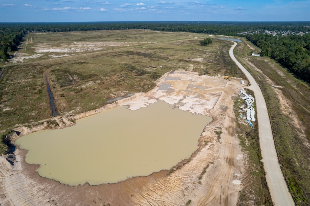
The flooding occurred in the northwest corner of the new development. From pictures and emails supplied by the neighbor, aerial photos taken during the last several months, elevation profiles obtained from the USGS national map, and construction plans obtained via a FOIA Request, I’ve been able to piece together the following. It appears that:
Montgomery County asked the developer to revise its plans for a detention basin.
Before approval of the revisions, contractors clearcut 200+ acres.
Contractors filled in a natural depression that channeled runoff toward White Oak Creek and sloped the development toward the neighbor’s home.
Runoff from the .72-inch rain rushed toward the northwest corner of the development.
Silt fences funneled most of the runoff toward the corner, where it broke through the fence.
Runoff also seeped under the fence.
The runoff washed sediment across the back of the neighbor’s property toward White Oak Creek.
Video shot by resident on 10/28/22Sloping mudline on silt fence shows how land had been angled toward this corner.The lower elevation used to be to the right.See discussion below.Water and muck running onto neighbor’s propertythrough break in corner. Water also ran underneath silt fence.Aerial photo taken five days later on 11/2/22.Notice all the muck still in the corner and the silt deposited in the woods.
The neighbor’s property extends on a straight line beyond the left fence. Water flowed from bottom of frame toward corner.
Wider shot taken after the rainon 11.2.22 shows contractor tried to fill in trench eroded by runoff.On 11.5.22, contractors repaired the silt fence and installed additional silt fences to slow and block runoff.
Luckily, the neighbor’s house did not flood. But a heavier rain might have flooded it.
Development Now Slopes Toward Neighbor Instead of Away
The USGS National Map shows that this area used to slope AWAY from their property, NOT TOWARD it.
In this area water flows from the bottom of the frame toward the top where White Oak Creek is. Comparing the contours on the left above and depression on the right with the direction the water actually travelled confirm that contractors altered the slope of the land.
Yet Chapter 11.086 of the Texas Water Code begins “No person way divert … the natural flow of surface waters in this state, or permit a diversion … that damages the property of another …”
Missing Detention Basin
Construction plans show that the developer was supposed to have built a detention basin in the corner that flooded.
Royal Pines construction plan shows detention basin in northwest corner.Also note same contour shown on USGS map above.
However, the Montgomery County Engineer’s Office has reportedly asked for changes to the design of the detention basin. A sound business practice would have been to avoid clearcutting that area until the basin could have been excavated immediately.
Montgomery County does not require the approval of construction plans before clearcutting. This story shows why that should change. Delays expose people to more flood risk.
Clearly, the flooding shown in the pictures below could have been much worse in a normal year.
Let’s hope they get that stormwater detention basin built before heavier rains return! And let’s also hope that other contractors learn this clearcutting lesson.
Posted by Bob Rehak on 11/6/2022
1895 Days since Hurricane Harvey
The thoughts expressed in this post represent opinions on matters of public concern and safety. They are protected by the First Amendment of the US Constitution and the Anti-SLAPP Statute of the Great State of Texas.
https://i0.wp.com/reduceflooding.com/wp-content/uploads/2022/11/20221105-Screenshot-2022-11-05-at-10.11.36-PM.jpg?fit=1200%2C675&ssl=16751200adminadmin2022-11-06 08:09:222023-01-13 05:08:24Royal Pines Clearcutting Floods Neighbor on Less Than 1″ of Rain
Below is a roundup of flood news this week – seven quick stories.
Montgomery County Buyout Deadline Fast Approaching
The deadline for the current round of buyout applications in Montgomery County is November 30, 2022.
The Montgomery County Office of Homeland Security and Emergency Management still has money left in a Community Development Block Grant for Disaster Recovery (CDBG-DR). The U.S. Department of Housing and Urban Development (HUD) and the Texas General Land Office (GLO) allocated the money to buy out homes flooded during 2016 and 2017 (Harvey).
There are strict eligibility requirements; see the applications online. However, MoCo is now taking applications from homeowners who flooded repeatedly regardless of income level. Previously, the county was giving preference to low-to-middle income (LMI) families meet HUD’s LMI quotas.
While HUD does cap maximum buyout costs, Montgomery County offers several “credits” that can help people. Those include, but are not limited to special credits for seniors and veterans, and for moving expenses.
The county is hosting a series of meetings to help residents understand their options. More details to follow in a separate post on this subject.
The public comment period for the San Jacinto Regional Flood Planning Group’s draft plan closed on October 29th. Here’s an overview of their recommendations. One was developing detention on and channelizing portions of Spring Creek. The Bayou Land Conservancy (BLC), one of the Houston region’s leading conservation groups, had concerns with that.
BLC submitted this letter. It details the dangers of channelization to the 14,000 acres it preserves. In particular, BLC feels the report does not adequately consider erosion that could be caused by speeding up floodwaters. They say that detention and channelization projects could destabilize the entire natural system along Spring Creek. They urge more study on sedimentation and erosion before moving forward with construction.
The next step: the Regional Flood Planning Group will consider all comments received and modify the draft plan as needed.
$750 Million HUD Grant to Harris County
After promising to submit its $750 million Method of Distribution (MOD) to the GLO by the end of September, Harris County still has not yet submitted it. GLO first said it planned to allocate the money to Harris County in May, 2021 – 17 months ago!
The MOD is a plan that shows how Harris County would allocate the money. Who gets how much for what? MOD approval is necessary to ensure the County spends the money in accordance with HUD and GLO requirements.
Community Services said that it planned to deliver the MOD to GLO by the end of September and publish the draft MOD by the end of October. Neither happened. The last response from Community Services was at the start of October.
At that time, the department head said the group had determined a “process” for developing the MOD. But they had yet to define any projects. For that, they were waiting for “direction from leadership.” As a result, $750 million that could mitigate flooding in Harris County is still sitting in Washington at HUD.
Meanwhile, GLO also notified H-GAC of a $488 million dollar allocation on the same day in May, 2021. H-GAC has already developed its MOD and gotten it approved. And H-GAC sub-recipients are reportedly already taking bids on projects.
There’s a lot of flood-mitigation money waiting in the wings that could accelerate Harris County projects. The longer Community Services waits, the more it places the money in jeopardy. Fifty percent must be spent in the next three years.
“Water Has a Memory”
New York 1 published a fascinating story about an ecologist tracing New York flooding back to its roots with old maps. The title: “A map of New York City before it was a city could provide answers to today’s flooding.”
The central figure in this detective story is Eric Sanderson. He cross-references current flooding issues with a historical chart of “the city’s buried, drained, filled-in or paved-over waterways.”
In every case, he says, the problems have the same roots.
People built lives in places that used to be underwater. And water, he says, has a memory.
“Maybe there was a wetland there, maybe there was a stream there, maybe there was a pond there, and people have forgotten,” Sanderson said in the interview.
All but a few of the 131 mini-homes at the Preserve at Woodridge are now framed out. The closer this site gets to completion, the more I question the accuracy of the engineer’s claim of only 66% impervious cover.
ThePreserve at Woodridge will feature some homes as large as 660 square feet and four feet apart.Photo October 31, 2022.Kids will love this area for Halloween. More candy per footstep.
Flood-Insurance Flap
The Houston Chronicle recently published an editorial about new flood Insurance rates designed to stanch financial hemorrhaging in the National Flood Insurance Plan. The title: “What happened to affordable flood insurance?”
For the first time this year, FEMA is trying to put flood insurance rates on an actuarial basis. But weening people off nationally subsidized insurance is proving difficult. The article claims some people have 500% rate increases even though increases are capped at a far lower rate.
While bemoaning the unintended consequences of well-intended reforms, the editorial proposes a solution: making flood-insurance rates “income based”!
One wonders about the unintended consequences of that. Will the availability of cheap flood insurance encourage building low-income housing only in the riskiest areas?
We shouldn’t forget that it was the availability of cheap flood insurance that encouraged building in flood-prone areas to begin with.
There may be no good solutions to this problem. Many feel government should have never have gotten involved in flood insurance from the start.
One insurance agent I talked to suggested this. “Worst case: offer buyouts to people who can’t afford flood insurance with the understanding that if declined, then there will be no more assistance for financial losses due to flooding.”
I personally favor a two-tiered public/private approach similar to Medicare. Cap the federally subsidized insurance at a level that stops the hemorrhaging. Then, let private insurers fill the gaps up to the full value of expensive homes.
This debate could take years.
Flooded homes on Cypress Creek. From CyCreekStopTheFlooding.com.
New Netflix Series: High Water
Sally Geis, a former Kingwood resident, wrote me about a new Netflix show called “High Water.” It’s based on true events in 1997. It describes a massive flood that took place in Wrocław, Poland. The flood caused $3.5 billion in damages and put almost half of the city underwater.
However, it could have been smaller if one of the villages had allowed the incoming flood waters to be diverted onto their fields. Their “not-in-my-backyard” refusal and the disastrous individual and community consequences are the theme of the series. Sound familiar?
The acting and production design are first-rate, according to Geis. “It’s a story about a real disaster and real problems that can happen anywhere on the globe right now,” she says.
The thoughts expressed in this post represent opinions on matters of public concern and safety. They are protected by the First Amendment of the US Constitution and the Anti-SLAPP Statute of the Great State of Texas.
Early voting turnout this year rates a D for “dismal.” At the close of polls on Wednesday 11/2/22, only 566,006 of the 2.57 million registered voters in Harris County had voted. That’s 22% with just Thursday and Friday left for early voting. By comparison, during the 2018 mid-terms (the last comparable election), 63% of Harris County voters voted early. With two days left in early voting, we can make up some ground, but not that much.
Kingwood Slightly Better than Rest of Harris County
Yet Kingwood has had only 14,000 residents vote out of the 44,000 registered in 77339 and 77345. That’s 31.8 percent so far, and much better than this year’s county-wide average of 22%. However, Kingwood’s 31.8% is still only half of the county’s 63% early-voting rate in the 2018 mid-terms.
Total 2018 Turnout Doubled Countywide Turnout to Date
During all 13 days of voting in the 2018 mid-terms (early and Election Day), 1,219,871 voted compared to 566,006 so far this year. So, 2018 turnout more than doubled turnout to date in this election.
To equal 2018 turnout, we need as many people to vote in the three days left as have already voted in the last ten!
So far this year, we’re about 250,000 votes short of 2018 early-voting totals. We only have two days of early voting left and the County is averaging a little more than 50,000 votes per day so far. So, even if we get another 100,000 in the last two days, we’ll still be about 150,000 early votes short of 2018.
And that doesn’t even include Huffman, Spring, Humble, Atascocita, or Crosby.
A Chance to Regain Fairness on Commissioners Court
If you vote in one race in this election, vote for Republican Alexandra Mealer instead of Lina Hidalgo. Mealer offers a chance to get better balance on Commissioners Court and some measure of fairness in flood-mitigation expenditures. Right now, Democrats have a 3-2 majority and consistently vote as a block in favor of their own constituents.
Since Harvey, Harris County has spent $1.6 billion on flood mitigation projects. As of today, Harris County Flood Control District shows $234 million in capital improvement construction projects underway. NOT ONE is in the Lake Houston Area. Of the 20 active projects, 18 have gone to Democrat Commissioners Garcia and Ellis. The two Republican-leaning precincts have one each.
Yet under Hidalgo all the money goes elsewhere in the name of “worst first.”
To All Who Flooded – Three More Days Left
Ten days of voting are behind us. Three are left: the rest of today, Friday and next Tuesday.
Get out the vote, folks! Walk your block. Knock on doors. Forward this link to everyone you know. And remember this dismal turnout the next time you flood. This election is the best chance you have to reduce flood risk to your family and property.
The Mealer/Hidalgo County Judge race is buried halfway down the ballot in the middle of judicial races – between family and civil court judges.
While you’re at it, remember the three county bond issues totaling $1.2 billion also on the ballot. And remember that the Dems already voted to distribute this money unequally, favoring Precincts One and Two by a wide margin. But you won’t see that on the ballot language. So much for transparency!
Yes, you will have to wait in line. But while you’re waiting, remember how long you’ve waited for flood mitigation help that has yet to arrive!
Looking east from the south side of the West Fork of the San Jacinto during Harvey
Posted on Bob Rehak on 11/3/22
1892 Days since Hurricane Harvey
The thoughts expressed in this post represent opinions on matters of public concern and safety. They are protected by the First Amendment of the US Constitution and the Anti-SLAPP Statute of the Great State of Texas.
https://i0.wp.com/reduceflooding.com/wp-content/uploads/2018/07/HumbleFloodFromHCFCD-e1761946748900.jpg?fit=1100%2C821&ssl=18211100adminadmin2022-11-03 14:51:592022-11-03 22:07:11So Far, Early Voting Turnout Dismal
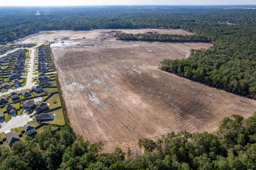
Today, Royal Pines looks vastly different from the way it did last April. If such a thing as “truth in development naming” existed, they would have to call it “The Barrens of Kingwood.”
I first reported on the clearing of 200+ acres for this new development back in April 2022.
Now see the four photos below taken from different angles on 10.31.22.
Looking NE from Porter across the barrens.Looking SE.The only thing taller than tire ruts are some piles of mulch that still need to be hauled away.Looking West from near White Oak Creek. Country Colony on left.Looking West from entrance.
Royal Pines bought the land from the 1992 Guniganti Credit Shelter Trusts on 12/9/21. The Guniganti family owns the Triple PG sand mine east of the area being cleared. You can see it in the background of the first two photos above.
The plan above shows that 80+ homes are in the pre-Atlas-14, 100-year floodplain. Six are in areas LOWER than the 100-year flood plain.
Use of old flood-plain maps could put unsuspecting buyers at risk. The flood plain maps for this area were last updated in 2014. New Atlas 14 maps may not become official for several more years…potentially after this developer starts selling homes.
The thoughts expressed in this post represent opinions on matters of public concern and safety. They are protected by the First Amendment of the US Constitution and the Anti-SLAPP Statute of the Great State of Texas.
https://i0.wp.com/reduceflooding.com/wp-content/uploads/2022/11/20221031-DJI_0079.jpg?fit=1200%2C799&ssl=17991200adminadmin2022-11-02 10:36:292022-11-02 16:58:10From Lush Forest to Pine Barrens in 7 Months
Harris County Flood Control District (HCFCD) says that, as of 10/31/22, Sprint Sand and Clay has hauled off 66,094 cubic yards of dirt from Woodridge Village. That means, despite the slowing real estate market, that the company has exceeded its Excavation and Removal contract minimum within nine months of the first year.
Objective of Excavation
The objective of the contract: to get a head start on the removal of up to 500,000 cubic yards of dirt from what will eventually become the sixth stormwater detention basin on the Woodridge Village property. Woodridge forms the headwaters of Taylor Gully.
Community Meeting Will Reveal Findings of Engineering Study
HCFCD is now planning a community meeting to share the results with affected residents before the end of the year.
It’s not clear yet exactly:
How much additional detention Woodridge will need
How much channel widening Taylor Gully will need
Whether any bridges need to be replaced
How upstream improvements will affect residents farther downstream.
The preliminary engineering report should address all those questions.
Photos from September and October
In the meantime, a parade of dump trucks visits the Woodridge site most days to haul off dirt from where the sixth basin will go. The sixth basin could double stormwater detention capacity on the site – if Sprint excavates all 500,000 CY.
Sprint’s contract calls for them to remove a minimum of 60,000 cubic yards per year or 5,000 per month.
The September and October pictures below show how far Sprint has come in the last six weeks.
End of September 2022End of October.Sprint has not gone much farther, but they have gone deeper.
See pictures taken below from the reverse angle. The majority of the work now takes place at the far end.
Extent of excavation on September 24.End of October 2022.
Groundwater appears to be seeping into excavated areas.
HCFCD did not confirm WHY Sprint appears to be digging shallower. Amy Stone, a HCFCD spokesperson, did say however that the site contains multiple types of soil. The volume removed in a particular location may relate to demand for a particular type.
More news about the community meeting and study findings when it becomes available.
Posted by Bob Rehak on November 1, 2022
1890 Days since Hurricane Harvey
https://i0.wp.com/reduceflooding.com/wp-content/uploads/2022/11/20221031-DJI_0038.jpg?fit=1200%2C799&ssl=17991200adminadmin2022-11-01 13:00:172022-11-02 14:38:13Woodridge Village Excavation, Taylor Gully Updates
This follows an approval on June 28 to spend $85 million on 16 projects. Two thirds of the benefit for those also went to Precincts 1 and 2.
Not one of the 20 projects approved to date is in the San Jacinto Watershed.
Where the Money Went
Of the four flood-mitigation projects approved for trust funding in October, three were in the Halls Bayou Watershed and one was in Sims.
In June, commissioners approved 16 other projects:
One in the Armand Bayou watershed
One in Brays
Two in White Oak
Three in Halls
Four in Greens
Four in Cypress and Little Cypress Creeks
One in Buffalo Bayou
Of the 16 projects, 14 benefited Precincts 1 and 2, but only 7 benefited Precincts 3 or 4. The totals for “projects” and “areas benefited” do not equal because sometimes benefits cross precinct boundaries.
Looking at both groups of expenditures, 20 benefited Precincts 1 and 2, while only 7 benefited Precincts 3 or 4. So about one quarter of the flood mitigation benefit has gone to the Republican-leaning half of the county.
Purpose of the Trust
The Flood Resilience Trust Fund was originally conceived to facilitate:
Acceptance of a grant that requires a local match exceeding secured local funds
Awarding construction projects that exceed the amount of secured funds
A change in contract for a construction project underway that exceeds the amount of secured funds
In all of the most recent cases, the expenditures avoided delays for projects already underway. In each, partnership funds did not materialize as expected. See below.
Polls are open from 7 A.M. to 7 P.M. Monday through Friday this week for early voting. Election Day is on November 8. It’s a long ballot. Make sure you vote all the way to the end, because several key races/proposals are hidden in the middle of all the judicial races. For instance, the race between Lina Hidalgo and Alexandra Mealer for County Judge comes after family court judges on the ballot.
All registered voters in Harris County may vote for County Judge. A heavy turnout in this area could swing the election. It’s close. As of this morning, however, fewer than 10,000 people in Kingwood have voted.
Also, Precincts 2 and 4 will elect Commissioners this year. (The Lake Houston Area is now in Precinct 3 and won’t vote for commissioner until 2024.)
There are also three county bond proposals on the ballot totaling $1.2 billion being pushed by Precinct 2 Commissioner Adrian Garcia. Despite promises made by the County Administrator months ago, none has a defined project yet, so if you approve the Garcia Bonds, you’re writing a blank check.
That echoes lopsided Flood Resilience Trust and 2018 Flood Bond spending to date. Don’t miss your chance to bring fiscal control and balance back to Commissioners Court. And some flood-mitigation benefits to the Lake Houston Area.
Posted by Bob Rehak on 10/31/22
1889 Days since Hurricane Harvey
https://i0.wp.com/reduceflooding.com/wp-content/uploads/2022/10/20221031-Screenshot-2022-10-31-at-11.07.25-AM.jpg?fit=1200%2C616&ssl=16161200adminadmin2022-10-31 11:42:432022-10-31 12:47:25County Approves Another $15 Million for Flood Mitigation in Precincts 1, 2
Ever wonder how to find the depth of flooding on a bayou, river or stream near you? Here’s a simple way. But this only works for those in and around Harris County, Texas, and those who live on streams with gages.
FWS stands for Flood Warning System. The main function of this website is to alert you when streams are in danger of coming out of their banks. But the site also shows historical information for dozens of gages that blanket Harris and surrounding counties. That information includes flood peaks and bank elevations. By subtracting the bank elevation from the peak, you can easily determine the height of a flood and compare the height in your area to other areas.
For this exercise, start by selecting ALL gages in the left column. Gages across the region will pop up. See below.
By default, the map shows how much rainfall all those gages received in the last 24 hours. But there’s much more information behind them. Next…
Click on Any Gage
Another box pops up that is the gateway to historical information about that location. In this example, I clicked on the gage at the San Jacinto West Fork and US59.
Click on the hyperlink that says, “More information and alert signup.” Then, in the next screen…
Click on the Stream Elevation Tab
Scroll Down
You should see a box that looks like the one below.
The red “Flooding Likely” line represents the top of bank in that area. They say “Likely” because bank heights may vary slightly around a gage. But for most locations in a flat area like ours, that’s the point at which water starts to come out of the banks. Near this gage, the river starts coming out at 49.33 feet above sea level.
Below that box, three more boxes show:
Gage readings during the current time period (or any historical time period if you specify one).
Flood frequency for that gage location. For instance, the height of a 10-, 50-, 100- or 500-year flood.
Historical records for major storms.
This last box contains the information you want (if you’re looking for the Harvey peak). For instance, you can see that at this location, the West Fork reached 69.6 feet.
Subtract Flooding-Likely Elevation from the Flood Height
Subtracting the flooding-likely elevation from the high-water mark tells you the depth of flooding, i.e., how high the water got above the banks. At this location, that was more than 20 feet! (69.6 minus 49.33)
Step and Repeat
To compare the depth of flooding at other locations, repeat the same process. To visualize the differences, it helps to develop a spreadsheet with four columns: Location, Flooding Likely, Peak, Difference. Then you can then easily create a graph that looks like the one below.
Chart showing feet above flood stage at 33 gages during Harvey.
In this case, you can see that the San Jacinto, Spring and Cypress Creeks had the deepest floodwaters in the northern part of the county during Harvey. Some gages at other locations show that water didn’t even come out of banks.
What About Minor Floods?
The Harris County Flood Warning System contains information about stream levels going back 20+ years. If you’re looking for information about a flood not shown in the Historical Record box, you can search for it by specifying a time period and date range above the stream elevation and rainfall tabs.
Caution
Usually, Harris County Flood Control District personnel manually verify the historical records. So, you can trust the information. But if you’re researching smaller floods by inputting your own dates and time periods in the search fields, you may run into a problem.
Before 2010, sometimes gages recorded faulty readings. Gages during that period used pressure transducers, which could clog with floating debris and report false information.
So, if you see a hundred-foot flood that lasted 15 minutes, you’re looking at error. Cross check such readings against rainfall at the same gage. Also, check the readings immediately up- and downstream to rule out spurious readings.
The graph above shows wide ranges in the depth of flooding on the same bayous. Don’t assume that because a flood was 20 feet deep at one location that it will be the same along the entire stream. The topography could narrow, widen, deepen or flatten. All could affect the depth of flooding. So could other factors, such as the amount of surrounding development or previous flood mitigation efforts in an area.
Identifying Causes of Flooding
Using information from the Flood Warning System, you can help narrow down the source of flooding. If a neighborhood flooded, but the channel didn’t come out of its banks, you’re looking at a street-flooding issue. Most storm sewers and roadside ditches in Harris County and Houston are sized to handle a two-year rain. But older ones may have only a one-year level of service. And many become clogged over time. See below.
For More Information
To learn how to find and verify other flood-related information, make sure you check out this post.
Posted by Bob Rehak on 10/29/22with thanks to the Harris County Flood Control District
1887 Days since Hurricane Harvey
https://i0.wp.com/reduceflooding.com/wp-content/uploads/2022/10/20221029-Screenshot-2022-10-29-at-8.22.46-PM.jpg?fit=1200%2C715&ssl=17151200adminadmin2022-10-29 21:19:072022-10-30 09:13:19Simple Way to Find Depth of Flooding Near You
This morning’s 7 a.m. report from Jeff Lindner, Harris County’s meteorologist, indicates that the severe weather threat predicted yesterday for Houston has shifted southwest toward Matagorda Bay and offshore. However, showers and thunderstorms will increase through the day. And few of the storms could be strong to severe.
Radar Image Shows Gap Between Storms at 11 AM
Radar images at 11 a.m. confirm that two major storms will not converge where predicted yesterday.
RadarScope image shows storms predicted yesterday to converge over Houston have diverged.
Activity along the coast should move eastward this morning while a second line of storms moves from central Texas toward Houston. The offshore warm front did not move as far inland as expected overnight.
Tornado Threat Limited, But Hail Possible
Lindner thinks the severe weather and tornado threat to the Houston area is fairly limited today, although the cooling of the air column may result in the threat for some hail with lingering storms into the evening hours.
Additional showers will develop ahead of this main line, but concerns yesterday for supercell structures appear lower today and confined to Matagorda, Jackson, Wharton, and Calhoun Counties.
Lindner now expects rainfall of 1-2 inches over the Houston area. Given current drought conditions, it is much needed.
Rainfall rates offshore have averaged 2-4 inches per hour, but that storm should remain offshore, he says.
The main line of approaching weather should clear the Houston region by 4:00 p.m., but areas north of I-10 could see additional showers and thunderstorms into the evening hours.
A few light rain showers or drizzle east of I-45 may linger into Saturday. This coupled with cold air advection and north winds of 10-15mph may lock temperatures in the upper 50’s/low 60’s on Saturday. However, where the clouds are able to clear, temperatures will warm into the mid 70’s. We could see significant differences in temperature over a short distance.
Skies should clear Saturday night into Sunday with cool conditions in place for a mild and dry Halloween.
Posted by Bob Rehak on 10/28/22 based on reports from the NWS and Harris County
1886 Days since Hurricane Harvey
https://i0.wp.com/reduceflooding.com/wp-content/uploads/2022/10/Screenshot-2022-10-28-at-10.54.42-AM.jpg?fit=1125%2C2200&ssl=122001125adminadmin2022-10-28 12:02:342022-10-28 12:02:41Highest Risk for Severe Weather Shifts SW and Offshore