Tag Archive for: Colony Ridge

Recommendations for Special Session of Texas Legislature on Colony Ridge

Today, the Texas legislature began another special session. On the agenda: Colony Ridge, the controversial Liberty County development in so many headlines lately.

Colony Ridge
Colony Ridge, the world’s largest trailer park, now covers approximately 20,000 acres, an area 50% larger than Manhattan.

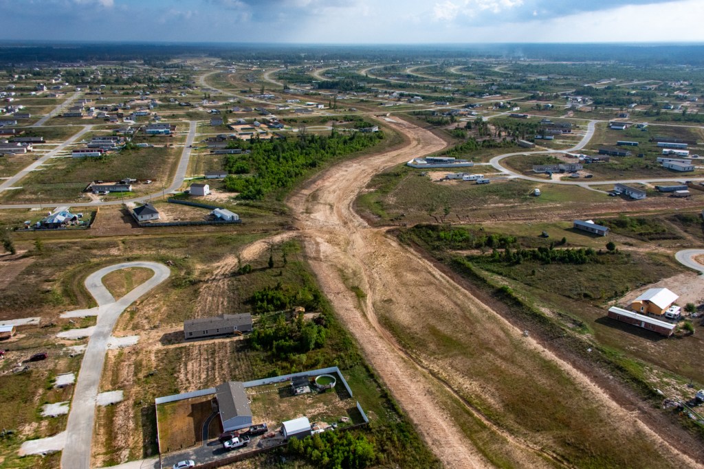
During the last four years, I have published more than 60 articles about Colony Ridge. I have based them on countless drive throughs, flyovers, and interviews with residents, engineers and public officials.

I have seen with my own eyes, over and over again, many drainage and related infrastructure issues that the state legislature could address. In my opinion, the legislature should address the following.

Please forward this link to all your friends. Ask them to contact their state legislators in support of these recommendations.

List of Infrastructure Recommendations for Special Session

  • Get Liberty County to enforce its drainage regulations.
  • Protect downstream areas from Colony Ridge erosion by forcing the developer to comply with Liberty County regulations, including those that call for:
    • Planting grass on the side slopes of drainage channels and stormwater detention basins
    • Installing backslope interceptor swales and pipes to protect side slopes from sheet flow that causes erosion
    • Installing pilot channels along the bottom of detention basins
  • Tell TxDoT to fix FM1010, a vital evacuation route for tens of thousands of people.
  • Update state building codes to reduce squalor and make Texas eligible for more than a billion in FEMA BRIC funding which could help address Colony Ridge infrastructure issues.
  • Put teeth into the State Water Code Section 11.086 to ensure Colony Ridge and others provide adequate stormwater detention that helps protect downstream residents from flooding.
  • Create minimum drainage standards that:
    • Mandate use of Atlas 14 or latest FEMA rainfall rates
    • Require minimum detention rates of .55 acre feet per acre
    • Prohibit use of hydrograph timing surveys
    • Require “No net fill in current mapped 500-year floodplain”
    • Require minimum finished floor elevations of new structures above the 500-year flood elevation
  • Protect wetlands
  • Stiffen penalties for discharging sewage into waterways and ditches.

In addition, the state should:

  • Require local governments to preserve records and comply with TPIA/FOIA requests.
  • Prohibit “insider” business deals between elected/appointed officials and developers.

In regard to insider business deals, one of the Colony Ridge developers who controls the local MMD proposed giving a contract for almost $10 million to a paving company controlled by his family. I’m told the final figure actually approved was closer to $15 million. Shouldn’t the developer be responsible for that?

Why We Need Action

Everybody is downstream from somebody else. Or they will be someday. The purpose of the legislature is to develop rules that enable us all to live safely together. Colony Ridge issues affect people both upstream and downstream.

Downstream Impact

Downstream residents have had to pay tens of millions of dollars for dredging sediment in the San Jacinto River. Much of that sediment was contributed by Colony Ridge.

That sediment also contributed to flooding thousands of homes when it blocked the river.

Finally, the City of Houston is spending $1.77 billion dollars to build a water treatment plant that removes sediment and other pollutants coming into Lake Houston from Colony Ridge and places like it. And we spent another $381 million on the Luce Bayou Interbasin Transfer Project to bring in water from the Trinity River.

So, we are spending more than $2.1 billion to bring in and clean up water that Colony Ridge is polluting. Stop the treadmill! Please!

Upstream Issues

Colony Ridge and Plum Grove residents have suffered, too. In addition to the drainage issues described in previous posts, here is a list of other infrastructure issues that a Colony Ridge property owner sent me:

  • Emergency evacuation routes limited and congested. Few ways in or out.
  • No street lights in most of the development.
  • No sidewalks
  • Kids are waiting for school buses on unlit street corners 
  • Aggressive dogs attack people when walking in the streets 
  • Minimal fire hydrants for our area
  • Cement plants in our neighborhood spew silica dust for miles without TCEQ or EPA permits
  • No school zone lights for school in Santa Fe 
  • Kids have no safe place to play outside due to unlawful discharge of firearms
  • Major traffic congestion; situation deteriorating 
  • Ambulances have trouble getting into area and back out to a hospital
  • Many missing street signs for traffic control (stop, yield, school zone, etc.)

Both Developer and Legislature Under a Microscope

It will be interesting to see whether the legislature actually does anything substantive about the infrastructure issues in Colony Ridge or whether they just deport a few people, declare a symbolic victory and continue accepting donations from the developer. Let’s be positive for now. Who thought things would ever get this far?!!!

Posted by Bob Rehak on 10/9/2023

2232 Days since Hurricane Harvey

The thoughts expressed in this post represent opinions on matters of public concern and safety. They are protected by the First Amendment of the US Constitution and the Anti-SLAPP Statute of the Great State of Texas.

Karma Strikes Again: Colony Ridge Drainage Systems Severely Eroding

October 8, 2023 – Karma is fast catching up with the corner-cutting Colony Ridge developer in Liberty County. Drainage infrastructure that doesn’t meet Liberty County regulations is fast eroding.

And tomorrow, a special session of the Texas legislature will start investigating the embattled development. The special session will focus on crime, infrastructure, illegal immigration, and more.

To offset negative publicity, the developer invited legislators to meet at his development last week and tour it.

But just before the meeting, Liberty County deputies, a narcotics unit, and SWAT team responded to an abduction at gunpoint. They also launched a manhunt for two escaped suspects in the sprawling development, which is now 50% larger than Manhattan.

On the day of the developer’s meeting, the main entrance to the development flooded. Badly. Ditches designed to keep roads clear in a 5-year storm overflowed during a 1-year rain.

The next day when the storm clouds cleared, an aerial survey showed that Colony Ridge drainage channels and stormwater detention basins were badly damaged.

Had the developer simply followed Liberty County regulations, he could have reduced or avoided the costly damage.

Missing Erosion Controls

Section 50 of Liberty County’s Subdivision and Development regulations specifies requirements for construction of drainage ditches and stormwater detention basins.

The County emphasizes the need to control erosion and sedimentation. It warns these twin threats can have very serious effects on stormwater ditches and basins. Specifically, they can:

  • Cause slope failures
  • Reduce the efficiency of drainage channels
  • Clog drainage culverts
  • Reduce channel capacity
  • Reduce maintainability of drainage facilities
  • Increase maintenance costs
  • Require more frequent repairs
  • Increase turbidity
  • Impair water quality.

To counter these problems, the regulations say…

“Interceptor structures and backslope swale systems are required to prevent sheet flows from eroding the side slopes of open channels and detention facilities.”

Liberty County Subdivision and Development Regulations, Page 100

The diagram below explains how they work.

backslope interceptor design

The regulations also specify design requirements for these structures and other erosion control measures. Altogether, Colony Ridge apparently violated requirements for:

  • Backslope interceptor and swale systems
  • Bermuda grass on side slopes of channels and ditches
  • Erosion controls around outfall pipes
  • Geo-textile bedding under rip rap
  • Pilot channels at the bottom of detention basins
  • Maintenance strips
  • Storage of excavated dirt
  • Side-slope angles

Not all locations in Colony Ridge exhibit all problems. Regardless, karma was swift. Thursday’s 1-year rain severely eroded the side slopes of channels and basins. Eroded sediment also started filling in new ditches and basins.

Repairs and compliance – if attempted – will be costly and time consuming.

Karma Hurts Residents Upstream and Down

While critics might rejoice at the karma, others will pay the price. The developer’s practices increase flood risk for people in Colony Ridge as well as those downstream.

  • In the development, erosion threatens property.
  • Downstream, sediment reduces the conveyance of streams, increasing flood risk.

TCEQ has warned the developer about his construction practices before. But many dubious practices continue. See photos below.

The first two are NASA satellite images from Google Earth. I shot the rest on 10/6/23 with one exception.

Threat to Colony Ridge Residents

When a three-mile ditch down the center of Colony Ridge was completed, it was about 120 feet wide at the yellow line.

August 2017

Today, it’s 76 feet wider.

Residents on EACH side lost 38 feet of their back yards.

This ditch has steadily widened since its construction. Without backslope interceptor swales or grass to reduce erosion, millions of cubic feet of dirt swept downstream from this single ditch.

Then, when the water slowed at the headwaters of Lake Houston, the sediment dropped out of suspension, reducing the conveyance of the East Fork San Jacinto.

Here are several shots showing what that erosion damage looks like up close from a helicopter.

The ravine forms more ravines.
No room for a maintenance road here.
Or here.

Virtually every ditch in Colony Ridge has erosion and compliance problems. Here’s another one.

No maintenance road. No backslope interceptor swales. No grass on sides of ditch. Note: home on right has no back fence. What happened to it?
Note piles of dirt stored where they can erode back down into ditches.

Even detention basins in the newer sections of Colony Ridge have erosion problems. Again, most don’t have grass on the side slopes. Nor do they have backslope interceptor swales. Many, like the one below, don’t have room for maintenance roads.

Note the erosion threat already to these recently placed mobile homes in a newer section of Colony Ridge.
Erosion will soon threaten one of the new roads in Colony Ridge. Regs specify that rip rap like you see here should have had a geo-textile lining under it to reduce erosion.
Erosion washed sediment into new basin. Also note how erosion is starting to block the outfall at the lower right.
No backslope swales here. Not much Bermuda grass either. Regs say “side slopes shall be no steeper than 3 horizontal to 1 vertical (3:1).”
No grass or backslope interceptor system here. No pilot channels either.
Note piles of excavated dirt stacked on both sides of road, eroding back into ditches.

As all those ditches and basins gradually fill in, they will add to future flood risk.

But repairing such issues will be a big, costly challenge – one that the developer has ignored for years.

Threat to Downstream Residents

All this erosion also contributes to downstream flooding and likely violates Section 11.086 of the Texas water code. It states that “No person may divert … the natural flow of surface waters in this state … in a manner that damages the property of another…”

Where does all that eroded sediment eventually go? To Lake Houston, of course.

East Fork San Jacinto downstream from Colony Ridge on Thursday 10/5/23 – same day as shots above.

The river slows down where it meets the headwaters of Lake Houston. That causes sediment to drop out of suspension.

Harris County, City of Houston and the State just finished a major dredging effort on the East Fork that cost the public tens of millions of dollars.

Before dredging, it looked like this.

East Fork Mouth Bar after Imelda and before dredging. This bar grew 4,000 feet between Harvey and Imelda.

But the cost is only part of the issue. Reduction in the river’s conveyance contributed to the flooding of thousands of nearby homes during Harvey and Imelda.

Harris County Commissioners Court May Address Issues on Tuesday

Drainage is a public-safety issue. And it’s not the only one caused by the developer’s disregard for regulations.

  • Colony Ridge has filled in wetlands.
  • TCEQ has also documented problems with the Colony Ridge sewage system that led to a 48,000 gallons of fecal matter escaping into Lake Houston, the source of drinking water for 2 million people.
  • Colony Ridge does not have enough fire hydrants or water pressure to comply with the Liberty County fire code.

Harris County Commissioners Court may discuss these problems on Tuesday at the request of Precinct 3 Commissioner Tom Ramsey, PE. See Item 406 on the Agenda.

The developer alleges that racism motivates criticism of his Hispanic development. But racism does not explain flooding, feces and fire.

The failure of a developer to follow regulations shouldn’t pit Liberty County against Harris County, rich against poor, or Democrats against Republicans.

We all suffer equally. We all face increased risk. And Colony Ridge is one issue where we should all find common cause.

I hope that Commissioners Courts in both counties support the legislature’s investigation into Colony Ridge. I also pray that both Counties can work together to protect all residents.

Posted by Bob Rehak on 10/8/23

2231 Days since Hurricane Harvey

The thoughts expressed in this post represent opinions on matters of public concern and safety. They are protected by the First Amendment of the US Constitution and the Anti-SLAPP Statute of the Great State of Texas.

New York Post Publishes Gripping Exposé on Colony Ridge

Dana Kennedy of the New York Post published a 2,500-word exposé on Colony Ridge titled “Murders, cartels, squalor: Inside ‘colony’ near Houston accused of being ‘haven for illegal aliens.’”

Kennedy spent weeks researching and writing the article. She interviewed the developer as well as residents, neighbors, local officials and law enforcement. Her story includes 27 photos and a 10-minute video – rare for a daily newspaper. If you really want to get a feeling for Colony Ridge and its impact on surrounding areas, Kennedy’s article is a great place to start.

Summary Of Exposé

She delves into the development’s housing, population, criminal activity, drug cartels, roving dogs, gang activity, access issues and how it has become a magnet for illegal immigration.

In short, she covers why Governor Greg Abbott is making it part of a special legislative session that he called for next Monday. And why Texas’s 25 House Republicans have unanimously called for an investigation.

Kennedy then segues into how the developer markets the property to Hispanics, i.e., with owner financing, small down payments, and interest rates up to 15%. She also details the high foreclosure rates and the revolving door at the county courthouse that allows the developer to resell the same property multiple times.

From there, she turns her attention to the impacts on surrounding communities – homes flooded, FM1010 washed out, endless traffic snarls, a severed human hand that a dog dragged home, and plummeting property values. She lets disenchanted purchasers and neighbors tell their stories in their own words.

Developers Claim of Racism Disputed

The developer blames the criticism on racism among the locals. Former Plum Grove Mayor Lee Ann Penton-Walker disputes that. “We don’t have the infrastructure to take on all these new people. Hell, Houston doesn’t. New York doesn’t. Look what your mayor’s been saying lately. Is Eric Adams a racist?”

The developer’s claim of racism belies the fact that most of the criticism in the story came from Hispanics.

Kennedy ends her expose with some quotes from me about conditions “hazardous to human health.” They referred to TCEQ reports documenting sewage spills and poorly mitigated drainage.

How the Other Half Lives

All told, it’s a gripping story and a solid piece of journalism. It reminded me of the work done by a pioneering photojournalist in New York named Jacob Riis. He documented living conditions in New York City slums during the 1880s. Riis published a book called “How the Other Half Lives.” It served as a basis for future muckraking journalism by exposing the slums in New York to the City’s upper and middle classes.

I hope Kennedy’s work for the Post has a similar impact and brings Colony Ridge to national attention. Even more, I hope it brings about some much needed change.

Just hours after the Post published Kennedy’s story, the developers launched a PR counter-offensive. They hosted a tour of Colony Ridge for state legislators who will begin their investigation into the controversial development next week during their special session.

The address below probably won’t be on the PR tour.

Remnants of an American dream, thanks in part to the scarcity of fire hydrants in Colony Ridge.

For more about Colony Ridge drainage and related infrastructure issues, see these posts.

Posted by Bob Rehak on 10/5/2023

2228 days since Hurricane Harvey

The thoughts expressed in this post represent opinions on matters of public concern and safety. They are protected by the First Amendment of the US Constitution and the Anti-SLAPP Statute of the Great State of Texas.

Entire Texas Republican Congressional Delegation Urges Abbott, Paxton to Investigate Colony Ridge

A letter dated September 30, 2023, and signed by all 25 members of the Texas Republican Congressional delegation urged Gov. Greg Abbott and Attorney General Ken Paxton to investigate numerous allegations related to Colony Ridge in an upcoming special session of the Texas Legislature. The Colony Ridge developer has already launched a charm offensive designed to defeat what it calls “scurrilous rumors and lies.”

Congressional Letter Suggests Scope of Investigation

The controversial Liberty County development has drawn media attention dating back to at least 2015. The letter by Texas Congressional Republicans refers to many of those. Allegations in the letter include:

  • “Owner-financed loans with no credit check or proof of legal residency, making the location an optimal haven for illegal aliens amid a historic border crisis.”
  • Public safety concerns, including creating a “no-go zone” for law enforcement
  • Sewage spills
  • Fecal contamination in drainage ditches
  • Significant erosion in drainage ditches leading to increased risk of downstream flooding
  • Adverse effects on neighboring communities
  • Unsuccessful local attempts to remediate issues
  • Lack of fire hydrants
  • Improvised living conditions
  • Water, power and flooding issues
  • Violent crime including several high profile murders
  • The largest drug busts in the history of Liberty County
  • Drug cartel activity
  • Overwhelming the Cleveland ISD with “thousands of illegal aliens.”

The letter concludes with:

  • A list of things that the Congressional Republicans have fought for at the federal level to make America secure.
  • A request for Abbott and Paxton to share the results of their investigations with Congress.
  • An offer to assist the state.

Since media attention to Colony Ridge has mushroomed, claims like those above have become harder and harder to brush off – especially in an election year, when Republicans have framed illegal immigration as a core issue.

To see the full, six-page, footnoted letter, click here.

Will Investigation be Instant Replay of Paxton Impeachment Trial?

Ironically, Paxton’s office will theoretically do the investigating. His recent impeachment trial centered around his relationship with a developer (but not this one). It will be interesting to see how/whether that affects this investigation. Only one thing is certain: Paxton, Abbott and Colony Ridge will be under a national spotlight.

Colony Ridge Developer Launches Charm Campaign

The developer also released a letter, one day ahead of the Congressional letter. (See below.) It calls the allegations “salacious lies and rumors.” It offered to give members of the Texas legislature tours of Colony Ridge in advance of the upcoming special session. I’m sure the tours will be heavily curated. For instance, I doubt they will:

  • Go down streets with horrific living conditions
  • Highlight their lack of fire hydrants
  • Show off sewage spills
  • Point out the bridge they blew out on FM1010
  • Highlight the repossession rate of property (I talked to one owner of a new lot who was the fourth owner.)
  • Tour eroded channels (that would require maintenance roads at a minimum).

Here’s the Colony Ridge letter.

Notice that the developer’s letter does NOT deny drainage problems.

Complies with All Regulations? Really???

I was not invited to the developer’s party. But any member of the Texas legislature who wants to see whether they comply with Liberty County regulations can consult these posts.

When I first started exploring Colony Ridge, I learned that Liberty County did not have construction plans, nor required drainage studies for many Colony Ridge subdivisions. And those that the County could supply underestimated the runoff from Colony Ridge by misrepresenting the soil types found there. The extra runoff blew out FM1010 which remains unrepaired as of this writing.

Colony Ridge also failed to meet fire-hydrant spacing and pressure requirements in the Liberty County Fire Code. I have ten fire hydrants on my block. At last count, Colony Ridge had 59 in an area 50% larger than Manhattan.

If you want to see an example of their “fully engineered” sewers, see this post. But hold your nose.

This post explores more Colony Ridge issues and impacts…

Posted by Bob Rehak on October 1, 2023

2224 Days since Hurricane Harvey

The thoughts expressed in this post represent opinions on matters of public concern and safety. They are protected by the First Amendment of the US Constitution and the Anti-SLAPP Statute of the Great State of Texas.

GIS Data Reveals Likely Source of NE Houston Flooding Unrelated to Historic Disinvestment

In northeast Houston, where residents and activists frequently chant “historic disinvestment,” I accidentally stumbled onto a much more likely cause of the frequent flooding than systemic racism. It happened while browsing a GIS database with hundreds of layers containing a broad range of information. The instant I saw it, it unlocked a mystery. Tumblers suddenly aligned that unlocked the mystery. But let’s start this story with accusations that made no sense to me.

Accusations of Systemic Racism Not Supported by Spending Data

Three years ago, I joined the Harris County Community Flood Resilience Task Force. Ever since, I have heard a constant drumbeat of “historic disinvestment” by many members who believe they are victims of systemic racism by Harris County Flood Control District (HCFCD).

They claim that they aren’t getting their fair share of flood-mitigation funds when, in fact, financial analysis reveals the opposite. They get the lion’s share.

LMI vs. Non-LMI flood-mitigation funding
LMI vs. Non-LMI flood-mitigation funding through Q3 2021.

Eight watersheds with a majority of low-to-moderate income residents have received almost two thirds of the funding going back to 2000. That’s out of a total of 23 watersheds. The money has flowed to damage – as it should.

Many people, however, don’t believe that. The loudest complaints have come from the Northeast Action Collective. They waged a battle to remove flood-control executives from office who were working tirelessly on their behalf.

Regardless, falsehoods repeated often enough eventually rose to the level of “accepted truth.” Even experts can be fooled. Jim Blackburn, the renowned professor of engineering at Rice, repeated the “historic disinvestment” claim without presenting any proof in a Houston Chronicle story last week.

He claimed residents of Halls and Greens Bayou watersheds weren’t getting their “fair share” of flood mitigation money. In fact, Greens Bayou ranks #2 in terms of money received. Only Brays Bayou has received more.

Spending by Watershed from 2000 through 2023Q1. Source: Harris County Flood Control District via FOIA request.

And tiny Halls Bayou ranks #2 in spending per capita. Together, the two bayous have received more than $390 million to date.

And they could soon receive another $466 million out of the $750 million that the GLO and HUD recently granted Harris County for flood mitigation. If HUD approves the recommended projects totaling $466 million, Halls and Greens will have received $856 million – far more than any other watershed. (Technically Halls is a sub-watershed of Greens, but HCFCD tracks spending as if it were separate.) This is hardly historic disinvestment.

More Likely Cause of Flooding Overlooked by Critics Crying Racism

Today, while learning a new (to me) geographic information system, I randomly clicked on a “wetland” layer. Boom! Guess where the largest concentration of wetlands in Harris County is. The northeast!

Note Lake Houston in the upper right, once home to untold acres of wetlands before the dam was built in the 1950s.

As a reminder of what these wetlands once looked like, see the photos of Emily Murphy who kayaks along the shores of Lake Houston.

Emily Murphy wetland photo by Lake Houston
Photo Courtesy of Emily Murphy

Regulations discourage building in wetlands for good reasons. Water collects there. The soil is less permeable. They are low, poorly drained, and unstable.

In addition, USGS points out the many positive benefits of wetlands. “Wetlands provide habitat for thousands of species of aquatic and terrestrial plants and animals. Wetlands are valuable for flood protection, water quality improvement, shoreline erosion control, natural products, recreation, and aesthetics.”

But because they’re cheap land and available, some less-than-scrupulous developers often try to build in them. I’m told by engineers I trust that that has always been the case and always will be.

Back in the 1950s, farms and ranches occupied most of the northeast Houston area. Here’s what it looked like then.

Note the San Jacinto River in the upper right in this 1953 pre-Lake Houston aerial image from Google Earth.

And here’s what the same area looks like today.

Note the presence of Lake Houston in the upper right in this 2022 image.

There are still big undeveloped areas in the image above. But many developments have also filled in large parts of the northeast that were once wetlands in the 1950s image.

Dangers of Building Over Wetlands

According to USGS, “Wetlands are transitional areas, sandwiched between permanently flooded deepwater environments and well-drained uplands, where the water table is usually at or near the surface or the land… The single feature that most wetlands share is soil or substrate that is at least periodically saturated with or covered by water.”

Wetlands are almost always terrible places to build houses.

Four years ago, I posted about the disadvantages of building over wetlands. Pictures of the Woodridge Village property, then under development by Perry Homes, dramatized how unstable the soils were. Dangers of building over wetlands include shifting slabs, cracked driveways, mold, erosion, clogged storm drains, flooding and more.

Unsuspecting buyers of former wetlands can literally get sucked in by low prices. Seventy years later, the original builders and buyers are long gone. And pre-digital soil samples and drainage analyses (if they were ever done) have long since disappeared into the fog of history or a dusty warehouse.

Wetland-mitigation banks near a development should raise red flags to buyers today. There’s one on the northeast corner of Beltway 8 along, you guessed it, Greens Bayou. There are also two in Colony Ridge: the Houston-Conroe and Tarkington Bayou Mitigation Banks.

In conclusion…

Today’s residents in such areas pay for previous owners’ lack of knowledge – not because of historic disinvestment.

I’m not saying early owners didn’t exercise due diligence. We just didn’t know then what we know now.

Posted by Bob Rehak on 9/22/23

2215 Days since Hurricane Harvey

The thoughts expressed in this post represent opinions on matters of public concern and safety. They are protected by the First Amendment of the US Constitution and the Anti-SLAPP Statute of the Great State of Texas.

History of Heartbreak: A Colony Ridge Chronicle

I wrote my first post about Colony Ridge in May 2020. Since then, I have written more than 75 about the controversial, Liberty County colonia that’s now 50% larger than Manhattan. Virtually all of them cover aspects of drainage, wetlands and flooding, as well as the development’s impact on people, the environment and surrounding areas.

The articles also include stories on surrounding developments by the same developer, but operating under different names. But you do not need those to support the 50% larger calculation above.

I’m listing all of my Colony-Ridge-related stories here to make them easier for readers to find.

Colonia Now Drawing National Attention

During the past 3+ years, the growth of Colony Ridge, an unincorporated development, has overwhelmed smaller incorporated areas around it such as Plum Grove and Cleveland.

As a result, fast-growing Colony Ridge has attracted national attention by numerous journalists, not all of it welcomed by the developer. My focus has been almost exclusively on flooding, drainage and water quality issues. Other journalists have focused on crime, cartels, drugs, illegal immigration, overwhelmed schools, predatory lending practices, evictions, the marketing practices of the developer and more.

Here is a list of the drainage related articles. I’ve also taken thousands of pictures – far too many to insert them all here. But I have included a few. See more when you follow the links below.

2020

Colony Ridge erosion
Due to failure to follow drainage regulations, erosion is eating people’s yards. Note gap under new fence.

May 3, 2020 Development Watchlist: Perry, Romerica, Colony Ridge and More

June 14, 2020 Rapid Runoff from World’s Largest Trailer Park Wipes Out Plum Grove Road in Liberty County and More

June 15, 2020 World’s Largest Trailer Park Has Only a Handful of Fire Hydrants

June 19, 2020 “The Developers Are Coming! The Developers Are Coming!”

June 23, 2020 48,000 Gallons of Fecal Contamination Found in Liberty County’s Colony Ridge Ditches, Streams; Problems Persist

June 24, 2020 Hidden Cost of Fecal Contamination: Removing It

October 14, 2020 TCEQ Fines Quadvest for 48,000 Gallon Sewage Spill in Colony Ridge

October 15, 2020 Plum Grove Sues Colony Ridge Developer Over Floodwater, Sewage Leaks

October 16, 2020 TCEQ Blasts Colony Ridge, Says Construction Practices Could Adversely Affect Human Health

October 22, 2020 How Loss of Wetlands Led to War

October 25, 2020 New Drone Shots Reveal Need for Better Flood Control in Liberty County

November 12, 2020 Flood Notes: Highlights of Current Happenings

November 20, 2020 Friday Flood Digest

November 27, 2020 Colony Ridge Declares War on Investigative Journalist, Too

December 1, 2020 Flood of Foreclosures: Hundreds to Lose Colony Ridge Homes Tomorrow

December 5, 2020 Colony Ridge Ditches Violate Liberty County Drainage Standards

December 7, 2020 Merry Christmas from Colony Ridge

Merry Christmas from Colony Ridge
I took this shot shortly before Christmas. Poverty in Colony Ridge is heartbreaking. Note the food still on the table. Residents say multiple families often live in such a home.

December 10, 2020 Rivers of Mud: Largest Development in Liberty County Openly Flaunts Drainage Regulations

December 12, 2020 Rivers of Mud, Part Dos: Wayne Dolcefino Uncovers More Liberty County Dirt

December 14, 2020 Liberty County Strategic Plan … Dead On Arrival

December 16, 2020 Liberty County Hazard Mitigation Plan Contains No Mention of Largest, Most Vulnerable Community in County

December 21, 2020 “One of the Best Land Developers in Liberty County”

December 23, 2020 Preserve What Makes Lake Houston Area Unique

December 26, 2020 Colony Ridge Drainage Reports Misrepresent Soil Types, Underestimate Runoff; Many Reports Missing

December 29, 2020 When Developers Claim No Detention Ponds are Necessary…

2021

Colony ridge erosion
Dirt often piled by the sides of ditches erodes back into the ditches and gets carried downstream. There, it can reduce conveyance and must be dredged to control flood risk.

January 2, 2021 Guess Which Way to Colony Ridge

January 3, 2021 Flooding of the Fifth Kind: By Government Neglect

January 4, 2021 Liberty County Launches Major Investigation into Colony Ridge Irregularities

January 10, 2021 New Wetland Mitigation Bank Proposed for Areas Upstream from Lake Houston

January 11, 2021 Thousands of Acres in East Fork, Luce Bayou Watersheds to be Developed as Part of Kingland

January 17, 2021 Rosemay Fain’s Harvey and Imelda Stories

February 1, 2021 Colony Ridge Developer Sues Critics For More Than Million Dollars Based on Questionable Allegations

March 6, 2021 Photo Essay: How “Backslope Interceptors” Reduce Erosion, Ditch Maintenance, Flood Risk

April 23, 2021 Silence: Liberty County, Colony Ridge, Landplan Engineering Remain Mute on Missing Documents

April 25, 2021 Officials Slapped With Criminal Complaints for Failure to Produce Records in Colony Ridge Investigation

May 3, 2021 Rampaging East Fork Floodwaters Cut New Path Through Plum Grove Sand Mine

May 3, 2021 Floodwaters Converging Downstream on Lake Houston

May 4, 2021 Family Trapped For Three Days As Floodwaters Ripped Through Sand Mine, Then Under Their Home

May 27, 2021 State Highway 99 Construction Pushes South, Opening Vast Areas to New Development

June 5, 2021 Eight TCEQ Investigations Reprimand Colony Ridge Construction Practices

June 9, 2021 Follow-ups: Whatever became of…?

June 10, 2021 Colony Ridge Expanding North Into More Wetlands

June 20, 2021 What’s Going On in Your Neighborhood?

July 8, 2021 To Reduce Future Flooding, We Need to Focus on BOTH Mitigation AND Root Causes

July 15, 2021 FM1485: What’s Wrong With This Picture?

July 15, 2021 Town Fighting for Survival Stonewalled By County, State Officials at Every Turn

September 3, 2021 TCEQ Again Cites Colony Ridge for Lack of Pollution Controls

November 16, 2021 Sowing the Seeds of the Next Big Flood

November 29, 2021 How to Find and Verify Flood-Related Information: Part II

December 4, 2021 Grand Parkway Extension is Getting There

December 6, 2021 “…Care Will Be Taken to Protect All Vegetation…”

December 31, 2021 Top Stories of 2021 in Review

Guess which way to colony ridge
Sediment coming down the East Fork from Colony Ridge. From “Guess which way to Colony Ridge.”

2022

Most don’t understand the dangers of living over former wetlands.

January 20, 2022 What Does “No Adverse Impact” Really Mean in Drainage Studies?

February 16, 2022 Texas Land-Use Trends: Major Changes Coming

February 23, 2022 How Soon We Forget!

May 17, 2022 Grand Parkway Extension Opens Tomorrow

July 23, 2022 Controversial Colony Ridge Development Doubles in Size

July 29, 2022 Kingland West Clearing 1,123 Acres at FM1010 and Grand Parkway, Using Old Flood Maps

2023

For those who always dreamed of owning an island home.

May 31, 2023, How a Controversial, Little Understood Definition Affects Flooding

August 4, 2023 Colony Ridge Buying Up Floodplain Land in Huffman

August 13, 2023 Six Years After Harvey, Bridge Still Blown Out at Colony Ridge

August 16, 2023 Colony Ridge Stormwater Detention Basins, Ditches Fail to Meet Liberty County Standards

August 29, 2023 Harvey Flood’s Sixth Anniversary Passes Virtually Unnoticed

August 30, 2023 As Wildfire Weather Sets In, Fastest Growing Area in Liberty County Fails to Meet Fire-Code Requirements

September 9, 2023 Damn the Downstream Consequences, Colony Ridge Expansion Continues Relentlessly

September 17, 2023 Colony Ridge Now 50 Percent Bigger than Manhattan

October 1, 2023 Entire Texas Republican Congressional Delegation Urges Abbott, Paxton to Investigate Colony Ridge

October 5, 2023 New York Post Publishes Gripping Exposé on Colony Ridge

October 7, 2023 Colony Ridge Karma: Area Floods While Developer Hosts Lawmakers

October 8, 2023 Karma Strikes Again: Colony Ridge Drainage Systems Severely Eroding

October 9, 2023 Recommendations for Special Session of Texas Legislature on Colony Ridge

October 11, 2023 Harris County Commissioners Discuss Colony Ridge but Take No Position Yet

October 19, 2023 Paxton Letter Kicks Colony Ridge Concerns Up a Notch or Ten

October 20, 2023 Search for Sediment Solutions Should Lead Straight to Colony Ridge

December 12, 2023 DOJ, CFPB Sue Colony Ridge for Bait-and-Switch, Predatory Lending and More

2024

January 5, 2024 Harris County to Reconsider Colony Ridge Impacts

January 9, 2024 At Least Seven Investigations Launched into Colony Ridge

March 15, 2024 Paxton Launches Massive, Multi-Count Lawsuit Against Colony Ridge

March 31, 2024 Wildly Divergent Colony Ridge Population Estimates Pose Planning Problems

2025

February 10, 2025 TLDA Email Details Need to Exploit Immigrants

February 12, 2025 Colony Ridge Foreclosure Notices Appear to Routinely Ignore Texas Law

Posted by Bob Rehak on 9/20/2023 and updated on 2/10/25

2213 Days since Hurricane Harvey

The thoughts expressed in this post represent opinions on matters of public concern and safety. They are protected by the First Amendment of the US Constitution and the Anti-SLAPP Statute of the Great State of Texas.

Colony Ridge Now 50 Percent Bigger than Manhattan

Recent expansion of the Colony Ridge development in Liberty County means that the controversial colonia is now 50 percent bigger than Manhattan.

By advertising exclusively to Hispanics under the name Terrenos Houston (translation: Houston Land), the developer has largely managed to fly under the radar of regulators as it rapidly expands.

Comparison Of Areas in Google Earth

Colony Ridge now occupies approximately 34.5 square miles. The developer also owns additional land in surrounding areas not yet under development or being developed under different names. But I have NOT counted those areas in this comparison.

Green area beneath clouds in top center has been cleared since this satellite image.

In contrast, Google Earth shows that the island of Manhattan occupies 22.8 square miles.

That means Colony Ridge is 51% larger than Manhattan. Yet few people have ever heard of Colony Ridge. As proud Texans, we need to change that.

Other Comparisons of Manhattan and Colony Ridge

Population

Of course, Manhattan still has the population edge over Colony Ridge: 1.6 million vs. something less. The exact population of Colony Ridge is unknown because many undocumented aliens live there who avoided the last census.

Commerce

And…

While Manhattan is a center of world commerce, Colony Ridge has a dollar store and an ice machine.


So Colony Ridge has some catching up to do in the “commerce” department.

Car Repair

Many people in Manhattan don’t bother to own cars, so repair places are few and far between.

But people need vehicles to get around in Colony Ridge; there is no public transit. Accordingly, the development has far more shade-tree mechanics.

And the parking is much easier and cheaper in Colony Ridge than Manhattan.

How many people in Manhattan can park 30 cars in their yard while they work on them?
Scenic Rivers

Manhattan is surrounded by iconic rivers. Colony Ridge has rivers of mud. But at least kids can play soccer in them during droughts.

River of mud in one small part of Colony Ridge
Trash

Manhattan is famous for its trash. In fact, trash there has helped decide mayoral elections going back decades. Colony Ridge doesn’t have a mayor, so trash is rarely an issue.

Common sight in Colony Ridge yards.

Advantage Colony Ridge…if you’re a hoarder.

Home Values

Manhattan is also famous for high-priced real estate. Colony Ridge is famous for its low-priced real estate. Advantage: Colony Ridge on that score. No wonder it’s growing so fast!

Tarps are popular roof alternatives in Colony Ridge. They hold down home repair costs.

That’s important. Look at the angle on the left front corner of the home above.

Parking Your Home

Manhattan has absolutely no place to park your home. However, Colony Ridge has thousands of acres. Advantage Colony Ridge…again!

Colony Ridge is the world’s largest trailer park.

Yes, in Colony Ridge, Liberty County has something to write home about.

Access

Manhattan is famous for its bridges and tunnels. So is Colony Ridge. This bridge on FM1010 has been washed out for six years.

Hurricane Harvey washed out the FM1010 bridge downstream from the main Colony Ridge drainage ditch.

I’d count this one a toss up, however. Why? It still can take hours to get into and out of BOTH Manhattan AND Colony Ridge.

Diversity

Manhattan is widely regarded as a cross-roads of the world and hosts the United Nations.

Colony Ridge IS the united nations…of South America, Central America, and Mexico in Liberty County.

Regardless, I’d have to give the diversity advantage to Manhattan. I don’t see the Colony Ridge developer taking any initiative to reach out to Poles, Jews, Italians, Irish, Asians, Germans, Czechs, Scandinavians, Indians, Africans or other ethnicities.

Fire Hydrants

In Manhattan, people are always tripping over fire hydrants and most buildings are sprinklered.

In Colony Ridge, though, they’ve learned to make do without all those trip hazards that can drive up the developer’s costs. Colony Ridge has a grand total of 59 hydrants in an area 50 percent bigger than Manhattan.

Hotel Costs

A hotel room in Manhattan can easily cost hundreds of dollars per night. But people can pitch tents in Colony Ridge and avoid all those pesky mini-bar fees while they work out their business deals.

Colony Ridge hotel
Colony Ridge Hotel

Plus, you’ll see waaaay more stars in Colony Ridge. Advantage: Liberty County.

Write Your Favorite Travel Guide

Surely everyone can agree that Colony Ridge deserves a place in all of the state’s travel guides. Colony Ridge is truly a tribute to what lack of regulation and enforcement can produce.

Let’s start a campaign to get it noticed. Write Fodors, National Geographic, TxDoT, Texas Highways, and Texas Monthly.

We have something unique in Colony Ridge that is a tribute to Texas ingenuity – a place that welcomes people without papers and makes entrepreneurs rich. Let’s put it on the tourist maps and focus the world’s attention on a true Texas marvel.

Posted by Bob Rehak on 9/17/2023

2210 Days since Hurricane Harvey

The thoughts expressed in this post represent opinions on matters of public concern and safety. They are protected by the First Amendment of the US Constitution and the Anti-SLAPP Statute of the Great State of Texas.

Damn the Downstream Consequences, Colony Ridge Expansion Continues Relentlessly

Damn the downstream consequences, including sediment pollution, increased flood risk and monstrous dredging costs. Colony Ridge, the controversial 30+ square-mile, Liberty County development that markets to Hispanics – while flaunting drainage, environmental and fire regulations – is clearing and paving thousands of additional acres.

Not even Google Earth can keep up with the developer’s relentless expansion. On 8/12/23, I flew over Colony Ridge in a helicopter and found huge areas where 3-week-old satellite imagery was already hopelessly out of date.

Google Earth image from 7/18/23. Red/yellow highlighted areas changed radically within three weeks.


With the exception of areas protected by the Houston-Conroe and Tarkington Bayou Mitigation Banks, the highlighted areas above have largely been cleared and/or paved.

The RED area now has paving not visible in the satellite image. The YELLOW area was being cleared and paving was just starting even though the image shows none of that. So what do these areas look like from a few hundred feet?

Pictures Taken 8/12/23 over Red Area

I shot the four pictures below on 8/12/23. They represent dozens of others. The red area already has most streets, but no fire hydrants.

Pictures Taken over Yellow Area

The two pictures below show some of the development activity taking pace in the yellow area.

Looking west across newly cleared area.
Looking N at part of Colony Ridge expansion.

What kind of homes will go here? To predict the future, look to the past.

Homes on Parade

Colony Ridge is the world’s largest trailer park. One Plum Grove resident who lives near a northern entrance to Colony Ridge says she routinely sees up to seven mobile homes per day going into the development – seven days per week.

It’s hard to know exactly how many new homes arrive each day, because there are other entrances. But if you assume the max for this one entrance, 50 homes a week times 52 weeks makes up to 2600 homes per year.

Colony Ridge Expansion
Manufactured home making its way through the main commercial area of Colony Ridge.
Room with a viewof severe erosion.

Note the erosion in photos above and below. It will make its way downstream into the East Fork San Jacinto. These ditches are typical of Colony Ridge. The eroded sediment will reduce conveyance of the river and contribute to flooding.

Poverty: The Mother of Pollution

Ghandi once said, “Poverty is the mother of pollution.” That’s certainly the case here. But I would modify the saying. While poverty may be the mother of pollution; greed is the father.

The poverty of the residents doesn’t cause sediment pollution. But a business plan built on high-interest-rate, owner financing that targets impoverished people with few options does.

The developer seems to have found a target market that is less concerned with their environment than survival.

It’s a market ripe for exploitation where corners can be cut. Residents have few options and can’t complain.

And the developer shows little interest in changing a business model that fuels relentless expansion and growth. Damn the downstream consequences.

In virtually every area I have photographed, he has not planted vegetation on the banks of the channels. Nor has he used silt fences or installed backslope interceptor swales to reduce erosion as Liberty County regulations require.

Instead of the developer bearing those costs, downstream residents in the Lake Houston Area do. Since Harvey, the Army Corps, Harris County and City of Houston have spent more than $220 million of your tax dollars to dredge excess sediment shed from rivers of mud like this.

Colony Ridge drainage ditch.
Working drainage is a luxury.

The poverty in Colony Ridge is crushing. I’ve seen people sleeping in tents trying to save enough money to buy a camper to live in.

No bathroom in sight. Do Liberty County health codes really allow this?
Christmas dinner. Enlargement of this photo from Christmas 2020 shows food on the table in the foreground.
One small part of Colony Ridge. The market for a piece of the American dream stretches endlessly in Liberty County.

The estimated population of Colony Ridge is now greater than the three largest cities in Liberty County (Cleveland, Dayton, and Liberty) put together. No one knows what the population is with certainty because of the large number of undocumented aliens who did not participate in the last census.

And the Colony Ridge developer is expanding into Harris and Montgomery Counties. ReduceFlooding will monitor progress of those areas to see if they, too, contribute to sediment accumulation, dredging costs, and flooding.

Posted by Bob Rehak on 9/9/23

Posted by Bob Rehak 2202 Days since Hurricane Harvey

The thoughts expressed in this post represent opinions on matters of public concern and safety. They are protected by the First Amendment of the US Constitution and the Anti-SLAPP Statute of the Great State of Texas.

As Wildfire Weather Sets In, Fastest Growing Area in Liberty County Fails to Meet Fire-Code Requirements

August 30, 2023 – Yesterday evening, multiple news organizations reported wildfires burning near Colony Ridge in Liberty County.

Yet large parts of Colony Ridge, the fastest growing part of the county, have few fire hydrants. Some areas have none at all. And in the areas that have them, fire hydrant spacing is 2-5X greater than codes specify, while pressure is reportedly half of what codes require. And according to some sources interviewed for this article, many hydrants allegedly don’t work.

All this increases residents’ fire risk and insurance rates – if they can even get fire insurance. Some say they can’t.

Former Plum Grove Mayor, LeeAnn Penton-Walker says she and Colony Ridge residents have been trying to alert the county judge, commissioners, engineer and fire marshal to the dangers since 2015.

Fire Safety Top of Mind as Drought Deepens

Meanwhile, fire safety is at the top of everyone’s mind as the current drought deepens amid relentless heat. A burn ban remains in effect across the region. The National Weather Service has posted red-flag warnings for today. A combination of very dry vegetation, low humidity and gusty winds could easily spark fires.

Note critical fire danger in Liberty County (center).

Jeff Lindner, Harris County’s meteorologist, says that numerous fires started around the region yesterday and we have similar conditions today. “Fires especially in pine canopies continue to exhibit extensive growth rates and fast forward motion with long lasting crown runs. Increasingly larger fires are requiring large amounts of resources for an extended period of time,” says Lindner.

Recent Pictures Show Vast Areas with Apparently No Hydrants

On August 12, as I flew over Colony Ridge in Liberty County, the scarcity of fire hydrants struck me. I did not see any. However, the Liberty County fire marshal told me that the developer was trying to bring the development up to code. I knew the development had at least a handful of hydrants from a story I did three years ago. But Colony Ridge has virtually doubled in size since then.

Below are four pictures from areas recently built out. Many lots in these areas have already been sold and occupied. So you should see fire hydrants. But I couldn’t, even when magnifying high-res versions of the images on a large screen.

These photos are representative of thousands of shots I have taken from helicopters over Colony Ridge.

Areas With Fire Hydrants Do Not Meet Code Requirement

I asked the county fire marshal for a list of hydrant locations, but he could not supply me with one. So I spent a full day criss-crossing the area and burning a tank of gasoline looking for them. I located 59. See the satellite images below.

In the first, note how hydrants are clustered in rows and columns. Also note how large parts of the development have none. That verifies what I saw from the air.

Southern part of Colony Ridge. Yellow pins mark location of hydrants.

In the satellite image above, for instance, note the:

  • Broad empty swath across the bottom
  • Another broad swath on the east running north to south
  • An empty area in the middle
  • Another empty area at the top.

The next satellite image shows eight fire hydrants in the most populated portion of the northern part of Colony Ridge.

Portion of the northern part of Colony Ridge

Altogether, Colony Ridge covers more than 30 square miles. It has almost doubled in size in the last two years. If my count is accurate, it now has only about two fire hydrants per square mile.

What Fire Codes Require

Even though the Liberty County Fire Marshal’s web page does not list a fire code, Bill Hergemueller, the fire marshal, said that the county follows 2018 IFC (International Fire Code) regulations. That code specifies maximum spacing of 500 feet, but Hergemueller said the county allows 600 feet. However…

On any given east-west street above, the fire hydrant spacing averaged more than 3000 feet. That’s more than half a mile!

Measurements taken in Google Earth

Fire hydrants on north-south streets have an average spacing of 1300 feet.

So considering both directions, the average spacing exceeds code requirements by 2-5X.

But again, most streets have absolutely no fire hydrants. That makes the distances to fire hydrants far greater! A Houston fire captain told me that his trucks carried at most 500 feet of fire hose.

To service areas such as Colony Ridge, volunteer fire departments use tanker trucks. They fill their tanks at a hydrant and then shuttle to the fire until it is extinguished.

In fairness, Hergemueller also pointed out that parts of the development are still expanding and that the IFC regs were adopted after Colony Ridge started developing in 2013.

Codes Largely Agree

Most national standards call for one fire hydrant every 200-500 feet depending on the type of development.

The 2018 IFC regulations used by Liberty County specify 200- to 500-foot spacing between fire hydrants, with a few exceptions, i.e., in areas where buildings have sprinkler systems.

National Fire Protection Association standards specify that for detached one- and two-family dwellings “fire hydrants shall be within five hundred (500′) feet… The maximum distance between fire hydrants shall not exceed 800 ft.”

Texas’ Local Government Code 233.061-C gives Liberty County the right to enforce its fire code retroactively. In other words, the county could force the developer to upgrade his infrastructure to meet current code requirements.

In addition to violating fire-hydrant spacing requirements, Colony Ridge has another problem: existing water mains may not have enough pressure to douse fires before they get out of control.

The IFC code requires a minimum 1000 gallons per minute. But Colony Ridge water mains reportedly only deliver 500 gallons per minute.

Alternatives to Hydrants Also Missing

A “fire-code standards” expert I talked to in another county said that in rural areas, the alternatives to hydrants include on-site infrastructure such as water storage tanks and ponds that firefighters could use as sources of water. However, Colony Ridge does not appear to have those. In fact, the developer has drained many of the ponds to build homes over them.

So volunteers fill a tanker truck at one of the working hydrants, drive to the fire, pump their water, and refill as necessary until a blaze is extinguished. The standards expert told me that is a common practice in rural areas.

But Colony Ridge is rapidly becoming “un-rural.” In fact, Colony Ridge is likely larger than the three largest cities in Liberty County put together, though it is difficult to say for sure because of the large number of undocumented aliens.

Colony Ridge now occupies an area that is one-third of the area inside Houston’s 610 loop. Can you imagine an area that size with only 59 fire hydrants? To put that number in perspective, I live in the City of Houston and have 9 hydrants – on my block!

Problems Retrofitting Older Areas with Hydrants

An engineer consulted for this article said that once streets are in, it’s difficult retrofitting neighborhoods with hydrants and larger water mains. Not impossible, but difficult. It requires tunneling under streets and driveways, and that rapidly becomes expensive. That’s why most developers put utilities in before they pave.

Who Will Pay for Water?

During my hydrant inventory, I noticed that most Colony Ridge fire hydrants contained this sign. It says, “Fire hydrant use requires registered meter with Quadvest. For emergencies, usage must be reported to Quadvest. Unlawful use prohibited and punishable by law.” Then it lists Quadvest’s address and phone number.

This fire hydrant gets so much use, they leave the covers off. Or is that a signal it doesn’t work?

It appears that someone will be charged for the water coming out of this hydrant. However, it’s not clear whether that will be fire victims, volunteer fire fighters, the municipal utility district or water-rate payers. At press time, sources had not returned phone calls to clarify who would pay.

Calls for Service Up as Colony Ridge Expands in Drought

By August 21, according to a Facebook Post, the Plum Grove VFD had already received 855 calls for service compared to 1,111 in all of last year. So, three per day last year. And so far, 3.7 per day this year. That’s a lot of demand on volunteers! One wonders how it affects their regular jobs.

Growth has no doubt played a role in the increase. So has the drought and an increase in wildfires.

Without hydrant spacing that meets fire codes, unsuspecting residents face extra risk and higher insurance costs – if they can even get insurance.

Remnants of a dream
Burned to the ground in Colony Ridge. Remnants of an American dream.

If any responsible parties would like to respond to this post, I will make space available.

Posted by Bob Rehak on 8/28/2023

2189 Days since Hurricane Harvey

The thoughts expressed in this post represent opinions on matters of public concern and safety. They are protected by the First Amendment of the US Constitution and the Anti-SLAPP Statute of the Great State of Texas.

Colony Ridge Stormwater Detention Basins, Ditches Fail to Meet Liberty County Standards

Colony Ridge, the world’s largest trailer park, fails to meet Liberty County regulations for the construction of stormwater detention basins and ditches. The development’s basins and ditches routinely lack erosion controls such as grass and backslope interceptor swales. The resulting erosion can reduce the conveyance of streams, increase flood risk and threaten property both inside the development and downstream. The failure to follow those regulations imposes a hidden tax on residents of Liberty and surrounding counties.

No Bare, Earthen Slopes Allowed

Page 100 of the Liberty County Subdivision and Development Regulations updated in 2019 states that, “All drainage facilities must be designed and maintained in a manner which minimizes the potential for damage due to erosion. No bare earthen slopes will be allowed.

Backslope Drain Systems Required

Pages 152 and 153 of the regulations also require backslope drain systems to “intercept sheet flow which otherwise would flow over the banks of drainage channels leading to erosion of the side slopes.” Swales behind the edges of basins and channels trap stormwater. Pipes then carry it to the bottom of the ditch or basin so that it won’t erode side slopes.

What Ditches/Detention Basins Should Look Like

The photo below shows a Harris County ditch with grass on the side slopes and pipes that lead from backslope swales to the bottom of the channel. Note how they reduce erosion and sedimentation.

Harris County ditch which follows regulations similar to Liberty County’s. Compare the Colony Ridge ditches below.

Compare Requirements to Photos

I took the pictures below on 8/12/23 from a helicopter while flying over Colony Ridge in Liberty County. Note the lack of grass and interceptor inlets/outlets. Also note the severe erosion that results.

Note severe erosion on banks of pond. Also note lack of backslope swales, inlets, and outlets in base of pond.
No backslope interceptor system. No grass.
No backslope interceptor system. No grass on sides of ditch.
Ditto.
Ditto

In some cases, the ditches and detention basins don’t even have perimeter maintenance roads and the erosion is cutting into people’s back yards.

Colony Ridge Household slipping into drainage ditch

Colony Ridge resident losing back of property due to ditch erosion.

The Largest Development Few Know About

Colony Ridge is large and growing rapidly. The satellite image below shows how it has virtually doubled in size within the last two years as it has grown from left to right and bottom to top. The large area in the lower left began developing around 2011. Those lines that look like hashmarks are thousands of mobile homes.

Colony Ridge Expansion
This satellite image taken in July 2023 does not even show the development’s current extent. Much of the area in the upper right below the clouds was cleared since then. See below.
Portion of Colony Ridge in upper right of satellite photo has now been cleared.

Colony Ridge already comprises more than 30 square miles. That makes it approximately one third the size of the area inside Houston’s 610 loop.

Mostly mobile homes and rivers of mud as far as the eye can see.

Erosion a Major Issue

Colony Ridge drains into three watersheds: the East Fork San Jacinto, Luce Bayou and Tarkington Bayou. And all of them drain into Lake Houston. That will make erosion from Colony Ridge Harris and Liberty County’s problem forever.

During floods, erosion will reduce the conveyance of downstream channels and rivers. Page 148 of the Liberty County Subdivision and Development Regulations has this to say about the effects of erosion and sedimentation.

  • “Erosion and sedimentation can have very serious effects on storm water drainage.”
  • “Erosion can cause slope failures, increase roughness coefficients, and generally reduce the efficiency of drainage channels. However, sediment deposition can clog drainage culverts and reduce the available conveyance in open channels.”
  • “Erosion can significantly reduce the maintainability of drainage facilities and increase the cost of maintenance by increasing the frequency with which repairs are required.”

LJA engineering wrote a letter to the Liberty County Engineer that underscores the need to plan ahead as the county transitions from rural to urban. “While limited regulation of development in a rural area may not significantly impact drainage issues, Liberty County is now challenged with explosive population growth and a particularly high percentage of socially vulnerable residents…” said the letter.

Hidden Cost to Downstream Residents

Most people in Harris County don’t even know that Colony Ridge exists. Yet the drainage practices there affect dredging costs downstream. The City of Houston, Harris County and Army Corps spent almost a quarter billion dollars dredging the headwaters of Lake Houston between Harvey and mid-2021.

Clearly, not all of that sediment came from Colony Ridge. However, the development practices in Colony Ridge and other developments like it will set the pattern for the future.

Developments are virtually impossible to change after people start building next to undersized basins and ditches that erode more with every substantial rain.

What You See Makes You Question What You Don’t See

Substandard construction practices make you wonder about engineering practices. Did Colony Ridge engineers produce reliable, accurate estimates of drainage needs? Are those ditches and detention basins sized properly? Will they hold enough runoff to protect residents?

Probably not. Even assuming engineers and contractors did their jobs properly (a big assumption), Liberty County still defines a 100 year/24 hour rainfall as 13.5 inches (see page 108), a rate associated with pre-Atlas 14 days.

Atlas 14 catalogs the current national precipitation frequency standards for every community in the U.S.

However, the phrase “Atlas 14” appears nowhere in the 2019 Liberty County Subdivision and Development Regulations.

But NOAA now defines a 100 year/24 hour rainfall for nearby Cleveland, TX, as 17.1 inches – a 27% increase above the current Liberty County standard. So in a hundred-year rainfall, everything you see in Colony Ridge will be 27% short of capacity. Few people likely understand this.

Consider also that NOAA is already working on replacing Atlas 14 with Atlas 15!

Posted by Bob Rehak on 8/16/23

2178 Days since Hurricane Harvey

The thoughts expressed in this post represent opinions on matters of public concern and safety. They are protected by the First Amendment of the US Constitution and the Anti-SLAPP Statute of the Great State of Texas.