
Colony Ridge Stormwater Detention Basins, Ditches Fail to Meet Liberty County Standards
Colony Ridge, the world’s largest trailer park, fails to meet Liberty County regulations for the construction of stormwater detention basins and ditches. The development’s basins and ditches routinely lack erosion controls such as grass and backslope interceptor swales. The resulting erosion can reduce the conveyance of streams, increase flood risk and threaten property both inside the development and downstream. The failure to follow those regulations imposes a hidden tax on residents of Liberty and surrounding counties.
No Bare, Earthen Slopes Allowed
Page 100 of the Liberty County Subdivision and Development Regulations updated in 2019 states that, “All drainage facilities must be designed and maintained in a manner which minimizes the potential for damage due to erosion. No bare earthen slopes will be allowed.“
Backslope Drain Systems Required
Pages 152 and 153 of the regulations also require backslope drain systems to “intercept sheet flow which otherwise would flow over the banks of drainage channels leading to erosion of the side slopes.” Swales behind the edges of basins and channels trap stormwater. Pipes then carry it to the bottom of the ditch or basin so that it won’t erode side slopes.
What Ditches/Detention Basins Should Look Like
The photo below shows a Harris County ditch with grass on the side slopes and pipes that lead from backslope swales to the bottom of the channel. Note how they reduce erosion and sedimentation.

Compare Requirements to Photos
I took the pictures below on 8/12/23 from a helicopter while flying over Colony Ridge in Liberty County. Note the lack of grass and interceptor inlets/outlets. Also note the severe erosion that results.


In some cases, the ditches and detention basins don’t even have perimeter maintenance roads and the erosion is cutting into people’s back yards.

Colony Ridge resident losing back of property due to ditch erosion.
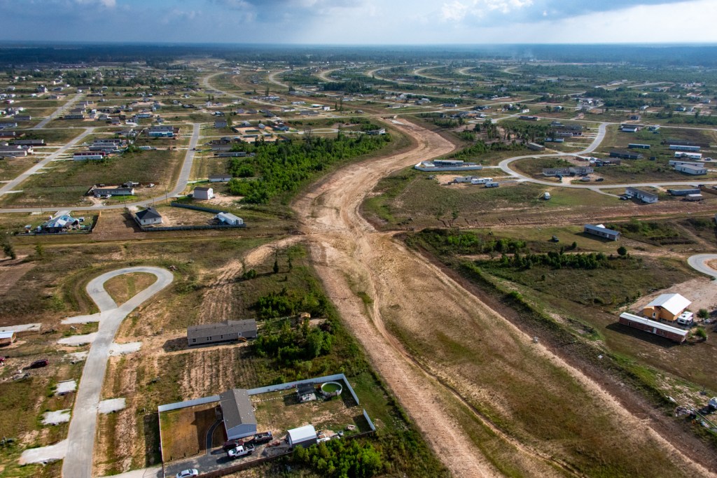
The Largest Development Few Know About
Colony Ridge is large and growing rapidly. The satellite image below shows how it has virtually doubled in size within the last two years as it has grown from left to right and bottom to top. The large area in the lower left began developing around 2011. Those lines that look like hashmarks are thousands of mobile homes.


Colony Ridge already comprises more than 30 square miles. That makes it approximately one third the size of the area inside Houston’s 610 loop.
Erosion a Major Issue
Colony Ridge drains into three watersheds: the East Fork San Jacinto, Luce Bayou and Tarkington Bayou. And all of them drain into Lake Houston. That will make erosion from Colony Ridge Harris and Liberty County’s problem forever.
During floods, erosion will reduce the conveyance of downstream channels and rivers. Page 148 of the Liberty County Subdivision and Development Regulations has this to say about the effects of erosion and sedimentation.
- “Erosion and sedimentation can have very serious effects on storm water drainage.”
- “Erosion can cause slope failures, increase roughness coefficients, and generally reduce the efficiency of drainage channels. However, sediment deposition can clog drainage culverts and reduce the available conveyance in open channels.”
- “Erosion can significantly reduce the maintainability of drainage facilities and increase the cost of maintenance by increasing the frequency with which repairs are required.”
LJA engineering wrote a letter to the Liberty County Engineer that underscores the need to plan ahead as the county transitions from rural to urban. “While limited regulation of development in a rural area may not significantly impact drainage issues, Liberty County is now challenged with explosive population growth and a particularly high percentage of socially vulnerable residents…” said the letter.
Hidden Cost to Downstream Residents
Most people in Harris County don’t even know that Colony Ridge exists. Yet the drainage practices there affect dredging costs downstream. The City of Houston, Harris County and Army Corps spent almost a quarter billion dollars dredging the headwaters of Lake Houston between Harvey and mid-2021.
Clearly, not all of that sediment came from Colony Ridge. However, the development practices in Colony Ridge and other developments like it will set the pattern for the future.
Developments are virtually impossible to change after people start building next to undersized basins and ditches that erode more with every substantial rain.
What You See Makes You Question What You Don’t See
Substandard construction practices make you wonder about engineering practices. Did Colony Ridge engineers produce reliable, accurate estimates of drainage needs? Are those ditches and detention basins sized properly? Will they hold enough runoff to protect residents?
Probably not. Even assuming engineers and contractors did their jobs properly (a big assumption), Liberty County still defines a 100 year/24 hour rainfall as 13.5 inches (see page 108), a rate associated with pre-Atlas 14 days.
Atlas 14 catalogs the current national precipitation frequency standards for every community in the U.S.
However, the phrase “Atlas 14” appears nowhere in the 2019 Liberty County Subdivision and Development Regulations.
But NOAA now defines a 100 year/24 hour rainfall for nearby Cleveland, TX, as 17.1 inches – a 27% increase above the current Liberty County standard. So in a hundred-year rainfall, everything you see in Colony Ridge will be 27% short of capacity. Few people likely understand this.
Consider also that NOAA is already working on replacing Atlas 14 with Atlas 15!
Posted by Bob Rehak on 8/16/23
2178 Days since Hurricane Harvey
The thoughts expressed in this post represent opinions on matters of public concern and safety. They are protected by the First Amendment of the US Constitution and the Anti-SLAPP Statute of the Great State of Texas.


