Harris County Flood Control District (HCFCD) contractor Sprint Sand & Clay has started laying out, clearing and excavating a large, new detention pond that will more than double capacity on Woodridge Village. Woodridge contributed to flooding hundreds of homes along Taylor Gully twice in 2019.
When the developer clearcut approximately 270 acres, the loss of forests and wetlands decreased natural detention capacity on the land. This should help restore it.
Project Outline Becoming Visible
Last week, Sprint started building a construction road into the site. This week it appears that they also dug a shallow trench outlining the perimeter of the pond and started clearing brush within it.
Photograph taken looking NE from SW corner of Woodridge Village. New detention pond will go in foreground. The shallow trench may be the outline of the new basin. Contractor appears to be staying “inside the lines.”Earth-moving equipment worked Saturday and was back at it Monday morning, 1/31/2022.
How the Math Works Out
Sprint will ultimately excavate approximately 500,000 cubic yards of fill which translates to 310 acre feet. When Perry left the site, it had constructed 271 acre feet of detention. The site needed another 108.4 acre feet of detention pond capacity to meet Atlas-14 requirements, but will get 310 (the number of acre feet in 500,000 cubic yards). That almost triples the required additional volume and more than doubles the current capacity…all for $1000.
The $1000 is the out of pocket cost to taxpayers. Under the terms of it’s E&R contract, Sprint will make its profit by selling the dirt it excavates to third parties out of the floodplain. Their contract obligates them to excavate at least 5000 cubic yards per month. There is no monthly max.
In case you have kids or grandkids who like playing with dump trucks, 500,000 cubic yards works out to 50,000 loads. That equals the number of fingers and toes on 2,500 kids. And that’s way more than all the students in Kingwood Park High School!
Turn this into a learning exercise!
About E&R Agreements
E&R agreements provide an opportunity for making progress in advance of future basin construction. These agreements essentially provide a head start in the excavation process before the detention basin is fully designed and constructed.
Residents should beware of heavy equipment entering and leaving the site. The site will remain fenced through the completion of construction.
HCFCD expects to hold public meetings beginning in April to discuss other possible uses, i.e, recreation, restoration, etc., on the site. More news to follow.
Posted by Bob Rehak on 2/2/22, repeating digit day.
1618 Days since Hurricane Harvey
https://i0.wp.com/reduceflooding.com/wp-content/uploads/2022/02/20220131-DJI_0675-2.jpg?fit=1200%2C799&ssl=17991200adminadmin2022-02-02 21:47:482022-02-02 21:47:51Woodridge Village Detention Basin Capacity Doubling
After photos showed clear construction permit violations at the Laurel Springs RV Resort, a City inspector said he found no problems there. Then, 311 closed the case. But Mayor Pro Tem Dave Martin’s office said another group was investigating. Martin’s chief of staff did not elaborate.
RV Park Drains its construction pond into Harris County Precinct 4’s new Edgewater Park in background.
This violated the terms of the developer’s construction permit. The trees behind the trench belong to Harris County Precinct 4 Park System. And the construction permit clearly states that “stormwater runoff shall not cross property line.”
Contractors covering up pipe that will convey future discharges. Photographed yesterday.
So I filed a complaint with the City’s 311 system at the request of Mayor Pro Tem Dave Martin’s District E staff.
Finally, today (Tuesday morning), I tried to photograph the drain/trench again. But contractors had covered it up and repaired the dike. If you hadn’t seen the previous pictures, you would never suspect a drainpipe was there (except for some black silt fencing around the intake which will be taken down).
By Tuesday morning, contractors had repaired the pond wall. Area circled in red is the outfall, covered with water.
Extent of Silty Runoff
The silty stormwater ran almost all the way down to Hamblen Road.
Water should have gone under Laurel Springs Lane and into the detention pond above via COH storm sewer. However, the contractor discharged it into the park instead. Note sediment-laden water in foreground.A large portion of the park appears to be inundated with silty discharge.Looking north toward detention pond on RV site from over Edgewater Park. Note silty water in foreground.
City Inspector Found No Violations
As I reviewed Tuesday’s images, I received an email from 311 saying the inspector found no problems and that 311 had closed the case. Obviously, the 311 operator didn’t clearly communicate the nature of my complaint. It was about stormwater runoff and construction-permit violations, not a fence line encroachment.
And clearly, the inspector didn’t:
Look at the approved drainage plan that showed the outfall should be going into the City storm sewer under Laurel Springs Lane.
Understand that draining water onto neighbor’s property violates the construction permit and state regulations.
Know the trees below the construction site belong to the County Park. He thought they belonged to the contractor. (See below.)
Response from 311 to complaint about construction stormwater violations.No pictures were attached despite text of email.
Inspector Felt Discharging into County Park Was Best Management Practice
To add insult to injury, the inspector characterized discharging into Edgewater Park’s vegetation as a contractor best management practice (BMP). Obviously, he thought the trees belonged to the contractor. He didn’t bother to explore who owned the land below the construction site or how far south the discharge had traveled.
Responses like this give the City a black eye.
I immediately emailed Mayor Pro Tem Dave Martin’s office about the 311 response. Jessica Beemer, his chief of staff, responded that the case wasn’t really closed. She said a different group had been assigned to investigate the complaint. But, as of this writing, she did not elaborate.
The TCEQ hopes to respond to a separate complaint by tomorrow. And I met several Harris County employees investigating the construction this morning in response to other complaints.
Stay tuned. More news to follow. This isn’t over yet.
Posted by Bob Rehak on 2/1/2022
1617 Days since Hurricane Harvey
The thoughts expressed in this post represent opinions on matters of public concern and safety. They are protected by the First Amendment of the US Constitution and the Anti-SLAPP Statute of the Great State of Texas.
https://i0.wp.com/reduceflooding.com/wp-content/uploads/2022/02/20220201-DJI_0728-2-copy.jpg?fit=1200%2C799&ssl=17991200adminadmin2022-02-01 19:44:112022-02-01 20:49:24City Inspector Finds No Problems At RV Park. 311 Says “Case Closed.” Martin’s Office Says “Not So Fast.”
Contractors drain the RV Park detention pond Saturday afternoon, 1/29/22, into Edgewater Park at top of frame.
The pipe leads from the inside to the outside of the pond near Harris County Precinct 4’s new Edgewater Park. This is not an overflow measure. The intake is at the bottom of the pond.
The RV owners are burying a permanent conduit to drain silty stormwater into the park’s wetlands and cypress ponds.
See below.
Same trench on Monday morning, 1/31/22. Pond is in lower left; park in upper right.Contractors are filling the trench to bury the pipe.
Furthermore, the City explicitly prohibits letting runoff cross another’s property.
Detail from approved drainage plan.See first sentence under “Approved Storm Drainage.” “Stormwater runoff shall not cross property line.”It now is.
Does the second sentence about exceeding capacity of the City of Houston storm sewer system have the developer worried? Could that be the reason for the pipe?
I became suspicious on Saturday when I saw black pipe piled near where plans called for reinforced concrete pipe (see below). That pipe looks suspiciously like the pipe now being covered up by the contractor, although in fairness, I did not see them move the pipe.
Image from Saturday afternoon, Jan. 29, 2022. Note black pipe near adjacent work area.But on Monday morning, there was no sign of black pipe or any kind of pipe entering the pond from this cornerwhere plans said it should be.
Controversy Continues to Swirl Around Pond
From the start, controversy has swirled about the size of the detention pond. The RV park received its construction permits one day before new regulations went into effect. The new regs would have required virtually doubling the size of the pond.
How they operate with such impunity bewilders me. We definitely need the county attorney to investigate.
Posted by Bob Rehak on 1/31/2022
1616 Days since Hurricane Harvey
The thoughts expressed in this post represent opinions on matters of public concern and safety. They are protected by the First Amendment of the US Constitution and the Anti-SLAPP Statute of the Great State of Texas.
https://i0.wp.com/reduceflooding.com/wp-content/uploads/2022/01/20220131-DJI_0669-3.jpg?fit=1200%2C799&ssl=17991200adminadmin2022-01-31 17:49:232022-01-31 18:06:28RV Contractor Laying Pipe To Run Stormwater Through Detention Pond Wall Into Park
Only about 4.4% of the land in the U.S. has estimated impervious cover greater than 40%. Usually, high percentages of impervious cover are associated with shopping malls; large apartment complexes; manufacturing and warehouse districts; and densely populated urban neighborhoods. Now there’s a new entry in that category: the Preserve at Woodridge – single-family housing so close together that you can spread your arms and touch two homes.
If you like living close to neighbors, the Preserve at Woodridge will be for you. Guefen, the developer, claims 65% impervious cover. Assuming their calculations and claims are accurate, what does that look like?
We can now see. Builders have framed the first cluster of homes. I’ve posted before about how close together these homes would be. But until you see them, the proximity is hard to fathom. They certainly don’t pass the eyeball test for 65% impervious cover.
Pictures Dramatize Proximity of Homes
The good news is that these homes, some as large as 660 square feet, definitely have more space than a porta-potty or a cargo container. You’ll be able to vacuum the home in world-record time. And you’ll never have to wonder where you left your cell phone. It would be impossible to lose in a home this small.
The cluster of homes shown above is also shown in the schematic below.
Note 4.95-foot width between home in middle and one below it. See actual space below where ladder is.
You know things are tight when the developer measures the distance between homes down to the hundredth of a foot (1/12th of an inch).
Notice how the ladder leaning on one home is braced against the foundation of another.Those two homes have less than five feet of separation.
Regardless, the engineers claim the development has 65% impervious cover for the purposes of calculating detention pond volume. That means 35% would be pervious, i.e., grass. See below.
From developer’s drainage calculations, page 20.
But Where Do You Put the Lawnmower?
But with so much shade between the homes, can you really get grass to grow? And if you can, where do you put the lawnmower? The developer has only 34 garage spaces for 131 homes. Perhaps you can put the mower under your Murphy bed. Or in your gym bag.
More pads for the next batch of homes.Status of Preserve-at-Woodridge construction as of 1/29/2022.
Guefen plans to rent, not sell these homes. I guess you could consider these a step up from apartment living. But the developer has not preserved much at the Preserve. They certainly won’t live up to the reputation of the Livable Forest.
This is going to feel more like high-density, inner-city living … without the public transportation. We’ll soon see if there really is a market for this concept in the Kingwood Area.
How Impervious Cover Can Contribute to Flooding
The higher the percentage of impervious cover, the less stormwater soaks into the ground. It runs off faster. And without sufficient detention pond capacity, flood peaks build higher.
Posted by Bob Rehak on 1/30/2022
1615 Days since Hurricane Harvey
The thoughts expressed in this post represent opinions on matters of public concern and safety. They are protected by the First Amendment of the US Constitution and the Anti-SLAPP Statute of the Great State of Texas.
Stormwater Drainage Plan approved by City of Houston just three months ago. City stamped the red note in the middle of the detention pond below.
A reader emailed me this morning to alert me to the fact that the contractor was digging through the wall of the detention pond to drain it. Pumping the water over the edge evidently didn’t work fast enough.
Note trench being dug through wall of detention pond to empty stormwater runoff onto neighboring property – Harris County Precinct 4’s Edgewater Parkon left.On Saturday afternoon, 1/29/22, contractors were enlarging the breach to drain runoff faster.
The excavator seemed to be widening and deepening the ditch down to level of the pond bottom.
Was the timing of the excavation of this breach on a Saturday afternoon intentional to avoid City Inspectors? Will they fill this trench back in before Monday morning?
It’s not clear whether the contractor received permission from the City or County to dig the trench that emptied the pond. Phone calls and emails went unanswered Saturday.
There’s not much more to say about this. In fairness, construction is always difficult and risky. Wet conditions can create expensive delays that put tremendous pressure on all involved. And, of course, partially completed projects never fully function as intended.
Ironically, a close reading of drainage plans reveals that the contractor is supposed to be pumping the water into the COH storm sewer system. The plans also estimate that the draining the entire pond would take just 13 hours with two pumps. However, the connection to COH’s storm sewer has not yet been installed.
Note the construction activity in the top right corner of the last photo below. The contractor appears to be building up a wall around the planned pump cutoff station.
Where stormwater will be pumped into Lakewood Cove’s stormwater sewer system. See plans below.
From Laurel Springs RV Resort approved drainage plan. Plan shows contractor will pump contents of pond into Lakewood Cove storm drain system via a 24 inch pipe running under Lakewood Cove. From there, water will drain, downhill into Lakewood Cove’s detention pond near HamblenRoad.
Pray all that pumping doesn’t back stormwater runoff up into the streets of Lakewood Cove.
Posted by Bob Rehak on 1/29/2022
1614 Days after Hurricane Harvey
The thoughts expressed in this post represent opinions on matters of public concern and safety. They are protected by the First Amendment of the US Constitution and the Anti-SLAPP Statute of the Great State of Texas.
https://i0.wp.com/reduceflooding.com/wp-content/uploads/2022/01/20220129-DJI_0612.jpg?fit=1200%2C799&ssl=17991200adminadmin2022-01-29 19:28:002022-01-30 20:36:09“Stormwater Runoff Shall Not Cross Property Line”
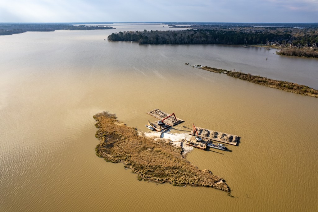
Mechanical dredging is sloooooooooow. Two months after my last dredging update, contractors are still working on the same portion of the East Fork Mouth Bar complex just north of the entrance to Luce Bayou. The sand bar is question is one of many in the area that popped up after Harvey and Imelda.
Pictures Taken on 1/28/22
I took the first three images below this morning.
Looking East across the San Jacinto East Fork from Kingwood toward Luce Bayou in upper right. North is to the left.Photo taken on 1/28/22.Dredgers are now working on a small island just upstream from Luce. But there’s a lot of work yet to do.Photo taken on 1/28/22.
The San Jacinto East Fork Mouth Bar grew more than 4,000 feet in length during Harvey and Imelda. River depth was reduced to 3 feet, according to boaters. That reduced conveyance of the river and contributed to flooding of homes on both sides.
It took three months just for contractors to dredge their way through the Royal Shores channel to get to East Fork (July, August, September 2021). East Fork dredging started in October last year. Removing sediment from the area in red above has taken four months. But it’s only a small portion of the work that needs to be done as you can see in the second image above that looks upstream.
Naturally, residents are asking, “How much more does the City intend to do?” The answer to that question is still unsettled.
Vendor for Long-Range Dredging Plan Still Not Decided
The project attracted a lot of attention. Thirteen companies expressed interest. And eleven signed up for a pre-bid conference. However, the purchasing agent for the City, Bridget Cormier, stated that “The City has not yet made a decision, nor a recommendation for award yet.” She explained, “We are still in the evaluation phase and have requested additional information from suppliers that moved forward in the process.”
Posted by Bob Rehak on 1/28/2022
1613 Days since Hurricane Harvey
https://i0.wp.com/reduceflooding.com/wp-content/uploads/2022/01/20220128-DJI_0561.jpg?fit=1200%2C799&ssl=17991200adminadmin2022-01-28 13:34:082022-01-28 14:28:52Dredgers Still Nibbling Away at East Fork Mouth Bar
In the afternoon of 1/27/22, Harris County Flood Control District (HCFCD) contractor Sprint Sand & Clay began excavation of additional detention pond capacity on Woodridge Village. Woodridge is the former Perry Homes property implicated in the flooding of Elm Grove Village and North Kingwood Forest twice in 2019. Numerous factors contributed to the flooding. But insufficient detention pond capacity led the pack. The volume excavated by Perry contractors fell about 40% short of Atlas-14 requirements.
Initial Work Will Improve Access
The initial work will improve access to the site. Sprint says it hopes to begin excavation in earnest next week. By comparing the picture and map below, you can see that the task will be immense.
Looking NE at main portion of Woodridge Village Site as excavation of new detention pond begins. It will extend to the pond in the upper right.Excavation off the green area above will more than double the detention pond capacity on the Woodridge Village Site.
History of Project and Contract Details
In February last year, HCFCD purchased Woodridge Village with the intention of creating additional detention pond capacity. Fast forward to November 2021. HCFCD and Sprint signed an E&R contract. E&R stands for Excavation and Removal. Under the terms of their contract, Sprint Sand & Clay will excavate material as needed.
Taxpayers generally like E&R contracts, but anxious homeowners may worry about the “as needed” clause. That can slow work down if market demand falters. Nevertheless, Sprint has an obligation to remove at least 5,000 cubic yards a month. That’s enough to fill 500 dump trucks. In total, they’ll fill 50,000 before the job is done.
Covid Delayed Start
The project could have started in December, but Covid-related absences slowed the contractor. This afternoon, however, the contractor began a) clearing an access road for trucks into the site and b) clearing space for a construction trailer near the excavation. The contractor hopes to begin excavation in earnest next week. But again, they make no guarantees on that point.
Pictures Taken 1/27/22
Regardless, signs of progress are welcome. Here are pictures taken of the project just hours into it.
Sprint began by clearing a two-lane road for their trucks opposite the entrance to the Northpark Recreation Area on Woodland Hills Drive. The company plans to work around the high school’s schedule (upper right).The company began by clearing an area near the entrance to the largest portion of the site.Dirt from the initial excavation is being stockpiled near the Woodland Hills entrance opposite Kingwood Park High School for the moment.
The contractor appears to be shuttling dirt from the excavation area toward the entrance. It’s not immediately clear whether that dirt will be used to build up a construction road or hauled offsite.
Posted by Bob Rehak on 1/27/2022
1612 Days since Hurricane Harvey
https://i0.wp.com/reduceflooding.com/wp-content/uploads/2022/01/20220127-DJI_0534.jpg?fit=1200%2C799&ssl=17991200adminadmin2022-01-27 17:24:592022-01-27 17:26:50More Woodridge Village Excavation Started Today
US Fish & Wildlife Map Shows Wetlands Dot Development
From US Fish & Wildlife Service National Wetlands Inventory. Madera will stretch past the left/right edges of this picture north of SH242 (the east/west highway near bottom.) FM1314 bisects picture from N to S in middle.
FEMA’s Base Flood Elevation Viewer Shows Flood Risk
Note that this survey shows only about a quarter of Madera (see below). The survey stops abruptly on the western margin. So, it is hard to say with certainty how bad flooding is throughout the rest of the site.
Yellow outline shows approximate outline of FEMA BFE survey shown above within Madera tract(black/white outline).
Option to See Depth of 100-Year Flood Waters
Also note that the purple area shows only the extent of 100- and 10-year floods. However, within the FEMA BFE viewer, you also have the option to select a layer that illustrates the depth of 100-year floodwaters. See below. (FEMA does not offer the option to show the depth of 10-year floods.)
FEMA’s estimated Base Flood Elevation Viewer showing extent of 100-year flood on left and depth on right.
Limitations of BFE Viewer
Of course, FEMA shows “estimated conditions” before developers bring in fill and alter drainage. But notice how a pre-existing development near Madera would fare in the same 100-year flood. You can see the close up below just above SH242 near the right edge of the image above.
FEMA shows that most homes in this development are still in the flood zone and would still flood to a depth of 1-2 feet in a hundred-year flood.
The street leading out of the development to SH242 could be under more than FIVE FEET of water in places!
FEMA Base flood Elevation Viewer
FEMA’s “Estimated Base Flood Elevation” is “The estimated elevation of flood water during the 1% annual chance storm event.” Structures below the estimated water surface elevation may experience flooding.” A 1%-annual-chance flood is also known as a 100-year flood. FEMA defines properties with a 1% annual chance of flooding as having “high flood risk” and says they have a 26% chance of flooding during the life of a 30-year mortgage.
Purposes of BFE Viewer
The agency developed its Base Flood Elevation viewer with several purposes in mind. To:
Inform personal risk decisions related to the purchase of flood insurance and coverage levels.
Inform local and individual building and construction approaches.
Prepare local risk assessments, Hazard Mitigation Plans, Land Use Plans, etc.
Provide information for “Letter of Map Amendment” (LOMA) submittals.
A LOMA lets the developer of a subdivision change the depiction of how flooding affects his/her subdivision. It’s the key to offering up-to-date risk assessments.
Full BFE Reports Available
FEMA also lets you download or print full BFE reports that give more specific estimates of flood depth at exact points, not just within a wide area.
FEMA’s BFE Viewer also gives you the option to print out a detailed flood-risk report by clicking on a point.
At the point shown above, you could expect 4.2 feet of water above the land surface in a 1%-chance flood. For the full report, click here.
Here’s what that point looked like last Saturday (1/22/22) from the air.
Madera development today at FM1314 and SH242, the point shown in BFE report above.
Cross-check this area on the maps above for wetlands and swamps! Then you can see why it’s so soupy.
BFE, Fill Not Mentioned in Drainage Analysis or Construction Plans
Text searches of Madera’s construction and drainage plans showed no references to “BFE” or “base flood.”
It seems unlikely that a “cut and fill” operation could excavate enough dirt from Madera’s drainage channel (dotted blue line with red parallel lines) and detention ponds to raise the whole site out the hundred-year flood zone. Five feet is a lot of fill for a 1700 acre site.
To raise a site this large, contractors would likely have to bring in fill from outside the property. But a text search from the word “fill” did not turn up any exact matches either.
So maybe they’re just planning to create the world’s biggest drain and hope to carry water off before it can reach homes.
However, a summary of the Madera master drainage plan notes…
“Coordination with MCED [Montgomery County Engineering Department] andadjacent property owners is recommended … on the potential need for inundation easements.”
The thoughts expressed in this post represent opinions on matters of public concern and safety. They are protected by the First Amendment of the US Constitution and the Anti-SLAPP Statute of the Great State of Texas.
https://i0.wp.com/reduceflooding.com/wp-content/uploads/2022/01/20220125-Screen-Shot-2022-01-25-at-3.52.07-PM.jpg?fit=1200%2C600&ssl=16001200adminadmin2022-01-27 06:08:242022-01-27 06:22:32New MoCo Development Being Built on Wetlands in 10-Year Flood Zone
Yesterday, 1/25/22, Harris County Commissioners Court named Dr. Christina Petersen as the new head of the Flood Control District. That position had been open for seven months since Russ Poppe resigned last July. Below is a brief bio of Petersen distributed by David Berry, the new Harris County administrator.
Dr. Christina Petersen, new head of Harris County Flood Control District
Petersen Background
“Dr. Christina “Tina” Petersen will serve as the first female Director of the Flood Control District in its 85-year history. She joins Harris County from the Harris-Galveston Subsidence District, where she has served as Deputy General Manager for the past 3 years and oversaw the District’s Regulatory Planning, Scientific Research, and Water Conservation Programs. She earned her Bachelor’s degree in Biology and Environmental Studies from Baylor University and her Master’s and doctoral degrees in Environmental Engineering from the University of Houston. She is a registered Professional Engineer in Texas and has over 15 years of experience working with local city governments as well as water authorities, State agencies, and cities across Texas to deliver complex water supply and water quality projects.”
I’m trying to learn more about Dr. Petersen’s background. What I didn’t see in this was any mention of hydrology experience. Nor did I see any mention of private-sector experience. More news to follow.
Other Related Appointments
Meanwhile, Berry’s press release also listed:
Dr. Milton Rahman, who will serve as the new County Engineer. Dr. Rahman is a Professional Engineer, Project Management Professional, and Certified Floodplain Manager.
Lisa Lin, the first director of the Sustainability for Harris County.
Daniel Ramos, the new Executive Director of the Office of Management and Budget.
Posted by Bob Rehak based on a press release by Dave Berry, Harris County Administrator
1611 Days since Hurricane Harvey
https://i0.wp.com/reduceflooding.com/wp-content/uploads/2022/01/Tina-Petersen.jpg?fit=468%2C624&ssl=1624468adminadmin2022-01-26 12:01:582022-01-26 13:27:08Harris County Names Dr. Tina Petersen New Head of Flood Control District
When it comes to flood control in Harris County, you often hear claims of “historic disinvestment” in low-to-moderate income (LMI) neighborhoods. Residents allege that they flood because Harris County Flood Control District (HCFCD) funneled dollars into affluent neighborhoods for decades while ignoring lower-income watersheds. But are those claims true? Not if you look at the numbers since 2000.
What Data Shows
See the table below. I compiled it from data supplied by HCFCD in response to a Freedom of Information Act (FOIA) Request. The table ranks each watershed in the county by its percentage of LMI residents. It also breaks them into two groups – those with percentages of LMI residents above and below 50%.
HCFCD Spending by Watershed since 2000through the end of Q3, 2021.
Harris County has 23 watersheds.
Column 1 shows the watersheds broken into two groups – those with more or less than 50% LMI residents.
Column 2 shows the percentage of LMI residents in the watershed. Those with the highest percentages of low-income residents are the least affluent.
Column 3 shows the historic investment in flood mitigation between 2000 and the end of the third-quarter 2021.
Column 4 shows the historic investment plus inflation compounded annually.
Column 5 shows the percentage of inflation over time.
No Historic Disinvestment
In raw dollars, the eight least affluent watersheds received 61% of all dollars since 2000. Fifteen more affluent watersheds received only 39%.
The 8 less-affluent watersheds received $700 million more than the other 15!
After accounting for inflation, the eight low-to-moderate income watersheds received on average almost $300 million each. The rest received only about $90 million each.
Notice also how the rates of inflation tend to be much higher in the less affluent group. That’s because HCFCD has been spending more money in these watersheds over a longer period of time. For example: If a watershed received a $10 million project in 2000, more inflation would apply than if the investment was made yesterday.
Conclusion: I see no pattern of historic disinvestment in low-to-moderate income neighborhoods by HCFCD.
Funding Flows to Damage
The reality of flood bond spending is far more nuanced than most people have the time or desire to explore. At a high level, though, funding flows to damage.
Older neighborhoods inside the Beltway have higher flood risk because of older development regulations, older building codes, and storm sewers or ditches that have filled in with silt or vegetation. See pictures below from Halls Bayou.
Blocked street drains that turn neighborhoods into detention ponds.
The people in this neighborhood (Halls Bayou) claim they “flood every time.” But if you look at historical gage data, you will see that Halls came out of its banks at Tidwell only twice in the last 20 years – once during Harvey and once during Imelda. Harvey was bad. During Imelda, the bayou overtopped banks only by a foot.
I conclude that repeat flooding in the neighborhood shown above comes from blocked street ditches. They turn neighborhoods into giant detention ponds. But the ditches are the responsibility of Precinct Commissioners, not HCFCD.
To sum up, I do not see a pattern of historic disinvestment by HCFCD in Harris County’s LMI neighborhoods.
Posted by Bob Rehak on 1/25/2022
1610 Days since Hurricane Harvey
https://i0.wp.com/reduceflooding.com/wp-content/uploads/2022/01/Screen-Shot-2022-01-25-at-7.07.51-AM.png?fit=758%2C1060&ssl=11060758adminadmin2022-01-25 11:27:132022-01-25 11:37:35Myth Buster: Historic Disinvestment in LMI Watersheds?