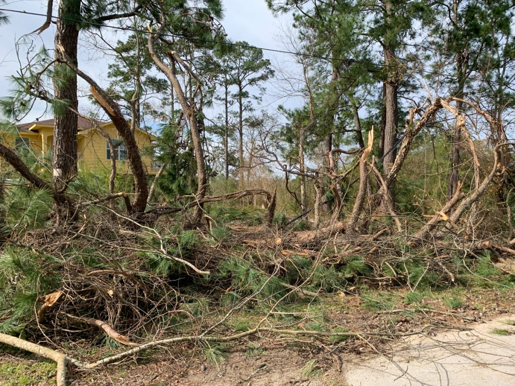
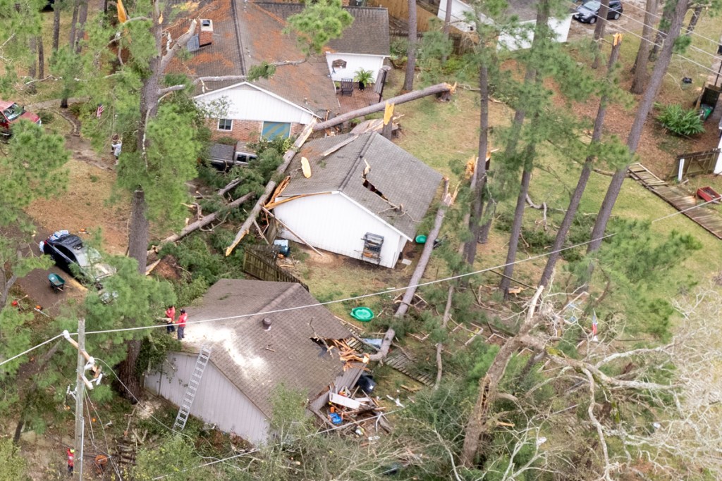
Imagine you’re getting on an airplane and you see someone popping rivets out of the wing. You ask the pilot, “What’s that guy doing!?”
The pilot says, “Oh, he’s popping rivets. Our accountants have found that can eliminate weight and improve fuel economy.”
“But won’t that increase risk?” you ask.
The pilot replies, “Somewhat, but our engineers believe it won’t bring the plane down.”
Would you get on that airplane? Would you live in this proposed development? Or downstream from it? See details below.
Details of Northpark South
Here are the plans presented to the Planning Commission last Thursday for a plat of Northpark South. The commission deferred action on them until the next meeting. The developer is Hannover Estates, LTD. RG Miller engineered the development.
Pretty location!Just don’t let your kids go fishing there.
Of course, the homes will be built on the highest ground. But look how far the floodplain (dotted line) cuts into them.
Northpark South floodplains. Of course, these are based on 1980s data. Don’t be fooled by the data on the map. That’s the date of the background image. In Harris County, the new flood maps will reportedly expand the floodplains by 50% as a rule of thumb. But this is MoCoand the last update was much longer ago.
Here’s how that area looked during Harvey.
US Fish & Wildlife Service Map of wetlands (and former wetlands) on the site (center of frame).
Looking W from over end of Northpark Drive. Sorters-McClellan cuts through bottom of frame from left to right. West Fork cuts through sand mines in the background.
The barren spot just right of center is the wetland area that will be filled in to make home sites.
Meet the neighbors.
Where the subdivision drainage will go…straight into the West Fork.
Water flowed so quickly through this area during Harvey that it moved and sunk this excavator within the mine.
Another Development Targeted at the Uninitiated?
The shame of it is that if Northpark South gets built, the developer will likely build starter homes and market them to couples with young children. They’re the least knowledgeable about flood risk.
Posted by Bob Rehak on 10/31/2021with thanks to Paul Ehrlich for the parable and Mai Truong for the heads up on this
1524 Days since Hurricane Harvey
The thoughts expressed in this post represent opinions on matters of public concern and safety. They are protected by the First Amendment of the US Constitution and the Anti-SLAPP Statute of the Great State of Texas.
https://i0.wp.com/reduceflooding.com/wp-content/uploads/2021/10/20211031-DJI_0631.jpg?fit=1200%2C800&ssl=18001200adminadmin2021-10-31 19:31:372021-11-01 17:50:50More West Fork Wetlands near Northpark Drive Could Soon Be Developed
Last week, I started getting barraged by emails from stunned Lakewood Cove residents waking up to the sound of bulldozers and chainsaws. Someone was cutting down 22 acres of trees between them and the Union Pacific Railroad tracks that parallel Loop 494 – for an RV park – without any public notice.
I went to the site on Monday and started investigating. On Wednesday, I posted what I had learned. Then I kept researching. Half a day on Thursday. All day Friday. And all day Saturday. It’s like digging into a House of Mirrors. But it’s no funhouse. There are so many legal entities with so many similar names that it’s easy to confuse them. That may be the intention.
For instance, you might think that Higbie Ventures LP is the same as Higbie Ventures GP LLC or Higbie Ventures of Texas, Inc. Likewise, you might think Laurel Springs RV is the same as LS RV Resort. But it’s not an abbreviation. They play different roles. But what are they?
So Many Questions, So Little Time
The deeper I dig into the shadowy web of contractors, managers, and investors behind this venture, the more questions I had.
According to residents who have tried to contact them, they refuse to answer questions or meet with the affected community. Why?
The City of Houston Planning Commission, Public Works Department and District E office have not returned phone calls or emails. Why?
The Harris County Appraisal District website contains incomplete and dated records about the land. Why?
The Harris County Flood Control District said they were not given an opportunity to review the plans even though part of the property is in the flood plain of the San Jacinto West Fork.
The City permits for the work show a different legal entity than the TCEQ stormwater permit. Why?
According to the Secretary of State’s website, the two organizations supposedly responsible for the clearing haven’t filed franchise-tax public-information reports in more than two years – but are somehow still doing business in the State of Texas. Why?
Could that affect the validity of the building permits?
The contractor responsible for the clearing (according to the TCEQ permit) has NO website, and has apparently subcontracted the work to another company. Why?
The man behind the primary contractor has started at least 11 companies or partnerships in Texas. None have websites. Most operate out of a PO Box. Most use the same phone number. He’s lost four of the entities to tax forfeitures and dissolved two others. What’s going on there?
And the people who own the property operate a maze of more than 100 other partnerships and corporations. Will they keep and manage the property or sell it to investors?
How will:
The property be managed and marketed? Who will it cater to?
The RV park affect drainage in Lakewood Cove next door?
Heavy vehicles affect the streets?
The absence of trees affect train noise?
Trees Mostly Gone
Just before sundown tonight, I went back to see how many trees remained. And the answer was, “not many.” They seem to have cleared virtually the entire site with the exception of the southern end where the detention pond will go. There’s also a strip of trees about two trees wide next to the utility corridor that parallels the railroad tracks. Next to Laurel Springs, that narrows to one tree in some places and zero in others.
At this point, the battle to save the trees is over. They will all disappear faster than you can say “injunction.”
The developer has executed a perfect blitzkrieg attack that would make Hitler jealous.
Below are pictures taken on Saturday, 10/30/2021.
Looking SSE. Lakewood Cove on left. UP tracks run from bottom to top on right.
Detention pond will go approximately where red box is.
At this rate, clearing could be completed in a week or two.
Location of Project
For those of you who don’t know where Lakewood Cove is, see below. It’s the area immediately to the right of the red. Friendswood Development Company never owned this land, so it’s not technically a part of “Kingwood,” which is a Friendswood trademark. Therefore, it doesn’t legally enjoy the protection of Kingwood’s deed restrictions. However, in every other sense, it is very much a part of the Kingwood community.
Location of land being cleared for new RV Park is in red. Land between the red and the river will become Harris County Precinct 4’s new Edgewater Park.
Posted by Bob Rehak on 10/30/2021and revised on 10/31/2021 to include the “Location of Project” information immediately above.
1523 Days Since Hurricane Harvey
The thoughts expressed in this post represent opinions on matters of public concern and safety. They are protected by the First Amendment of the US Constitution and the Anti-SLAPP Statute of the Great State of Texas.
https://i0.wp.com/reduceflooding.com/wp-content/uploads/2021/10/20211030-DJI_0615.jpg?fit=1200%2C799&ssl=17991200adminadmin2021-10-30 21:03:472021-11-11 17:33:03In One Week, More Questions than Trees Remain at Site of First Kingwood RV Park
In a straight party-line vote, Harris County Judge Lina Hidalgo, Precinct 1 Commissioner Rodney Ellis and and Precinct 2 Commissioner Adrian Garcia approved a modified version of a plan presented weeks ago by Ellis. It contained an even bigger surprise than in Ellis’ original plan. And it takes gerrymandering to a whole new personal level that really strikes home.
The Old Switcheroo
The plan approved on 10/28/2021 creates two safe, predominantly Democratic precincts for Ellis and Garcia while forcing Republicans Cagle and Ramsey to run in each other’s precincts where they are relatively unknown. That will mean Republicans will have to raise and spend more money to compensate for low awareness.
County law specifies that precinct commissioners must livein the precincts they represent. Currently Ramsey lives in and represents Precinct 3; Cagle lives in and represents Precinct 4. So Ellis carefully gerrymandered the boundaries of the new Precinct 3 to include Cagle’s home and the new Precinct 4 to include Ramsey’s.
That means both Republicans would have to move their homes in order to represent their current districts.
Hidalgo Calls It Payback for Not Raising Taxes
Judge Lina Hidalgo supported the last minute entry in the redistricting sweepstakes. When Cagle questioned why, she said it was payback for Republican’s walking out and blocking a tax increase earlier this year. A tax increase must be approved by a 4-1 supermajority. So when Cagle and Ramsey walked out of the meeting, Democrats did not have the votes they needed.
The map below will now define the new precinct boundaries. The other major change: Garcia’s Precinct 2 loses the heavily Republican far northeast portion of the county. That will shore up his re-election chances. Last time, he won by just 2,000 votes and his seat was widely regarded as the most vulnerable in this election, given the old precinct boundaries.
The redistricting map adopted today by Harris County. Lines represent old boundaries. Colors represent new boundaries. Ellis switched the numbers 3 and 4.
Cities and counties without healthy checks and balances can devolve into blatant political corruption. The next election could determine the tenor of politics in Harris County for decades to come.
The next Harris County election will be the primary in May.
Posted by Bob Rehak on 10/28/2021
1521 Days after Hurricane Harvey
The thoughts expressed in this post represent opinions on matters of public concern and safety. They are protected by the First Amendment of the US Constitution and the Anti-SLAPP Statute of the Great State of Texas.
https://i0.wp.com/reduceflooding.com/wp-content/uploads/2021/10/Ellis-3-Final_Page_1-copy.jpg?fit=1200%2C927&ssl=19271200adminadmin2021-10-28 19:21:322021-10-29 07:47:28Democrats Approve Modified Ellis Redistricting Plan Along Party Lines
Higbie Ventures LP, a construction company headquartered at 3733 Westheimer, has started clearing more than 20 acres immediately north of Harris County Precinct 4’s new Edgewater Park at US59 and the San Jacinto West Fork for a recreational vehicle park that would hold 182 RVs. The land sits between the Union Pacific Railroad Tracks and Lakewood Cove just west of Laurel Springs Drive.
Looking S from over Union Pacific tracks on right. Lakewood Cove on left. Edgewater Park is the big treed area to the left of the railroad tracks in the distance.Photo taken 10/26/2021.
Goodbye Towering Pines, Hello Oleander
Landscaping plans indicate that the company will clear all the trees that buffer neighbors to the east from the noise of freight trains. Oleander would replace the towering pines. Oleander is pretty but poisonous. It’s toxic to humans and pets if even small amounts are ingested.
Neighbors’ Fears
Neighbors worry about how a nearby RV park could impact their home values, safety and quiet neighborhood traffic patterns. They generate a lot of heavy vehicle traffic that streets weren’t designed for. And the RV owners sometimes also decide to become permanent residents.
This could disrupt replenishment cycles of the cypress ponds in Edgewater Park which will be one of the signature attractions of the park.
Moreover, even though part of the property sits in the floodplain, Harris County Flood Control says it was not given an opportunity to review the plans. And the floodplains shown on the plans correspond to a pre-Atlas 14 era with rainfall amounts roughly 28% lower than today’s.
It’s unclear how Higbie got permits without a public notice. But at a meeting of 150 Lakewood Cove residents last week, not one could remember receiving a notice about the RV Park development.
However, the City of Houston Permitting site shows eight permits issued to the developer for the RV Park.
The plan documents posted on the contractor’s website claim that ALL have received permits from the City of Houston, though they do not show permit stamps, only that they have been reviewed for compliance.
The permits above apply to site work only, not the construction of buildings on the site. These permits relate to site clearing, paving, sidewalks and utilities. However, there don’t appear to be any permits related to actual buildings shown on their plans.
Even though one of the permits shown in a database search is labeled “Building Pmt,” the actual permit says it is for “Structures Other than Buildings.” See below.
The “building permit” associated with the Higbie site says its for structures other than buildings.
Planned Buildings Not Yet Shown on COH Permit Site
The City of Houston District E office has not responded to enquires about whether the site is fully permitted or why the plans do not show permit stamps by city engineers.
Drone Photos Show Extent of Clearing To Date
Drone photos show the contractor has already cleared a large area on the northern portion of the site and is working south. These show the extent of clearing as of 10/26/2021.
Looking NW at site. Lakewood Cove in lower right. RV Park in Center. Lowes in upper right. US59 cuts across top of frame.Looking S again. Site clearing is moving south. The southern edge of the RV Park will roughly parallel the southern extent of homes in this photo. Looking N. The northern end of the site also roughly parallels the northern end of Lakewood Cove. So all homes in the subdivision would be affected.Contractor is leaving trees around the perimeter for now, but the landscaping plan calls for them to eventually be replaced by oleander.
Park Plan Update
Dennis Johnston, Harris County Precinct 4 Parks Director was kind enough to supply these most recent plans for Edgewater Park. The RV park would be above the black line at the top of the frame below. This first image shows trails within and around the park as well as an alternate route to connect Hamblen Road with the bridge over US59 leading to the Sorters-McClellan bridge. The alternate route would provide a way for traffic to avoid blind turns onto 494.
More than 160 Lakewood Cove residents have already signed a petition protesting the RV park. But it’s not clear whether anything can be done at this point to affect the developer’s plan. Neither the developer, Laurel Springs RV, LLC nor contractor have responded to pleas for meetings with residents according to one community leader that I have talked to.
This development raises many questions. I sincerely hope the developer choses to engage with the community to answer neighbor’s questions.
Posted by Bob Rehak on 10/28/2021and updated 10/29/2021 to reflect a difference between the contractor and developer.
1520 Days since Hurricane Harvey
The thoughts expressed in this post represent opinions on matters of public concern and safety. They are protected by the First Amendment of the US Constitution and the Anti-SLAPP Statute of the Great State of Texas.
https://i0.wp.com/reduceflooding.com/wp-content/uploads/2021/10/20211025-DJI_0596-1.jpg?fit=1200%2C799&ssl=17991200adminadmin2021-10-27 20:37:052021-10-28 13:48:36RV Park Developer Clearing Land Near Site of Precinct 4’s New Edgewater Park
During a spirited, but cordial debate Thursday that lasted almost two hours, Harris County Commissioners Court decided NOT to divert $191 million designated for Cedar Bayou in the flood bond. The deciding factor: previous promises not to cancel projects made by Lina Hidalgo and, you guessed it, Adrian Garcia himself.
Commissioners also recognized a need to ask voters for more flood-mitigation money and feared that cancelling projects would jeopardize the trust of voters and put future bonds at risk.
In the end, Commissioners Cagle and Ramsey got Judge Lina Hidalgo to agree with them, and Garcia withdrew his motions to transfer the money. It was reportedly the first time in years that Democrats broke ranks. Garcia seems crushed.
Two Sides Lay Out Opening Positions
Democrats primarily argued that we need to spend the money quickly to protect populated neighborhoods that have repeat flooding instead of newly developing areas.
Garcia led off the debate by stating the ideas behind the motion: flood bond matching funds have not yet fully materialized, so money is short. And cure is more important than prevention.
Republicans argued that voters approved a bond with a list of projects, and that diverting money would violate the public trust and jeopardize future bonds.
Cagle Reminds Hidalgo and Garcia of Previous Promises
The last page of the letter also contained a FAQ sheet. The very first question: “Is Harris County going to cancel my project?” Answer” “No, every project on the Flood Bond project list will be completed.”
Cagle also showed a rambling statement Garcia himself made at Commissioners Court on 8/27/2019. “If anybody and if anybody is watching on live streaming that believes that this body has somehow taken action to eliminate projects that were already planned, already posted, and already listed, I want people to know that whoever is spreading that rumor, whoever may be making phone calls, whoever may be having someone make phone calls, whoever may be out there telling people to call you and tell you come down to Commissioners Court and tell them don’t eliminate our projects or why are you eliminating our projects. I want to make sure you know that that is blatantly false if not maybe a lie. If anyone is getting that kind of information that things of that nature are happening, I’m not sure how this information is getting out there but it is just downright false.”
Whew. That first sentence is 88 words long! But the gist of it is that, “The allegation that we’re eliminating projects is blatantly false.”
Commissioner Ramsey focused mostly on a project he wanted to kill just six months ago, so he could use the money on one he considered more important in the same watershed. However, he was told that he couldn’t. Ramsey, in essence, was arguing that a double standard seemed to exist.
Those reminders seemed to turn Hidalgo. Realizing there was no hope of a win, Garcia withdrew the motions (#136 and #323) to divert the Cedar Bayou money.
Garcia Makes New Motion
But that didn’t end the discussion. Garcia made another motion. He asked the county administrator to work with Flood Control to come back with a funding recommendation “for projects outside the 100-year flood plain.” The motion carried unanimously without debate.
However, someone should have asked if he was so concerned about repeat flooding why would he focus efforts on 500-year floods instead of floods with higher frequency.
Misrepresentation of Available Funds
Repeated falsehoods marred the discussion. One had to do with the amount of money available. On numerous occasions, Garcia claimed only $2.5 billion was available. However, because of partnership funds already received and transfers from HCTRA, the total committed to flood mitigation to date exceeds $4 billion. As of June 2021, only another $951 million is needed to fully fund all bond projects with seven years left to find the money. And the GLO is waiting in the wings with another $750 million from HUD. That one grant could come close to fully funding all bond projects.
If you look closely in Garcia’s spreadsheet, you will also see that his consultant claims Garcia’s projects will take more homes out of floodplains than Harvey flooded. Hmmmm, 2494 flooded in Harvey vs. 3697 removed from floodplains. Wonder how that works.
Show Me the List!
Finally, after repeatedly talking about specifics and referring to “this project” or “these projects”, the number of homes that could be removed from the 500-year floodplain, and the rankings of projects, Garcia pretended that “a list” was still in development. However, I later obtained a copy. While Garcia may still be fine tuning the list, he had one that he shared with other commissioners but not the public. That list identified 17 projects from which he compiled the 2,494 structures saved.
The 17 projects include Carpenters Bayou, Vince Bayou, Goose Creek, Jackson Bayou, Spring Gully, Armand Bayou, Galveston Bay, Greens Bayou and San Jacinto watersheds.
Projects Fall within Boundaries of Precinct 2 Proposed in Ellis Plan
The flood bond already included money for nine of those projects. So transferring money for them should have been unnecessary, but Garcia included their costs in his total dollars needed.
Nine were within Cities (Pasadena, Baytown, La Porte). And eight were in unincorporated areas. The county’s primary mission is to serve unincorporated areas.
Proposed new Harris County Precinct Boundaries in Ellis Plan. Lines represent existing boundaries and colors represent proposed new boundaries.
This supports the hypothesis that the attempted transfer related to bolstering Garcia’s re-election chances.
The location of the projects relative to the proposed Precinct 2 boundaries never came up in debate, however. That’s probably because dozens of additional people complained about redistricting plans today BEFORE the discussion of shifting Cedar Bayou money.
Head Scratcher
Garcia also repeatedly mentioned homes that flooded in the 500-year flood plain. And his motion talked about removing homes from the 500-year floodplain rather than protecting homes in the 10, 50, and 100 year floodplains. Those flood far more frequently and he said upfront that his primary concern was repeat flooding.
https://i0.wp.com/reduceflooding.com/wp-content/uploads/2021/10/Screen-Shot-2021-10-27-at-12.01.01-AM.png?fit=1928%2C1118&ssl=111181928adminadmin2021-10-27 00:07:112021-10-27 11:05:36Garcia’s Proposal to Divert $191 Million in Flood Funds from Cedar Bayou is Defeated
The item says, “Request by the Commissioner of Precinct 1 to receive public input regarding Harris County Commissioners Court redistricting plans, and consider and possibly adopt an order approving a new district/precinct plan for Harris County Commissioners Court, including any amendments thereto.”
But the important thing is that Mr. Ellis wants you to sign up to comment during Commissioner’s Court on his plan, so the world can hear what you think of it.
Ellis’ Letter
Dear Friends,
Every decade, after each U.S. census, states, cities and counties engage in a process called redistricting, where they adjust the boundaries of their governing districts to reflect changes in population growth and other factors.
For the last six weeks, Harris County has held public meetings across the county to hear your thoughts.
Based on what we learned, and in compliance with the U.S. Constitution and the Voting Rights Act, we’re proposing new boundaries for county commissioner districts that are reflected in the map posted here [his]. Our plan seeks to keep communities of interest together and brings together areas that have been split apart for years.
For too long this county has been intentionally divided by precinct boundaries that deny people the opportunity to elect representation that accurately reflects the views of the majority of our communities.
“The boundaries proposed cease that continued suppression, and allows (sic) the voices and views of the people to be reflected by those who represent them.”
Rodney Ellis
In Harris County, we’re committed to a fair and transparent process. That’s why we held public meetings across the county and why we are taking public comment now on the proposed maps.
You will hear some of my colleagues complain – and complain loudly. Sadly, they are more concerned about preserving their political power and getting headlines than they are about getting better representation for you.
You can provide YOUR feedback on the proposed maps in person or virtually. Public hearings on the adoption of a redistricting map in Harris County will be held on Tuesday, October 26 and Thursday, October 28. You MUST complete this form in order to testify.
For questions or assistance with the Appearance Request Form, please contact CommissionersCourt@hctx.net or 713-274-1111. If you cannot attend, you can still let your voice be heard by submitting your written comments to CommissionersCourt@hctx.net.
Redistricting will impact the direction of this county for years to come. We will continue to fight for you to have the fair representation that everyone in Harris County deserves.
Denies representation? How does he think Adrian Garcia, Lina Hidalgo and he got elected?
Communities of interest intentionally divided? A third of the comments last week must have pointed that out as a flaw in HIS map.
The boundaries in Ellis’ map would cease suppression? During the last presidential campaign Harris County voted 55.9% Democrat and 42.7%Republican. Democrats currently hold 60% of the voting power on Commissioners Court and Ellis’ map would make that 80%. And in the last meeting, Ellis asked to see a map with 100% Democratic precincts! With 80% of the vote, Democrats would have a super-majority and could raise taxes without Republican consent.
Allows voices and views of people to be reflected by those who represent them? Let’s hear from the people of Cedar Bayou about how they like Adrian Garcia trying to shift $191 million of flood bond money to another area – immediately before redistricting.
Fair and transparent process? Why don’t we know where Garcia wants to shift the money? The vote on that is tomorrow, right before they take up redistricting!
The thoughts expressed in this post represent opinions on matters of public concern and safety. They are protected by the First Amendment of the US Constitution and the Anti-SLAPP Statute of the Great State of Texas.
https://i0.wp.com/reduceflooding.com/wp-content/uploads/2020/08/Ellis-8.25.jpg?fit=1200%2C793&ssl=17931200adminadmin2021-10-25 21:19:292021-10-26 09:06:23Ellis Wants You To Address Commissioner’s Court on Redistricting
Precinct 2 Commissioner Adrian Garcia is trying to move $191 million designated for Cedar Bayou in the flood bond, but has not yet said where. Commissioners will vote on the measure Tuesday before they hold another special redistricting meeting on Thursday. My guess is that Garcia will try to move the money within the boundaries of a newly redrawn Precinct 2. That would give him a better chance at re-election.
…they promised no flood-bond projects would be cancelled. That could now change.
Earlier this year, the Northeast Action Collective (NAC) demanded the cancellation of projects in affluent neighborhoods so money could be redeployed to their area. Cedar Bayou could form the opening volley in that war.
Seven Items to Watch in Tuesday’s Commissioners Court
See agenda items 136 and 323. #136 calls for discussion of the diversion; #323 calls for a vote on it. Garcia added #323 to the “Emergency” agenda at 6 PM Friday without any explanation as to where the money will go.
But that’s not all. The other five items on Tuesday’s agenda call for approving preliminary engineering reviews (PERs) on proposed Cedar Bayou projects. (See highlighted items 124, 125, 126, 127, and 128.) These studies could easily cost $5 million.
Diversion Likely Tied to Ellis’ Redistricting Recommendation
The attempted diversion likely ties into the Democratic redistricting plan proposed last Thursday. Democrat Rodney Ellis’ plan calls for putting the Cedar Bayou watershed in Republican Jack Cagle’s precinct. So Garcia would no longer have responsibility for Cedar Bayou and Cagle would have no money to build improvements.
Yet Garcia could spend the money now within the boundaries of a newly redrawn Precinct 2 (see blue area below) to help his re-election chances.
Proposed new Harris County Precinct Boundaries in Ellis Plan. Lines represent existing precinct boundaries. Colors represent boundaries proposed by Democrats. Most of the blue area is already incorporated.Purple area on upper right contains Cedar Bayou and would shift from Garcia’s Precinct 2 to Cagle’s Precinct 4.That area is already largely Republican and hurts Garcia’s election chances.
Garcia’s seat was widely regarded as the most vulnerable on Commissioners Court. Losing it could cost Democrats a majority and they are loathe to let that happen.
Political Payback?
But another question remains. Why even conduct the preliminary engineering studies if there would not be enough money to implement the recommendations? The rationale could relate to political payback.
Campaign finance reports show that the principals of one recommended company (Item 124), Binkley and Barfield, Inc., donated tens of thousands of dollars to Garcia.
Barfield $3,400 on 5/25/2021
Binkley $3,300 on 5/25/2021
Barfield $3,300 on 6/24/20
Binkley $3,300 on 6/23/20
Barfield $10,000 on 1/28/2019
Binkley $10,000 on 1/28/2019
That totals $33,300 dollars – long after one election and even longer before another.
The political action committee for another recommended company (Item 126), HR Green, donated $20,000:
HR Green Texas PAC $5,000 on 5/11/21
HR Green Texas PAC $5,000 on 12/09/20
HR Green Texas PAC $4,000 on 12/17/19
HR Green Texas PAC $1,000 on 2/1/19
HR Green Texas PAC $5,000 on 12/6/18
Very curious timing! Again, long after one election and even longer before another. It certainly merits further investigation. So do links to the other engineering companies on Tuesday’s agenda. But that will take more time.
I am not implying that Binkley and Barfield are not qualified. I’m not implying they “bought” the job. And I’m not suggesting a quid pro quo exists between their donations and Garcia’s recommendation. I have no proof that any promises were made between Binkley, Barfield and Garcia. However…
It’s bizarre that a Commissioner would recommend an expensive study that will likely never be acted on – especially when better uses for the money exist.
HCFCD.org shows that such studies can easily cost a million dollars. A quick search turned up six ranging from $650,000 to $1.2 million. (Note: In fairness, some of that would have to go to subcontractors for things such as surveying and soil testing.)
Most of what I’m talking about in this post is fact. But some thoughts admittedly cross into speculation when I discuss decisions that have not yet been made.
Flood Mitigation Less Expensive Before Development
HCFCD’s Frontier Program buys up land in developing areas, such as the Cedar Bayou watershed, so flood-mitigation projects can be located in optimal areas before land prices skyrocket. After developing floodwater detention capacity that would mitigate future development, the Flood Control District then sells capacity back to developers to recoup its costs.
Grand Parkway extension near Cedar Bayou shows vast new areas opening up for development.
One Pro Vs Multiple Cons
On the other hand, the wording of Cedar-Bayou-related motions shows how the three Democrats will attempt to justify transferring the money. They are saying it can help more people sooner in other locations. That could be true, but without knowing where the money will go, we can’t verify it.
What they aren’t telling you is that:
If these motions are successful, Cedar Bayou will be left without money to implement PER recommendations.
There’s very little unincorporated area in the new Precinct 2 recommended in the Ellis Plan. And the county’s primary mission is to help unincorporated areas. Cities are supposed to fund their own flood mitigation.
Garcia will gain political favor during his re-election campaign if he can bring $191 million to the mayors within his newly redrawn precinct.
Voters did not approve eliminating Cedar Bayou projects.
So much for transparency in county government!
The Big Lebowski
As Lebowski said, “This is a very complicated case, Maude. You know, a lotta ins, lotta outs, lotta what-have-you’s.”
Only two things are certain:
First, the Democrats are breaking a promise. They are going against the will of voters.
Second, if this all comes to pass, someone will have to tell angry Cedar Bayou residents what happened to their flood-bond allocation. And right now, that someone will likely be Jack Cagle or an HCFCD employee. Not Adrian Garcia.
Posted by Bob Rehak on 10/23/2021, updated with more campaign spending data on 10/25/21
1516 Days since Hurricane Harvey
The thoughts expressed in this post represent opinions on matters of public concern and safety. They are protected by the First Amendment of the US Constitution and the Anti-SLAPP Statute of the Great State of Texas.
https://i0.wp.com/reduceflooding.com/wp-content/uploads/2021/05/20210526-RJR_8566-2.jpg?fit=1200%2C800&ssl=18001200adminadmin2021-10-23 19:59:032021-10-25 18:42:09Broken Promise: Garcia Trying to Divert $191 Million in Cedar Bayou Flood-Bond Funds
At a special redistricting meeting that lasted four and a half hours Thursday night, approximately 100 people spoke out against Rodney Ellis’ redistricting plan. Only two people endorsed Ellis’ Plan and a third liked an element of it. An exact count of those who spoke for or against is difficult because the video/audio feed went down for several speakers precisely as the Harris County Republican Chair got up to speak. At the end of the meeting, no map emerged as a clear redistricting winner. But Commissioner Ellis requested the county’s redistricting mapmaker to come up with a map that created four Democratic precincts “just to see what it looks like.”
To this observer, Ellis’ request came across as a not-so-subtle threat designed to discourage the withering protests against his plan that would have created a mere 3-1 democratic majority.
He clearly hopes to make Harris County a second Big D in the state of Texas.
Meeting Gets Off to Slow Start
The hastily called and poorly organized meeting took almost an hour to get started. During the meeting, County Judge Lina Hidalgo and Commissioner Adrian Garcia claimed they had nothing to do with Ellis’ proposed map and had not submitted their own recommended maps.
One hundred people signed up to speak either in person or online. Twenty-two came from Precinct 4; most speakers had exactly one minute to address the court and dozens were cut off in mid-sentence. However, those who brought slides, maps or props, such as League of Women Voters and Houston in Action, received more time.
Persistent Themes by Public Commenters
Members of the public commented about several persistent fears they had re: the Ellis Plan. They felt:
Communities of interest, such as Asian-Americans would be severed.
Working relationships with commissioners would be destroyed.
Service request response time would suffer.
A Democratic supermajority would enable tax increases and reckless spending.
Senior centers such as Bayland would be disrupted.
It would have a negative impact on parks and recreation.
Drastic change is not needed
Doubling Precinct 4’s size would be setting it up to fail.
The gerrymandering is a “power grab”.
Citizens want Democrats and Republicans to work together.
Commissioners should be re-elected based on the service they provide, not by gerrymandering.
The process behind the plan lacks transparency.
It’s an act of self-preservation.
Desire Not to Split Up Communities
A recurring theme among the many speakers was a desire not to have communities split up. Under the Ellis Plan, the City of Humble would have been split into two precincts. Representatives from Aldine and Barret Station also expressed wishes to have one commissioner.
Houston City Council Member Amy Peck spoke against Ellis proposed map along with former Precinct 3 Commissioner Steve Radack.
Challenger for County Judge Seat Speaks Against Ellis Plan
Martina Lemond Dixon who will challenge Lina Hidalgo in the next election also spoke against the Ellis Plan. Dixon felt it would be “dangerous” during the next disaster. She said Ellis’ plan would put a majority of unincorporated Harris County in one precinct “for the sole purpose of political power.”
Dixon also said that if the Ellis map is “adopted by a majority of this court, you will have voted to abandon the majority of voters in unincorporated Harris County. The recommended map won’t stop the current crime wave. It won’t get traffic moving. And it won’t keep the water out of our homes. It will only ensure that these problems persist.”
At the end of her one minute speech, Hidalgo told Dixon “I look forward to a spirited contest.”
Concern about Diminished Support for Community Resources
Another persistent threat among many speakers was a concern about how Ellis’ map would diminish support for community centers and parks in many areas.
Many speakers from Bayland Community Center lined up against Ellis’ proposed map. The center, along with dozens of other resources, would have been crammed into Precinct 4, without increasing the Precinct 4 budget to operate and maintain them.
Precinct 3 Commission Ramsey, who would have seen the size of his precinct cut in half by Ellis, stated that he would lose 29 parks and community centers along with 5,000 miles of roads. Ramsey pointed out that Precincts are not like Congressional Districts. Precincts do more than represent people; they actually provide services that support quality of life.
“Corrupt” and “Chaotic”
Ramsey would lose 450,000 constituents under the Ellis Plan. Ramsey called the plan “corrupt and chaotic.”
Democratic Precinct 2 Commissioner Adrian Garcia bristled at that suggestion. He said that if Ramsey persisted in using that word, three fingers would be accusing him of the same thing from the other side of the table. The “three” referred to Democrats Hidalgo, Garcia, and Ellis. It seemed like a childish, schoolyard act of bullying.
But Ramsey did not back down.
Cagle Lists Numerous Concerns
Commissioner Cagle said that his overall concern was to protect his constituents. He claimed his proposed map was the closest to the status quo while still meeting constitutional and other legal requirements.
The Cagle proposal made minor “tweaks” to precinct boundaries rather than major changes. It respected population changes and diversity, but didn’t divide cities. It also kept voting locations intact and provided sufficient voting locations, unlike the Ellis Plan, which would have given Republicans fewer voting locations.
Cagle also claimed that Ellis Plan significantly changed the demographics of precincts and did not respect diversity, a claim echoed by many from the public.
Commissioner Cagle feared that adding 2000 miles of roads, 29 parks and 450,000 people to his district without making provisions for additional funding would disrupt emergency and other services. In that regard, he had a staffer drive from one end of the Precinct 4 boundaries proposed by Ellis to the other end. It took more than 5 hours – longer than it takes to get to Dallas.
In the end, Cagle called the Ellis Plan “not practical.”
Said Cagle, “We serve the people in real time, we are NOT just policy makers.”
Jack Cagle, Harris County Precinct 4 Commissioner
Ellis Calls for Quick Resolution
After several people complained about having neither the time, nor the data, to analyze proposed maps, Commissioner Ellis said, “We need to put this baby to bed.” Then he asked for a map that would make all four precincts Democratic and suggested Commissioners Court should vote on the map(s) next Tuesday.
Redistricting is not on the Court agenda that was posted this morning for next Tuesday. But it could still be added via a supplemental agenda posted at the end of the day on Friday.
Three Leading Maps Now in Contention
Below are maps produced by three commissioners as of 2:30 PM Friday, October 22, 2021.
Proposed new Harris County Precinct Boundaries in Ellis Plan. Lines represent existing boundaries. Colors represent proposed boundaries.
Precinct 4 Commissioner Jack Cagle’s recommended plan.
Precinct 3 Commissioner Tom Ramsey did not make recommendations beyond his own precinct’s boundaries.
Lina Hidalgo adjourned the meeting at 8:25 p.m. with NO ACTION TAKEN. A vote on a new redistricting map has yet to be scheduled.
Posted by Bob Rehak on 10/22/21
1515 Days since Hurricane Harvey
https://i0.wp.com/reduceflooding.com/wp-content/uploads/2021/10/Harris-County-Big-D.jpg?fit=1200%2C834&ssl=18341200adminadmin2021-10-22 14:44:582021-10-22 16:22:52Redistricting Drama Thickens: Ellis Requests New Map To Make All Four Precincts Democratic
Below, is a message about gerrymandering reprinted verbatim from Harris County Precinct 4 Commissioner Jack Cagle. It discusses a redistricting proposal that will be considered in a special meeting of Commissioner’s Court tomorrow afternoon at 4 PM. In addition to the issues I discussed yesterday, it addresses:
Creation of a supermajority as it relates to…
The ability to push through tax increases
Responsiveness to citizen requests
Potential loss of services and programs in Precinct 4
What you can do to help prevent partisan gerrymandering
But first, here are three maps:
Current boundaries
Areas that lean Republican or Democratic
Proposed new precinct boundaries
Together they show how gerrymandering will increase partisan advantage.
Proposed new Harris County Precinct Boundaries in Ellis Plan. Lines represent old boundaries. Colors represent new boundaries.
Mentally overlay political preferences in Map 2 and the the colored precinct of proposed precincts in Map 3. You can see how Ellis’ proposed redistricting plan would create three predominantly Democratic-leaning precincts by gerrymandering. It would also create one huge Republican-leaning precinct. Currently, we have an even split. With that, here’s a…
Message from Precinct 4 Commissioner Jack Cagle
With redistricting season in full swing, the full weight of ugly partisan gerrymandering has now descended upon Harris County. County Commissioner Rodney Ellis has proposed a redistricting map that is frankly absurd.
This map [#3 above] attempts to wedge as many residents of unincorporated Harris County as possible into our precinct – Precinct 4. The rest of those residents, including many of you, would be spread out among the three other precincts, weakening your voting strength and your representation.
This proposed map is a bizarre jigsaw puzzle that looks like a crooked table. It leaves Precinct 4 stretching from Baytown over the top of Houston into Katy without even touching the county’s core. At present, Precinct 4 borders only one county. Under this proposal, it would border FIVE. Commissioner Tom Ramsey’s precinct area would be shrunk to nearly half its current size.
What does all this mean for you?
It may mean higher property taxes. If the court majority is successful in passing this plan, they may achieve a new 4-1 supermajority that would allow them the votes needed to pass the tax increases twice denied them when I joined with commissioners Ramsey and Steve Radack to deny them the necessary quorum.
For some of you, it will mean being redistricted into a new precinct, thus losing the representation and responsiveness you’ve come to expect from Precinct 4.
Fewer services and programs. With one precinct responsible for the vast majority of unincorporated Harris County’s roads and parks, but provided with only one-fourth the funding, the precinct may have to make some difficult choices about which services to provide. Unincorporated residents clearly face being underserved.
It could also mean the court’s new supermajority would be able to deny Precinct 4 the future funding needed to pay for the transportation and other needs such a vast precinct would require.
Citizens across our entire country have been extremely vocal about their opposition to overtly partisan gerrymandering, but this map ignores those voices. In fact, in a hasty attempt to force this plan through as quickly and quietly as possible, the court majority has scheduled a hasty public hearing for Thursday, and they may force a vote on the issue at Commissioners Court as early as next week.
I am urging you to review this proposal and make your voices heard on this crucial issue. If you wish to express your opinion, you may contact my office at 832-927-4444 or at cadir@hcp4.net. You may also reach out to:
Commissioner Tom Ramsey: 713-755-6306 or pct3@pct3.com.
You may also register to speak in person or virtually at the specially called meeting of Commissioners Court at 4 p.m., Thursday, Oct. 21.
Harris County Precinct 4 Commissioner Jack Cagle
The meeting will be on the ninth floor of the Harris County Administration Building at 1001 Preston in downtown Houston. If you wish to speak to the court on this issue or to watch the proceedings live online, please go to: https://www.hcp4.net/appearances/.
Sincerely,
R. Jack Cagle
Posted by Bob Rehak on 10/20/21
1513 Days after Hurricane Harvey
https://i0.wp.com/reduceflooding.com/wp-content/uploads/2021/10/20211018-Screen-Shot-2021-10-18-at-10.08.59-PM.jpg?fit=1200%2C677&ssl=16771200adminadmin2021-10-20 11:14:322021-10-20 11:19:00Redistricting Countdown: What You Can Do to Help Stop Partisan Gerrymandering
There are political changes afoot that could radically affect county services including flood-mitigation, just as the equity prioritization framework did. Perhaps the most important meeting of Harris County Commissioners Court in a decade will take place during rush hour on Thursday afternoon when few people can watch. With only three days of public notice, commissioners will consider redistricting proposals, including one by Precinct 1 Commissioner Rodney Ellis dubbed the “Ellis Plan.” The changes could be profound, long-lasting and far-reaching.
The Ellis Plan being put forward by Democrats would massively shift precinct boundaries to create another Democratic precinct. Democrats now hold a 3-2 majority on Commissioners Court. That means Ellis’ plan will likely be adopted and create a 4-1 majority.
The plan could also herald massive shifts in county spending, including infrastructure, flood control, community services and more.
Inner city neighborhoods would likely benefit at the expense of outlying unincorporated areas that make up the county’s primary service area. Municipalities, such as the City of Houston are supposed to take care of their own infrastructure and services.
Changes Recommended by Ellis and Democrats
Ellis’ Plan would increase the Democratic majority on Commissioners Court. Democratic Precinct 2 Commissioner Adrian Garcia barely won a hotly contested election last time by only 4,000 votes and is up for re-election next year. Republicans considered his seat the most vulnerable to recapture.
But Precinct 1 Commissioner Rodney Ellis who won election by a wide margin last time appears to be “giving” part of his surplus to Garcia to shore up Garcia’s re-election chances.
The Ellis Plan also shrinks Republican Tom Ramsey’s Precinct 3 to leave him largely with Democratic voters. The rest of Ramsey’s precinct would go to Republican Jack Cagle’s Precinct 4, which would approximately double in size – and go deeper red – but leave Republicans with one less seat on Commissioners Court.
Thus, even if Judge Lina Hidalgo loses her next election, Democrats would still likely command a majority of Commissioners Court.
This is “packing and cracking” in practice – two time-tested gerrymandering techniques designed to amplify partisan advantage.
Current and Proposed Maps
Here is the current map.
Current precinct boundaries
Below is Ellis’ proposed map.
Black lines show existing precinct boundaries; colors show proposed boundaries.Only commissioners get to vote on the plan, not ordinary citizens.
Whether you’re a Democrat or a Republican, if you live in the Precinct 4 that Ellis has redrawn, you will be penalized. Developers and homebuilders in outlying areas will also suffer.
That’s because earlier this year, Commissioners Court voted unanimously to distribute Road and Bridge funds equally to each precinct. But if Precinct 4 virtually doubles in geographic size – as it apparently will – that leaves Commissioner Cagle with half the dollars per square mile…in the fastest developing parts of the county.
Cutting Humble in Half
The Ellis Plan would also cut the City of Humble in half. That would make it harder for Humble to coordinate its drainage efforts with the county because Humble would have to work with two county commissioners, not just one. It would also give Cagle responsibility for the flood-prone areas near the San Jacinto River while Ellis would take areas on higher ground that need fewer drainage dollars.
Reaction by Garcia Challenger
John Manlove, former mayor of Pasadena, who has already announced a run against Garcia in Precinct 2, believes that the proposed redistricting loses sight of the county’s core mission – to provide services and infrastructure in unincorporated areas.
Said Manlove, “Under the proposed redistricting plan, Commissioner Cagle’s equal share of the Road and Bridge Fund would have to cover twice as much territory. Cagle’s constituents would, in essence, be underfunded, while those in other precincts would be overfunded relative to Precinct 4.”
It is not yet clear whether the Ellis plan meets constitutional requirements. Nor is it clear whether any of the plans under consideration would survive a legal challenge. Detail in the published maps is insufficient to tell. Nor does the surprise meeting give the public sufficient time to absorb and analyze impacts of the proposed changes.
Members of the public may attend, participate and/or address Commissioners Court in-person or online.
Those who attend the meeting in-person may make comments by signing up to speak in the Commissioners Courtroom before 4 p.m. on Thursday, October 21, 2021, when the meeting begins.
https://i0.wp.com/reduceflooding.com/wp-content/uploads/2021/10/20211018-Screen-Shot-2021-10-18-at-5.48.05-PM.jpg?fit=1200%2C740&ssl=17401200adminadmin2021-10-19 08:56:162021-10-19 11:15:04Harris County Commissioners Will Hold Special Meeting on Redistricting Thursday