Ever wonder where your tax and flood-bond dollars go? Harris County Flood Control District shows all its active projects on one page. You can review those projects in tabular form or on a map. You can even click on links to learn more about each project. Or explore it in depth by going to its related “watershed” page.
Active maintenance (orange) and capital (purple) flood mitigation projects in Harris Countyas of 1/4/22 shown against backdrop of precinct boundaries adopted on 10/28/21.Purple = P1, Green = P2, Red = P3, Yellow = P4.
Paragon of Transparency
HCFCD’s Active Projects page is a paragon of government transparency. You can even switch out base maps to see where the projects fall in terms of the old or new precinct boundaries approved on October 28, 2021.
One side benefit of the two base maps is that they give you a clear, unambiguous view of the redistricting boundaries.
Zoom far enough in on the map and you can even see your street, home, and the drainage features around you (streams, channels, storm sewers, etc).
Physically seeing work in progress is difficult. Construction zones are dangerous and often fenced off or hidden behind trees. They’re also so large that seeing them from an entrance at ground level is almost impossible.
The good news: the projects almost always include hike and bike trails, like the one below, which you can enjoy upon completion.
However, if you want to monitor work in progress, your best bet is a drone.
Good News from Commissioners Court Today
Commissioner Tom Ramsey introduced a motion to affirm Commissioners’ intentions to complete all projects in the flood bond. Despite several previous attempts to cancel projects and change bond priorities, commissioners voted unanimously to complete the entire bond package. Ramsey will be the new commissioner for the Lake Houston Area if the Ellis-3 redistricting plan survives court challenges. See the sprawling red area on the map above.
Posted by Bob Rehak on 1/4/2022
1589 Days since Hurricane Harvey
https://i0.wp.com/reduceflooding.com/wp-content/uploads/2022/01/HCFCD-Actived-Project-Map-12.21.jpg?fit=1200%2C793&ssl=17931200adminadmin2022-01-04 16:43:232022-01-04 16:48:56How to Find HCFCD’s Active Projects in Your Area
The Preserve at Woodridge is a novel single-family-home rental development going in off Woodridge Parkway between St. Martha Church and Kingwood Park High School. As with Woodridge Village, on the other side of the high school, the developer claimed the property was in no known flood zone. Even though it’s just outside the pre-Atlas 14 flood zones for Ben’s Branch, those zones are based on 40% less rainfall than the current standard for the Kingwood Area.
The Developer’s plansshow this note about floodplains on virtually every page.Atlas 14 was implemented in 2018.
A major drainage ditch also runs along one side of the development and contributes to flooding along Northpark Drive almost annually. I owned property on the other side of that ditch for 20 years and can attest to frequent flooding.
And even though runoff calculations are based on Atlas 14 estimates, those estimates are based on Conroe’s rainfall which gets about 10% less than Kingwood (48 vs. 53 inches).
The ditch in question was developed for what is now the high school. The earliest photo of it in Google Earth dates to 1995. Around 2008, the ditch was extended to handle drainage from Woodridge Forest. The developer’s plans do not specify the capacity of the ditch as far as I can see.
Hundreds of homeowners next to Woodridge Village in Elm Grove, North Kingwood Forest, Sherwood Trails and Porter subsequently flooded twice in May and September of 2019. They wound up suing Perry Homes, its subsidiaries and contractors, including LJA. Those cases recently settled.
The area immediately south of the Preserve at Woodridge includes approximately 40 businesses along Northpark Drive, the high school, St. Martha’s school, two churches, and dozens of homes in North Woodland Hills.
Let’s hope the engineers got this one right. Claiming “no floodplains” based on pre-Atlas 14 data and an old ditch whose level of service has diminished over time does not inspire confidence. How do they know for sure it won’t flood? But that’s not the only worry.
Rental Homes As Small as Studio Apartments
Guefen, the developer says it plans to build 131 homes on the 17 acres you see below. But the detention pond takes up five acres. That makes about 11 homes per acre of usable land with about 5 feet between many homes. You can see how close they are in the photo below.
First foundations going in (lower left). Photo taken on 12/31/2021.
Reverse angle shot shows 5 acre detention pond on 17 acre development. Ditch in foreground joins Ben’s Branch north of Northpark Drive.
Foundation forms in NW corner of subdivision along Woodridge Parkway.See corresponding plans below.Note how three of these homes could fit in the back yard of the home in the upper right corner of the photo.
Five of the eight homes above will have access only by sidewalks, not streets.
The same holds true for most of the homes in the subdivision.
In case of an emergency, that firetruck may be parking 250 feet away from some homes. That’s almost the length of a football field.
According to RentCafe.com, the average size of an apartment in Houston is 881 square feet. These detached rental homes will range in size from 668 square feet to 1,255 square feet. At the low end of that range, the square footage is about that of most studio apartments. For those of you who have never lived in one, a studio apartment hasone big common area that triples as a living room, bedroom, and kitchen. Only the bathroom has walls.
Posted by Bob Rehak on 1/3/22
1588 Days since Hurricane Harvey
The thoughts expressed in this post represent opinions on matters of public concern and safety. They are protected by the First Amendment of the US Constitution and the Anti-SLAPP Statute of the Great State of Texas.
https://i0.wp.com/reduceflooding.com/wp-content/uploads/2022/01/20211231-DJI_0273.jpg?fit=1200%2C799&ssl=17991200adminadmin2022-01-03 19:47:362022-01-04 07:37:53Preserve At Woodridge Claims No Flood Zone; Shades of LJA?
It’s always nice to start the new year by looking at the big picture. And big pictures don’t get much bigger than this. The image below comes from NOAA’s Global Data Explorer. It shows sea surface temperature anomalies in the Pacific and Atlantic. Reds show areas with warmer than normal temperatures. Blues are cooler.
Sea surface temperature anomalies from 12/20/21 to 12/26/21. Source: NOAA.
Degrees of Variation
The dark red areas are a whopping 4-5 degrees Celsius above normal. The dark blues are 3-4 degrees Celsius below normal. It takes 1.8 degrees Fahrenheit to equal 1 degree Celsius. So in terms of the temperature scale that most people in the US use, that’s up to 9 degrees warmer and 7.2 degrees cooler – a 16.2 degree spread.
This helps to explain the record warm December we just had. Houston is in that band of red that stretches across the northern hemisphere. Also notice how red the Gulf of Mexico is.
According to the EPA, an increase in sea surface temperatures can lead to an increase in the amount of atmospheric water vapor over the oceans. “This water vapor feeds weather systems that produce precipitation, increasing the risk of heavy rain and snow.” And we just had extreme snowfalls from the Sierras to the Rockies.
Role of Ocean Currents
Ocean currents help distribute this moisture around the world. According to NOAA, “almost all rain that falls on land starts off in the ocean.”
“Ocean currents act much like a conveyor belt, transporting warm water and precipitation from the equator toward the poles and cold water from the poles back to the tropics,” says NOAA. “Thus, ocean currents regulate global climate, helping to counteract the uneven distribution of solar radiation reaching Earth’s surface. Without currents in the ocean, regional temperatures would be more extreme—super hot at the equator and frigid toward the poles—and much less of Earth’s land would be habitable.”
Cyclical Variation
Sea surface temperatures vary in cyclical, but irregular patterns (roughly every 3-6 years). Right now, we are under the influence of a La Niña pattern, that recurs every few years and can last as long as two years. This page on NOAA’s site explains what causes the changes. They often start with ocean currents veering off course for a period of time or stronger than normal trade winds.
To compensate for the potential shortfall, Commissioners established a flood-resilience trust with money from other Harris County departments and changed equity guidelines in June.
To help you follow this story, I make quarterly FOIA requests for Harris County Flood Control District spending and post the analyses on a dedicated funding page.
Sand-Mining Best Management Practices
Activists led by the Lake Houston Area Flood Prevention Initiative and the Bayou Land Conservancy petitioned the Texas Commission on Environmental Quality (TCEQ) to establish best management practices for sand mines in the San Jacinto watershed. We didn’t get everything we wanted, but we got a vast improvement over what we had. And the new BMPs may help reduce erosion that contributes to future floods in this area.
West Fork Sand Mine illustrates need for vegetative controls to reduce erosion.
May 9, 2021, was 1349 days after Hurricane Harvey ravaged Texas and the Gulf Coast. That’s the number of days it took the US and its allies to win World War II. But during that time we’ve had few victories in the fight against future flooding in the Lake Houston Area with the exception of dredging, So far, we’ve mainly completed studies. And many of those are still in the works.
For instance, the City of Houston has been studying ways to increase the release capacity of the Lake Houston Dam. Right now, the release capacity is one-fifteenth that of the gates on Lake Conroe. That makes it difficult to shed water quickly before and during floods. FEMA gave the City money to study the problem, but is still finalizing recommendations. The City hopes to make an announcement in January.
The Texas Attorney General is still suing the Triple PG Sand Mine in Porter on behalf of the TCEQ. There has been little movement on the case in the last 18 months. The mine’s owner changed legal counsel in July 2020. A TCEQ representative says the AG has not given up. The two sides are still in discovery.
Approximately 1700 homeowners in the Lake Houston Area sued sand mines for contributing to flooding during Harvey. The cases were consolidated in the 281st Harris County District Court under Judge Sylvia Matthews. She recently set deadlines in the first half of next year for motions, depositions, joinder, expert witness testimony and more. The case is known as “Harvey Sand Litigation.”
Various lawsuits against the SJRA for flooding during Harvey are still working their way through the legal system.
Kingwood residents reached a settlement with Perry Homes, its subsidiaries and contractors this year over two floods that damaged hundreds of homes in Elm Grove and North Kingwood Forest during 2019. The incidents had to do with development of Woodridge Village, just across the Harris/Montgomery County line.
East Fork Dredging. Photographed in early December between Huffman and Royal Shores in Kingwood.Looking south toward Lake Houston.
Bens Branch and Taylor Gully Cleanouts
In Kingwood, HCFCD finished excavating both Bens Branch and Taylor Gully to help restore their conveyance. Through gradual sediment built up, both had been gradually reduced to a 2-year level of service in places. That means they would come out of their banks after a 2-year rain.
Final phase of Bens Branch maintenance between Kingwood Drive and Rocky Woods. Note Kingwood High School in upper right.
GMA-14 will take a final vote on January 5 on the final DFCs. You still have time to protest.
Posted by Bob Rehak on 12/31/2021
1585 Days since Hurricane Harvey
https://i0.wp.com/reduceflooding.com/wp-content/uploads/2021/06/20210303-RJR_5778.jpg?fit=1200%2C800&ssl=18001200adminadmin2021-12-31 10:48:382021-12-31 11:09:51Top Stories of 2021 in Review
A myth being promulgated in Harris County Commissioners Court and certain low-to-moderate income (LMI) watersheds these days goes something like this:
The FEMA Benefit/Cost Ratio (used to rank grant applications for flood-mitigation projects) favors high-dollar homes.
That disadvantages less affluent, inner-city neighborhoods compared to more affluent suburbs.
Therefore, less affluent neighborhoods get no help and the more affluent neighborhoods get it all.
This post busts that myth. But it won’t stop activists from demanding more “equity.”
If you look at all flood-mitigation spending in Harris County since 2000, on average, less affluent watersheds already receive 4.7X more partner funding per watershed than their more affluent counterparts.
Analysis of data obtained via FOIA request
Myth Ignores Other Factors, Frequently Leaps to Wrong Conclusions
Like much of political discourse these days, the myth focuses on a narrow sliver of truth, ignores other factors, and frequently leaps to the wrong conclusions.
An analysis of Harris County Flood Control District data going back to the start of this century shows how far off the myth can be.
Today, I focus on partner grants because they represent such a huge percentage of the flood-bond budget and because there is so much misinformation floating around about them.
And I will look at partner funding from the standpoint of outcomes, not just processes (as in the myth).
Methodology for Analysis
For this analysis I obtained Harris County Flood Control District spending data between 1/1/2000 and 9/31/2021 via a Freedom of Information Act (FOIA) request. I requested the data by watershed, decade, pre-/Post Harvey, source of funding (local vs. partner), and type of activity (i.e., engineering, right-of-way acquisition, construction and more). I cross-referenced this with other data such as flood-damaged structures, population, population density, and percentage of low-to-moderate income (LMI) residents.
When considering grants, the percentage of LMI residents in a watershed takes on special significance. Department of Housing and Urban Development (HUD) grants often require high percentages of LMI residents in the area under consideration.
In the charts below, you will see references to watersheds with LMI populations above and below 50%. Above 50% means more than half the residents in the watershed have an income LESS THAN the average for the region. Below 50% means more than half the residents earn more than the regional average.
Harris County has 23 watersheds. Eight have LMI percentages above 50% (less affluent). Fifteen have LMI percentages below 50% (more affluent).
When reviewing the charts below, pay particular attention to the italicized words: Total, Partner, and On Average. They represent three different ways to look at the same question: Do housing values disadvantage an area when applying for grants?
For this analysis, I focused only on the long term, since decisions on more than a billion dollars in flood-bond grants are still outstanding.
FOIA Analysis Contradicts the Popular Myth
One of the first things you notice when you look at watersheds above and below 50% LMI, is that the eight least affluent watersheds have gotten more than 60% of all dollars actually spent on flood mitigation since 2000.
Less affluent watersheds, despite being half as numerous, received 60% of all dollars since 2000.
Because the allegation was that partnership grants favored affluent areas, I then analyzed whether partner dollars went mostly to affluent or less-affluent watersheds. The answer is less affluent…overwhelmingly.
More than 70% of all partner dollars in the last 22 years went to the eight less-affluent watersheds.
The last observation by itself is telling. But because of the widely different number of watersheds in each group, I also wanted to calculate the average partner dollars per watershed in each group. This blows the “rich neighborhoods get all the grants” argument to pieces. Less affluent watersheds got, on average, 4.7X more.
Dividing the total partner dollars by the number of watersheds in each group shows that less affluent watersheds average 4.7X more than affluent ones.
This busts the myth. But digging even deeper into the data reveals two things: wide variation between sources of funding and withinLMI groupings.
USACE Funding Skews Partner Totals
The U.S. Army Corps of Engineers (USACE) accounts for much of the partner funding. USACE has provided significant funding for projects in the Sims, Brays, White Oak, Hunting, and Greens Bayou watersheds. The Clear Creek watershed will also soon see work on a new USACE project. USACE has completed its planning process and proved positive benefits to national economic development. That made projects worthy of Federal investment.
Halls Bayou: Digging Deeper
The Halls Bayou watershed also went through the USACE planning process, but the results did not show enough flood-damage-reduction benefits to outweigh the costs of the proposed projects. Thus, the Halls Bayou watershed currently has no USACE-funded projects.
Despite that, Halls has received more partner funding than 16 other watersheds since 2000. Only two watersheds in the affluent group of 15 received more partner funding. See the table below.
Total and partner spending by watershed since 2000 arranged in order of highest to lowest LMI percentages.
USACE also evaluated the more affluent Buffalo Bayou; results showed that costs outweighed the flood-damage-reduction benefits there.
Despite Halls having the highest percentage of LMI residents in Harris County, Halls has received more total funding and 2.5X more partner funding than Buffalo Bayou in the more affluent group.
FEMA Considers More than Home Values, Not All Grants Come From FEMA
While it’s true that FEMA considers housing values as a factor in benefit/cost ratios, benefit/cost ratios (BCRs) also consider factors such as:
The number of structures damaged
Threats to infrastructure
Proximity to employment centers
Need for economic revitalization
Percentage of low-to-moderate income residents in an area
Number of structures that can be removed from the floodplain by a project.
USACE funds dozens of different types of flood-mitigation programs. Many support national defense, the national economy, strategic interests, the environment, commerce and navigation.
So don’t settle for soundbites. They often mislead.
Posted by Bob Rehak on 12/30/2021
1584 Days since Hurricane Harvey
https://i0.wp.com/reduceflooding.com/wp-content/uploads/2021/12/Screen-Shot-2021-12-29-at-4.53.47-PM.png?fit=1366%2C740&ssl=17401366adminadmin2021-12-29 21:28:052021-12-30 14:37:20Equity Myth Buster: “Rich Neighborhoods Get All the Flood-Mitigation Funding”
Making conclusions based on hearsay or a glance at a chart could be self-defeating. There is more to the story.
Partner Funds Make It All Possible
We anticipated 43% of the dollars in the flood bond would come from partners such as FEMA, HUD and the TWDB. We also anticipated it would take another 16% in local matching funds to attract the 43%. So 59% of the flood bond revolved around partner funds. Only 41% was local cash to pay for projects totally out of pocket.
From the project spreadsheet approved by voters in 2018.
Excluding Partner Funds Could Accelerate Construction in LMI Neighborhoods, Deny Others
David Berry, the County Administrator, proposed the partnership exclusion to accelerate construction of projects in Low-to-Moderate Income (LMI) watersheds, such as Halls. Halls, in particular, has waited on grant awards from the US Department of Housing and Urban Development (HUD) longer than most.
A HUD decision is expected sometime in January, according to the Texas General Land Office, which distributes HUD grants in Texas. So it’s not clear how much residents gain by Berry’s proposal. And they could lose big.
Most of the HUD grant applications for Halls are on a 90:10 basis, meaning the local share is only 10%. So excluding these grants means increasing the local contribution for that portion of the budget by 9X. That could cost local taxpayers hundreds of millions of dollars. For instance, HCFCD budgeted $500 million for Halls drainage alone. 90% of that is $450 million…to cover 2.4% of the county!
The effect would be to take money from affluent watersheds – which don’t qualify for HUD 90:10 grants – and shift it to LMI watersheds. No one then would get the grants and something would have to give somewhere down the road.
One Third of Way Through Flood Bond: Good Time to Take Stock
At the end of this month, exactly one third (3 years, 4 months) of the 10-year flood bond will have expired. So this is a good time to review spending versus projections.
Thirty-three percent of the way in, we’ve expended a little more than 16% of the flood-bond funds. While that may sound like a slow start, one must consider project lifecycles. Projects start with studies (feasibility, preliminary engineering, final engineering, design). These determine and validate cost projections. They also form the basis for grant applications, a plan and bids. But they are the least expensive part of a project. Together, they comprise only one eighth of project costs.
The expensive parts follow. They include right of way acquisition and construction. Those comprise more than three-quarters of all project costs. See the pie chart below which shows averages for the last two decades.
Average percent of costs in various project stages since 2000. ROW (Right of Way) Acquisition includes purchase of land upon which projects will be built.
For most flood-bond projects, we’re just now getting to the expensive phases. So I wouldn’t worry too much about that 16% overall average right now.
Spent/Unspent Funds by Watershed Gives Greater Insight
You can gain more insight by looking at spent and unspent dollars in each watershed.
Height of bars shows total amount budgeted per watershed in flood bond. Blue areas show dollars spent to date. Does not include any funds spent prior to flood bond.
From the charts above and below, you can see that spending rates vary widely among watersheds. Brays has consumed 57% of its budget already. On the opposite end of the spectrum, Sims has consumed just 1.6% of its. Why the wide variation?
To understand, we need to look at unique circumstances in each watershed. The chart below makes it easier to see actual spending as a percent of the budget that voters approved for each watershed in the flood bond.
Percentages represent the portion of budget spent to date. See discussion below for explanations of ranks.
The height of some of the bars above could be “predicted” by referring to the flood bond equity prioritization framework. Brays and Greens Bayous, for instance, are two watersheds with high percentages of LMI residents (58% and 57% respectively).
But others cannot. More than half the residents in Goose Creek/Spring Gully, Hunting, White Oak, Halls, Vince and Sims Watersheds also qualify as LMI. But dollars spent to date in those watersheds are far lower as a percent of the total budget. To see why, you need to put the numbers in a bigger context that includes:
Investment Prior to Flood Bond
Size of Total Budget for Each Watershed
Percentage of Partner Funds
Grant Application Status
Stage of Project Lifecycle
Bigger Context Shows Reasons for Variance
Brays and Greens had a large number of shovel-ready projects that had already been studied and approved when the flood bond passed. They were just waiting for dollars to become available. So they had head starts.
Other factors explain LMI watersheds further down the curve:
Sims received $380 million in federal funding for 23 Army Corps projects that finished construction by 2015. As a result, Sims was the only bayou in Harris County that stayed within its banks during Harvey. None of that spending shows up in the Bond Program charts. Because it’s already done!
White Oak received full funding in the Bi-Partisan Budget Act of 2018. The Army Corps also started addressing many projects there before the flood bond.
Vince lies wholly within the City of Pasadena and is primarily the City’s responsibility.
Halls is the poorest watershed (71% LMI) and has only spent 6% of its projected budget to date. Lest you attribute this to racism, understand that the bond allocated more than HALF A BILLION DOLLARS to Halls. In percentage terms, the $29 million dollars spent to date looks small. But in absolute dollars, it outranks 15 other watersheds.
Far more affluent watersheds – such as Buffalo Bayou, Cedar Bayou, the San Jacinto River, Barker, Willow Creek, Armand Bayou, Galveston, Luce Bayou and Jackson Bayou – have each received fewer dollars from the flood bond than Halls.
HCFCD had just finished a watershed plan for Halls Bayou in 2018 when the flood bond passed. That explains the size of the watershed budget as well as the late start compared to Brays, White Oak, Greens, and Sims.
Other factors also explain affluent watersheds further up the spending curve, such as Little Cypress. HCFCD started working on that watershed long before the flood bond, too. Dollars spent to date on Little Cypress primarily reflect right-of-way acquisition costs, not construction. It’s also important to understand that the total budget for Little Cypress is only 37% of the total budget for Halls.
Creating a Win-Win For Everyone
In another three years and four months, these charts will look totally different than the ones you see today. Construction costs will surge for some and be long gone in the rear view mirror for others.
In my opinion, we need to stop creating chaos with endless tinkering in the bond program. The people have spoken. Leaders should listen. Let’s stop changing the allocation formula, focus on construction, and work like hell to win those grants. Then everybody wins.
Posted by Bob Rehak on 12/28/2021
1582 Days since Hurricane Harvey
https://i0.wp.com/reduceflooding.com/wp-content/uploads/2021/12/Flood-Bond-Allocation.jpg?fit=1200%2C804&ssl=18041200adminadmin2021-12-27 20:18:272021-12-28 13:28:32“Excluding” Partner Funds Could Lead to Shortfalls in Flood-Mitigation Funding
Harris County Flood Control District (HCFCD) has a large active construction project underway in Tomball. Phase I of the project stretches about two-thirds of a mile from SH249 to FM2920 on a tributary of Willow Creek as it arcs around a major shopping center near downtown Tomball and Lone Star College/Tomball. The project includes channel widening and deepening; dry and wet stormwater detention basins; and opportunities for recreational trails.
Limits of Phase 1 are within red oval. Additional improvements (M124-00-00-E002) will extend further south to Willow Creek itselfas additional money becomes available.
Willow Creek: A Study in Contrasts
The Willow Creek watershed is located in northwest Harris County. It drains about half of the City of Tomball. The tributary highlighted above flows through densely developed shopping and medical center areas on the northern end to agricultural and oil and gas interests on the lower end.
Looking SW at southern limit of construction toward agricultural and rural areas beyond.FM2920 leads into distance.
Looking NE in opposite direction toward area of channel widening and detention basins. SH249 cuts left to right across top of frame. FM2920 cuts through upper right corner.Tomball in upper right.
HCFCD contractors were hard at work on Christmas Eve afternoon when I took these shots.
Closer shot of detention ponds north of shopping center out of frame on the right.
Willow Creek: Present and Future
Willow Creek flows into Spring Creek just upstream of where Spring Creek crosses under I-45. The Willow Creek watershed covers about 54 square miles. The downstream end of the watershed is within the floodplain of Spring Creek.
Willow Creek Watershed and current HCFCD projects in various stages of completion. This post is about the one near the top center of the frame ending in E001.
Willow Creek watershed is mostly undeveloped. Significant development is limited to the City of Tomball and a few residential subdivisions in the lower end. The development rate has not been very rapid. However, officials expect it to increase as the City of Tomball continues to expand and urbanization from Houston stretches northwest.
This project will directly benefit mostly areas on the northwest side of the county. However, it may provide some downstream benefit by holding back water in major floods.
Goal: Contain Runoff from 100-Year Event
Phase 1 of this project began construction activities in January 2021. As funding becomes available, future phases of the M124-00-00 project will continue channel conveyance improvements and construct several more stormwater detention basins from F.M. 2920 to the confluence with Willow Creek. Phase II will also deepen the channel improvements from Phase 1 that you see above.
The overall goal of the M124-00-00 project is to enable the channel to contain the 1-percent (100-year) storm event within the channel banks based on existing watershed conditions.
HCFCD
The total project focuses on conveyance improvements of stormwater in the area, as well as reducing flood risk through construction of stormwater detention basins. Stormwater detention basins reduce flooding risks by taking in and temporarily storing stormwater during heavy rain events and releasing the water back into the waterways when the threat of flooding has passed.
Multiple new detention basins along the M124-00-00 channel will add approximately 390 million gallons of storage capacity (an approximate 2,164 percent increase in current storage capacity) to benefit the Willow Creek watershed. That’s enough to contain a foot of water falling on 1200 acres.
Posted by Bob Rehak on 12/26/2021based on info from HCFCD.org
1579 Days since Hurricane Harvey
https://i0.wp.com/reduceflooding.com/wp-content/uploads/2021/12/20211224-DJI_0258.jpg?fit=1200%2C799&ssl=17991200adminadmin2021-12-26 12:35:472021-12-27 11:40:39Willow Creek Widening and Stormwater Detention Basins Improving Tomball Drainage
On 12/23/21, a group of petitioners trying to stop implementation of the Ellis-3 redistricting plan for Harris County took their case to the Texas Supreme Court.
District Court Judge Brittanye Morris denied the plaintiffs a temporary restraining order on November 29. Judge Dedra Davis dismissed the entire case on Wednesday, December 22. Neither explained why.
Goal of Petition for Writ of Mandamus
Then on Thursday, December 23, 2021, Cagle, Ramsey and their supporters filed an emergency petition for a “writ of mandamus” with the Texas Supreme Court.
The petition, if granted, would compel Harris County Judge Lina Hidalgo, Precinct 1 Commissioner Rodney Ellis, and Precinct 2 Commissioner Adrian Garcia “to cease implementation of the illegal and unconstitutional Ellis 3 Plan for the upcoming election cycle” and pay all costs of the suit.
A writ of mandamus is literally a judicial command. It orders an official to perform a statutory duty.
The legal combatants: Cagle and Ramsey on the left, Hidalgo, Garcia and Ellis on the right, listen to people testifying at the 12/14/2021 Commissioners Court meetingabout changing flood-bond priorities for third time in 2.5 years.
The 2020 census revealed population changes among districts that required redistricting.
It was possible to comply with the “one man, one vote” rule by transferring 4% of the county’s population.
But Hidalgo, Ellis and Garcia chose a plan that moved 48% and overstepped their authority.
That plan will deprive 1.1 million people of their right to vote for commissioner in the next election and likely tip the result from Republican to Democrat in one precinct, creating a 4-1 supermajority for Democrats.
The petition then recites more facts in the case, elements of the redistricting plan, legal precedents, issues and arguments.
The petition basically restates elements of the original District Court petition. However, for the Texas Supreme Court, it also lists precedents for writs of mandamus. Those were not an element of the original case.
Writs of mandamus compel lower court judges or government officials to perform the duties of their job. In this case, the petition was targeted at three local officials – Hidalgo, Ellis and Garcia.
The urgency explains why Cagle, Ramsey and their supporters skipped the normal intermediate step of filing an appeal. Because of the need to print ballots early in the year, time was simply not available. A writ of mandamus represents the only legal remedy they have available at this point.
Tik tok. Tik tok.
Posted by Bob Rehak on 12/24/2021
1578 Days since Hurricane Harvey
https://i0.wp.com/reduceflooding.com/wp-content/uploads/2021/12/Commissioners-Court-Dec-Mtg.jpg?fit=1200%2C685&ssl=16851200adminadmin2021-12-24 06:58:392021-12-24 07:07:10Emergency Petition Filed with Texas Supreme Court to Stop Ellis-3 Redistricting Plan
A lawsuit by Harris County Precinct 3 Commissioner Tom Ramsey, Precinct 4 Commissioner Jack Cagle and their supporters that sought to overturn a redistricting plan devised by Precinct 1 Commissioner Rodney Ellis has been dismissed by an Ellis-backed judge, Dedra Davis.
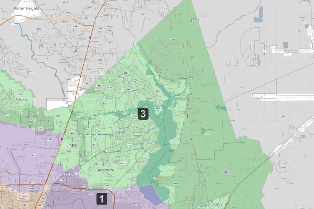
In the Ellis-3 Redistricting plan, almost all of the Lake Houston Area including Kingwood, Humble, Atascocita, Huffman and Crosby will change from Precinct 4 to Precinct 3. Tom Ramsey will remain the Commissioner of Precinct 3, and will not be up for re-election in 2022.
Details of Redistricting Plan
The Ellis redistricting plan swapped the numbers of Precincts 3 and 4. It also redrew the boundaries of Precincts 3 and 4 so that Ramsey’s home and Cagle’s home changed precincts. The Ellis plan has two immediate effects.
It forces Cagle and Ramsey, both Republicans, to run in each others’ precincts because commissioners must live in the precincts they represent.
The number swap will deny voters in the new precinct 3 the right to vote for commissioner in the next election. That’s because only even-numbered precincts will vote in the next election cycle for commissioners. So the Lake Houston Area will not be able to vote for commissioners next year as it normally would have.
In addition, the plan redraws boundaries of the new Precinct 4 so that it becomes more Democratic. That jeopardizes Cagle’s chances of re-election and could shift the balance of power in Commissioners Court. Four Democrats could create a super-majority, enabling them to raise taxes at will.
Judge Davis, who was supported in her election bid by Rodney Ellis, a key player in this drama, did not recuse herself. Nor did she cite any reasons for dismissing the case in her terse ruling.
Rodney Ellis and Judge Dedra Davis during her election bid.
Stage Set for Appeal
A spokesperson for Commissioner Jack Cagle’s office responded that the plaintiffs intend to file an appeal. However, because of the holidays, no other details were immediately available.
Posted by Bob Rehak on 12/23/2021
1577 Days since Hurricane Harvey
https://i0.wp.com/reduceflooding.com/wp-content/uploads/2021/11/20211117-Screen-Shot-2021-11-17-at-9.12.02-PM.jpg?fit=1200%2C798&ssl=17981200adminadmin2021-12-23 11:32:432021-12-23 11:49:51Redistricting Lawsuit Dismissed by Ellis-Backed Judge
The San Jacinto Regional Flood-Planning Group is soliciting nominations for a voting member position in the Small Business Category. The primary responsibility: to assist in the development of a regional flood plan for the San Jacinto Watershed.
The San Jacinto Regional Flood Planning Group meets monthly and is one of 15 such groups in Texas.
Nominees who have a strong affiliation or interest with small businesses are encouraged to apply. As the Small Business voting-member, this individual will represent all small businesses within the San Jacinto Flood Planning Group region, and act in their best interests.
Nominations may be made to the Region 6 – San Jacinto Regional Flood Planning Group Sponsor, Harris County Engineering Department, until Jan. 3, 2022 by 5:00 p.m.
Find the solicitation and application form on the SJRFPG website or at the link below:
Please complete the nomination form and email it to SanJacFldPG@eng.hctx.net or mail to the Harris County Engineering Department to:
ATTN: SJRFPG – Fatima Berrios
10555 Northwest Fwy, Suite 120
Houston, TX 77092.
For further information, please email SanJacFldPG@eng.hctx.net or call Fatima Berrios at (713)-274-3914.
Posted By Bob Rehak on December 22, 2021
1576 Days since Hurricane Harvey
https://i0.wp.com/reduceflooding.com/wp-content/uploads/2021/12/20211222-Screen-Shot-2021-12-22-at-3.15.56-PM.jpg?fit=973%2C1200&ssl=11200973adminadmin2021-12-22 15:40:292021-12-22 15:40:33Regional Flood-Planning Group Seeks Small-Business Member