Harris County Flood Control District (HCFCD) is accelerating its spending on flood mitigation projects. I compiled the chart below with data from a FOIA Request. This request parallels an earlier request at the end of the first quarter and includes spending through the end of the third quarter. In the 3.5 years since the flood bond, HCFCD has completed many preliminary studies and engineering designs. Now many projects are moving into the capital-intensive phases: Right-of-Way Acquisition and Construction.
Current Spending Rate is 8X over pre-Harvey Rate
Comparing the periods before and after Harvey, spending per month tripled. And comparing the last six months to the post-Harvey period, you can see that the pace accelerated another 2.75X. The average for the last six months is up a whopping 8X compared to the pre-Harvey period.
HCFCD Flood Mitigation spending is rapidly accelerating.
That’s good news.
Where/When Spending Occurred
The chart below shows where HCFCD has spent that money. It ranks watersheds by total spending. But within that, you can see tremendous variability between the pre- and post-Harvey eras. In some watersheds, such as Sims, HCFCD largely completed projects with its partners, before Harvey. In other watersheds, such as Little Cypress, you see the opposite. HCFCD accelerated spending on land acquisition as part of its Frontier Program to help prevent, rather than remediate flooding.
Looking at spending before and after Harvey shows the most watersheds ramping up spending as a few taper off.
Four Watersheds Have Received 53% of All Spending since 2000
The flood bond prioritization framework helps shape the curve above. It gives priority to low-income, socially vulnerable neighborhoods. Those projects started first while others wait.
Thus, most of projects in low-income watersheds cluster toward the left. Likewise, with a few exceptions, more affluent watersheds tend to cluster toward the right.
In the years ahead, as HCFCD completes more projects on the left and begins more projects on the right, the slope of the curve may change.
Spending continues to be concentrated in a handful of watersheds. Four have received more than half of all dollars since 2000.
In the meantime, however, looking at subsets of this data, reveals much about priorities. Only five watersheds out of 23 have been allocated significant dollars above the average.
If you took Cypress Creek out of that mix, four other watersheds would be at the average. And fourteen would be below it.
But the top four watersheds alone comprise 53% of all spending since 2000.
Additional Analysis to Follow
In the next few days, I will examine other aspects of spending and what drives it. Those other aspects will include, but are not limited to:
Where the most damage has occurred
Population density
Watershed size
Percent of low-to-moderate income residents
Partnership funding
More news to follow.
Posted by Bob Rehak on 12/9/2021
1563 Days since Hurricane Harvey
The thoughts expressed in this post represent opinions on matters of public concern and safety. They are protected by the First Amendment of the US Constitution and the Anti-SLAPP Statute of the Great State of Texas.
https://i0.wp.com/reduceflooding.com/wp-content/uploads/2021/12/Spending-Acceleration-Bar-Chart.jpeg?fit=1200%2C900&ssl=19001200adminadmin2021-12-09 15:31:072021-12-09 16:04:49HCFCD Accelerating Spending on Mitigation Projects
The City of Houston defended its permitting of the Kingwood Area’s first RV Park despite deficiencies in the process. The City claims the Laurel Springs RV resort meets old “grandfathered” standards. But concerned Lakewood Cove residents worry that the development does not meet current needs. They expressed concerns that:
Did not document the impact of overflow from that undersized pond in a two paragraph drainage impact analysis
Said that overflow from the undersized pond would be funneled toward Lakewood Cove despite a regulation requiring that excess stormwater not cross adjoining private property lines.
The amount of impervious cover in the plans did not change despite the addition of 25 percent more spaces.
The volume of the detention pond decreased during the review process.
The plans were not reviewed by a professional engineer (PE).
Below, read a summary of the City’s responses to each of these alleged deficiencies. To verify my summary, I’ve also included a PDF of the City’s entire response.
Filed False Info
The City did not really address this concern except to say that false information was filed by an agent who had no hand in the engineering. Apparently, filing false information under penalty of perjury is not an issue if you hire an agent.
Half the Detention Volume of Current Requirements
Despite getting the plans approved in October 2021, after detention requirements increased, the developer only had to meet 2020 requirements under a grandfathering clause based on the submission date (not the approval date) of the plans. So plans comply with the old requirements but not the current ones. Despite building a half-sized detention pond, the City still insists overflow won’t be a problem – except in a 100-year storm. The City ignores the fact that the pond is designed to hold a 100-year rain under older, lower standards.
Several of the 380 Elm Grove homes that flooded on May 7, 2019, and a City High Water Rescue Vehicle.
This is the same problem that happened in Woodridge Village, Elm Grove and North Kingwood Forest in 2019.
I’ve requested the full drainage impact analysis on three occasions. The City alludes to one, but still has not produced it. Instead, the City points to a two paragraph summary and seems satisfied with it. The City focuses primarily on the volume of water pumped into Lakewood Cove’s storm sewer system. It claims that if water overflows into people’s homes that will be due to a deficiency in how the Lakewood Cove lots were graded.
Where Will Overflow Go
The developer says that overflow from the undersized detention pond will go east toward Lakewood Cove (left in picture below) and then down a hill into Lakewood Cove’s detention pond near Hamblen Road. But the City says the opposite. It claims overflow will go west toward the Union Pacific railroad tracks (right in picture below). From there, sheet flow would go down into the County’s new Edgewater Park. The City did not express any concern about erosion of the track bed. But one wonders whether erosion could destabilize the railroad tracks which carry toxic chemicals.
Laurel Springs RV Resort next to UP Railroad tracks and Utility Easement. City says overflow from pond at far end of clearing will be funneled toward tracks, even though developer says the opposite.
Woodridge Village erosion caused by half of the estimated amount of a current 100-year rain.
Increase in RV Spaces
The developer changed the plans from 182 to 226 RV pads. The City approved with no further explanation. Nor did the City address the issue of a potential conflict with the permit.
No Increase in Impervious Cover
The City claims that when the number of spaces increased 25%, impervious cover did not and that calculations are still accurate. Public Works did not explain the apparent contradiction.
Decrease in Volume of Detention Pond
According to the City, the original detention-pond volume approved by the City must have been an “approximation” by the developer’s engineer. Even though the number decreased in final versions of the plans as the number of RV pads increased 25%, the City claims the developers still exceed the minimum detention requirements under the grandfathered 2020 regulations. They never address what will happen if rainfall exceeds 2020 assumptions, as it certainly will.
No Review by Professional Engineer
The City says reviewers work under the supervision of a professional engineer (PE), but PE’s do not actually review plans.
Summary
In summary, the City claims it didn’t make any mistakes. If homes flood, homeowners will be at fault because their sites must not be graded properly.
I wrote the City weeks ago about the potential erosion of the Union Pacific railroad tracks and still have not received a reply.
This seems to be a case of bureaucrats reviewing plans for literal compliance and ignoring the dangers of real-world deficiencies. If the higher requirements in 2021 regulations are not important, why did the City adopt them?
The thoughts expressed in this post represent opinions on matters of public concern and safety. They are protected by the First Amendment of the US Constitution and the Anti-SLAPP Statute of the Great State of Texas.
https://i0.wp.com/reduceflooding.com/wp-content/uploads/2021/12/20211205-DJI_0009-2.jpg?fit=1200%2C799&ssl=17991200adminadmin2021-12-08 13:13:182021-12-08 14:19:55City Defends RV Park Permit Despite Deficiencies
Since 2000, flood-mitigation spending in Harris County has topped $3 billion dollars. That’s through the end of the third quarter this year. Right of way (ROW) acquisition and construction represent the two largest components of that cost. ROW by itself consumed more than $1 billion and cost almost as much as construction. With saner building codes and floodplain regulations, we could have saved much of that for additional projects.
At the end of Q1, I made a Freedom of Information Act (FOIA) request to Harris County Flood Control District (HCFCD) for more than 20 years of financial records. I wanted to see how much we spent, where we spent it and what we spent it on. You can find the results on the funding page of this web site. I recently requested updated numbers through the end of the third quarter. While I haven’t finished analyzing the latest numbers yet, one thing leaped out at me immediately.
ROW Costs Virtually as Much as Construction
I knew the acquisition of property for large detention basins or channel expansions was expensive. However…
I had no idea that right-of-way acquisition cost HCFCD almost as much as construction of mitigation projects.
As you can see from the chart below, 36 percent of all HCFCD spending on mitigation projects goes toward the acquisition of Rights of Way (ROW). Forty percent goes toward construction. And 24 percent goes toward “all other.”
Based on data provided by HCFCD in response to a FOIA Request. Covers all capital improvement spending from 1/1/2000 through end of third quarter 2021.
What are Right-of-Way Costs?
Right-of-way costs represent the purchase of land on which HCFCD builds its projects. HCFCD can’t just build projects on someone else’s land. They need to acquire the land first. ROW acquisition can take years. Often people don’t want to leave homes and neighborhoods they may have grown up in…despite the flood risk.
Even with willing sellers, HCFCD must appraise the property, locate the owner, negotiate a price, close the sale, and demolish the property before doing anything.
Four and a half years after Harvey, about half of the Forest Cove Townhomes on Marina Drive remain standing but uninhabitable. They must all be torn down before HCFCD can revert the property to green space.
Buyouts of some properties elsewhere have taken a decade or longer.
Factors Affecting Percentages
Several factors affect the ROW percentage above.
When Projects Started
Projects that started recently may show a higher percentage of ROW costs, simply because construction may not have even started yet. Conversely, some projects that started in the 1990’s did not even have any ROW costs included in these numbers because they fell outside the period (2000 to 2021) of investigation.
Population Density
Population density also affects ROW acquisition costs. It’s more expensive to purchase land after development than before. For example, inner city land with apartments and high rises costs more than rural land. See below.
Brays Bayou at South Main near Texas Medical Center shows difficulty of expanding channels in developed areas.Photo May, 2021.
Type and Location of Density
Areas where people have built right next to the edge of bayous increase the cost of mitigation. They also increase the time it takes to complete projects. HCFCD had to buy out whole subdivisions along Halls Bayou in order to build the two giant detention ponds at US59 and Parker. The buyouts took three to five times longer than construction.
Note heaviest concentration of damage inside Beltway 8
Frontier Program
Counterbalancing that, HCFCD sometimes purchases large tracts of undeveloped land in rural areas as part of its Frontier Program. That enables HCFCD to build large regional flood mitigation projects in optimal locations at a lower cost per acre without the cost or delays of buyouts. HCFCD later resells detention pond capacity to developers to make its money back. The emphasis in the Frontier Program is on preventing flooding, rather than fixing it. That requires upfront investment. But it’s also a more humane approach because people aren’t flooding multiple times before HCFCD can acquire matching grants and take action.
Opportunity for Savings
If we could get developers to leave larger easements next to creeks and bayous, it could reduce ROW-acquisition costs in the long run. It could also enhance safety for residents and the reputation of developers. Wider ROW could be marketed as greenbelts and jogging trails – salable amenities. And people are usually willing to pay a premium for flood-safe homes. So this isn’t asking developers to be totally altruistic.
Would we save a billion dollars? No.
If you look at flood damage maps of Harris County, most flooding in the last 20 years has happened inside Beltway 8. We still need to fix much of that.
But going forward, the opportunity exists to reduce that 36% gradually to something more reasonable.
How much depends on whether you can make people in surrounding counties see the floods in their future if they don’t take action now. Flooding is already a significant issue in large parts of Montgomery and Liberty Counties. Perhaps that will motivate upstream interests to cooperate with downstream interests.
Posted by Bob Rehak on 12/7/2021 with grateful thanks to all the men and woman who fought at Pearl Harbor
1561 Days since Hurricane Harvey
https://i0.wp.com/reduceflooding.com/wp-content/uploads/2021/12/20210520-RJR_5210.jpg?fit=1200%2C753&ssl=17531200adminadmin2021-12-07 20:24:132021-12-07 20:41:12How to Save on Flood Mitigation
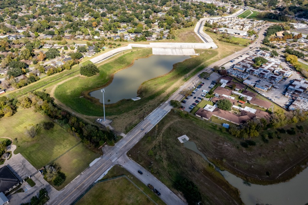
This is a story about implying you will do one thing and then doing the opposite. Like saying you will “take care to protect all vegetation” when you really intend to remove it all.
From the Stormwater Pollution Prevention Plan for the Laurel Springs RV Resort approved by the City of Houston.
Laurel Springs RV Resort as of 12/5/2021
Weasel Words as Getaway Vehicles
To pull off this feat of verbal legerdemain, some developers and engineers use “weasel words,” which are their “getaway vehicles.”
“Weasel words” are qualifiers that help to create a legal defense.
“…that does not need to be removed for construction purposes.”
Then they removed every tree, shrub and blade of grass on the site.
A Deceitful Charade
Developers all over Houston use this deceitful charade. And it’s time it stopped. If a developer has no intention of preserving any natural vegetation, the focus of stormwater pollution prevention plans should shift to other measures.
These developers DID promise to use silt fencing. And they actually installed some, but only on one side of the site.
So what’s to stop sediment carried by overland sheet flow from washing downhill into the beautiful cypress ponds that represent the signature feature of Harris County Precinct 4’s new Edgewater Park?
Laurel Springs RV Resort. “Look out below.”
Becoming Rule Rather than Exception
Developments like this have turned into the rule rather than the exception.
Not one of these developments would be fatal by itself. But taken together, we’re sowing the seeds of the next big flood. Trees consume rainwater and also slow runoff, reducing flood risk.
Posted by Bob Rehak on 12/6/21
1560 Days since Hurricane Harvey
The thoughts expressed in this post represent opinions on matters of public concern and safety. They are protected by the First Amendment of the US Constitution and the Anti-SLAPP Statute of the Great State of Texas.
https://i0.wp.com/reduceflooding.com/wp-content/uploads/2021/12/20211205-DJI_0998.jpg?fit=1200%2C799&ssl=17991200adminadmin2021-12-06 13:02:502021-12-06 15:36:07“…Care Will Be Taken to Protect All Vegetation…”
The new Kingwood Middle School is now being “glassed in,” at least the portions that are not brick. The glass will seal the interior from the weather outside and let new sets of contractors begin their work. Those include interior trades such as electricians, plumbers, painters, drywall, flooring and ceiling specialists. Since my last update on November 10, the contractors have made much progress. According to Humble ISD, the new school should open next August.
Once contractors have sealed the structure, the schedule no longer depends on weather and they can move much more quickly.
Multiple trades can work simultaneously in different parts of the building.
Progress in Photos
Here are pictures taken on 12/5/2021 that show the current status.
Approximately half of the exterior that will receive glass is already glassed in.
One of the entries. Exterior on right has not yet begun.
New Kingwood Middle School from over Woodland Hills Drive. The old school, right, will be torn down after this school year finishes.
Brickwork and roofing on the western portion of the building are almost complete. Some scaffolding remains for stonemasons on the opposite side of the building.
Construction moved from west to east. The eastern portions of the exteriors and roofing (right) are less finished.
Looking north to south. Once the old school is demolished (top of frame), athletic fields will be re-established in that area along with a permanent detention pond.
Looking SE at new Kingwood Middle School construction
The southeastern portion of the new Kingwood Middle School on Cedar Knolls still has a long way to go.
To compare previous monthly updates, search for “Kingwood Middle School”.
https://i0.wp.com/reduceflooding.com/wp-content/uploads/2021/12/20211205-DJI_0943.jpg?fit=1200%2C799&ssl=17991200adminadmin2021-12-05 20:29:302021-12-05 20:29:34December Update: Kingwood Middle School Being “Glassed In”
TxDOT’s Grand Parkway extension (a.k.a. State Highway 99) is rapidly moving east and south toward I-10. As it arcs around the northeast quadrant of the Houston Metro Area, it will open up vast new areas to development. Below is a map showing several already under development.
Yesterday, as I was photographing different areas near Huffman and New Caney near the San Jacinto East Fork, I captured these shots of the Grand Parkway extension and FM1485. The Grand Parkway is still under construction in this area, but it’s rapidly getting there.
SH99 and FM 1485, looking northeast toward Colony Ridge and Liberty County.SH 99 and FM 1485 looking north with San Jacinto East Fork running through middle of frame from top to bottom.SH 99 and FM 1485 Looking east over San Jacinto East Fork
I’ve taken shots of this area before and am fascinated by the difference in the spans of the bridges. Part of what you’re seeing is the difference between standards for Farm-to-Market Roads and State Highways. But you’re also looking at the consequence of an increase in expected rainfall rates, more upstream development, and learning from experience. FM1485 frequently goes under water nowadays.
Detention Pond under Bridge: Permanent?
One of the curious things I noticed yesterday was a large detention or sediment retention pond under the bridge. TxDOT has rerouted the East Fork around it as you can see in the first and second photos. I wonder if they will keep it as a large detention pond under the freeway when they complete construction. Or whether they will return the river to its normal course and plant trees between the two roads as you see in the distance.
Stay Away During Construction
Traffic detours through this area are a nightmare. Stay away if you can. It took me an hour to get from here to Kingwood yesterday via 1485, 494 and US59 at 2:30 pm. The distance: only 7 miles as the crow flies.
Posted by Bob Rehak on 12/4/2021
1558 Days since Hurricane Harvey and 776 since Imelda
https://i0.wp.com/reduceflooding.com/wp-content/uploads/2021/12/20211203-DJI_0936.jpg?fit=1200%2C799&ssl=17991200adminadmin2021-12-04 21:06:442021-12-04 21:06:47Grand Parkway Extension is Getting There
Dredging Location as of 10/12/2021. East Fork at Mouth of Luce Bayou on right.From here, pontoons ferry the spoils back to the West Fork opposite Kingwood’s River Grove Park.East Fork Dredging as of 12/3/2021. Photo taken from Huffman side of river looking SW toward Royal Shores and the FM 1960 Bridge in the distance.
Since then, the dredgers have managed to remove about 300 feet of the tip of one sandbar blocking the mouth of Luce Bayou and Red Gully (on the left in the shot above).
Looking upstream. Lots of dredging left to do. Between Harvey and Imelda, the sandbars in this area grew approximately 4000 feet.
Note the sediment plume in the middle of the boat’s wake above. That indicates the shallowness of the river.
According to boater Josh Alberson, the depth through this reach of the river was reduced from 17 feet to about three feet between Harvey and Imelda.
Dredging: A Conveyance Issue
The dredging is far more than a recreational issue. The decreased conveyance of the river creates a sediment dam than backs water up and contributes to the flooding of homes. In fact, I passed by dozens of flooded and abandoned homes while looking for a place to launch my drone.
Mechanical Vs. Hydraulic Dredging
One can only wonder whether the City of Houston is using the right tools for the job. Even Stephen Costello, Houston’s Chief Recovery Officer, called mechanical dredging “unsustainable in the long run” when he addressed a crowd at the Kingwood Community Center on July 9.
But it may come down to a case of slow-go or no-go.
I asked a friend in the dredging business to estimate the costs of mechanical vs. hydraulic dredging. He qualified the discussion by saying that:
To even consider hydraulic dredging you need a pit to pump the material into.
He also suggested that to reduce long-term overhead costs, you want to be able to use the equipment year round and create a perpetual dredging program.
He said the ideal would be to go once around the lake and arrive back at the beginning when it was time to start all over again.
That said, he estimated that hydraulic dredging was 10X faster and one third to one fourth the cost of mechanical dredging.
With hydraulic dredging, the upfront equipment and setup costs are far higher. Mechanical dredging is far slower and more expensive.
I won’t pretend that I have the answer to the question of which is better in this case: mechanical or hydraulic.
Vendor for Long-Range Dredging Plan Due to Be Selected This Month
The submission deadline for vendors bidding on a long range dredging plan for Lake Houston was 9/23. The Request for Qualifications stated that the City hoped to put contract approval on the City Council Agenda for December and start the contract in January. The selected vendor will have two years to complete the dredging plan.
It could easily take that long to finish the East Fork Mouth Bar at the current rate.
Posted by Bob Rehak on 12/3/2021
1557 Days since Hurricane Harvey and 775 since Imelda
https://i0.wp.com/reduceflooding.com/wp-content/uploads/2021/12/20211203-DJI_0925.jpg?fit=1200%2C799&ssl=17991200adminadmin2021-12-03 18:28:162021-12-04 07:27:39Slow-Go: East Fork Dredging Still at Mouth of Luce Bayou
Stormwater detention basins work by storing excess stormwater temporarily until channels can safely carry it away. Water enters the basin quickly during heavy downpours. But the basin releases it slowly at a steady rate that channels are designed to carry. This helps reduce the risk of flooding.
Harris County is so flat that dams are not often options. Therefore, virtually all of our stormwater storage has to be excavated.
Harris County Flood Control District
Willow Water Hole Example
The Harris County Flood Control District (HCFCD) detention basins typically cover several hundred acres and service regions. Willow Water Hole just outside the southwest corner of Loop 610 on a tributary of Brays Bayou is an excellent example.
The 279-acre Willow Waterhole has six compartments. Willow is part of the Brays Bayou Federal Flood Damage Reduction Project (Project Brays), a multi-year, $550 million project that substantially reduces flooding risk in the Brays Bayou watershed. The project is a cooperative effort between the Harris County Flood Control District and the U.S. Army Corps of Engineers.
Willow Waterhole Detention Basin Complex in SW Houston has six compartments.
Why the Need?
As areas develop, buildings and concrete cover up soil, so stormwater can’t sink into the ground. Water runs off concrete faster than it does from native grasslands. When that water all hits channels, streams and bayous simultaneously from different directions, it exceeds the carrying capacity of the channel. And homes flood.
Many, but not all, new developments use stormwater detention basins to offset that negative effect.
When full, detention basins often resemble lakes. When dry, detention basins look like large excavated open space areas. The Willow Water Hole is normally dry. Yesterday, however, it contained water from recent rains and the low (seasonal rate of evaporation).
Two of the compartments bracket South Willow Drive. See location above. Note the weir (discussed below) leading to the channel.
Some systems have water in them permanently, so they resemble small lakes. These provide flood storage between the normal surface of the lake and the top of the bank. See the difference in the photograph below.
Willow Water Hole southwestern pond. Note extra capacity between the top of the water and the top of the banks.
Detention? Retention? Which is It?
A detention basin normally has a dry bottom. It holds excess stormwater temporarily.
A retention basin always has a wet bottom. It stores water indefinitely. Retention basis normally have no outlet. Evaporation and infiltration usually keep the lake levels manageable.
The Harris County Flood Control District always builds and uses detention basins. Developers more likely will use retention ponds and market the resulting “lakes” as residential amenities.
HCFCD owns approximately 70 large regional detention basin sites throughout Harris County. They supplement hundreds of smaller developer-built basins. Countywide, these basins hold billions of gallons of stormwater during heavy rainstorms.
Two northeastern retention ponds within Willow Water Hole complexon either side of South Post Oak Road.
How Water Gets In
Sometimes HCFCD designs stormwater detention basins with a weir (visible in the first and second drone photos above). The weir, or low dam, lets stormwater rising in the channel spill into the detention basin when it reaches a certain height. Other detention basins have no weirs. They are simply open to a channel. In this case, stormwater fills the basin as it rises in the channel.
But there’s also a third alternative for stormwater detention basins, i.e., those not near a channel. Storm sewers and/or sheet flow fill these detention basins. “Big pipes in – little pipes out” is the rule in this instance. The basin gets the water away from streets and homes quickly. Then lets it drain off slowly.
How Water Gets Out
HCFCD typically designs detention basins to drain by gravity, as opposed to using pumps. This lets basins function when power goes out, a frequent occurrence during floods.
In ponds that drain by gravity, depth of the drain (outfall) is dictated by the depth of the receiving channel. The rate at which stormwater drains depends on the stormwater level in the receiving channel. Typically, stormwater drains out of the detention basin after channel levels recede.
Complex engineering calculations determine the volume of stormwater that a detention basin must hold to protect surrounding homes and businesses. That volume, usually measured in acre-feet, determines the width, length and depth of a basin. The amount of time stormwater stays in a basin depends on levels in the receiving channel and how full the basin got. In Harris County, detention time is usually measured in hours, not days.
How the Process Works
Normal Flow
When there is normal flow in a bayou or channel, the detention basin is generally empty.
Initial Storm Effects
Basins begin to fill as bayous or channels rise, or as surrounding developments drain into them through storm sewers.
Capturing the Flow of a Heavy Storm
As water continues to fill the detention basin, it spreads out into the excavated area. Often culverts connect multiple “compartments” within a larger basin, as above.
Detaining the Flow
By holding water in the detention basin, it does not flood homes and businesses downstream.
Draining Detained Water
As the level of the channel recedes, the channel water level drops and lets the basin drain, but only as fast as the channel can handle it.
Back to Normal Flow
With the water level in the channel normal, the basin is once again empty and ready for the next rainstorm.
End Result
Often, HCFCD partners with local groups, such as the Houston Parks Board, to build trails around these ponds that provide a retreat from busy city life. Areas such as Willow Water Hole also provide habitat for birds. People out for a stroll or a jog may think they are in a beautiful park and not even realize the role it plays in reducing flood risk.
The City of Houston has scheduled a repaving project for West Lake Houston Parkway from Dec. 6-27, 2021. This is a bit off-topic for a flood blog, but it affects thousands of readers. This follows several previous repaving and bridge repair projects on West Lake Houston Parkway. The following is based on a press release by Mayor Pro Tem Dave Martin’s office.
Mayor Pro Tem Dave Martin would like to make Kingwood area residents aware Houston Public Works will start a panel replacement project on West Lake Houston Parkway beginning Monday, December 6, weather permitting.
The scope of work includes replacing damaged concrete panels along the north and southbound lanes of W Lake Houston Parkway from Kingwood Drive to Magnolia Cove Drive.
The cost of the project is $38,200 and is funded through Mayor Pro Tem Martin’s Council District Service Funds.
Crews will mobilize on-site beginning Monday, December 6 and should finish the project by Monday, December 27, weather permitting.
Construction activities are expected to take place Monday through Friday from 8:00 a.m. to 5:00 p.m., and on Saturdays from 7:00 a.m. to 12:00 p.m.
Please stay alert for flagmen and orange traffic cones that will help traffic flow through the construction zone. The project may require a one-lane closure at times, but two-way traffic will be maintained at all times.
Businesses and residents will have access to driveways and sidewalks at all times, but may experience an increase in noise levels.
On the Harris County Commissioner’s Court agenda for today are two Harris County Flood Control District (HCFCD) “transmittals.” One will update commissioners on flood-bond spending to date. The other will update commissioners on the progress of new flood maps (the MAAPnext program). They are items 269 and 270 on today’s agenda.
Transmittals are reports by departments. Commissioners don’t usually discuss them unless one of the commissioners wishes to make comments for some reason. So, I’m calling them to your attention here.
Flood-Mitigation Spending Through Third Quarter Reaches $865 Million
About half of the $865 million spent on flood mitigation since voters passed the bond in 2018 has come from bond funds. The rest has come from grants and local partnerships. See pie chart below on left.
The left pie chart underscores the importance of partnership funding.
The map below shows where flood-bond spending has occurred.
Flood-mitigation spending by watershed since approval of flood-bond in 2018.
The winner in the $weep$take$: HCFCD spent almost $154 million on Brays Bayou.
Other leading watersheds (rounded to nearest million) in flood-bond spending included:
$81 million in Addicks Reservoir
$76 million on Greens Bayou
$76 million on Cypress Creek
$50 million on Little Cypress Creek
$46 million on White Oak Bayou
$32 million on Clear Creek
With a few exceptions, this spending reflects the influence of the Harris County Flood-Bond Equity Prioritization Framework implemented in 2019. That framework gives highest priority to low- to middle-income watersheds with a high social-vulnerability index. Thus, tiny Halls Bayou has received more assistance than the largest watershed in the county – the San Jacinto River. And Brays Bayou has received almost 11 times more assistance than Buffalo Bayou.
Two notable exceptions are:
Vince Bayou which is almost totally inside the City of Pasadena and is therefore primarily Pasadena’s responsibility.
Little Cypress Creek which is part of HCFCD’s experimental Frontier Program. The Frontier Program aims to prevent future flooding by buying up land on the cheap before it’s developed. HCFCD then sells detention basin capacity to developers to help make back its investment.
Other Insights Gained from Report
Most projects are ahead of schedule and on budget. Good news!
More than half of buyouts have been completed and enough funding apparently remains to complete the rest.
Progress continues on the $124 million FEDERAL Flood Damage Reduction project on White Oak Bayou, where six stormwater detention basins will hold almost a billion gallons of stormwater. That’s equivalent to about a foot of stormwater falling over almost 5 square miles.
An earlier version of this report generated some controversy. People in some watersheds didn’t believe the reported expenditures. Members of the Northeast Action Collective questioned whether any projects had started in their watersheds. They demanded immediate cancellation of projects in Kingwood and transfer of Kingwood’s funds, so that projects in Halls and Greens Bayou could start immediately.
That’s, in part, why I wrote “How to Find and Verify Flood-Related Information: Part I.” Flood-mitigation projects are hard to spot from the ground. Construction almost always happens out of sight behind tall fences and dense tree lines. After construction, the projects are often disguised as parks. For those who doubt, I recommend confirming the existence of projects from the air.
I haven’t confirmed every project in the county, but I have spot-checked many. And I have yet to find discrepancies between what HCFCD reports and what I can see from the air.
C-25, a Halls Bayou Detention pond now under construction by HCFCD. The bayou runs through the trees in the foreground.New basin at Hopper and US59 on a tributary of Halls Bayou.Lauder Detention Basin on Greens Bayou as of 10/12/2021. Phase One of a two-phase project is nearly complete.Cutten Road detention basin on Greens Bayou continues its relentless expansion.Phase 1 of the Greens Bayou Aldine-Westfield Basin on left is complete. Phase 2 on right is now beginning.
For more information that includes watershed spending data before the flood-bond, check out the funding page.
MAAPnext Effort About to Be Turned Over to FEMA
Harris County Flood Control (HCFCD) estimates it has completed 86% of its part of the flood-map updates. HCFCD will deliver drafts of the new maps to FEMA in January for review and kick off a campaign of public meetings at the same time. The public will see draft maps in February. A public comment period of 90 days will follow. And FEMA hopes to release preliminary flood insurance insurance rate maps by mid-year next year.
I have had a peek at the new maps and reports. And I must say, the effort should result in a dramatic leap forward in flood-risk understanding. Individualized reports will inform homeowners of their flood risks from a variety of different sources, including street flooding. The prototype of the website is very user friendly.
After receiving preliminary maps from HCFCD, it typically takes FEMA another 18-24 months to release final, official flood maps. That gives affected property owners time to comment and appeal. The process looks like this.
MAAPnext milestones as of the end of 2021.
Posted by Bob Rehak on 11/30/2021
1554 Days since Hurricane Harvey
https://i0.wp.com/reduceflooding.com/wp-content/uploads/2021/11/20211130-Screen-Shot-2021-11-30-at-10.31.04-AM-2.jpg?fit=1200%2C836&ssl=18361200adminadmin2021-11-30 12:47:472021-11-30 12:47:51Where Flood-Bond Spending Is Going, When New Flood Maps Will Be Released