Lawsuit Alleges Harris County’s Ellis-3 Redistricting Plan is Unconstitutional
A lawsuit filed yesterday with the Harris County District Clerk alleges the Ellis-3 Redistricting Plan adopted in the Harris County Commissioners Court Meeting on 10/28/21 is unconstitutional. The Ellis-3 plan would deny virtually everyone in the Lake Houston Area the ability to vote in the next county commissioner election. If allowed to stand, the plan also has the potential to affect all aspects of county government from flood mitigation to services and taxation. Below is a summary of the lawsuit. See the entire lawsuit here.
Basis For and Goals of Suit
The lawsuit claims the Ellis-3 Plan, which renumbered precincts in addition to redrawing them, disenfranchises more than 1.1 million people of their right to vote in next year’s Harris County elections.

Plaintiffs in the lawsuit include Republican Commissioners Tom Ramsey in Precinct 3 and Jack Cagle in Precinct 4. The suit names County Judge Lina Hidalgo and Harris County as defendants. Significantly, defendants may be barred from asserting governmental immunity under a legal principle called ultra vires and the Texas Declaratory Judgments Act. “Ultra vires” describes an act which requires legal authority, but is done without it.
The plaintiffs seek a temporary restraining order and injunctive relief that bars the County from using the Ellis-3 plan for the upcoming 2022 election cycle for Harris County Commissioner elections. Plaintiffs also seek to extend the filing period for new candidates and incumbents until after the lawsuit is resolved.
Suit Claims Ellis-3 Plan Deprives 1,125,937 People of Right to Vote
One of the most significant features of the Ellis-3 Plan was that it moved more than a million voters between even- and odd-numbered precincts. In Texas, when people vote for county commissioners depends on whether they live in even- or odd-numbered precincts.
Even-numbered precincts will vote in the 2022 election cycle and odd-numbered precincts will vote in 2024. So when Ellis flipped the numbers for Precincts 3 and 4, he “illegally and unconstitutionally” stripped 1,125,937 Harris County voters of the right to vote in the next election, according to the suit.
The Texas Constitution established the odd/even rules in 1954 through an amendment which also staggered the initial terms of Commissioners, thus ensuring half would be elected every two years.
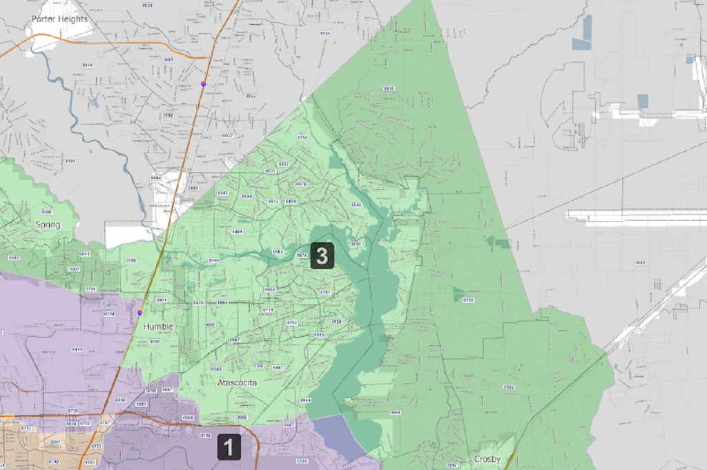
Virtually all registered voters in the heavily Republican Lake Houston Area would be deprived of their right to vote for commissioners in the next County election.

The Ellis-3 Plan moves voters from even-numbered precincts into odd-numbered precincts as follows:
- 7,192 move from Precinct 2 to l
- 139,434 move from Precinct 2 to 3
- 215,142 move from Precinct 4 to 1
- 764,169 move from Precinct 4 to 3.
Accordingly, last month’s adoption of the Ellis-3 Plan will prevent more more than 1.1 million people from voting in the next election who otherwise would have voted. The lawsuit calls that “a total and complete abrogation of their constitutionally mandated right to vote.”
17.71% Disparity in Population Made Redistricting Necessary
The lawsuit acknowledges that redistricting was necessary. Under state law, precincts are supposed to have equal-sized populations…or as close as you can get. But in no event should variation from the ideal exceed 10%.
However, prior to redistricting, unequal population growth between 2010 and 2020 exceeded that 10% maximum.
2020 Census data on the Harris County Attorney’s website shows precinct populations varied from the “equal-sized” ideal by the following percentages:
- P1 -0.36%
- P2 -10.47%
- P3 +7.24%
- P4 +3.59%
That created a population disparity of 17.71% between the largest and smallest precincts, almost double the amount allowed under state law.
2 Million Move Precincts when 200 Thousand Would Have Sufficed
However, the lawsuit also claims that the Ellis-3 Plan moved 2.2 million between precincts (both odd- and even-numbered) when constitutional requirements could have been met by moving only 201,713.
Plaintiffs also claim that they have created a “demonstration map” where population deviations were addressed but ZERO citizens lost their right to vote in the next election. (However, Plaintiff’s did not include that map with their legal filing.)
Plaintiffs offer a simple explanation for why excessive shifting occurred. They assert that “Commissioner Ellis wanted to do whatever it would take to draw a new map that would create three (3) Democratic seats.”
The original petition claims, “…the Ellis 3 Plan does just that.”
- “It maintains Ellis’ Precinct I as a reliably Democratic district, making sure that Latino voting strength is too weak to beat him in a primary election, especially given the African-American support he enjoys in that precinct regardless.”
- “It strengthens Precinct2’s democratic strength in the hopes that Commissioner Adrian Garcia can withstand a general election challenge by a Republican.”
- “It packs Republicans into Precinct 3, such that the likelihood of Commissioner Ramsey being reelected is high.”
- “By strengthening the Republican voting strength of Precinct 3, the consequence is to flip the likely partisan nature of Precinct 4 from Republican to Democrat.”
But to do all that, the lawsuit alleges, the Ellis-3 Plan disenfranchised 1.1 million innocent voters.
While generally mocking the lawsuit, even the left-leaning Houston Chronicle admitted today that, “The adopted Ellis map gives Democrats a 50 percentage advantage over Republicans in Precinct 1, 12 points in Precinct 2 and 12 points in Precinct 4.”
The Chronicle continued, “The endgame is that the Democrats can secure a 4-1 majority, which will give them the freedom to set tax rates with a quorum of four members and avoid a minority of two Republicans sitting out and derailing the vote.
Lawsuit Chances
Not one of the experts interviewed by the Chronicle writer gave the suit a snowball’s chance. One dismissed it as “political theater.”
But neither did the Chronicle mention that the Judge assigned to the case, Dedra Davis, was supported by Rodney Ellis in her last election bid.
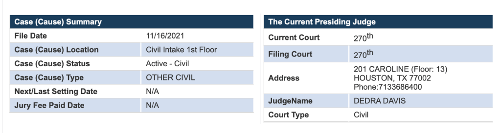
One Harris County insider who spoke on condition of anonymity said, “She is one of the judges Ellis got elected. There are several of them. The lawsuit has no chance. They will have to appeal up to a higher court.”
A second person sent me this photo. It validates the insider report.

Perhaps Davis will recuse herself since Ellis is the lead actor in this drama. Not recusing herself would seem to create grounds for an appeal. Here is the Texas law governing recusal of District Court judges.
Posted by Bob Rehak on 11/17/2021 and modified on 11/18 with addition photo of Ellis and the Judge in his case.
1541 Days since Hurricane Harvey
The thoughts expressed in this post represent opinions on matters of public concern and safety. They are protected by the First Amendment of the US Constitution and the Anti-SLAPP Statute of the Great State of Texas.


