Then the agent signed it under the words, “I UNDERSTAND AND AGREE that if any fact stated in this Declaration is false, the City may void any permit(s) issued by the City for the Project, and the City may order the Owner or its successor to remove all or part of the Project at my or our own expense. I declare under penalty of perjury the foregoing is true and correct.”
Serious Lack of Attention to Detail for Legal Doc
See the signed document below with red highlights added to help focus on the mistakes.
Mistakes in owners’ declaration of support.Red emphasis added.
So what should the right entries have been?
The Plat, HCAD and Deed all say “W Massey” not “S Massey.”
Address is Laurel Springs Lane, not Road.
Laurel Springs Lane is in Kingwood, not Huffman.
77339 is a zip code, not the name of the owner.
Detail from approved plat.Note name of original survey in red highlighted area.
Symptomatic of Other Mistakes?
You would have to be in a particularly uncharitable frame of mind to impose sanctions based on the careless mistakes above. But they show a distinct lack of attention to detail that raises more serious questions about all of the plans and potential mistakes in other documents.
This does not inspire confidence. But it should inspire an investigation into the details of all the plans and how they got approved.
Two Site Plans Show 24% Difference in Number of RV Spots
That’s a 24% increase in the amount of impervious cover. And that could seriously affect drainage calculations. But the permit still calls for 182.
The drainage mitigation plans do not specify how many spots the drainage calculations are based on. What’s the final number?
This could be one of the reasons why the developer and contractor refuse to meet with neighbors to discuss their plans. Do they know of flaws in other docs, too?
Cavalier Attitude to Penalties of Perjury
Geez! This developer does not pay much attention to detail under possible penalties of perjury, project cancellation and personal financial ruin. I wonder how many mistakes other documents contain that don’t carry those penalties.
The person who filed the Declaration of Support for the permit is Leslie B. Mickelis. Mickelis lists her address as 12320 Barker Cypress, Suite 600. That’s a PostNet store. According to the Secretary of State, Mickelis operated a company called Texas State Permits LLC, which lost its right to do business in Texas due to a tax forfeiture in 2009.
All of this raises serious questions of public safety and concern.
We need Houston Public Works – or a neutral third-party engineer – to review the plans from beginning to end for consistency and accuracy.
Posted by Bob Rehak on 11/6/2021and updated with additional information about Mickelis on 11/7/2021 thanks to a tip from Daryl Lombard
1530 Days since Hurricane Harvey
The thoughts expressed in this post represent opinions on matters of public concern and safety. They are protected by the First Amendment of the US Constitution and the Anti-SLAPP Statute of the Great State of Texas.
https://i0.wp.com/reduceflooding.com/wp-content/uploads/2021/11/Flaws-in-App-copy.png?fit=1200%2C766&ssl=17661200adminadmin2021-11-05 23:22:122021-11-07 12:59:45Multiple Mistakes Found in Supporting Doc for RV Park Permit App. What Lurks in Others?
The primary contractor responsible for building the Kingwood area’s first RV Park has six tax forfeitures in his past. And the Secretary of State indicates that he has not filed public information reports (PIRs) associated with Texas franchise tax since 2019 for two more of his companies involved in developing the RV park. They are Higbie Ventures LP and Higbie Ventures of Texas, Inc.
The most recent PIRs on file with the Texas Secretary of State are dated April and September of 2019, more than two years ago.
Filing PIR reports is an annual requirement in Texas for business entities.
According to the Secretary of State’s database, Higbie Ventures, LP has not filed a PIR beyond 2019. Note also that the partnership previously forfeited its right to do business in Texas for seven years due to non-filing of reports (see below). However, it was later reinstated.
Note gap between 2009 and 2016. Screen capture from TX SOS Direct on 10/28/21.
I called the Texas Secretary of State (SOS) to confirm that the department’s records for Higbie were current. The lady I talked to said they were, but urged me to call the State Comptroller’s office to see if a new batch of updates was coming soon.
The State Controller’s office could not tell me when new updates were being sent to the Secretary of State. She also refused to discuss the company’s filing history except to say that their status was currently “active.”
The Comptroller’s office, however, did confirm that companies and partnerships had to file PIRs every year. No one could explain the contradiction between active status and apparent non-filing.
Higbie Ventures of Texas, Inc. the Primary Operator At Construction Site
The Texas Commission on Environmental Quality (TCEQ) Stormwater Pollution Prevention Permit at the Laurel Springs RV Park construction site shows Higbie Ventures of Texas, Inc. as the primary operator of the construction site.
Permit posted on Construction Site as of 10/29/21.
Yet this company’s most recent PIR was filed in September 2019 according to the Secretary of State.
Screen Capture from Texas SOS Direct website on 10/30/2021shows no reports filed for 2020 or 2021. Reports are due by May 15.
It’s unclear why Higbie or the owners needed more than one Higbie entity involved in this job.
13 Higbie Companies, Six Tax Forfeitures, One PO Box
Texas Secretary of State records show that William S. Higbie has started at least 13 companies or partnerships in Texas. Five are still active. They include:
Higbie Ventures, LP (formed 2003)
Higbie Ventures GP, LLC (formed 2003)
Higbie Ventures of Texas, Inc. (formed 2010)
Cherry Branch Enterprises LLC (formed 2006)
Higbie Residential Ventures of Texas, Inc. (formed 2014)
Higbie lost six in tax forfeitures and voluntarily dissolved two others. They include:
Higbie Builders GP, LLC (Tax Forfeiture 2006, later reinstated)
Zentrum Construction Company (Tax Forfeiture – 2007 )
WM-GP, Inc. (Tax Forfeiture –2007)
1318 GP, Inc. (Tax Forfeiture – 2007)
1318 Birdsall LTD (Tax Forfeiture – 2009)
Birdbath GP, Inc. (Tax Forfeiture – 2009)
Higbie Roth, Inc. (Voluntarily dissolved – 2002)
Higbie Roth Construction Company (Voluntarily Dissolved – 2013)
Higbie may have other business interests in Florida that are not shown here.
No Offices Currently Listed for Higbie
Eight of the 13 Higbie entities above are or were registered to PMB 1007 (Private Mail Box 1007) at 3733 Westheimer. Google Street View shows a Post & Parcel store there.
Higbie uses that same box for ALL of his active companies or partnerships in Texas.
This may indicate that none of Higbie’s Texas companies has a regular office.
Apparently, No Websites Either
At this time, Higbie does not appear to have a website of his own or for any of his ventures. I cannot find one.
A website called HigbiePlans.com DOES exist, but Higbie has no company by that name. Nor is one registered in the State of Texas.
A footnote on the HigbiePlans website says, “Online planroom powered by ReproConnect and Best Blue Print.” WhoIs.com shows that Best Blue Print actually owns the domain called “HigbiePlans.com.” To boost its own business, Best Blue Print appears to host websites like HigbiePlans as a courtesy to architects, builders, contractors, and others who may require prints of oversized files.
The HigbiePlans.com pages for Higbie Ventures shows one phone number that has been handed down from one Higbie company to another over the years, according to Google searches.
Very little information can be found about William S. Higbie or his organizations online.
Primary Operator?
The TCEQ permit posted at the RV park job site shows that Higbie Ventures of Texas, Inc. is the primary operator.
Another company, A&M Contractors, appears to be doing the actual work which the TCEQ thinks Higbie is doing and which Higbie purchased the permits for.
Signs on construction equipment at the site show that A&M Contractors appears to be doing the work that Higbie’s companies obtained permits for.
While it is not unusual for companies in the construction business to hire subcontractors, it is unusual for an owner of a site to hire two (or three) companies to do the same thing. That runs up costs without adding value. And RV Parks are among the most cost-sensitive types of construction, according to developers I interviewed for this post.
Low Profile, High Failure Rates
I’m not alleging anything illegal or even unethical about Higbie or his organizations.
He just keeps an exceedingly low profile for a business man. And he has an exceedingly high failure rate. His Texas business ventures have failed at an alarming 62% rate.
Eight of his 13 entities in Texas have gone out of business, and six of the eight were lost to tax forfeitures.
In construction, when large dollars are at risk, that’s not the kind of track record that inspires confidence among lenders and investors.
Several Lakewood residents say they have tried to meet with Higbie about the RV park, but that Higbie doesn’t answer his phone. No wonder he’s so successful.
Will the real William S. Higbie please stand up?
Next, more on the owners of the RV Park. They operate more than 100 different companies.
Posted by Bob Rehak on 11/4/2021
1529 Days since Hurricane Harvey
The thoughts expressed in this post represent opinions on matters of public concern and safety. They are protected by the First Amendment of the US Constitution and the Anti-SLAPP Statute of the Great State of Texas.
https://i0.wp.com/reduceflooding.com/wp-content/uploads/2021/11/Screen-Shot-2021-10-28-at-10.08.03-AM.png?fit=2478%2C896&ssl=18962478adminadmin2021-11-05 01:27:422021-11-05 10:23:26Contractor Behind Kingwood’s First RV Park Has Six Tax Forfeitures In His Past
Morgan Lumbley, Montgomery County’s Disaster Recovery Manager, will hold community outreach meetings in Spring, Conroe and Splendora in the next 10 days to explain buyout options for flood victims. “It is my hope that through positive engagement we can provide the ability for homeowners to relocate out of harm’s way,” said Lumbley.
See specifics about times, dates and places in the poster below.
Anybody in Montgomery County may attend any meeting. Choose the most convenient.
The primary purpose of the meetings will be to explain FEMA’s 2021 Flood Mitigation Assistance (FMA) program, but Lumbley will also explain HUD’s Community Development Block Grant Disaster Recovery (CDBG-DR) buyout program.
If you’re a Montgomery County resident and you’ve ever wondered whether you qualified for a buyout, whether you could get fair compensation for your home, or how you could apply, these meetings are for you.
The meetings will cover:
Who qualifies (eligibility requirements)
For which type of assistance (FEMA vs. HUD)
How long it takes
The application process
How homes are valued
How to get help filling out the forms if you need it
Importance of Meetings and Timing
Lumbley described the meetings as community outreach. She needs to identify properties owners interested in buyouts and determine their eligibility. Once she does that, she will apply to FEMA for an FMA grant (Flood Mitigation Assistance) equal to the total value of all homes that quality.
The application process happens once a year. If interested, learn how to apply now.
The FEMA Flood Mitigation Assistance Grant basically has two requirements.
It has to be a severe repetitive loss or a just a repetitive loss property, as indicated by the National Flood Insurance Program (NFIP).
You must currently have a NFIP policy backed by FEMA. Private insurance is not eligible.
Lumbley cautions that getting a buyout can take years. “It’s not a tomorrow-type thing,” she said. “We may not have anything final for another year and a half to two years. So we’ll talk about that first. Then realizing that some may not qualify for FEMA’s program, we will also talk about HUD buyouts.”
FEMA Applications Due Back November 15th
Once Lumbley determines the number of homes that meet requirements, she will build a budget around those eligible homes. “We are basically saying to FEMA, ‘If you give us this money, these are the homes that we’re going to buy out. That’s how we establish the budget.”
“It all comes down to how many eligible individuals want to participate,” said Lumbley. “We will submit the county’s application to FEMA with five or a 100 homes.”
Definitions of Repetitive Loss and Severe Repetitive Loss
“Very specific definitions exist for repetitive loss and severe repetitive loss properties,” she said. “A repetitive loss property has had flood related damage on two occasions in which the cost of repairs averaged together equal or exceed 25 percent of the market value of the structure – at the time of the floods.Severe repetitive loss properties have had four or more separate floods, with each claim being $5000 or more. And at least two of those claims have to be within a 10 year period.”
“Another way to qualify as a severe repetitive loss is to have at least two separate NFIP claims that that total more than the market value of the structure,” she added.
Valuation
“We will write the county’s 2021 FEMA grant application to reflect current market value of homes. If FEMA approves that, applicants would get whatever the competitive open market value is on the day that the appraiser goes out to appraise it.”
HUD grants are based on pre-disaster valuation. “So it goes back to the disaster on which funding is based,” said Lumbley. “We’re currently working off the 2015/2016 floods and Hurricane Harvey. So what value did the home have before the storm hit, minus any funding that the owner might have received that did not go back into the home as it was intended?”
Eligible Years Vary by Type of Grant
Community Development Block Grants from HUD are disaster specific. So to be eligible for a HUD grant, you must have been damaged during one of those ‘funded storms,’ such as 2015, 2016 or Harvey.
But FEMA FMA grants are not disaster based. So as long as you have a current NFIP backed flood insurance policy and you meet the definitions of repetitive loss or a severe repetitive loss, you could to be eligible. For instance, maybe you flooded four times in 1978, 1982, 1994 and 2001.”
it gets complicated. If you’re interested in a buyout, the time to explore it is now – at one of these meetings – and the person to ask is Lumbley.
If you know someone interested in a buyout, make sure he/she attends one of these meetings. Please share this post with others in Montgomery County.
Posted by Bob Rehak on 11/3/2021 based on information from Morgan Lumbley
1527 Days since Hurricane Harvey
https://i0.wp.com/reduceflooding.com/wp-content/uploads/2021/11/20211027-image0.jpg?fit=1200%2C1006&ssl=110061200adminadmin2021-11-03 18:41:462021-11-03 20:23:45Montgomery County Holding Three Meetings for Flood Victims Interested in Buyouts
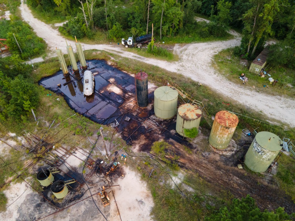
The Texas Railroad Commission (TRRC) had been making good progress on cleaning up the abandoned oil field between the Forest Cove Little League fields and the San Jacinto West Fork. However, it recently stepped back from the job when the mineral owners signed an agreement with a new operator to acquire several orphan wells.
Harvey’s Toxic Legacy
Floods from Hurricane Harvey destroyed the field and then the operator at the time, Noxxe Oil & Gas, went bankrupt. The company with a joke name (Exxon spelled backwards) turned out to be anything but a joke. It left behind a toxic legacy on the shores of Lake Houston, the source of drinking water for more than 2 million people.
New Activity Spotted at Site
A company called Southcoast Production, Inc. recently put a sign up at the entrance and began taking heavy equipment into the site.
From the air, I spotted what appears to be a workover rig pulling pipe at one of the old well sites.
The rig photographed yesterday was apparently pulling corroded pipe.Photo from May 26, 2021 shows location of new work.
Huge Improvement, But Some Work Yet to Do
When the new operator took over the lease, the TRRC ceased its cleanup and plugging operations to let the new operator bring the site into compliance. The cleanup isn’t quite done yet. But whoever has been cleaning this site up, it looks and smells far better than it did last year.
“Before” photo from June of 2020.Photo taken 11/1/2021 of same area but with wider lens.The blue/green storage tanks in the upper right are new.
Turning the Pumps Back On
Centerpoint recently brought electricity to the site so Southcoast could begin operating pumpjacks again.
It’s good to see someone taking responsibility for this oil field. In its post-Harvey condition, it was an environmental catastrophe.
Thanks to the TRRC and State Representative Dan Huberty for helping to accelerate the cleanup effort.
Posted by Bob Rehak on 11/2/2021
1526 Days since Hurricane Harvey
The thoughts expressed in this post represent opinions on matters of public concern and safety. They are protected by the First Amendment of the US Constitution and the Anti-SLAPP Statute of the Great State of Texas.
https://i0.wp.com/reduceflooding.com/wp-content/uploads/2021/11/20211101-DJI_0670.jpg?fit=1200%2C799&ssl=17991200adminadmin2021-11-02 17:07:192021-11-03 11:44:26Oil Field South of Forest Cove Little League Fields Producing Again
The Kingwood Service Association pier at the River Grove Park Boat Launch has reached the end of its service life and is being replaced.
The pier, which had grown old, sustained damage during recent floods. The planks had so much give in them, that I often wondered if they would hold me.
It’s Finally Time
After Harvey, though, KSA had so much work to do in the park – removing sand, replacing pavement, fixing fields, restoring restrooms, and dredging in front of the boardwalk – that replacement of the pier just had to wait, according to Dee Price, KSA president.
Earlier this year, KSA had a professional engineer draw up specs and then it solicited bids. “The winning bid was affordable and the contractor is doing excellent work,” said Price.
I would second that from everything I saw today at the park. Both the wood and workmanship appear top notch. This will make an excellent addition to the park.
Pics of New Pier Under Construction
Driving new piles to extend the pier. The four poles stabilize the boat while the pile driver in the center does its work.From this angle, you can more easily see how the pile driver slides forward and backward on rails to ensure alignment of supports.From ground level, you can see how substantial the wood is.
Expected Completion Soon
Price says she expects the work to be done this week or next, depending on weather. The launch remains open in the meantime, but is blocked periodically for short periods by the pile driver as you see here.
Posted by Bob Rehak on 11/2/2021
1526 Days after Hurricane Harvey
https://i0.wp.com/reduceflooding.com/wp-content/uploads/2021/11/20211101-DJI_0655.jpg?fit=1200%2C799&ssl=17991200adminadmin2021-11-01 21:44:062021-11-01 21:44:10KSA Replacing River Grove Boat-Launch Pier
One of the most popular natural attractions in the north Houston area is the Spring Creek Greenway. But between mile marker 8 and 8.5, a large new development called Breckenridge East has cut across the trail, leaving a massive scar through the forest to accommodate its drainage.
Nature Interrupted
Since 1979, Harris County Precinct 4 commissioners have added to the beautiful trail system between I-69 and I-45. The Spring Creek Greenway currently connects and protects approximately 7,000 acres of forest in Harris County, preserving this ecological gem as a mecca for ecotourism, education, and outdoor recreation.
But yesterday, a reader and cyclist, Ken Matthews, alerted me to an issue.
Photo by Ken Matthews on 10/31/2021. Taken from Spring Creek Greenway looking toward new development.NE portion of development from the air. Oval indicates where it cuts across greenway.Spring Creek cuts through top of frame from left to right.
Role of Forests in Flood Prevention
According to Harris County Precinct 4 and Harris County Flood Control District:
Forests buffer against flooding by absorbing rainfall in their canopies and in the soil.
Trees act as natural water filters and significantly slow the movement of storm water, which lowers runoff, soil erosion, and flooding.
From an economic viewpoint, communities that use this important function of trees and canopy cover may spend less money on other flood control methods.
Infiltration rates for forested areas are 10-15 times greater than for equivalent areas of turf and grass.
Harris County Flood Control District
Recipe for Runoff
In the shot above, you can see the beginning of what looks like a large detention pond. But as we saw with Woodridge Village flooding in 2019, putting in the detention ponds AFTER the land has been cleared can be a recipe for runaway runoff during big storms.
Lush forest replaced by vast expanse of sterile nothingness.Entire development. A local resident told me that during Harvey, water came up to Cypresswood Drive in the lower left. That put this entire area underwater.Breckenridge East is in far upper left. Another development a little more than a block away is also cutting into the forest. Cypresswood Drive in foreground.Looking NW from second development across Planet Ford Stadium toward Breckenridge East, one can see a whole series of developments starting to encroach on the Spring Creek floodplain and greenway.
Reach from Highway 249 in Tomball east to US 59 in Kingwood, and
Cover more than 12,000 acres.
Please support the Bayou Land Conservancy. They preserve land along streams for flood control, clean water, and wildlife. Not to mention future generations.
Posted by Bob Rehak on 11/1/2021 with thanks to Harris County Precinct 4, Bayou Land Conservancy and Ken Matthews
1425 Days since Hurricane Harvey
The thoughts expressed in this post represent opinions on matters of public concern and safety. They are protected by the First Amendment of the US Constitution and the Anti-SLAPP Statute of the Great State of Texas.
https://i0.wp.com/reduceflooding.com/wp-content/uploads/2021/11/DJI_0645.jpg?fit=1200%2C799&ssl=17991200adminadmin2021-11-01 09:07:532021-11-01 13:32:51Spring Creek Greenway Threatened by New Development
Imagine you’re getting on an airplane and you see someone popping rivets out of the wing. You ask the pilot, “What’s that guy doing!?”
The pilot says, “Oh, he’s popping rivets. Our accountants have found that can eliminate weight and improve fuel economy.”
“But won’t that increase risk?” you ask.
The pilot replies, “Somewhat, but our engineers believe it won’t bring the plane down.”
Would you get on that airplane? Would you live in this proposed development? Or downstream from it? See details below.
Details of Northpark South
Here are the plans presented to the Planning Commission last Thursday for a plat of Northpark South. The commission deferred action on them until the next meeting. The developer is Hannover Estates, LTD. RG Miller engineered the development.
Pretty location!Just don’t let your kids go fishing there.
Of course, the homes will be built on the highest ground. But look how far the floodplain (dotted line) cuts into them.
Northpark South floodplains. Of course, these are based on 1980s data. Don’t be fooled by the data on the map. That’s the date of the background image. In Harris County, the new flood maps will reportedly expand the floodplains by 50% as a rule of thumb. But this is MoCoand the last update was much longer ago.
Here’s how that area looked during Harvey.
US Fish & Wildlife Service Map of wetlands (and former wetlands) on the site (center of frame).
Looking W from over end of Northpark Drive. Sorters-McClellan cuts through bottom of frame from left to right. West Fork cuts through sand mines in the background.
The barren spot just right of center is the wetland area that will be filled in to make home sites.
Meet the neighbors.
Where the subdivision drainage will go…straight into the West Fork.
Water flowed so quickly through this area during Harvey that it moved and sunk this excavator within the mine.
Another Development Targeted at the Uninitiated?
The shame of it is that if Northpark South gets built, the developer will likely build starter homes and market them to couples with young children. They’re the least knowledgeable about flood risk.
Posted by Bob Rehak on 10/31/2021with thanks to Paul Ehrlich for the parable and Mai Truong for the heads up on this
1524 Days since Hurricane Harvey
The thoughts expressed in this post represent opinions on matters of public concern and safety. They are protected by the First Amendment of the US Constitution and the Anti-SLAPP Statute of the Great State of Texas.
https://i0.wp.com/reduceflooding.com/wp-content/uploads/2021/10/20211031-DJI_0631.jpg?fit=1200%2C800&ssl=18001200adminadmin2021-10-31 19:31:372021-11-01 17:50:50More West Fork Wetlands near Northpark Drive Could Soon Be Developed
Last week, I started getting barraged by emails from stunned Lakewood Cove residents waking up to the sound of bulldozers and chainsaws. Someone was cutting down 22 acres of trees between them and the Union Pacific Railroad tracks that parallel Loop 494 – for an RV park – without any public notice.
I went to the site on Monday and started investigating. On Wednesday, I posted what I had learned. Then I kept researching. Half a day on Thursday. All day Friday. And all day Saturday. It’s like digging into a House of Mirrors. But it’s no funhouse. There are so many legal entities with so many similar names that it’s easy to confuse them. That may be the intention.
For instance, you might think that Higbie Ventures LP is the same as Higbie Ventures GP LLC or Higbie Ventures of Texas, Inc. Likewise, you might think Laurel Springs RV is the same as LS RV Resort. But it’s not an abbreviation. They play different roles. But what are they?
So Many Questions, So Little Time
The deeper I dig into the shadowy web of contractors, managers, and investors behind this venture, the more questions I had.
According to residents who have tried to contact them, they refuse to answer questions or meet with the affected community. Why?
The City of Houston Planning Commission, Public Works Department and District E office have not returned phone calls or emails. Why?
The Harris County Appraisal District website contains incomplete and dated records about the land. Why?
The Harris County Flood Control District said they were not given an opportunity to review the plans even though part of the property is in the flood plain of the San Jacinto West Fork.
The City permits for the work show a different legal entity than the TCEQ stormwater permit. Why?
According to the Secretary of State’s website, the two organizations supposedly responsible for the clearing haven’t filed franchise-tax public-information reports in more than two years – but are somehow still doing business in the State of Texas. Why?
Could that affect the validity of the building permits?
The contractor responsible for the clearing (according to the TCEQ permit) has NO website, and has apparently subcontracted the work to another company. Why?
The man behind the primary contractor has started at least 11 companies or partnerships in Texas. None have websites. Most operate out of a PO Box. Most use the same phone number. He’s lost four of the entities to tax forfeitures and dissolved two others. What’s going on there?
And the people who own the property operate a maze of more than 100 other partnerships and corporations. Will they keep and manage the property or sell it to investors?
How will:
The property be managed and marketed? Who will it cater to?
The RV park affect drainage in Lakewood Cove next door?
Heavy vehicles affect the streets?
The absence of trees affect train noise?
Trees Mostly Gone
Just before sundown tonight, I went back to see how many trees remained. And the answer was, “not many.” They seem to have cleared virtually the entire site with the exception of the southern end where the detention pond will go. There’s also a strip of trees about two trees wide next to the utility corridor that parallels the railroad tracks. Next to Laurel Springs, that narrows to one tree in some places and zero in others.
At this point, the battle to save the trees is over. They will all disappear faster than you can say “injunction.”
The developer has executed a perfect blitzkrieg attack that would make Hitler jealous.
Below are pictures taken on Saturday, 10/30/2021.
Looking SSE. Lakewood Cove on left. UP tracks run from bottom to top on right.
Detention pond will go approximately where red box is.
At this rate, clearing could be completed in a week or two.
Location of Project
For those of you who don’t know where Lakewood Cove is, see below. It’s the area immediately to the right of the red. Friendswood Development Company never owned this land, so it’s not technically a part of “Kingwood,” which is a Friendswood trademark. Therefore, it doesn’t legally enjoy the protection of Kingwood’s deed restrictions. However, in every other sense, it is very much a part of the Kingwood community.
Location of land being cleared for new RV Park is in red. Land between the red and the river will become Harris County Precinct 4’s new Edgewater Park.
Posted by Bob Rehak on 10/30/2021and revised on 10/31/2021 to include the “Location of Project” information immediately above.
1523 Days Since Hurricane Harvey
The thoughts expressed in this post represent opinions on matters of public concern and safety. They are protected by the First Amendment of the US Constitution and the Anti-SLAPP Statute of the Great State of Texas.
https://i0.wp.com/reduceflooding.com/wp-content/uploads/2021/10/20211030-DJI_0615.jpg?fit=1200%2C799&ssl=17991200adminadmin2021-10-30 21:03:472021-11-11 17:33:03In One Week, More Questions than Trees Remain at Site of First Kingwood RV Park
In a straight party-line vote, Harris County Judge Lina Hidalgo, Precinct 1 Commissioner Rodney Ellis and and Precinct 2 Commissioner Adrian Garcia approved a modified version of a plan presented weeks ago by Ellis. It contained an even bigger surprise than in Ellis’ original plan. And it takes gerrymandering to a whole new personal level that really strikes home.
The Old Switcheroo
The plan approved on 10/28/2021 creates two safe, predominantly Democratic precincts for Ellis and Garcia while forcing Republicans Cagle and Ramsey to run in each other’s precincts where they are relatively unknown. That will mean Republicans will have to raise and spend more money to compensate for low awareness.
County law specifies that precinct commissioners must livein the precincts they represent. Currently Ramsey lives in and represents Precinct 3; Cagle lives in and represents Precinct 4. So Ellis carefully gerrymandered the boundaries of the new Precinct 3 to include Cagle’s home and the new Precinct 4 to include Ramsey’s.
That means both Republicans would have to move their homes in order to represent their current districts.
Hidalgo Calls It Payback for Not Raising Taxes
Judge Lina Hidalgo supported the last minute entry in the redistricting sweepstakes. When Cagle questioned why, she said it was payback for Republican’s walking out and blocking a tax increase earlier this year. A tax increase must be approved by a 4-1 supermajority. So when Cagle and Ramsey walked out of the meeting, Democrats did not have the votes they needed.
The map below will now define the new precinct boundaries. The other major change: Garcia’s Precinct 2 loses the heavily Republican far northeast portion of the county. That will shore up his re-election chances. Last time, he won by just 2,000 votes and his seat was widely regarded as the most vulnerable in this election, given the old precinct boundaries.
The redistricting map adopted today by Harris County. Lines represent old boundaries. Colors represent new boundaries. Ellis switched the numbers 3 and 4.
Cities and counties without healthy checks and balances can devolve into blatant political corruption. The next election could determine the tenor of politics in Harris County for decades to come.
The next Harris County election will be the primary in May.
Posted by Bob Rehak on 10/28/2021
1521 Days after Hurricane Harvey
The thoughts expressed in this post represent opinions on matters of public concern and safety. They are protected by the First Amendment of the US Constitution and the Anti-SLAPP Statute of the Great State of Texas.
https://i0.wp.com/reduceflooding.com/wp-content/uploads/2021/10/Ellis-3-Final_Page_1-copy.jpg?fit=1200%2C927&ssl=19271200adminadmin2021-10-28 19:21:322021-10-29 07:47:28Democrats Approve Modified Ellis Redistricting Plan Along Party Lines
Higbie Ventures LP, a construction company headquartered at 3733 Westheimer, has started clearing more than 20 acres immediately north of Harris County Precinct 4’s new Edgewater Park at US59 and the San Jacinto West Fork for a recreational vehicle park that would hold 182 RVs. The land sits between the Union Pacific Railroad Tracks and Lakewood Cove just west of Laurel Springs Drive.
Looking S from over Union Pacific tracks on right. Lakewood Cove on left. Edgewater Park is the big treed area to the left of the railroad tracks in the distance.Photo taken 10/26/2021.
Goodbye Towering Pines, Hello Oleander
Landscaping plans indicate that the company will clear all the trees that buffer neighbors to the east from the noise of freight trains. Oleander would replace the towering pines. Oleander is pretty but poisonous. It’s toxic to humans and pets if even small amounts are ingested.
Neighbors’ Fears
Neighbors worry about how a nearby RV park could impact their home values, safety and quiet neighborhood traffic patterns. They generate a lot of heavy vehicle traffic that streets weren’t designed for. And the RV owners sometimes also decide to become permanent residents.
This could disrupt replenishment cycles of the cypress ponds in Edgewater Park which will be one of the signature attractions of the park.
Moreover, even though part of the property sits in the floodplain, Harris County Flood Control says it was not given an opportunity to review the plans. And the floodplains shown on the plans correspond to a pre-Atlas 14 era with rainfall amounts roughly 28% lower than today’s.
It’s unclear how Higbie got permits without a public notice. But at a meeting of 150 Lakewood Cove residents last week, not one could remember receiving a notice about the RV Park development.
However, the City of Houston Permitting site shows eight permits issued to the developer for the RV Park.
The plan documents posted on the contractor’s website claim that ALL have received permits from the City of Houston, though they do not show permit stamps, only that they have been reviewed for compliance.
The permits above apply to site work only, not the construction of buildings on the site. These permits relate to site clearing, paving, sidewalks and utilities. However, there don’t appear to be any permits related to actual buildings shown on their plans.
Even though one of the permits shown in a database search is labeled “Building Pmt,” the actual permit says it is for “Structures Other than Buildings.” See below.
The “building permit” associated with the Higbie site says its for structures other than buildings.
Planned Buildings Not Yet Shown on COH Permit Site
The City of Houston District E office has not responded to enquires about whether the site is fully permitted or why the plans do not show permit stamps by city engineers.
Drone Photos Show Extent of Clearing To Date
Drone photos show the contractor has already cleared a large area on the northern portion of the site and is working south. These show the extent of clearing as of 10/26/2021.
Looking NW at site. Lakewood Cove in lower right. RV Park in Center. Lowes in upper right. US59 cuts across top of frame.Looking S again. Site clearing is moving south. The southern edge of the RV Park will roughly parallel the southern extent of homes in this photo. Looking N. The northern end of the site also roughly parallels the northern end of Lakewood Cove. So all homes in the subdivision would be affected.Contractor is leaving trees around the perimeter for now, but the landscaping plan calls for them to eventually be replaced by oleander.
Park Plan Update
Dennis Johnston, Harris County Precinct 4 Parks Director was kind enough to supply these most recent plans for Edgewater Park. The RV park would be above the black line at the top of the frame below. This first image shows trails within and around the park as well as an alternate route to connect Hamblen Road with the bridge over US59 leading to the Sorters-McClellan bridge. The alternate route would provide a way for traffic to avoid blind turns onto 494.
More than 160 Lakewood Cove residents have already signed a petition protesting the RV park. But it’s not clear whether anything can be done at this point to affect the developer’s plan. Neither the developer, Laurel Springs RV, LLC nor contractor have responded to pleas for meetings with residents according to one community leader that I have talked to.
This development raises many questions. I sincerely hope the developer choses to engage with the community to answer neighbor’s questions.
Posted by Bob Rehak on 10/28/2021and updated 10/29/2021 to reflect a difference between the contractor and developer.
1520 Days since Hurricane Harvey
The thoughts expressed in this post represent opinions on matters of public concern and safety. They are protected by the First Amendment of the US Constitution and the Anti-SLAPP Statute of the Great State of Texas.
https://i0.wp.com/reduceflooding.com/wp-content/uploads/2021/10/20211025-DJI_0596-1.jpg?fit=1200%2C799&ssl=17991200adminadmin2021-10-27 20:37:052021-10-28 13:48:36RV Park Developer Clearing Land Near Site of Precinct 4’s New Edgewater Park