Eye of Nicholas Reforms, Timetable Moved Up
8am CDT, 9/13/2021
According to Harris County meteorologist Jeff Lindner, “The center of Nicholas has reformed overnight about 150 miles to the northwest of the previous center or just off the tip of the northeast Mexican coast. With the center reformation, the track timing has been moved up by about 12 hours.”


Nicholas will now make landfall along the middle Texas coast later this afternoon or this evening.
National Hurricane Center
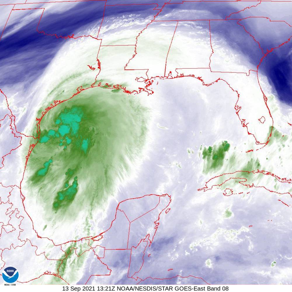
Said Lindner, “The center is now clearly defined on Brownsville radar and has been sampled by a USAF mission. The latest mission has found that the central pressure is starting to fall and is down to 1001 mb. Maximum sustained winds now reach 60mph. A large mass of very deep convection now extends several hundred miles into the Gulf of Mexico. Nicholas is moving toward the NNW around 14mph and will pass just offshore of Brownsville this morning. This will be a significant rainfall event for southeast Texas.”
Watches and Warnings Now in Effect
- A Tropical Storm Warning is in effect for…
- Mouth of the Rio Grande to High Island Texas
- Barra el Mezquital to the U.S./Mexico border
- A Tropical Storm Watch is in effect for…
- East of High Island Texas to Sabine Pass
- A Hurricane Watch is in effect for…
- Port Aransas to Freeport Texas
- Flash Flood Watch is in effect for:
- Areas along and SE of US 59
- A Storm Surge Warning is in effect for…
- Port Aransas to San Luis Pass Texas
- Aransas Bay, San Antonio Bay, and Matagorda Bay
- Storm Surge Watch is in effect for…
- Mouth of the Rio Grande to Port Aransas Texas
- San Luis Pass Texas to Rutherford Beach Louisiana, including Galveston Bay
- Baffin Bay and Corpus Christi Bay
Track
Forecasters predict a general northward motion toward the Matagorda Bay area followed by a gradual turn toward the NNE and NE. The forward motion of Nicholas will slow after moving inland over the TX coast.

Intensity
Radar shows the Nicholas is attempting to form an inner core. However, moderate wind shear and dry air reaching into the center have slowed this process. With that said, Nicholas is now moving over very warm waters. Lindner predicts the shear may weaken over the next 8-10 hours. That may let Nicholas intensify close to hurricane strength at landfall. Nicholas should make landfall as a strong tropical storm or minimal hurricane.
Tropical storm force winds currently extend outward 115 miles…mainly to the east of the center.

Impacts
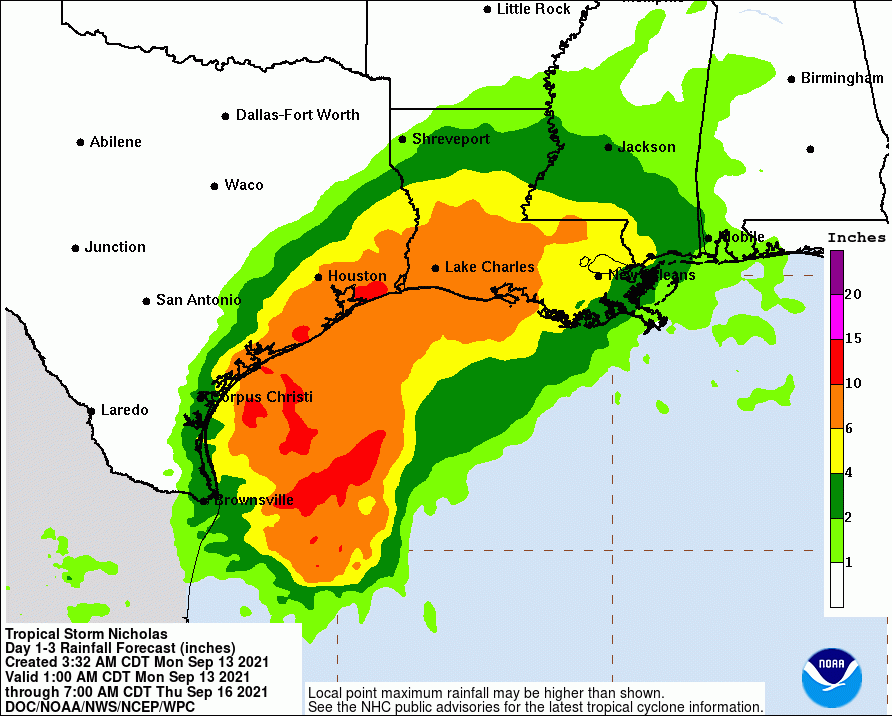
Rainfall:
Significant rainfall is expected along and east of the track of Nicholas. This rainfall may produce areas of considerable flash and urban flooding, especially in highly urbanized metropolitan areas. Additionally, there is the potential for isolated minor to moderate river flooding.
While rainfall totals are indicated over the 5 -7 day period, much of the rainfall is expected to fall over a 2-3 day period starting later tonight.
- Coastal counties: widespread 10-15 inches (isolated totals up to 20 inches)
- South/East of US 59: widespread 8-12 inches (isolated totals up to 15 inches)
- North of I-10: widespread 4-6 inches (isolated totals up to 8 inches)
After landfall, models do not aon how quickly the tropical cyclone will move northeastward out of Texas. The forward speed is important to the heavy rainfall forecast, and this trend will be one to watch.
The usually conservative Space City Weather team warns that the flood threat in this event may compare to Tropical Storm Imelda and the 2016 Memorial Day weekend.

Winds:
Tropical storm force winds are likely along the coast from Matagorda to Galveston Bay and inland to the US 59 corridor. Sustained winds in the 65-75mph range will be possible over the Matagorda Bay region northward into Jackson and possibly southern Wharton Counties with sustained tropical storm force winds spreading inland into portions of Harris, Fort Bend, and Colorado Counties.

Maximum sustained winds are currently near 60 mph (95 km/h) with higher gusts. Strengthening is forecast today, and Nicholas could reach the northwest Gulf coast as a hurricane. Weakening is anticipated on Tuesday and Wednesday while Nicholas moves over land.
Tropical-storm-force winds extend outward up to 115 miles (185 km) from the center. South Padre Island recently reported a wind gust to 45 mph.
Tropical storm conditions are expected to first reach southern Texas this morning, making outside preparations difficult or dangerous. These conditions will spread northward within the warning area through tonight. Hurricane conditions are possible in the Hurricane Watch area as early as this afternoon. Tropical storm conditions are possible within the watch area by tonight or early Tuesday.
Tides:
Expect storm surge of 3-5 feet from Port O Connor to Sargent and 2-4 feet from Sargent to High Island above normal dry ground. Some significant inundation is possible around Matagorda Bay. Additionally, waves on top of the surge will result in significant beach erosion and wave run-up.

Gradual Weakening Predicted
Nicholas should weaken after landfall, diminish into a tropical depression within a couple of days, and degenerate into a remnant low in about 3 days.
Key Messages
- Heavy rainfall will impact portions of the Texas and Louisiana coasts through the middle of the week. Significant rainfall amounts are possible, potentially resulting in areas of considerable flash and urban flooding, especially in highly urbanized metropolitan areas. Isolated minor to moderate river flooding is also expected.
- There is the danger of life-threatening storm surge inundation along the coast of Texas from Port Aransas to San Luis Pass. Residents in these areas should follow any advice given by local officials.
- Nicholas is forecast to approach the middle Texas coast as a strong tropical storm today, and could be near hurricane intensity at landfall. Tropical storm conditions are expected along portions of the middle Texas coast beginning by this afternoon, with hurricane conditions possible from Port Aransas to Freeport this afternoon and tonight.
- Tropical storm conditions are expected along portions of the northeastern coast of Mexico and the coast of south Texas beginning during the next few hours.
Posted by Bob Rehak on 9/13/2021 at 8AM based on information from HCFCD and NHC
1476 Days since Hurricane Harvey
