This is a bit off topic, but it affects tens of thousands of readers. City of Houston Mayor Pro Tem Dave Martin has announced street repairs in Kingwood and Huffman beginning on March 20.
Kingwood Repairs
In Kingwood, the Public Works Department will replace concrete panels in the westbound lanes of Kingwood Drive between Green Oak and Chestnut Ridge. Repairs should last, weather permitting through May 8 and cost $175,000 from Martin’s District Service Funds. Crews will work Monday through Friday from 8 a.m. to 5 p.m. and Saturday from 7 a.m. to 12 p.m.
Kingwood Drive repairs will extend from Green Oak to Chestnut Ridge Drives.
Huffman Repairs
In Huffman, Public Works will rehab the asphalt streets in Lakewood Heights as part of Mayor Turner’s Street Rehab Initiative. Crews will work from Monday through Saturday from 7 a.m. to 4:30 p.m.
Lakewood Heights in Huffman
More About the Work
Kingwood repairs should take through May 8. Huffman repairs should take through May 22, weather permitting.
Flagmen and orange traffic cones will help with traffic flow through both construction zones as the projects will require a one-lane closure. Two-way traffic will be maintained at all times. Businesses and residents will have access to driveways and sidewalks at all times and may experience an increase in noise levels due to trucks and equipment in the area.
For more information, please contact Mayor Pro Tem Dave Martin’s office at (832) 393-3008 or districte@houstontx.gov.
Posted by Bob Rehak on 3/19/22 based on notices from CoH District E
2028 Days since Hurricane Harvey
https://i0.wp.com/reduceflooding.com/wp-content/uploads/2023/03/Kingwood-Drive-Repairs.jpg?fit=1796%2C994&ssl=19941796adminadmin2023-03-19 13:22:152023-03-19 13:22:17Street Repairs in Kingwood, Huffman Begin March 20
State Representative Charles Cunningham has introduced HB1093. The bill would ensure cleanup of abandoned sand mines in the San Jacinto watershed. It requires miners to post a bond that covers cleanup costs. So, if an irresponsible miner walks away from a mine before reclamation, the public doesn’t have to pay the deadbeat’s costs.
A bond is like an insurance policy that guarantees the performance of obligations.
Without a bond, miners who profited for years from a mine can simply walk away when they are done mining, foisting cleanup costs onto the public or leaving blight behind.
How Bad Is the Problem?
Right now, there are at least six mines on the East and West Forks of the San Jacinto that were left a mess. Such abandoned sand mines are increasingly becoming a blight that imperils water quality in Lake Houston, the source of drinking water for 2 million people.
Rusting equipment leaks poisons and poses safety problems.
Un-stabilized soil increases rates of erosion and contributes to flooding.
Steep banks in pits slump away in slabs threatening neighboring properties and businesses.
Blight reduces surrounding property values and business activity
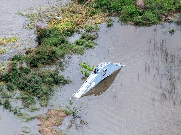
Miners are supposed to remove equipment and structures before they abandon a mine. But not all do. See the pictures below.
Leaking equipment near Riverview Drive in Porter on West Fork. Google Earth images show thisin same location since 2008.Dredge abandoned in Humble mine in 2017.Abandoned excavator in Porter mine on West ForkAbandoned dredge in Plum Grove mine.Abandoned processing equipment in Humble mine.Abandoned processing equipment and vehicle in Humble mine since 2017.
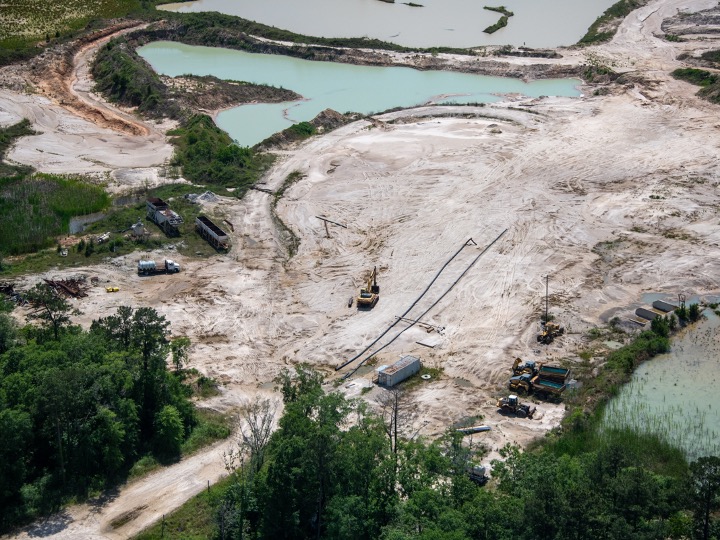
Miners are also obligated to grade and stabilize soil before they leave a mine, then replant vegetation similar to the surrounding area to reduce sediment pollution. But not all do.
Ungraded, un-stabilized soil in East Fork Plum Grove Mine.Ungraded soil and abandoned equipment in East Fork MineA flood later swept through the mine above, sending sediment down the East Fork.Defunct sand pit in Humble. Steep slopes – ungraded and unvegetated – erode and threaten neighboring business.
Community Consequences
Most sand moves during storms. This island appeared after Hurricane Harvey between Humble and Kingwood. It blocked the West Fork by 90%, according to the Army Corps and contributed to the flooding of thousands of homes and businesses.Confluence of the San Jacinto West Fork with Spring Creek. Images taken on different days from different angles, but in each case the dirty water comes from the West Fork, where we have 20 square miles of mines on a 20 mile stretch of the river between I-45 and I-69.
Most responsible miners will clean up on their own. But experience shows, a few bad apples will not. And when they walk away, the cost to the public can be enormous. Dredging costs alone have exceeded $226 million in the Lake Houston area since Harvey.
How You Can Help
Please help reduce this and related cleanup costs in the future. Ensure that sand miners don’t pass their remediation costs on to taxpayers.
Make sure HB1093 at least gets to the House floor for a vote this year.
The committee will likely recommend King’s HB10. It will fund the creation of 7-million acre-feet of new water supplies for rural areas.
Let’s do something that won’t cost taxpayers a penny to protect a water supply we already have. Support HB1093. And please forward this link to all your friends, family and neighbors.
Posted by Bob Rehak on 3/18/23
2027 Days after Hurricane Harvey
The thoughts expressed in this post represent opinions on matters of public concern and safety. They are protected by the First Amendment of the US Constitution and the Anti-SLAPP Statute of the Great State of Texas.
https://i0.wp.com/reduceflooding.com/wp-content/uploads/2023/03/20200306-RJR_9442.jpg?fit=1200%2C800&ssl=18001200adminadmin2023-03-18 09:23:232023-03-18 09:53:52Urgent Request: Support HB1093 to Improve Water Quality, Reduce Flooding, Save Tax Dollars
Today, it wasn’t Republicans vs. Democrats. It was humans helping humans. And how refreshing it was!
86-Year Old, Mobility-Challenged Woman Gets New Home, New Life
Texas General Land Office (GLO) Commissioner Dawn Buckingham and her staff gathered to turn over the keys to the newly rebuilt home of Earnestine Henry. Ms. Henry is an 86-year old African-American great grandmother who relies on a wheelchair and walker to get around. Hurricane Harvey displaced her from the 79-year old home she owned for 50 years.
Neighbors, friends and family – the entire street – all joined in the festivities. It was the 1000th such home that the GLO built in Houston and Harris County in the last two years.
When Commissioner Buckingham gave Ms. Henry a bouquet of flowers as a housewarming gift, Ms. Henry began to cry tears of joy.
Henry left, Buckingham right.
Then, the deeply religious Henry threw up her arm and went silent for a second.
Finally, she shouted “Thank you, Lord.”
She was so overcome with emotion that Commissioner Buckingham reached out to steady her in case she started to fall.
The room went silent as she sobbed and dried her tears. Everyone else dried theirs, too, including seasoned journalists. Yes, even I sniffled.
Then Ms. Henry flashed a beatific smile. The gracious and grateful octogenarian then took her guests on a tour of her new home as she thanked all the GLO staff in attendance.
She never thought she would recover from Harveyand couldn’t believe her beautiful new surroundings.
Before/After Photos
Here’s what the home looked like before the rebuild.
And here’s what it looked like today, including the handicapped ramp. All homes built through the GLO’s Homeowner Assistance plan meet the needs of the residents with mobility challenges. Not only is the homeowner’s investment protected, their safety is as well.
Ms. Henry had originally applied to the City of Houston for help after Harvey, but reportedly never heard back. Her daughter and granddaughter helped her reapply to the GLO when the GLO took over the program in 2021.
Better, Safer
JW Turner Construction built the new home, which is fully code compliant and energy efficient. The rebuild happened as part of the GLO’s Homeowner Assistance Program (HAP).
In accordance with federal law and City of Houston codes, new homes located in a flood plain are elevated to 2 feet above base flood elevation.
Property Values Increase, but Not Taxes
On average, homes rebuilt through the Homeowner Assistance Program increase the value of the property by more than $85,765. To address concerns about increased property taxes, in 2019 the Texas Legislature passed Senate Bill 812 to protect homeowners from drastic increases after the GLO reconstructs homes.
The GLO’s Homeowner Assistance Program reaches the hardest hit, low- and moderate-income, vulnerable families and individuals.
1000th Rebuild Part of a Continuing Effort
Of all approved applicants, nearly 90 percent identify as Black or Hispanic. 89 percent are considered low-to-moderate income. And 63 percent make less than 30 percent of the area median income.
The GLO currently has another 1000 homes under construction in the Houston area.
“No other state or territory has performed like Texas in the recovery from Harvey,” said Buckingham. “A large part of that credit goes to the GLO. In two years, GLO has rebuilt 18 times as many homes as Houston and Harris County combined.”
“Texas stands to lose billions of available federal disaster recovery dollars if we do not use them before they expire in August 2026,” she added.
“Programs administered by the GLO in assisting the poorest Texans have significantly outperformed the federal requirement,” said Buckingham. 80% of GLO disaster recovery funds help those most in need, even though the US Department of Housing and Urban Development only requires 70%.
Buckingham, upper right, applauds her team and contractors who commemorated the occasionwith Ms. Henry.
Thank you, Lord, for people like Ms. Henry and all the others above. They remind us that we’re all in this together.
Posted by Bob Rehak on 3/16/2023
2025 Days since Hurricane Harvey
https://i0.wp.com/reduceflooding.com/wp-content/uploads/2023/03/20230316-RJR_1258.jpg?fit=1200%2C800&ssl=18001200adminadmin2023-03-16 20:45:152023-03-17 08:48:58“Thank You, Lord!” and “Thank You, GLO!”
Yesterday morning at a joint press conference, the Texas General Land Office and Harris County Commissioners pledged to work more closely together to speed up flood mitigation. But four hours later, a chaotic 90-minute discussion in Commissioners Court made me wonder whether the rapprochement would ever bear fruit. At risk: $750 million.
Almost 22 months after the Texas General Land Office (GLO) requested $750 million from the US Department of Housing and Urban Development (HUD) for Harris County Harvey flood mitigation, County Commissioners still haven’t agreed among themselves on which projects to support.
That’s important because GLO must determine that any proposed plan meets HUD requirements before the County can begin spending money…half of which must be spent in the next 33 months.
Harris County must spend all funds by August 31, 2027 and 50% by December 31, 2025.
Harris County Community Services Department
Given how things have gone so far, I’m beginning to wonder about those deadlines. However, hope remains. Read on.
County, GLO Pledge Cooperation
At a joint press conference early on 3/14/23 that featured four Harris County Commissioners and the new GLO Commissioner Dawn Buckingham, Buckingham emphasized the need for speed. In an effort to mend the GLO’s relationship with Harris County, Buckingham also pledged to work more closely with the county to help speed things up. To hear the entire 15-minute press conference, click here.
One of Buckingham’s top priorities is improving communication with local leaders to expedite funds available to benefit local residents.
Joint Press Conference: Thao Costis, Interim Executive Director of CSD; Dr. Tina Petersen, Executive Director HCFCD; Lesley Briones, Precinct 4; Dawn Buckingham MD, GLO Commissioner; Adrian Garcia, Precinct 2; Tom Ramsey PE, Precinct 3; Rodney Ellis, Precinct 1; and Christian Menefee, County Attorney.
History of Grant
The Harris County Flood Control District (HCFCD) had projects that met the current HUD criteria for hazard mitigation funds back in 2020.
Most just weren’t competitive with other areas’ requests given the rules in the first round of statewide competition. But we’re in a different situation now. After getting so little in Round One, the GLO requested a $750 million allocation to Harris County in May 2021.
Shortly after that, Judge Hidalgo, Commissioner Adrian Garcia and Commissioner Rodney Ellis assigned planning responsibilities to the County’s Community Services Department (CSD) instead of HCFCD. But both organizations have had several changes in leadership since then. CSD has had a total of six different directors under Hidalgo so far.
It’s hard to get up much speed in a revolving door. So instead of a plan, we’ve gotten excuses.
“We’re working on it.” “We’ll have that for you in September.” “…in October.” “Before the end of the year.” “Definitely in February.” “Final plan in March.” Now it’s April!
Outline of Plan Approved Without Projects
Yesterday, Commissioners Court actually agreed on a high-level outline of the plan – but without any projects or partners defined.
CSD Interim Director Thao Costis proposed a confusing scoring matrix for potential projects and a spending breakdown that included:
$97.5 million for administration and planning
$502.5 million for 2018 Flood Control Bond Projects
$100 million for Partnership Projects
$50 million for Other County Flood Mitigation Projects.
That increased HCFCD’s allocation compared to her last presentation.
And as soon as discussion on the outline began, Commissioners started peppering it with amendments – for almost 90 minutes. In the end, it finally passed, but it was difficult to tell exactly what commissioners were voting on.
So they sent staff away to compile a marked up version of one section – partnership requirements – that reflected numerous changes requested by all commissioners. They brought the marked up version back several hours later and commissioners voted to replace the original partner section they had just approved with the marked up version. But as of this instant, the County Clerk still has not published the text of the final approved version. Good luck to the County Clerk.
Partnership Criteria Refined in Meeting
Re: partnerships, at Commissioner Ramsey’s request, the Court expanded the list of eligible entities beyond municipalities. It now includes MUDs, Public Improvement Districts, School Districts, Public Transit Providers, Economic Development Corporations, TIRZs, Management Districts and Public Ports located within Harris County.
Commissioners also preliminarily approved an amended list of draft criteria for partnership projects. According to Commissioner Ramsey’s staff, they include:
Preliminary engineering must be complete or almost so.
If right of way is needed, the applicant must already own it.
Applicants must adopt the minimum standards for communities in Harris County.
Projects can range in size from $3 – $20 million.
Partners must agree to cover all cost overruns.
Projects will be graded on:
Readiness
Percent of low-to-moderate income population
Efficiency (a combination of cost per person and cost per structure benefitted)
Ancillary benefits, i.e., protection of hospitals, schools, etc.
Partner’s contribution as percent of total project cost.
Next Steps
CSD will develop an application form for partners. Then:
CSD will invite potential partners to a workshop outlining requirements for any deal.
Potential partners must submit applications.
A consultant will score all applications and develop partnership recommendations.
CSD must publish the results and invite public comment.
Commissioners, GLO and HUD must approve projects before work can begin.
All that could take years that we don’t have.
Given the uncertainty surrounding the partner application process (which hasn’t even started yet), it’s hard to see how anyone could develop a definitive project list by April 4th, the next commissioner’s court meeting. Hats off to CSD’s Interim Director Costis if she can do it.
Frankly, the chaotic discussion surrounding the $750 million yesterday bewildered me. It was a civics lesson in the value of Robert’s Rules of Order.
The free-for-all starts at about 2:47:09 into the meeting video and goes for almost 90 minutes. Given how long it has taken to get this far and all the steps still ahead, one wonders about the county’s ability to make the final deadline.
Rays of Hope
At the press conference Tuesday morning, GLO offered to work more closely with CSD to compress timelines. Commissioners appeared to welcome the idea.
The GLO also mentioned that more funding might be possible for flood mitigation. However, Commissioner Buckingham could not give a specific figure.
As Harvey disaster relief efforts wind down, the GLO will roll any unused money into flood mitigation, so that it doesn’t have to return to Washington.
The difference between the two buckets? Disaster relief funds go to individuals for repairing damage from past floods. Flood mitigation funds go to governmententities for reducingfuture flooding.
More about the status of disaster relief in a future post. The GLO will hold another press conference in Harris County Thursday on disaster relief efforts.
Posted by Bob Rehakon March 15, 2023
2024 Days since Hurricane Harvey
The thoughts expressed in this post represent opinions on matters of public concern and safety. They are protected by the First Amendment of the US Constitution and the Anti-SLAPP Statute of the Great State of Texas.
https://i0.wp.com/reduceflooding.com/wp-content/uploads/2023/03/20230314-RJR_1205.jpg?fit=1200%2C800&ssl=18001200adminadmin2023-03-15 12:10:332023-03-15 16:59:29$750 Million May Be Swirling the Drain
Five and a half years after Hurricane Harvey, I see people investing and building in areas near floodplains that will soon expand. I call this the “danger zone” because it’s not quite clear yet what their flood risk is or how to mitigate it.
I came across one such property last week on Townsen Blvd. in Humble, east of US59. The owners bought it 3.5 months after Harvey.
The USGS National Map shows the elevation of the site to be a little more than 63 feet. But the nearby gage at the West Fork and US59 exceeded that in 1994 (66.7 feet) and 2017 (69.6 feet).
Red dot shows location of new construction in photo below.Cross-hatched = floodway. Aqua = 100-year floodplain. Brown = 500-year.Map from FEMA. Note date: 2006.
Post-Flood Fear Can Drive Down Prices
After a flood, fear can drive down land prices near rivers and streams. Bargain hunters may then step in and snap up property. That may be what happened in this case.
As I drove past this area on 3/5/23, I saw a new commercial structure going up next to some mostly empty condos and took several pictures.
The new construction has been elevated slightly.Note the fill and angle of the driveway.Also note the abandoned building in the background.The new building appears to be at the same elevation as these derelict condos.
That currently has a smaller 20,000 SF building with a “for sale” sign in front. So it appears that the company has outgrown its current space. That’s not surprising. Their website shows that they do excellent work.
The company hopes to be in its new space by mid 2023.
Property Bought Within Months After Harvey
The same couple bought both parcels of land in mid-December 2017, according to appraisal district records. And within a year after that, Google Earth shows that they had built the Humble Sign building.
God bless small-business people. They provide almost half of all the jobs in America.
It takes guts to bet your life savings when you start a small business. So who can blame entrepreneurs trying to save some money on land?
Humble Sign is elevating the new building slightly. (Note the fill in the construction photo above.) That’s good news. It should give them a small margin of extra safety.
Building Next to the Danger Zone
Still, building next to a floodplain that will soon expand is risky business. FEMA developed that map above in response to Tropical Storm Allison in 2001 and made it official in 2006. But Harvey triggered another update that will expand floodplains significantly.
FEMA could soon reclassify this property from the 500- to the 100-year floodplain.
FEMA has said that the new 100-year floodplain will expand into the old 500-year floodplain in most places throughout the Houston region. Not only were our rainfall assumptions off after Allison, rampant new development continues unabated and often unmitigated upstream.
So let’s pray the owners added enough fill.
Posted by Bob Rehak on 3/12/23
2021 Days since Hurricane Harvey
The thoughts expressed in this post represent opinions on matters of public concern and safety. They are protected by the First Amendment of the US Constitution and the Anti-SLAPP Statute of the Great State of Texas.
https://i0.wp.com/reduceflooding.com/wp-content/uploads/2023/03/20230305-RJR_1173.jpg?fit=1200%2C800&ssl=18001200adminadmin2023-03-12 20:16:152023-03-13 18:32:41Into the Danger Zone
A new 10-minute video by investigative reporter Wayne Dolcefino shows heat maps of Republican-leaning areas in Harris County and where voting problems occurred in the November 2022 elections. Superimposing one on top of the other shows that virtually all of the areas running out of ballot paper occurred in Republican strongholds.
Experts estimate the chances of that happening by accident at less than 1%.
Dolcefino
County Officials Still Stonewalling Document Requests
Dolcefino filed a lawsuit earlier this year because of Harris County’s refusal to provide public records relating to the election. Gallery-Furniture-owner Jim McIngvale is also a plaintiff in the lawsuit.
A computer expert named Russ Long from the oil and gas industry painstakingly pieced together the maps using data from other sources. Long began by sorting out the addresses of people who voted in Republican, but not Democratic primaries in 1150 voting precincts in Harris County. From that he identified the Republican-leaning precincts.
Red areas show clusters of Republican voters.
Paper Galore, But Not Evenly Distributed
Long is also a precinct captain in Cypress, TX. When he picked up ballot paper, he could immediately see that it wasn’t enough. Long told them he needed double the amount, but was told no more was available – despite the county having ordered 4 million sheets, far more than the number of registered voters in the county.
HarrisVotes.com shows that approximately 830,000 people voted early in person or by mail. About another 1.1 million voted on Election Day. Only the race for governor had more than 1.1 million ballots cast on Election Day and that total was 1,102,418. So there should have been two million extra sheets of paper.
Yet 121 polling places ran out of paper. And look where virtually all of them were!
Voter suppression in action.
Despite the problems, County Judge Lina Hidalgo, who chairs the Elections Commission, has not called a meeting of the commission since November, according to Dolcefino. Nor has the county released election records requested by Dolcefino under the Texas Public Information Act.
“The release of this information related to our election is way past due,” said Precinct 3 Commissioner Tom Ramsey.
“What’s wrong with sunshine? Shine the light on it,” said McIngvale.
Early Voting Starts Next Month for Next Election
It will take months to resolve these issues in the courts or the legislature. Dolcefino emphasizes the need for full disclosure now. We have another election in May. Early voting starts on April 24th, in a little more than a month. And we’ve had five months of stonewalling since the last election.
“None of the Democratic-leaning precincts came close to running out of ballots,” said Dolcefino.
Long added, “There would have been riots in the streets if they had.”
The problems may be worse than Dolcefino is reporting. For instance, the map above shows only one polling place in Kingwood that ran out of ballot paper. But I personally know of at least two.
And Dolcefino has not yet even reported on the problems with handicapped voting. Reliable sources tell me of technology problems countywide associated with curbside voting for handicapped people. Again, I personally witnessed those at multiple locations.
Elections Administrator Hired Despite Reported Problems on Last Job
According to Dolcefino’s video, Clifford Tatum, the Elections Administrator, reportedly ran into problems with a similar job he held in Washington D.C.
Previously, the people who ran Harris County elections were elected themselves. Hidalgo changed that, however. She created an office of Elections Administration with an appointed head. Tatum is Hidalgo’s second head of that office. The first resigned after problems with an earlier election.
Many races on last November’s ballot were decided by just a few hundred votes. Without actual records, it’s impossible to tell whether ballot issues skewed election results.
We need to get to the bottom of these problems sooner rather than later. If Hidalgo has nothing to hide, why hide it?
Posted by Bob Rehak on 3/10/2023
2019 Days since Hurricane Harvey
The thoughts expressed in this post represent opinions on matters of public concern and safety. They are protected by the First Amendment of the US Constitution and the Anti-SLAPP Statute of the Great State of Texas.
https://i0.wp.com/reduceflooding.com/wp-content/uploads/2023/03/Paper-Problem-Map.jpg?fit=1200%2C683&ssl=16831200adminadmin2023-03-10 19:37:192023-03-11 07:22:37Nearly All Voting Problems in Republican Strongholds
On March 9, 2023, the Climate Prediction Center of the National Weather Service (NWS) announced that La Niña conditions which persisted for 3-years have finally ended. But we are not shifting directly into El Niño. Instead, we’re entering a transitional phase. NWS expects neutral conditions to continue through the Northern Hemisphere into spring and early summer of 2023.
La Niña and El Niño represent opposite phases of what meteorologists call ENSO, the El Niño Southern Oscillation in the Pacific Ocean. They govern recurring climate patterns across the tropical Pacific and have a cascade of global side effects, says NWS.
The patterns shift back and forth irregularly every two to seven years. This past La Niña phase lasted three years, an unusually long time.
NWS predicts that ENSO-neutral conditions will continue through the spring. The weather service also predicts El Niño conditions to form during summer 2023 and persist through the fall.
Impacts on Weather
The oscillation brings predictable shifts in ocean surface and atmospheric temperatures. These shifts disrupt the wind and rainfall patterns across the tropics.
El Niño brings cooler, wetter conditions to the southern U.S. in winter months. It also brings stronger steering currents that can disrupt low-pressure systems coming off the coast of Africa that turn into hurricanes.
La Niña, on the other hand, usually means less disruption, more Atlantic storms, and deeper droughts in the southern U.S. But we’re finally putting the most recent La Niña behind us.
ENSO Influence on Atlantic and Pacific Hurricane Seasons
The continental United States and Caribbean Islands have a substantially decreased chance of experiencing a hurricane during El Niño and an increased chance of experiencing a hurricane during La Niña. These maps (by NOAA Climate.gov, based on originals by Gerry Bell) explain why.
Typical El Niño effects on Pacific and Atlantic seasonal hurricane activity.
Overall, El Niño contributes to more eastern and central Pacific hurricanes and fewer Atlantic hurricanes. Conversely, La Niña contributes to fewer eastern and central Pacific hurricanes and more Atlantic hurricanes – exactly the opposite.
Typical La Niña effects on Pacific and Atlantic seasonal hurricane activity.
Other Influences on Hurricane Formation: AMO
NOAA also says that other oscillations, such as the Atlantic Multi-Decadal Oscillation (AMO) also influence hurricane formation. Thewarm phase of the AMO is associated with warmer sea surface temperatures and high hurricane activity in the main development region of the Atlantic between Western Africa and the Caribbean.
“The hurricane activity in any given season often reflects a combination of the multi-decadal signals and ENSO,” says NOAA.
For More Information
For a fuller discussion of how El Niño and La Niña influence other aspects of weather worldwide, check out NOAA’s Climate.gov, especially the FAQ page.
Also, the Associated Press ran an interesting story this morning by Seth Borenstein. The headline: “La Nina, which worsens hurricanes and drought, is gone.”
Borenstein says NOAA gives El Niño a 60% chance of returning this fall. But there’s also a 5% chance that La Niña will return for an unprecedented fourth winter.
We should have more certainty in a few months.
Posted by Bob Rehak on 3/9/23
2018 Days since Hurricane Harvey
https://i0.wp.com/reduceflooding.com/wp-content/uploads/2023/03/El-Nino-Effects.jpg?fit=610%2C320&ssl=1320610adminadmin2023-03-09 13:30:112023-03-09 13:59:17NWS Says La Niña Has Ended, Likely Impact on Weather
While major cities and counties throughout Texas post maps and detailed descriptions of their road-bond spending and projects, Harris County does not.
In June 2022, County Commissioner Adrian Garcia pitched bonds for roads, parks and public safety totaling $1.2 billion. It included $900 million for roads, $200 million for parks and $100 million for public-safety infrastructure.
Commissioners Tom Ramsey and Jack Cagle tried to slow the bond offering down until projects could be identified, prioritized, and estimated. However, Garcia, with the help of Commissioner Rodney Ellis and County Judge Lina Hidalgo, put the bond on the November ballot and it passed with little disclosure.
A series of poorly advertised and attended public meetings provided no details as to how the money would be spent except for some high-level breakdowns between roads and parks. Neither did the bond website – despite promises made in Commissioners Court that it would.
Nine months later, Harris County still has not provided any details.
Rahman Presentation to ACEC Now Public
Dr. Milton Rahman, P.E., PMP, CFM, ENV SP., Executive Director and County Engineer did provide a project update earlier this month about the bond to the American Council of Engineering Companies (ACEC) Houston. However, it provided only a little more detail than we already knew about how the money would be allocated. And it provided no location-specific data about where the money would be spent, i.e., which stretches of roads.
Looking only at transportation and drainage (second table), Precinct 3 will receive approximately $70 to $90 million less than Precincts 1 and 2and $40 less than Precinct 4.
To qualify for any funding, roads must have a Pavement Condition Index below 40 (very poor to failing). But in scoring, roads will also be ranked by their surrounding population and the number of socially vulnerable residents. (See below).
The road bond was broken up into five different segments; this was one.For those other criteria, see the slide below.Note references to population and social vulnerability. Rahman did not specify the weights given to these other factors.
Rahman did assign weights to partnership dollars, but he fails to define the factors. For instance, what does he mean by “project area” below? It gets a whopping 25% of the weight.
In short, he still won’t say wherethe money will go.
11X More for Admin than in Flood Bond 5X Larger
But Dr. Rahman does plan to take $110 million for management and administration. Compare that to the $10 million allocated for admin in 2018 flood bond that totaled $5 billion with partner funding. Dr. Rahman will take 11 times more for a bond one-fifth the size. It’s even more than the $100 million being invested in public-safety facilities which were so sorely in need of help before the election!
The County disclosed none of this to voters before they voted on the bond.
Even now, five months later, with the little information we have, I would find it impossible to make an informed decision based on this vague, high-level, process-oriented information presented by Dr. Rahman. But I do have deep suspicions that the $110 million could go to pay raises for political hires.
Rahman Withholding Pavement Condition Information
Even though Harris County has calculated a Pavement Condition Index (PCI) for every road in the county, it has not published the information. Nor did the Engineering Department supply the PCI report to ReduceFlooding.com in response to a direct request.
And even through Dr. Rahmen has already allocated the money, nowhere in his report does he address the number of lane miles needing repair in each precinct.
Other Oddities
For the record, Precinct 3 will receive the least money by far. It has almost half the county’s lane miles to maintain (47%) but will receive less than one-fifth of the bond money allocated to roads and drainage.
Moreover, large portions of Precincts 1 and 2 fall within the City of Houston and other municipalities such as Pasadena and Baytown. Thus they share responsibility and costs.
Finally, before redistricting, Commissioner Garcia made sure that most of the bad roads in his Precinct 2 magically wound up in Precinct 3.
With all the other factors folded in, there’s no guarantee most of Precinct 3’s roads will ever see 2022 road bond money.
Other Areas Far More Transparent
Because of the complexity of allocating bond dollars, virtually all major cities and counties in Texas simply publish maps that show where bond money will go.
But not in Harris County! That would be too simple. And why be transparent when you can keep people in the dark and avoid complaints about fairness?
To see how transparently other areas treat their voters, consult the links below.
When governments go out of their way to conceal information as certain commissioners have here, it raises the question “Why?”
It’s time you started demanding answers to that question. Your safety is at stake.
Posted by Bob Rehak on 3/8/23
2017 Days since Hurricane Harvey
The thoughts expressed in this post represent opinions on matters of public concern and safety. They are protected by the First Amendment of the US Constitution and the Anti-SLAPP Statute of the Great State of Texas.
https://i0.wp.com/reduceflooding.com/wp-content/uploads/2023/03/20230308-Screenshot-2023-03-08-at-6.24.35-PM.jpg?fit=1200%2C674&ssl=16741200adminadmin2023-03-08 20:50:492023-03-08 23:44:44Other Areas Disclose Road-Bond Spending Details, But Not Harris County
The Preserve at Woodridge website indicates that the developer, Guefen, will begin leasing spacious, 763 SF, 1-bedroom, 1-bath, luxury homes beginning March 16, 2023 … for only $1365 per month. Even more spacious, 1388-SF homes will begin leasing later at just $2145 per month.
The marketing theme: “There’s room for you at Preserve at Woodridge.”
According to the website, luxury units in the Preserve offer “unparalleled amenities,” such as backyards, toilets, tubs, sinks and on-street parking – with a $0 deposit. A few lucky renters will even have the option of reserved, covered parking spots for an undisclosed fee.
But the biggest plus? Some units have enough grass for a lawn chair.
65% Impervious Cover?
Engineers claim the detention pond will hold a 100-year rain that falls in 24-hours. But they also based their calculations on 65% impervious cover. The photos below show that may have been understated.
The higher the percentage of impervious cover, the more runoff you have and the larger the stormwater detention basin you need.
It will be interesting to see how these homes fare when FEMA releases new flood maps later this year.
Oh well. Too late now!
Photos Taken March 3, 2023
The pictures show how close the homes are to completion…and each other.
Overview of Preserve at Woodridge, looking east over Woodridge Parkway.The grand entry near Woodridge Parkway built around a community pool. Those elongated structures are shared garage spaces, but most of the parking will be on-street.You’ll have to share those spacious back yards with an air conditioning unit, but you’ll have a concrete patio in case grass doesn’t grow in the shade.Twelve lucky homes will have a view of the stormwater detention basin which will hold water permanently.
With luck, the waterfront residents might even be able to shag some foul balls from the Kingwood Park High School baseball fields across the ditch.
Will Proximity of Homes be a Pro or Con?
Psychological research has documented strong positive associations between interpersonal closeness and social decisions such as cooperative behavior and trust. From that perspective, perhaps housing like this is the wave of the future.
On the other hand, overcrowding can lead to psychological distress. That, in turn, has an effect on behavior and the ability to cope with conditions. Researchers have linked lack of privacy to depression and other negative psychological consequences. But hey. It can’t be more crowded than New York.
This is a new model for development – a whole community of homes separated by only 4-5 feet. Only time will tell whether the pros outweigh the cons.
Posted by Bob Rehak on 3/7/2023
2016 Days since Hurricane Harvey
The thoughts expressed in this post represent opinions on matters of public concern and safety. They are protected by the First Amendment of the US Constitution and the Anti-SLAPP Statute of the Great State of Texas.
https://i0.wp.com/reduceflooding.com/wp-content/uploads/2023/03/20230304-DJI_0206.jpg?fit=1200%2C799&ssl=17991200adminadmin2023-03-07 16:17:132023-03-07 17:40:19“Spacious” 763-SF Homes Available March 16
The rate of excavation for another stormwater detention basin on the Woodridge Village property picked up 47% in the last five weeks. That’s compared to the weekly average since Sprint Sand and Clay began excavating last year under the terms of its Excavation and Removal (E&R) contract with Harris County Flood Control District (HCFCD).
March 6, 2023, Sprint has excavated 93,023 CY, according to HCFCD.
Dividing the difference by five weeks, yields an average of 2,532.6 CY per week.
The weekly average since the start of excavation 54 weeks ago equals 1722.7 CY.
So, the February/early March data is an increase of more than 800 cubic yards per week compared to the long-term average, a 47% increase.
Demand for dirt under E&R contracts varies with housing starts and road construction. Housing starts have slowed greatly in recent months as interest rates have increased to cool inflation. It’s not clear yet whether the increased rate of excavation represents a temporary blip or the beginning of a turnaround in the market for dirt.
Then and Now Photos
Here’s the extent of excavation on the new pond as of January 24, 2023.
Woodridge Village Detention Basin #6 at the end of January 2023.Contractors have not yet connected the new basinto others.
Here’s how the new basin looks today from approximately the same location – much longer!
Same location at start of March.Sprint has not yet reached the end of S1, the detention basin on the right.Looking south toward Kingwood. Sprint has the width of four or five more houses to go before it reaches as far as the end of S1. The tree line in the background is the Harris/Montgomery County line.
Increased Rate is Welcome News
The increase in the excavation rate is welcome news for residents who flooded twice in 2019, thanks in large part to Woodridge Village construction practices. Perry Homes left the aborted development about 40% short of Atlas-14 requirements. Since then HCFCD and the City of Houston bought the site and are working on ways to reduce flood risk.
E&R contracts give HCFCD a low-cost head start on mitigation as engineers finalize plans. Knowing that they will need additional stormwater detention capacity, HCFCD established a flexible contract with Sprint for only $1,000. It lets Sprint remove up 500,000 CY and sell the dirt at market rates. This virtually eliminates a major construction cost and provides major savings to taxpayers.
Sprint is obligated to remove a minimum average of 5,000 CY per month and must place the dirt outside of the 100-year floodplain. The contract lasts three years.
Sprint will excavate within the red line. If they move the total 500,000 cubic yards, they will more than double stormwater detention capacity on the site.
Posted by Bob Rehak on 3/6/2023
2015 Days since Hurricane Harvey and 1264 since Imelda
The thoughts expressed in this post represent opinions on matters of public concern and safety. They are protected by the First Amendment of the US Constitution and the Anti-SLAPP Statute of the Great State of Texas.
https://i0.wp.com/reduceflooding.com/wp-content/uploads/2023/03/20230304-DJI_0190.jpg?fit=1200%2C799&ssl=17991200adminadmin2023-03-06 15:31:292023-04-03 15:55:23Rate of Woodridge Village Excavation Increases 47%