“My first thought after I saw this passed was that it was a victory for Kingwood,” said Representative Charles Cunningham who pushed the idea of a dredging district relentlessly for years.
Today is the last day of the legislative session that the Senate considers bills. So it was do-or-die time. And Senator Brandon Creighton teed the bill up perfectly with the help of Senator Paul Bettencourt who shepherded the bill through his Local Government Committee.
Now, it’s on to the Governor’s desk. The good news: shortly after Harvey, Governor Abbott visited Kingwood. He flew up and down the West Fork. He personally saw the mouth bar and other sediment buildups in our rivers and streams.
Thank you to all those who wrote letters, testified in Austin, and never gave up hope for a dredging district. It was a true team effort between residents who never forgot the pain of flooding and leaders who never forgot those they represented. Together, we will make a difference for future generations and the future of the area.
I would be remiss if I didn’t also thank former State Rep. Dan Huberty; former Mayor Pro Tem Dave Martin; City Council Members Fred Flickinger and Twila Carter; and the Army Corps of Engineers. They started this ball rolling years ago. \
And thank you, too, Houston Mayor John Whitmire. Former City Flood Czar Stephen Costello. The architects of the 2018 Flood Bond. Congressman Dan Crenshaw. Harris County Commissioner Tom Ramsey. And Bill McCabe and Dianne Lansden, who kept the Lake Houston Area Flood Prevention Initiation going for years.
My apologies to anyone I overlooked. So many contributed! They all had one thing in common. They put the safety of each other above partisan politics. And it showed in tonight’s unanimous vote.
Beating the Odds
Between “dream” and “done” in the Texas legislature, there’s a lot of hard work.
I came across this table today on the Texas Legislature Online website. It shows the success rate of various types of legislation to date.
Of all the bills introduced in both the House and Senate to date, only about 1 in 12 made it this far.
These numbers will change tomorrow because of additional bills passed today in both the House and Senate.
Here’s what each of those acronyms above stands for:
HB – House Bill
A proposed law originating in the House of Representatives.
If passed by both chambers and signed by the Governor (or allowed to become law), it becomes part of Texas statute.
Used for substantive changes to law (e.g., criminal statutes, environmental rules, etc.).
SB – Senate Bill
A proposed law originating in the Senate.
Same process and purpose as an HB, just introduced in the Senate instead of the House.
HJR – House Joint Resolution
Proposes an amendment to the Texas Constitution or requests Congress to call a constitutional convention.
Does not require the Governor’s signature.
If it’s a proposed constitutional amendment, it must be approved by voters in a statewide election.
Originates in the House.
SJR – Senate Joint Resolution
Same as HJR, but introduced in the Senate.
HCR – House Concurrent Resolution
Expresses the will of the House and Senate together but does not have the force of law.
Often used to make requests of federal government, authorize ceremonial recognitions, or approve internal legislative matters (e.g., adjournment).
Requires approval by both chambers, but not the Governor’s signature.
SCR – Senate Concurrent Resolution
Same as HCR, but introduced in the Senate.
HR – House Resolution
Used for internal House matters or to express one chamber’s opinion or recognition.
Examples: honoring a constituent, changing House rules.
https://i0.wp.com/reduceflooding.com/wp-content/uploads/2018/07/Mouth-Bar-Cropped.jpg?fit=2000%2C859&ssl=18592000adminadmin2025-05-28 22:34:562025-05-30 08:46:01Dredging District Bill Passes Unanimously in Senate
5/28/2025 – The City of Houston Public Works Department just finished clearing 100 tons of accumulated sediment from under the Deer Springs Bridge over the Kingwood Diversion Ditch. According to District E City Council Member Fred Flickinger, the space under the bridge was so tight that crews had to do the work by hand. There wasn’t enough room to bring in bulldozers.
How Deer Springs Bridge Looked in Late 2024
Here’s a before shot taken late last year. As you can plainly see, much of the ditches conveyance was lost to sedimentation and vegetation.
Kingwood Diversion Ditch Bridge at Deer Springsin September 2024
Such blockages can increase flood risk.
Pictures of Clean Out
As you can see below, crews dug out the area directly underneath the bridge by hand because they had no equipment with a profile low enough to fit under the bridge.
They also re-established rip rap.
However, the job is not quite yet done. They still must hydro-mulch to stabilize the sides of the channel.
Both upstream and downstream banks were graded to meet the elevation of the bank section underneath the bridge. Crews still have yet to remove the island in the center of the ditch. That will require equipment with a longer reach.
According to Dustin Hodges, Council Member Flickinger’s Chief of Staff, Public Works is currently developing a scope of work for this project.
Posted by Bob Rehak on 5/28/2025 at 7:30 PM
2829 Days since Hurricane Harvey
https://i0.wp.com/reduceflooding.com/wp-content/uploads/2025/05/20250522_110145.jpg?fit=2000%2C1500&ssl=115002000adminadmin2025-05-28 19:53:112025-05-28 19:57:12City Removes 100 Tons of Sediment From Under Deer Springs Bridge
Correction: The Dredging District Bill was not voted on in the full Senate on Tuesday. It is now one of the bills placed on the Senate’s Notice of Intent for Wednesday. This is a procedural step indicating readiness for Senate floor consideration, though it is not a guarantee.
5/27/2025 – The Texas Senate may get a chance to consider HB1532 after all. If approved and signed by the governor, Rep. Charles Cunningham’s bill would create a Lake Houston Dredging District. On Monday, the Senate Local Government Committee approved the bill 7-0 after Senator Brandon Creighton testified in favor of the bill. The Committee reported the bill favorably without any amendments.
The House previously approved the bill overwhelmingly on April 30th by a vote of 114 to 19 with two abstaining.
This is the third time around for the dredging district bill. Former State Rep. Dan Huberty first introduced a variation on it in 2021. Then after Huberty retired, Rep. Charles Cunningham brought it back in 2023.
This year, however, Cunningham carefully crafted the language to eliminate objections raised in previous sessions over potential taxes and fees.
For an analysis of the bills contents, see this House report.
The District would establish a Lake Houston Dredging and Maintenance District that could sell bonds and receive state funding. However, it could not impose taxes or fees. It would operate only in Harris County and make money by selling the spoils from its operations for beneficial uses, such as raising home foundations, building roads, or constructing the Ike Dike.
One of the first orders of business would be conducting a funding study.
Supported by Community
The District, if approved, will lower flood risk in the Humble, Kingwood, Atascocita, Huffman, Crosby and the entire Lake Houston Areas. It will also increase the water supply in Lake Houston.
Dozens of Lake Houston Area residents wrote Senators on the local government committee as soon as the hearing schedule was announced over the holiday weekend.
Passage of the bill would help improve conveyance of the streams and channels flowing into the lake.
The Army Corps recommended maintenance dredging after it finished its Emergency West Fork Dredging Project. The reason: to help manage sediment that keeps moving downstream and settling out of suspension in the lake and its headwaters.
Dredging (along with upstream detention and more floodgates for the Lake Houston dam) was one of three main recommendations of the Lake Houston Area Task Force started by the late Humble ISD Superintendent Guy Sconzo.
Both Cunningham and District E City Council Member Fred Flickinger expressed cautious optimism for the bill’s prospects this year.
I’ll update you as soon as we know something. The Senate has more than 300 bills pending. And HB1532 is one of the last.
Posted by Bob Rehak on May 27, 2025
2828 Days since Hurricane Harvey
https://i0.wp.com/reduceflooding.com/wp-content/uploads/2025/05/Senate-Local-Govt-Committee-Hearing.jpg?fit=1100%2C598&ssl=15981100adminadmin2025-05-26 22:46:322025-05-28 20:50:17Dredging District Bill Goes to Full Senate for Vote on Tuesday
Most people had given up on the bill and considered it effectively dead for this session. But when I checked this morning, there it was – on the agenda…for the holiday. So please help.
About the Bill
Rep. Charles Cunningham’s HB1532 would create a dredging and maintenance district for Lake Houston within Harris County. It would not have the power to impose taxes. But it could receive initial funding from the state legislature, and then raise additional money by selling the spoils from dredging operations for beneficial uses.
Such uses could include building the Ike Dike, raising homes out of floodplains, improving roads and more.
The Army Corps recommended forming such an entity for ongoing maintenance when it finished its Emergency West Fork Dredging Project after Harvey. It could finally become reality with your help.
How You Can Help
Given the holiday and late notice, it will be difficult for most people to testify in person at tomorrow’s hearing. But there’s another way to help.
Please thank Senator Bettencourt, the chair of the committee, and Senator Creighton, who sponsored a companion bill in the Senate.
Also email members of the committee NOW through their Senate web pages:
During Hurricane Harvey in 2017, 13,000 homes and almost half of all the businesses in the Lake Houston Area flooded. It didn’t have to be that bad. Sediment had built up for decades reducing the conveyance of tributaries.
After the Army Corps finished its Emergency Dredging project, they recommended permanent maintenance dredging.
HB1532 would enable that. It would reduce flood risk for thousands of homes and businesses – without raising taxes.
It would also increase storage in Lake Houston, which provides water to 2 million people. And that number is growing rapidly.
HB1532 is a strategic investment in the future growth of the Houston region. Please support it.
Thank you for taking the time! Please forward this post to everyone you know and ask for their help.
Posted by Bob Rehak on 5/26/2025
2827 Days since Hurricane Harvey
https://i0.wp.com/reduceflooding.com/wp-content/uploads/2025/01/20250114-DJI_20250114091626_0721_D.jpg?fit=1100%2C619&ssl=16191100adminadmin2025-05-25 17:55:582025-05-25 18:59:24Urgent Help Needed: Lake Houston Dredging District Bill Gets One Last Chance
5/25/25 – Jeff Lindner, Harris County’s meteorologist, reminds us that today marks 10 years since the Memorial Day flood of 2015.
Slow Moving Line of Non-Tropical Thunderstorms
In 2015, we had weeks of on and off heavy rainfall over the region. Then a slow moving line of heavy thunderstorms during the evening hours of May 25th resulted in significant flash flooding over the central and southern portions of the Houston metro area.
Rainfall totals of 8.0-10.0 inches were recorded in a 3 to 6 hour period.
Eleven inches fell on Brays Bayou at Beltway 8 in just over 6 hours.
In northeast Fort Bend County the total reached 11.88 inches.
On average, across Harris County 5.3 inches of rain fell equaling 162 billion gallons of water in less than a 12 hour period.
The resulting flooding along Brays and Buffalo Bayous produced significant structural damage.
Brays Bayou water levels rose to their highest levels since September 1983.
An estimated 6,335 homes were flooded, 3,540 multi-family units, and 92 commercial buildings.
At the time, the Memorial Day flood had the second largest number of flooded structures in Harris County only behind Tropical Storm Allison in 2001 (73,000 flooded homes).
The map below shows where the heaviest rain fell. At the time, the area with the heaviest rainfall exceeded a 100-year event.
Even by Atlas 14 standards, which came in after Harvey, some of those totals would equal a hundred-year (1% annual chance) storm.
To see Lindner’s full report on the storm, click here.
Lake Houston Area Spared Worst of Storm
If those in the Lake Houston Area don’t remember the storm, that’s because we only got about 5.5″ of rainfall from it at US59 and the West Fork. 3.4 inches of that fell in the two-hour period between 9 and 11 PM. That’s intense, but not record setting.
Crosstown, it was twice as worse. Brays Bayou at Beltway 8 West received more than 11 inches. 6.4″ fell in a two hour period between 10 PM and Midnight.
And Buffalo Bayou at Beltway 8 West received 10.68 inches. Almost 7″ of that fell in the same two-hour period.
Lindner added, “Little did any of us know at the time, but the Memorial Day flooding would mark the start of an onslaught of catastrophic floods for southeast Texas and the metro Houston area.”
To learn more about those subsequent events. see the Reports page of this website and click the Major Storms tab. They include a Tax Day and second Memorial Day storm in 2016; Hurricane Harvey in 2017; Tropical Storm Imelda in 2019; and Tropical Storm Beta in 2020.
Prepare Now; Hurricane Season Starts in One Week
This should serve as a reminder that hurricane season starts one week from today. Often, one of the first things to go in a major storm is electricity because of trees falling on power lines. I remember losing power for 22 days during Hurricane Ike.
Subsequently, I purchased several power bricks to recharge cell phones during a prolonged outage. One even has solar panels to recharge it and has AC outlets to run lights for reading at night. I don’t use them often but consider them a great investment.
The last time I purchased a new vehicle, I made sure that it had satellite networking/communication capabilities built into the electronics – another great investment. It came in very handy when even cell towers lost power for more than a week after Beryl last year.
https://i0.wp.com/reduceflooding.com/wp-content/uploads/2025/05/20250525-Peak-Rainfall-2015-Memorial-Day.jpg?fit=1100%2C808&ssl=18081100adminadmin2025-05-25 13:36:432025-05-25 13:40:14Tenth Anniversary of Memorial Day Flood
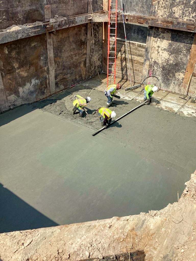
5/24/25 – Contractors for the Northpark expansion project have completed the first of two pits that will let them bore under the UnionPacific Railroad tracks. They call the first pit the “launching pit” and the second the “receiving pit.” Each pit is 40 feet long and 20 feet wide. They should start work on the receiving pit after Memorial Day.
A boring machine will be anchored in the launching pit and force 20-foot sections of 5-foot steel pipe through the dirt under the tracks toward the receiving pit. Welds between sections will take an estimated three hours each. Work will continue 24/7 until complete.
When complete, two parallel 6-foot sections of pipe will carry stormwater from west to east. Before the pits are sealed back up, contractors will place huge junction boxes in them to connect the rest of the drainage system.
Safety First
Throughout the operation, crews will aim a laser at the track surface that can detect minute movements as trains pass over.
Ralph De Leon, project manager for the Lake Houston Redevelopment Authority said, “If there is any shift, it will send a report back to the observers and they’ll be able to conduct another test 20 minutes later, half an hour later, an hour later, to see if it was just a fluctuation or if there’s really a problem inside the bore pit.”
He continued. “Every time a train goes over, work will stop anywhere from three to about 20 minutes. They will check everything all over again and then they’ll resume their work.”
Constant Checks
De Leon emphasized that, “every time they push in a piece of pipe, they take out the auger and they check the elevations and the flow lines to make sure that they’re still within the limits to get the slope they need for drainage.”
“If it looks like they’re doing nothing, it’s because they’re checking their work,” he said. The operation will continue 24/7 until complete, weather permitting.
Preparing the Pit
You can’t see into the pit from the road. But LHRA supplied these pictures of its construction. The steel frame, I-beams, and steel plates form the sides of the pit. The boring will take place where the wooden sections currently sit.
Contractors constructed a grid of steel rebar along the base of the pit. They will stand it up off the ground by placing the gray blocks at the intersections.Then they pour and spread concrete under, around and over the rebar. The red stakes indicate where they will later anchor the boring machine.Next, they spread and level the concrete.Finished bore pit. Red circles indicate where workers will anchor boring machine.Red box indicates approximate location for receiving pit.Construction of that starts next week.
A CenterPoint pole currently blocks the left bore. However, UnionPacific and CenterPoint have reached an agreement. The railroad has agreed to let CenterPoint enter its right of way and remove the pole. Until that happens, contractors will work on the right bore.
The dual bores should take approximately 4 weeks. Contractors will work under the supervision of both RailPros and UPRR inspectors until the work is completed.
New Development: Northpark Enclave
Lennar Homes of Texas is clearing land for a new subdivision called Northpark Enclave at Loop 494 and Northpark. It will contain 100 single family homes on approximately 11 acres. But one acre will go to stormwater detention. That means the homes will be built ten to an acre. That’s about as dense as the nearby Preserve at Woodridge.
Clearing for the Northpark Enclave is already underway south of Dunkin’ Donuts and Public Storage.
Looking east from over 494. Northpark Drive on left. Land for Northpark Enclave being cleared.
De Leon believes the drainage from the Enclave will go through Kings Mill into the Kingwood Diversion Ditch.
Montgomery County has not yet updated its Drainage Criteria Manual. So, it appears this development will squeak through under the old regulations developed in the 1980s which had a minor update in 2019.
Traffic Changeover Coming
The Lake Houston Redevelopment Authority posted a new 3-week lookahead schedule. In addition to work on driveways, drainage and curbs, it shows a major traffic change coming next week.
The switch is scheduled for Wednesday night, June 4th. Westbound traffic will shift to new pavement from approximately Culver’s westward to I-69. Once traffic is switched, a subcontractor will begin demolition of the old westbound lanes through that same area.
The paving crew will also continue roadway construction on westbound Northpark from the Kolache Factory to Public Storage.
Paving crew will focus on the stretch on the left.
Posted by Bob Rehak on 5/24/2025
2825 Days since Hurricane Harvey
https://i0.wp.com/reduceflooding.com/wp-content/uploads/2025/05/20250523-DJI_20250523074912_0537_D.jpg?fit=1100%2C619&ssl=16191100adminadmin2025-05-23 15:30:032025-05-24 12:23:25Northpark Update: Drainage, New Subdivision, Traffic Changeover
5/23/25 – NOAA’s National Weather Service forecasters predict an above-average 2025 Atlantic Hurricane Season with 13-19 named storms with winds of 39 mph or greater. Of those, NWS forecasts 6-10 to become hurricanes (winds of 74 mph or higher), including 3-5 major hurricanes (category 3, 4 or 5; with winds of 111 mph or higher).
NOAA believes this 2025 hurricane season forecast has a 60% probability.
In a typical Atlantic hurricane season, there are an average of 14 named storms, with 7 of those developing into hurricanes, and 3 of those becoming major hurricanes (Category 3 or higher).
Potential for higher activity from the West African Monsoon,, a primary starting point for Atlantic hurricanes.
ForMay 21, 2025. 2 – 4 degrees C above normal =- 3.5 – 7 degrees F. For current anomalies, click here.
All of these elements tend to favor tropical storm formation. The higher-heat content in the ocean provides more energy to fuel storm development, while weaker winds allow the storms to develop without disruption.
“This hurricane season also features the potential for a northward shift of the West African monsoon, producing tropical waves that seed some of the strongest and most long-lived Atlantic storms,” said NOAA.
National Weather Service Director Ken Graham said, “This outlook is a call to action: be prepared. Take proactive steps now to make a plan and gather supplies to ensure you’re ready before a storm threatens.”
Forecast Improvements
NOAA also says it will improve its forecast communications, decision support, and storm recovery efforts this season. These include:
NOAA’s National Hurricane Center will provide tropical cyclone advisories up to 72 hours before the arrival of storm surge or tropical-storm-force winds on land, giving communities more time to prepare.
NOAA’s Climate Prediction Center’s Global Tropical Hazards Outlook will provide advance notice of potential tropical cyclone risks three weeks in advance (instead of two) to provide additional preparation time.
Enhanced Communication
The National Hurricane Center will also step up its communication efforts with:
Spanish language Tropical Weather Outlooks, Public Advisories, Tropical Cyclone Discussions, Tropical Cyclone Updates and Key Messages.
An experimental version of the forecast cone graphic that includes a depiction of inland tropical storm and hurricane watches and warnings that highlights where a hurricane watch and tropical storm warning are simultaneously in effect.
A rip-current risk map that will show wells from distant hurricanes.
New Tools
NOAA also points to new tools that will provide better information. They include:
A new, experimental electronically scanning radar system called ROARS on NOAA’s P-3 hurricane hunter research aircraft. The system will scan beneath the plane to collect data on the ocean waves and the wind structure of the hurricane.
NOAA Weather Prediction Center’s experimental Probabilistic Precipitation Portal will show rain and flash flooding forecasts up to three days in advance.
2025 Names and Analog Seasons
NOAA cautions that these predictions are not a landfall forecast. NOAA will update the 2025 Atlantic seasonal outlook in early August, prior to the historical peak of the season.
In the meantime, here are the names for the 2025 hurricane season.
NOAA’s forecast is largely consistent with the forecast issued by Colorado State University (CSU) earlier this year. CSU researchers pointed to several years where the same conditions influencing the forecast were present: 1996, 1999, 2006, 2008, 2011, and 2017.
For anyone who needs a reminder, Ike struck in 2008 and Harvey struck in 2017. The season officially begins in eight days. Here is a list of links to preparedness checklists for everything from kids to seniors and pets to vehicles.
Posted by Bob Rehak on May 23, 2025
2824 Days since Hurricane Harvey
https://i0.wp.com/reduceflooding.com/wp-content/uploads/2025/05/20250522-2025-Hurricane-Outlook-PIE-Chart-Final-01.jpg?fit=1100%2C619&ssl=16191100adminadmin2025-05-22 23:07:402025-05-23 06:46:45NOAA Predicts Above-Average 2025 Atlantic Hurricane Season
5/22/25 – The Harris-Galveston Subsidence District released its 2024 Annual Groundwater Report last week. The document represents a sort of scientifically graded report card for the District.
It shows that serious subsidence problems remain in fast growing areas where regulations have yet to be fully phased in. But it also shows that subsidence has decreased dramatically where regulations have been in place the longest.
Finally, it explains what the region’s leaders are doing to get people off groundwater in those fast-growing areas. Groundwater is the major cause of subsidence or sinking of the land and can damage infrastructure such as streets, sewers, and pipelines. It can even trigger geologic faults.
Subsidence has also been linked to flooding in several ways. The effect is obvious near the coast in areas susceptible to storm surge. But it’s less intuitive farther inland at higher elevations. It has to do with creating bowls in the landscape that alter the gradient of rivers and streams. But I’ll save that discussion for a subsequent post.
Each affects the next. Let’s look at these topics briefly, then look at what the District is doing to get fast-growing areas off groundwater.
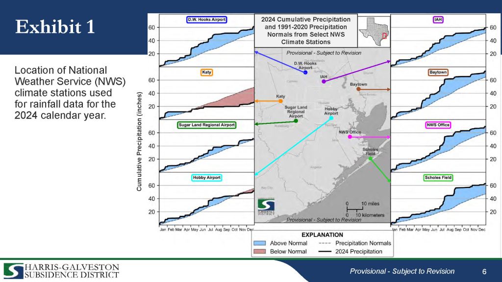
Climate Impact Negligible Last Year
Last year, precipitation was above normal for all National Weather Service reporting stations throughout the region except for Katy. Above-normal precipitation typically reduces the demand for groundwater to irrigate lawns and crops. However, irrigation usually comprises only a small percentage of total demand.
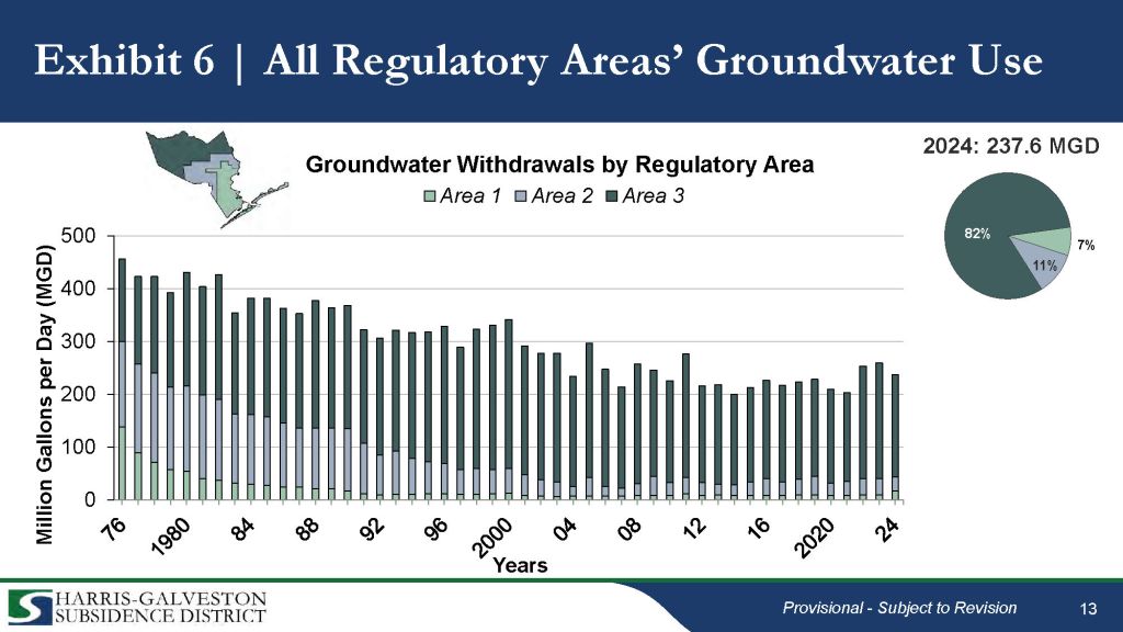
Groundwater Use Increased in Fast Growing Areas
The District monitored groundwater use in its three different regulatory areas and then averaged all three.
Regulatory Area:
#1 is closest to the coast where the District first implemented groundwater regulations 50 years ago.
#2 is farther inland. Think of Central Harris County.
#3 is the most recently regulated and the farthest inland. Regulations won’t fully phase in until 2035 there.
Here’s what happened to groundwater demand in each:
#1 showed a small uptick compared to recent years, linked primarily to industrial use.
#2 showed a drop compared to the previous two years.
#3 also showed a drop compared to the previous two years, but an increase compared to the previous 10 years. The District attributed this to rapid population growth in Area #3.
Regulatory Area #3 accounted for a whopping 82% of all groundwater used in all three areas combined.
Looking at all three areas combined, the average declined compared to the previous two years. But growth in Area #3 water demand pulled the average up compared to the previous 10 years.
The gradual phase in of groundwater restrictions in Area #3 gives new developments time to migrate to water from alternative sources.
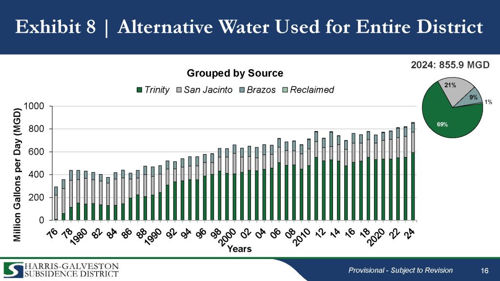
Groundwater Usage Decreasing as Alternative Water Usage Increases
The District defines “alternative sources” as anything other than groundwater. It usually refers to surface water from various sources such as the Trinity, San Jacinto or Brazos Rivers.
Overall, the use of alternative water is growing and reached a new high last year. Conversely, groundwater use declined despite growth in total water demand.
But growth in surface water supplies met that demand and then some.
Growth in surface water
All things considered, that’s good news.
Impact on Groundwater Levels
Restricting groundwater use reduces subsidence. To see its impact, the District measured increases and decreases in water well levels. The District can provide comparisons of hundreds of well levels today with the previous year, five years and 48 years. Predictably, the highest decreases clustered within the fastest growing areas to the north and west.
But well levels also actually rose in some areas. Where that happened, aquifers are recharging faster than they are depleting – another good sign that the regulatory regime is working.
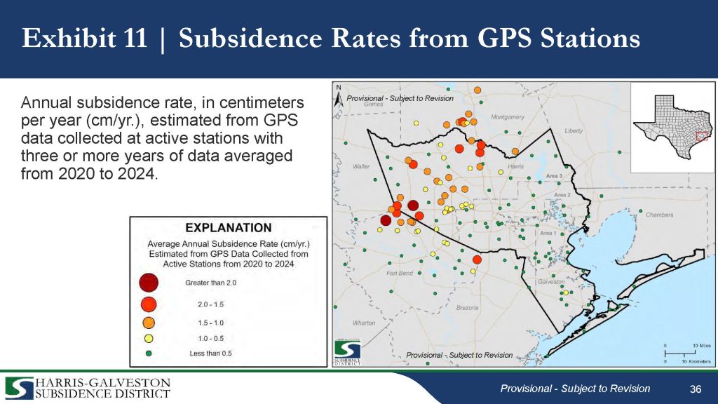
Impact on Subsidence
The Subsidence District maintains an extensive network of GPS stations that monitor subsidence across 12 counties.
Two things stood out:
The fast-growing Area #3 subsided much faster than the other areas that already reduced their use of groundwater.
Katy showed the greatest subsidence. It received the least rain and is also among the fastest growing areas in the region.
Filling Observational Gaps Between Wells
The District also used “interferograms” to render high-resolution subsidence maps. Radio waves bounced off earth form the basis for interferograms. By measuring the timing of return signals as the satellite circles the globe endlessly, and comparing the differences, the technique can achieve an accuracy of millimeters.
Interferograms produced by the Subsidence District clearly show bands of subsidence that correspond to the length of time regulations have been in effect.
But there’s even better hope for the future.
Projects Enabling Groundwater Conversion
Area leaders have collaborated on four large projects to move people off groundwater.
Northeast Transmission Line Project, which will pipe treated surface water from Lake Houston into central and northern Harris County. (Purple line below.)
Surface Water Supply Project which will take water from the new plant to western Harris and northeastern Fort Bend Counties. (Orange Line Below)
In addition, the City and several water authorities are working on their own local distribution systems to move water to customers.
It’s comforting to see people of the region coming together to provide for the security of the next generation.
5/20/25 – Yesterday, I posted about a doom loop and virtuous cycle as they related to flooding in general. Doom Loop Part II will focus on more specific patterns that I have seen repeated in the Houston area over time.
“Doom loop” is often used in public policy debates to describe a series of events that contribute to a downward spiral, such as increased flood risk for more people.
The words and slides below are taken from a presentation delivered to the Harris County Community Resilience Flood Task Force and Infrastructure Resilience Team today. I hope they stimulate a discussion. Only through correct diagnosis of the problem can we ever hope to find a solution.
To download a copy of the presentation, click here. To review the narrative that goes with the slides, see below.
Slide One: A 75-Year Perspective
What happened in fast-growing watersheds inside Beltway 8 decades ago is now happening in fast growing watersheds outside the Beltway today. We’ve had multiple waves of expansion in the last 75 years. And we keep repeating the same mistakes.
Remember this slide. We will come back to it at the end. It shows base flood elevation – the estimated depth of a 100-year or 1% annual chance flood above ground level.
Slide 2: Doom Loop
A doom loop is the opposite of a virtuous cycle. For instance, crime increases. So people move away and tax revenue decreases. That means less money for police, crime continues to increase, etc. In flooding, in north Houston, the doom loop looks something like this.
These six things build on each other to compound risk. Let’s look at each and some real world examples inside and outside of the Beltway.
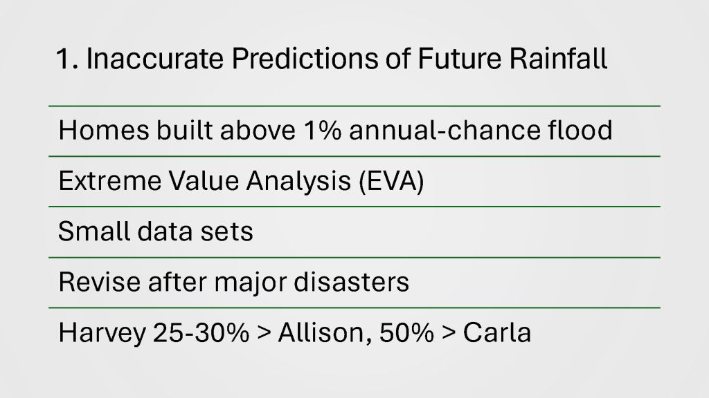
Slide 3: Inaccurate Predictions
All of our homes and infrastructure are built around estimates of future rainfall. But those estimates are a shifting target.
The estimates form the foundation of our building codes and development regulations.
Statisticians base them on a branch of mathematics called extreme value analysis (EVA). EVA tries to estimate the probability of unknown future events based on the frequency of extremely rare past events.
But because past superstorms are rare, the statisticians do not have much data to work with. So, they must revise their estimates every time we have a major new disaster such as Carla, Allison or Harvey.
Today, Houston and Harris County design infrastructure around rainfall estimates that are 50% greater than the those in place when most of Houston’s streets, homes and drainage systems were built.
Slide 4: Major Iterations of Stats
Since I moved to Houston 42 years ago, we’ve had three different standards.
Design depth listed in inches on right,
The standard developed after Carla in 1961 predicted a 1% annual chance storm would drop 12 inches of rain in 24 hours.
But since Harvey, we now think of such a storm as one that drops 18 inches in 24 hours.
That’s 50% more than the standard that shaped much of the infrastructure Houston put in place before Allison.
But adoption of these standards is not uniform. Nor is adoption fast. Some places in the region still use TP-40 estimates developed 64 years ago.
Slide 5: Infrastructure Changes with Expected Rainfall
What depends on these statistics? Lots.
Atlas 14 rainfall statistics for north Houston(right) now determine the design capacity of new infrastructure in some parts of the region.
In short, the rainfall design standards form the basis of everything that determines whether you will flood in the next superstorm.
However, they aren’t uniformly adopted throughout the region. Potential homebuyers should look upstream in surrounding jurisdictions to see whether those areas are basing their development decisions on standards that are this strict.
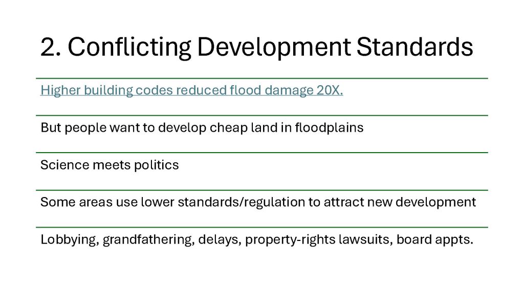
Slide 6: Conflicting Standards Sometimes Fight Each Other
Building codes and development regulations based on those rainfall design standards also get updated periodically. But never at the same time.
After Harvey, the county examined how all the homes built after 2008 fared during the storm. They were damaged at ONE TWENTIETH the rate of homes built before 2008.
So why didn’t all the surrounding jurisdictions immediately update their development standards and building codes?
This is where science meets politics.
Some areas use lower standards/regulations as a way to attract new development.
And some (certainly not all) developers manage to find reasons why they should be allowed to develop cheap land in floodplains.
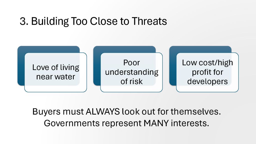
People love living near water. They pay a premium for it.
But humans usually have a poor understanding of risk. That means low cost and high profit for developers. They can buy up cheap floodplain land and sell it for a premium.
Buyers must always look out for themselves. Governments represent many interests – sometimes conflicting. They represent developers just like they represent you.
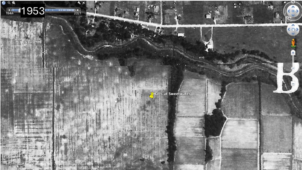
Slide 8: The Halls Bayou Example
This slide shows Halls Bayou at what would later become Sweetwater Lane in 1953. It was all farmland.
In the 1960s, the farmer sold the land to a developer.
Slide 9: Land Built Out Before FEMA
Here’s what it looked like by 1978, a year before FEMA was formed.
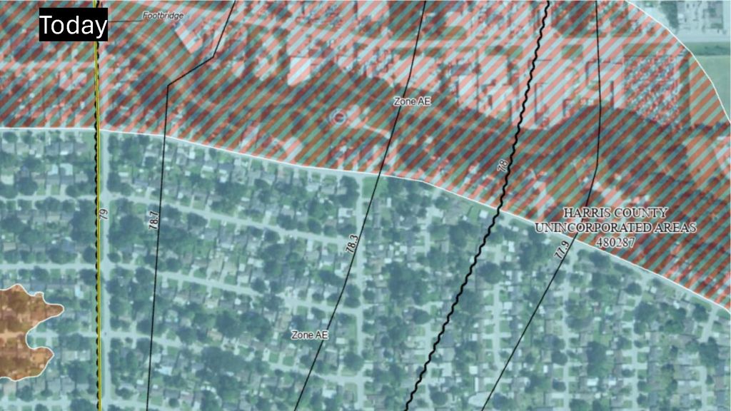
Slide 10: Flood Risk Today
And here’s what the flood risk looks like today…now that we have FEMA and mapped floodplains.
That crosshatched area is floodway. The rest is floodplains.
Slide 11: Halls Bayou Mid-reach Segment
Here’s a wider shot of Halls today. The development is so dense, it’s hard to see the bayou. So I outlined it in red.
That’s 59 angling up toward the right. Talk about density!
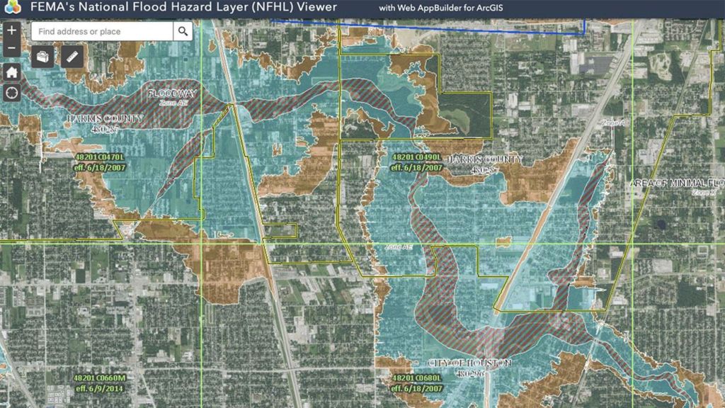
Slide 12: Halls Flood Risk Before Latest Updates
And here are the floodways and floodplains as FEMA mapped them in 2014. FEMA has not yet updated the floodplains using Hurricane Harvey data.
Keep in mind that these could expand 50% – 100% with MAAPnext.
Slide 13: How Upstream Development Can Undermine Downstream Safety Margins
Other watersheds, such as the San Jacinto still have a lot of undeveloped area upstream. For instance, the San Jacinto watershed north of Lake Houston is 50% larger than Harris County itself and rapidly developing.
But some jurisdictions, such as Montgomery County have not seriously updated their drainage regulations since the 1980s. So much of the new development is insufficiently mitigated.
That’s why – downstream – we get 100-year floods on 10-year rains, like we did last May. There are lots of loopholes that developers can use to game the system.
I found one that mischaracterized soil surveys to exaggerate the rate of infiltration. That allowed him to get away with building 12,000 acres in wetlands with less than 10 acres of detention basins.
Another way to get away with building less detention than you should is with hydrologic timing studies. Let’s look at those.
Slide 14: Beat the Peak
The state water code stipulates that developments can have “NO ADVERSE IMPACT’ on downstream neighbors. To prove that, engineers compare pre- and post-development runoff rates. If the post-rate is no higher than the pre-, then they can claim no adverse impact.
You can see that in the two smaller curves below on the right. They illustrate a pre/post comparison where timing surveys are prohibited.
But some jurisdictions still allow timing studies, also known as beat the peak studies or flood routing studies.
The theory is that if you can get your runoff to the river fast enough, you aren’t adding to the peak of the flood. So, you shouldn’t be forced to build detention basins. But sometimes the data they use is very old, i.e., from the 1980s in the case of Montgomery County. And it ignores the cumulative effect of development since then. MoCo, by the way, is the seventh fastest growing county in America.
But there’s another problem, too. What happens when an area sends its storm water downstream from one direction as a storm like Harvey approaches from the other?
People in the middle get squeezed. Badly. That’s the runoff curve on the left above that assumed stormwater from development would be long gone by then.
If each development took care of its own runoff, we wouldn’t have this problem. We would have to worry about the uncertainty. That’s why eliminating such studies was one of Harris County’s five main recommendations to surrounding governments after Harvey.
Slide 15: Difficulty of Adapting Downstream
Downstream, it’s difficult to adapt to insufficiently mitigated upstream development.
Everything is already built out. You can’t rip up every street in the county to increase the size of storm sewers. You can’t elevate every home in the City of Houston. And you can’t always expand drainage channels because there’s often no room.
That makes change expensive, disruptive and often politically unpalatable. And it puts political leaders in a “double bind” – a “damned if you do/damned if you don’t” situation. Many families would rather live with periodic flooding if FEMA continues to insure against it – as long as they don’t have to move. Sometimes, there’s just no way to win.
Do you think if leaders had known what they were going to be up against years ago, they would have allowed building this close to the bayou?
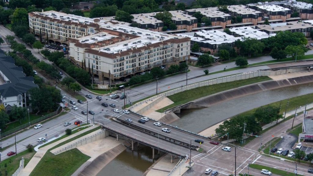
Slide 17: An Even Closer Shave
This apartment complex, also on Brays, is so close, it looks like it could slide in.
Slide 18: Flood-Mitigation Funding
Now consider all those problems against another one: our historical unwillingness to fund flood mitigation at meaningful levels.
Before the flood bond, HCFCD had only $60 million per year for capital improvement projects. Sometimes the district had to save up for years to build one detention basin.
After Harvey, fixing flooding was the #1 priority in the region and the state. We passed the flood bond and launched a statewide flood-planning process.
But with time and distance, people lose their sense of urgency. They want to move on. So, eight years later, we have a state flood plan with $54 billion worth of projects. And $1 billion to address them. And don’t expect the feds to bail us out any time soon. FEMA and HUD are both facing unprecedented uncertainty in Washington.
Slide 19: Step and Repeat
I hope you have seen how this doom loop repeats itself as Houston expands ever outward.
Remember that house under 25 feet of water in the opening slide. It’s located at the bottom of this area outlined in red where four streams come together about a block west of 59 and Kingwood.
A foreign developer wants to build 7,000 homes in that blue area which represents floodplains.
One hydrologist told me that building that project would be like aiming a fire hose at Kingwood.
Slide 20: Other Examples
But that’s not the only example.
Remember that development that falsified the soil tests to avoid building detention. That’s Colony Ridge, upstream on the East Fork in Liberty County. They built an area 50% larger than Manhattan over wetlands which are nature’s detention basins.
The Commons of Lake Houston fought Houston Public Works for seven years all the way to the Texas Supreme Court for the right to build 500 homes in the swampy floodplain next to the East Fork. I have pictures of it under 17 feet of water.
And Romerica tried to build 50-story high-rises with underground parking in what will soon become the FLOODWAY of the San Jacinto West Fork.
And that’s why Texas has more people living in floodplains than the entire populations of 30 states. Most of them here in Harris County.
Posted by Bob Rehak on 5/20/25
2821 Days since Hurricane Harvey
The thoughts expressed in this post represent opinions on matters of public concern and safety. They are protected by the First Amendment of the US Constitution and the Anti-SLAPP Statute of the Great State of Texas.
https://i0.wp.com/reduceflooding.com/wp-content/uploads/2025/05/Why-Do-We-Flood-Rev3_Page_01.jpg?fit=2000%2C1125&ssl=111252000adminadmin2025-05-20 22:14:512025-05-21 09:46:26Why We Flood: Doom Loop, Part II
5/19/25 – In public-policy discussions, doom loops are self-reinforcing negative events or policies that lead to a downward spiral. Example: High crime rates force residents to move to safer neighborhoods. Then property values decline. The police get less money to patrol. And that leads to more crime. The area spirals downward.
Negative vs. Positive Cycles
A virtuous cycle is the opposite. It is a self-reinforcing, positive, upward spiral. Lower crime, for example, attracts population which provides the funding to keep the area even safer and growing.
You can see a doom loop in flooding if you look back far enough. Tomorrow, I will give a presentation to the Harris County Community Flood Resilience Task Force that looks back 75 years at how Houston’s growth has affected flooding.
How We Handle Growth Is Root Issue
Unfortunately, growth is not always positive from a flooding perspective. If not managed properly, it can create a doom loop that increases flooding. The presentation focuses on how we repeat the mistakes of the past instead of reversing that downward spiral.
The table below from ChatGPT shows a generalized Flooding Doom Loop and a Flood-Resilience Virtuous Cycle for Houston.
Flooding Doom Loop
Flood-Resilience Virtuous Cycle
Rapid, unzoned development in floodplains
Stronger land use and drainage regulations
Loss of natural absorption (wetlands, prairies)
Preservation/restoration of natural systems
Increased stormwater runoff
Reduced runoff and slower flow
Overloaded drainage systems and bayous
Improved drainage capacity
Recurring flood damage
Fewer flooded properties
Disinvestment and property value decline
Higher property values and stability
Underfunded flood mitigation projects
Increased public/political support
Continued risky development
Sustainable development patterns
Add More Layers of Complexity and Depth
Now superimpose rapid population growth in ever-expanding, outward, concentric circles. That adds a new layer of complexity that my presentation explores with specific examples. It shows how areas outside Beltway 8 are fighting the same battles that areas inside the Beltway fought decades ago.
Conflicting Development Standards Across Jurisdictions
I examine, for instance:
Conflicting development standards across jurisdictions
And our suburbs are some of the fastest growing smaller cities, too. For many years recently, Conroe was the fastest growing city in America. And new census data shows that Fulshear (near Katy) is now the second fastest growing city percentage wise.
As the metropolis sprawls, developers can exploit differences in regulations between cities and counties to increase their profit margins. My presentation shows several examples.
Check back tomorrow for Doom Loop Part II.
Posted by Bob Rehak on 5/19/25
2820 Days since Hurricane Harvey
https://i0.wp.com/reduceflooding.com/wp-content/uploads/2025/05/Flooding-Doom-Loop.jpg?fit=1100%2C561&ssl=15611100adminadmin2025-05-19 15:53:272025-05-19 16:12:26Doom Loops and Virtuous Cycles in Flooding