5/19/26 – Contractors working on the Woodridge Village-Taylor Gully Project finally appeared yesterday and started working today. Construction on the site had been paused since November, 2023.
That’s when Harris County Flood Control District (HCFCD) cancelled an Excavation and Removal Contract with Sprint Sand & Clay to apply for a Community Development Block Grant (CDBG) from the Texas General Land Office and US Department of Housing and Urban Development.
This particular CDBG project falls in the Mitigation Category. That means, HCFCD and the contractors have until March 31, 2028 to finish it – about a year and ten months.
History of Project
All this comes seven years after Perry Homes cleared approximately 270 acres on its Woodridge Village property, and sloped the land toward Taylor Gully … without building the required detention basins. Then the flooding problems started. Taylor Gully flooded up to 600 homes twice in 2019, once on May 7 and once in September during Tropical Storm Imelda.
Harris County and City of Houston bought the property from Perry Homes in 2020. That let Sprint Sand & Clay start excavating a giant detention basin on Woodridge. They removed 156,478 cubic yards of sediment. That brought the total detention on the site up to Atlas-14 requirements, But per HUD requirements, HCFCD had to stop Sprint while it applied for a grant, which Congressman Dan Crenshaw helped secure.
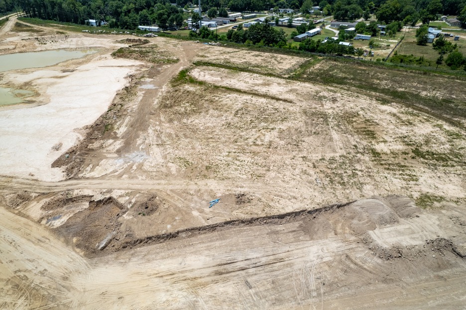
However, work stopped before the basin was finished and it was never connected to the rest of the drainage on the site. See below.
Woodridge Village in November 2023 when E&R contract ended. Note storm sewer pipe scattered around excavation.
Sprint removed all that dirt for less than a thousand dollars. The picture above shows how the site looked the day Sprint left. They gave the current contractors a giant head start.
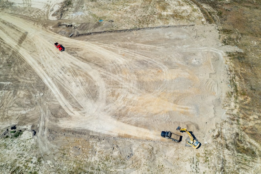
Site Clean Up Started Today
Today, after a hiatus of almost three years, a new contractor started by cleaning up the site. I photographed them breaking up the old storm sewer pipe unearthed by Sprint.
Woodridge Village on 5/19/2026. Note contractors breaking up storm sewers that Perry had installed near detention basin excavation.
I counted three pieces of construction equipment onsite today: a small bulldozer, an excavator that was breaking up the pipe. And a forklift that ferried pipe to the excavator.
Restart of construction on 5/19/2026
I didn’t see any other equipment on Woodridge or along Taylor Gully.
Looking upstream along Taylor Gully from West Lake Houston Parkway toward Rustic Elms and Woodridge.Looking downstream toward the end of Taylor Gully.
What Project Includes
On 10/6/25, the Texas General Land Office (GLO) approved approximately $42 million to construct Taylor Gully Channel Conveyance Improvements and a Woodridge Stormwater Detention Basin.
On 3/26/26, the county purchasing agent approved a $29,387,654 bid from Brice Construction & Design, LLC to finish constructing the Woodridge and Taylor Gully flood mitigation projects in Kingwood
The Woodridge portion of the project (above the county line) includes 421.6 acre feet of additional stormwater detention capacity (See Compartment 1 above).
Other planned improvements along Taylor Gully include:
13,118 feet of channel conveyance improvements
Placing a concrete channel along the base of it
Replacing the concrete culverts at Rustling Elms with an open-span bridge.
Altogether the plan should reduce the water surface elevation by up to 5 feet and help 24,000 thousand people who live near or commute through the area.
https://i0.wp.com/reduceflooding.com/wp-content/uploads/2026/05/DJI_20260519142939_0131_D.jpg?fit=1100%2C619&ssl=16191100adminadmin2026-05-19 17:37:092026-06-13 12:29:05Woodridge-Taylor Gully Construction Starts Again
1/28/26 – People living near the Kingwood Diversion Ditch and the Woodridge Village/Taylor Gully area have been asking what happened to their flood-mitigation projects. Good news: Both are moving forward. Here’s some historical context, where the projects currently stand, and what comes next.
Kingwood Diversion Ditch
The Kingwood Diversion Ditch splits off Bens Branch between Northpark Drive and the new St. Martha Catholic Church. It runs down the western side of North and South Woodland Hills past the fire station on Kingwood Drive. Then it continues south past Trailwood, Deer Ridge Park and finally joins the San Jacinto West Fork at River Grove Park. Along the way, it goes under four bridges.
Neel-Schaffer completed a preliminary engineering study in early 2025. The company recommended widening the Diversion Ditch and building a new outfall to West Fork west of River Grove Park. They projected the cost to be almost $41 million, but it would reduce the floodplain size by 177 acres and remove 34 structures from the floodplain.
Diversion Ditch shown in white, proposed new outfall in green, and Bens Branch in red.
The improvements would divert enough stormwater from Bens Branch to take it from a 2-year level of service to a 100-year level. That’s good news for the merchants in Kingwood Town Center. They all flooded during Harvey and 12 seniors died at Kingwood Village Estates.
The project almost died last year when Democratic County Commissioners voted to redeploy all remaining flood bond funds to the highest scoring projects on their equity prioritization framework. However, they later reconsidered that motion. The Diversion Ditch already had federal partnership funds allocated to it thanks to the work of Congressman Dan Crenshaw. His earmark for the Walnut Lane Bridge saved it from the chopping block.
Now the project is moving again. In late 2025, Harris County awarded a contract to Halff Associates, Inc. for the final engineering and design of the project.
In its January 22 board meeting, the Texas Water Development Board authorized an agreement with Harris County Flood Control District for a $5 million grant that State Representative Charles Cunningham obtained during the 89th Legislative Regular Session. (See item 12.)
HCFCD spokesperson Emily Woodell said the District expects the design work to start by March 1. She also says that additional funding will come from EPA grants to cover design and the 2018 bond to cover construction. Woodell expects construction to begin in late 2027.
Woodridge Village/Taylor Gully
The Kingwood Area Drainage Analysis ranked the Diversion Ditch and the Woodridge Village/Taylor Gully Project as the two most important projects in Kingwood because they help the largest numbers of people.
The 270-acre Woodridge Village Project is the aborted Perry Homes development purchased by Harris County and the City of Houston in 2020. It lies north of Sherwood Trails and Elm Grove in Montgomery County. Except for a few acres on the extreme western end, virtually all of it drains into Taylor Gully.
Perry’s contractors clearcut the Woodridge site starting in 2017 and sloped it toward Taylor Gully. Then before they installed detention ponds and drainage systems, runoff from the site flooded up to 600 homes twice in 2019. Residents had not even finished repairing their homes from the first flood in May, when they flooded again in September. A massive class action lawsuit resulted in a substantial settlement for the victims.
Taylor Gully flooding near Rustling Elms on May 7, 2019.
Before purchasing Woodridge Village from Perry, HCFCD stipulated that they had to finish building all of the stormwater detention basins planned as part of the buildout. However, those detention basins only brought the property up to pre-Atlas 14 standards. They fell 40% short of Atlas 14 requirements.
Shortly after the purchase, HCFCD started building an additional detention basin to bring the total detention capacity onsite up to and beyond Atlas-14 requirements. Sprint Sand and Clay began the work under an excavation and removal (E&R) contract. E&R contracts give HCFCD a head start on production. They let contractors begin removing dirt for a nominal fee and then sell it on the open market to make up their profit margin.
Woodridge Village on May 31 2025. The beginning of a new detention basin was never completed or connected.
However, when HCFCD applied for a HUD CDBG-MIT grant through the Texas General Land Office, HCFCD was forced to pause the project. That’s because projects cannot change while the GLO and HUD consider a grant request.
Scope of project outlined in preliminary engineering review. Compartment 1 is in current bid and will take project up to and slightly beyond Atlas 14 requirements. Compartment 2 will be treated as a separate project in the future if/when needed.
Expand a portion of Taylor Gully and line it with concrete.
Build another stormwater detention basin on Woodridge Village holding 412 acre-feet.
Replace the culverts at Rustling Elms with a clear-span bridge.
Fast forward: GLO and HUD approved grants for $42 million in October, 2025. HCFCD put the project out for bids. And proposals are due by Feb. 16, 2026. See screen capture from County purchasing below.
Screen capture supplied by Precinct 3 Engineer Eric Heppen
Even though the bid above is listed as “channel conveyance improvements,” according to Woodell, it also includes the Woodridge Village Stormwater Detention Basin(s). “Since Woodridge mitigates Taylor Gully, those two projects have been combined forever after,” she said.
The HUD/GLO deadline for finishing the project is March 31, 2028. That’s do-able if everyone hustles.
Additional funding for this project came from U.S. Representative Dan Crenshaw. He secured federal funding for Taylor Gully improvements in March 2022. And Representative Charles Cunningham helped secure state funding through the TWDB.
At a September 2024 press conference where Woodridge meets Taylor Gully. Left to Right, Harris County Precinct 3 Commissioner Tom Ramsey PE, US Rep. Dan Crenshaw, HCFCD Exec. Dir. Dr. Tina Petersen, Houston City Council Member Fred Flickinger and State Rep. Charles Cunningham.
More news to follow when we see the bids.
Posted by Bob Rehak on January 28, 2026
3074 Days since Hurricane Harvey
https://i0.wp.com/reduceflooding.com/wp-content/uploads/2026/01/Kingwood-Flood-Mit.jpg?fit=1100%2C670&ssl=16701100adminadmin2026-01-28 14:44:172026-01-28 17:05:33Update on Two Kingwood Flood-Mitigation Projects
Said another way, more than 100,000 homes flooded because building codes did not recognize the need to build to higher standards.
Accordingly, in the wake of Harvey, Harris County, Houston and many surrounding areas increased building code requirements. Now, most jurisdictions require that the minimum finished floor elevation be established at (or waterproofed to) the 500-year flood elevation “shown on the effective flood insurance study.”
But as builders started elevating foundations with dirt they excavated from stormwater detention basins, water started running downhill. And not always toward the detention basins. Sometimes it flows toward pre-existing neighboring homes built at lower elevations.
The problem can most often be seen during construction after forests are cleared next to existing subdivisions.
I was driving north on the US59 feeder the other day and saw this near E. Wallis Drive in Porter.
New development has been built up almost to the roofline of adjoining homes.
And less any doubt exists about how the contractors sloped the built-up area, note the erosion on that hillside in the photo below.
Note water ponding in yard and along fence line of corner home.
Also note the amount of sediment washed out to the feeder road and running into the storm drain. Contractor has installed no silt fences as best practices dictate.
As I was developing a post about the new development above, I received an email from Eric Unger who lives next to another new development several blocks south. He said that contractor raised the ground level at least a foot relative to his and his neighbors’ yards, “which results in their entire acreage now sitting higher than our yards.”
Then he said, “A recent 2-inch rain fall caused a flow of silty water to invade our yard and come dangerously close to our back porch.” He sent this image taken more than day later to me.
Photo courtesy of Eric Unger
Erosion and ponding water in the photo below make it easier to see the slope of the land toward his and his neighbors’ homes.
Note ponding next to fence lineof Unger home (bottom left) and erosion next to road.
Flooded homeowners pursued a class action lawsuit that was ultimately settled in the homeowners’ favor.
During discovery, it became apparent that contractors had shaved down a berm protecting Elm Grove and that they had not followed the engineering plans. Specifically, they were supposed to install stormwater detention basins in one section before clearcutting the next. See below what that policy resulted in.
Car submerged during Imelda at the end of Village Springs adjacent to Woodridge Village. Note the sediment laden water from the development. Photo courtesy of Allyssa Harris.
In Huffman, a developer clearcut 533 acres uphill from Northwoods Country Estates right before they got 17 inches of rain.
Friendswood’sSila Development in Huffman flooding neighbors in 2024
During eight years of blogging about flooding, I’ve seen this problem repeatedly.
Chapter 11.086 of the Texas Water Code prohibits altering drainage in ways that flood neighbors. But it tells developers what they should not do, not what they should do.
In my opinion, developers should force contractors to build berms shielding neighbors as soon as clearing is complete. They should also build detention basins as soon as possible after clearing. Instead, many wait a year or more.
Silt fences are not enough…as you can clearly see in the photo above.
I don’t wish to tar all developers and contractors. Many are both reputable and responsible.
But as we try to avoid problems in the future, we also need to define practices that protect homes built in the past.
Posted by Bob Rehak on 12/1/25
3016 Days since Hurricane Harvey
The thoughts expressed in this post represent opinions on matters of public concern and safety. They are protected by the First Amendment of the US Constitution and the Anti-SLAPP Statute of the Great State of Texas.
https://i0.wp.com/reduceflooding.com/wp-content/uploads/2025/12/20251126-DJI_20251126151404_0475_D.jpg?fit=1100%2C619&ssl=16191100adminadmin2025-12-01 20:17:582025-12-02 12:09:59How Solving Problems of the Past Can Create Problems of the Future
3/10/25 – In the last week, Harris County Flood Control District (HCFCD) launched a new interactive map at the bottom of its homepage. In it, HCFCD calls many projects complete that have not even started.
The map supposedly contains the status of each project in the county along with links to more project details.
However, the information is riddled with errors. The map also contains several usability issues that place barriers between people and information.
Together, the issues show a disturbing lack of attention to detail and quality control that undermines the credibility of HCFCD.
Examples of Incorrectly Coded Projects
For instance, you may be pleased to know that the project to add more floodgates to the Lake Houston Dam is “complete.” It’s not. Ask Houston City Council Member Fred Flickinger who just provided an update on the ongoing engineering of the gates.
This and all other screen captures below taken on 3/10/25. Note project status in lower right corner.
Neither are the projects complete to add stormwater-detention capacity to Woodridge Village and to improve Taylor Gully. However, the map shows them completed also.
HCFCD also marked the Kingwood Diversion Ditch Project “in progress.” It’s not.
“None of this information is true!”
– Bob Rehak
With the exception of the Woodridge project, the District has not turned one shovel of dirt on any of the projects above.
The District tabled the Woodridge project in November 2023 when it decided to seek HUD funding to complete it. Here’s how HCFCD left the site.
“Completed” Woodridge Village Detention Basin. Photo taken today, 3/10/25.
HCFCD even marked the TC Jester Detention Basins on Cypress Creek complete.
HCFCD did not respond to questions about the errors, nor did it take the error-ridden, interactive map down as of close of business today.
Usability Flaws, Too
In addition to the project-status errors, the map also contains some serious usability flaws.
For instance, clicking on the link for more information about a project sometimes takes one to a page that asks you to sign into “ArcGIS Online.”
But that requires HCFCD employee credentials.
However, take heart. If you wait several minutes, information may eventually load OFFSCREEN and ABOVE the sign-in prompt…where few would ever bother to look for it. Very clever!
A source familiar with Harris County Universal Services, the county’s IT department, attributed the bizarre performance of the map, in part, to incompetent coders and project managers with forged credentials working on H1-B visas.
That may be an even bigger problem! If you think Elon Musk rummaging through IRS data is an issue, imagine foreign nationals rummaging through your Harris County tax information. But I digress.
In the meeting, Commissioners adopted several measures to limit the financial impact to the county in case DOGE rescinds $1.1 billion of previously promised HUD disaster-relief and flood-mitigation funding.
In the same meeting, Commissioners also demanded an update from HCFCD Executive Director Tina Petersen about the status of every project. The reason: so they could make sure so-called “equity projects” were completed in low-to-moderate income areas before those in more affluent areas.
Precinct 1 Commissioner Rodney Ellis said he didn’t want to wait “until all the money was gone.” He added, “I know there’s not enough money to do all the projects we talked about and everybody else knows it.”
I hope Ms. Petersen provides better information to her bosses than to the public. She just received a $90,000 raise. You could hire several proofreaders for that!
No telling how many errors are embedded in the interactive HCFCD map; I am not familiar with every project in the county. If you know of other errors in projects near you, please send me a note through the contact form on this website.
Posted Bob Rehak on 3/10/25
2750 Days since Hurricane Harvey
The thoughts expressed in this post represent opinions on matters of public concern and safety. They are protected by the First Amendment of the US Constitution and the Anti-SLAPP Statute of the Great State of Texas.
https://i0.wp.com/reduceflooding.com/wp-content/uploads/2025/03/20230812-RJR_2246.jpg?fit=1100%2C733&ssl=17331100adminadmin2025-03-10 20:29:092025-03-10 23:38:55HCFCD Calls Projects Complete that Have Not Even Started
1/16/2025 – Harris County Precinct 3 Commissioner Tom Ramsey, PE, and Distict E Houston City Council Member Fred Flickinger discussed the status of numerous flood projects at a meeting of the Kingwood Area Republican Women today at the Oakhurst Golf Club.
Ramsey addressing Kingwood Area Republican Women’s Club today.
Among the projects they covered were:
Taylor Gully Improvements/Woodridge Village Detention
Legal Changes Governing Pre-Release of Water from Lakes
Edgewater Park
Dredging
Medians
Flood Tunnels
Subsidence
Below are the highlights. They also discussed other issues such as median maintenance, vine control, crime, taxes, government waste, elections and more. But I will focus primarily on infrastructure issues related to flooding – especially Taylor Gully and Woodridge Village, because of pending approvals this month.
Taylor Gully/Woodridge Village
After Perry Homes clearcut approximately 270 acres in Montgomery County, hundreds of Kingwood homes flooded twice in 2019 along Taylor Gully. Taylor Gully runs through the northern part of Kingwood from Kingwood Park High School to White Oak Creek.
Harris County Flood Control District (HCDFC) began working on mitigation plans in 2021 and presented preliminary recommendations to the community in December, 2022.
The county had high hopes for funding from the Texas General Land Office (GLO) and U.S. Department of Housing and Urban Development (HUD), but those ran into a potential snag. Taylor Gully improvements fit within available HUD funding, but Woodridge Village (the former Perry Homes Property) did not. HCFCD hoped to build more stormwater detention basin capacity on Woodridge to help control Taylor Gully expenses downstream.
Regardless HCFCD pressed forward. They combined the two projects. And according to HCFCD, both now fit with available funding capacity (see “above the line” list on page 2) of the list being presented to Commissioners Court next week on 1/23/25.
The county purchased Woodridge Village in February 2021. Shortly thereafter, HCFCD began an excavation and removal (E&R) contract to get a “head start” on the basins. Indeed, the head start brought the total stormwater detention on the site almost to Atlas-14 standards.
However, HCFCD was forced to terminate the E&R contract before the basins could be completed. That was to comply with HUD requirements while HUD considered the grant application.
This is potentially great news for the people who live in Sherwood Trails, Elm Grove, Mills Branch and Woodstream.
Watch commissioner’s court closely next Thursday. The Kingwood area drainage study named this project as one of the two most important in Kingwood.
Kingwood Diversion Ditch and Upstream Detention
The Kingwood Diversion Ditch was the other of the two most important projects. The Diversion Ditch takes floodwaters out of Bens Branch, which runs diagonally through the center of Kingwood from St. Martha Catholic Church to River Grove Park.
Improving the Diversion Ditch would reduce flood risk for hundreds of homes and apartments, Kingwood High School, Town Center, and Kings Harbor. Both Bens Branch and the Diversion Ditch currently have a two-year level of service. That means they have a 50% chance of coming out of their banks in any given year.
Ramsey estimated today that the project could cost $60 million. However, he also indicated that U.S. Congressman Dan Crenshaw “got us enough money so we can do the final engineering.”
Eric Heppen, Precinct 3 engineer, later stated that once Commissioners Court approves the preliminary report, it will be made public.
Flickinger emphasized that he is talking with Montgomery County, trying to get them to retain more of their floodwaters. He raised concerns about a new 200,000 sq. ft. convention center planned for US59 at Valley Ranch. “That will generate a lot of runoff that could come down to us, unless we work together to find a way to hold that water up there.”
Houston City Council Member Fred Flickingerat same meeting.
Additional Floodgates for Lake Houston
Shortly after Harvey, many people pinned their flood-mitigation hopes on additional floodgates for the Lake Houston dam. The idea: to lower the lake faster when it becomes certain that a storm will flood the area. The existing gates have 1/15th the capacity of Lake Conroe’s. So Lake Houston must start releasing far earlier in advance of storms than Lake Conroe. And by the time Lake Houston is lowered, storms can veer away, wasting valuable water.
So Conroe tends to hold its water back until it is absolutely certain. At that point, it has no other choice than to release water at high rates that flood people downstream.
Being able to lower Lake Houston faster would let Lake Conroe release earlier and slower, smoothing out flood peaks downstream.
Ramsey estimated the cost of 11 new floodgates that could release 80,000 cubic feet per second at $150 million. He said the final engineering should be completed this year. He also said that bidding and construction could start in 2026.
Legal Changes Governing Pre-Release of Water
Flickinger addressed a related legal issue. State law limits the release of water from lakes; it must be only for defined beneficial uses and flood control is not one of them.
So, Flickinger is working with State Rep. Charles Cunningham to change that and increase the limit. “Bottom line,” he said, “is that we need to release more water sooner rather than holding it back until we’re adding to the crest of the flood.”
Flickinger is also working with the San Jacinto River Authority on these changes.
Edgewater Park
After Harvey, the County acquired land on the northeast corner of the West Fork and US59, which will turn into Edgewater Park. It will also connect the Houston Parks Board’s West Fork Greenway with the Spring Creek Nature Trail. Ramsey said the plans will be made public very soon. After the meeting, Precinct 3 engineer Eric Heppen confirmed the plans were 99% complete.
Ramsey said, “Soon, you’ll be able to go from Kingwood to Tomball and not cross a road.” That should be a tremendous draw for hikers and bikers and the entire area.
Dredging
Flickinger discussed two aspects of dredging not covered in last night’s post. First, he is seeking additional funding to continue the current program while the dredge is on the lake. Second, he feels opportunities exist to increase efficiency.
I asked what he meant by that. FEMA restrictions on the funds currently being used limit the dredging to “pre-Harvey” conditions. That means, Callan Marine, the contractor, must dredge to different depths to match the exact bottom profile that existed before Harvey. And that requires repositioning the dredge more than if you were just dredging to a uniform depth across wide areas.
The search for additional funding has led Flickinger to the City, the Coastal Water Authority (CWA) and former State Representative Dan Huberty. Huberty was appointed to the board of CWA last last year by Houston Mayor John Whitmire.
Medians
Several people from the audience questioned Flickinger about the medians along Kingwood Drive. He touted the success of his first Median Madness event in November 2024 and announced another on February 22, 2025. Mark your calendar now.
More than 50 volunteers participated in the last vine-cutting extravaganza. He hopes for many more volunteers this time.
Flood Tunnels
The county is getting ready to launch the next phase of its flood tunnel study. Ramsey emphasized that there isn’t enough room in Harris County to poke enough holes in the ground to solve all of our flooding problems. He sees tunnels that carry floodwater from strategic locations as essential parts of the solution.
Eric Heppen, Ramsey’s engineer said that by burying the 40 foot tunnels 80 feet underground, you can double the conveyance in some watersheds, sidestep environmental issues, and avoid having to condemn property.
But many issues have yet to be worked out. For instance, will tunnels be constructed to relieve 2-year, 5-year, 10-year, 25-year or 50-year flooding? More to follow when details become available.
Subsidence
Harris County estimates the area east of Lake Houston will grow by 18,000 homes in the next 10 years. But there currently are no plans to provide them with surface water. So, they will pump groundwater. That means subsidence. And subsidence means flooding, according to Ramsey. He pointed to Conroe as an example. The City’s groundwater pumping has caused subsidence as far south as Harris County.
Posted by Bob Rehak on 1/16/25
2697 Days since Hurricane Harvey
https://i0.wp.com/reduceflooding.com/wp-content/uploads/2022/12/20221206-Taylor-Gully.jpg?fit=1200%2C1200&ssl=112001200adminadmin2025-01-16 21:37:172025-01-17 14:29:08Ramsey, Flickinger Discuss Status of Flood Projects
Harris County and the Houston area are receiving $863 million from the U.S. Department of Housing and Urban Development (HUD) via the Texas General Land Office (GLO) for disaster relief and flood mitigation. So, on Thursday, April 25, 2024, GLO Commissioner Dr. Dawn Buckingham met with a group of Lake-Houston-Area leaders to discuss the area’s flood mitigation needs.
The meeting, arranged by State Representative Charles Cunningham, also included Director Tina Petersen of the Harris County Flood Control District (HCFCD); Director Thao Costis of Harris County Community Services (CSD); Humble Mayor Norman Funderburk; and Dustin Hodges, Chief of Staff for City of Houston Council Member Fred Flickinger.
(L to R) Dustin Hodges; Tina Petersen; Thao Costis; Dr. Dawn Buckingham; Rep. Charles Cunningham; Norman Funderburk; Alice Rekeweg; Scott Elmer, HCFCD; and Kathleen Jordan.
Projects Vie for Funding
As reported on 4/23, Buckingham was in Houston to discuss Disaster Relief and Mitigation projects totaling $863 million. But there are more deserving projects than money to fund them all. So Buckingham, her team, HCFCD and CSD met with area leaders to discuss needs.
The GLO administers the distribution of HUD funds in Texas. Among Lake Houston Area projects discussed for funding were:
No commitments were made at the meeting, but the mood was positive and everyone left smiling.
Buckingham is still collecting information. She listened attentively, asked probing questions and left with a better understanding of the area’s needs.
Splitting the Woodridge Basin into two phases helps ensure that at least one compartment will get funded and provide enough mitigation to let the Taylor Gully Channel Improvements move forward.
Other Topics
Several other topics came up toward the end of the hour-long meeting. They included sedimentation, dredging, and the need for sand to nourish beaches along the Texas coast. The GLO needs sand to replace eroding beaches…and this area needs to remove sand collecting in streams and Lake Houston.
That raised the tantalizing possibility of collaboration for mutual benefit and solving two problems at once.
More news to follow.
Posted by Bob Rehak on 4/26/24
2432 Days since Hurricane Harvey
https://i0.wp.com/reduceflooding.com/wp-content/uploads/2024/04/Buckingham-Meeting.jpg?fit=1100%2C413&ssl=14131100adminadmin2024-04-26 11:38:552024-08-01 16:41:46Area Leaders Meet with GLO Commissioner Buckingham
4/23/24 – In a transmittal to Harris County Commissioners Court today, Harris County Flood Control District (HCFCD) updated commissioners on how it hopes to spend $863 million in U.S. Department of Housing and Urban Development (HUD) funds.
Two projects in the Kingwood Area remain funding priorities: Taylor Gully Channel Improvements and Woodridge Village Stormwater Detention. However, the stormwater detention, currently listed as an alternate backup project, is being split up into two smaller projects to help improve funding chances for the most critical component. See more details below.
Ins and Outs of Funding
The HUD money comes in two “buckets” with different requirements – Disaster Relief ($322 million) and Mitigation ($541 million). Both buckets fall under HUD’s Community Development Block Grant Program (CDBG). CDBG’s flexibility lets people and communities design and implement strategies tailored to their own needs and priorities.
When I last reported on the CDBG lists, the Lake Houston Area had one project in each bucket.
In Disaster Relief, the Woodridge Village Stormwater Detention Basin was “below the line.” That means it was an alternate on the backup list; a primary project would have had to have been canceled for it to receive funding.
In Mitigation, Taylor Gully Improvements were above the line, i.e., primary recommendations.
Extent of Woodridge excavation when paused before applying to HUD
Changes Outlined in Transmittal
The latest updated project lists feature five main changes. They affect both Lake Houston Area projects. But first, let me explain the others that are changing, because their financial impact affects everything else.
Transferred the Boudreaux Basin (Phase 1) from the DR list to Mitigation, so that it could benefit from the longer timeline for Mitigation projects. This project is between Willow Creek and SH99 at Huffsmith Kohrville Road. The transfer will free up another $38.6 million on the DR list.
Thus, you would think approximately $21.3 million was freed up on the DR list. That would theoretically let the Woodridge Stormwater Detention Basin move up from “below the funding line.” However, it remains below…at least for now.
Moreover the Woodridge Stormwater Detention Basin has morphed into two projects. One provides the detention required to help mitigate Taylor Gully now. The other provides an extra safety margin as a hedge against future developments.
Splitting the detention up into two smaller pieces gives HCFCD more flexibility and greater confidence that the most important part will get funded.
The Woodridge/Taylor Gully discussion in the document is a bit confusing unless you speak HUD.
“The second basin will provide additional regional stormwater detention. Splitting the project helps us ensure the compartment of the Woodridge basin that mitigates Taylor Gully can move forward,” said Crouser.
She concluded, “The ultimate goal is to eventually construct both compartments. This follows our traditional rationale for phasing projects when possible and practicable. Both compartments will be advanced to bid-ready state using local dollars. That will give us the maximum flexibility to advance the projects.”
Back in November 2023, Harris County Flood Control District (HCFCD) terminated its excavation and removal contract with Sprint Sand and Clay. The 2021 contract called for Sprint to remove up to 500,000 cubic yards of material from Woodridge Village. Had the full amount been excavated, it would have more than doubled the stormwater detention basin capacity on the site.
Extent of excavation at end of Woodridge Village E&R Contract with Sprint. Photo: 12/28/21.
Only About A Third of Max Volume Excavated
But at the time HCFCD terminated the contract, Sprint had excavated only 160,748 cubic yards, an amount equal to 100 acre feet, and only about a third of the maximum allowed under the contract.
When HCFCD purchased the Woodridge Village property from Perry Homes, the site had only 70% of Atlas 14 requirements (the new standard for a 100-year storm). The lack of detention capacity contributed to the flooding of hundreds of homes in Kingwood along Taylor Gully twice in 2019.
In the end, the 160,748 cubic yards meant that the site had 96% of Atlas 14 requirements. But significantly, the additional capacity is still just a hole in the ground. It has not yet been tied into other Woodridge detention basins or drainage channels.
Termination Caused by HUD Rule
The rationale for termination of the contract had nothing to do with Sprint’s performance. Rather, it had to do with an unintended consequence of a U.S. Department of Housing and Urban Development (HUD) rule.
HCFCD hoped to pay for both Taylor Gully and Woodridge Village with HUD funds. But a HUD rule states that HUD funds cannot pay for work already completed on a project when a grant application is submitted.
As a result, when HCFCD applies for a HUD grant, it must:
Zero out work completed to date and stop work.
Estimate the cost of remaining work.
Wait for an award determination.
The rule also affected several other E&R projects in Harris County, such as one on TC Jester next to Cypress Creek.
It’s especially painful in this case because HCFCD listed the Woodridge Village stormwater detention basin as an alternate project for HUD funding. That means, it would only be considered if a fatal flaw knocked one of HCFCD’s primary recommendations out of the running.
HCFCD Exploring Alternative
Amy Crouser, an HCFCD spokesperson said, “Woodridge must be treated as if it were funded by HUD and GLO, which means that we cannot perform any choice-limiting actions on the site, such as the E&R contract. It will be some time before we know if any alternate projects will move to the ‘funded list.’”
Crouser then added, “However, we are investigating whether we can split the Woodridge Village Stormwater Detention Basin into two projects. That may offer some flexibility in getting the E&R contract reinstated. We should have an answer in the next few weeks.”
HCFCD has not yet publicly released the final engineering studies on Woodridge or Taylor Gully.
With interest rates falling, housing starts may pick up and increase demand for fill dirt. That could eliminate the only real drawback of an E&R contract; they can be time consuming if demand for dirt is low. Otherwise, they represent exceptional value for taxpayers. Sprint made only $1,000 from the contract but made its money back by selling the dirt at market rates.
Status of Excavation At Year End
Here’s where things stood at the end of 2023:
Acre Feetof Stormwater Detention
% of Atlas-14 Requirement
% of Ultimate
Site Had When Purchased from Perry Homes
271
70%
47%
Had as of 12/31/23
371
96%
63.9%
Atlas 14 Requires
385
100%
66%
Had Sprint Excavated All 500,000 CY
580
150%
100%
As of 12/31/23, nothing but the cool winter wind could be heard howling through Woodridge Village.
Stay tuned for more news as it develops.
Posted by Bob Rehak on 1/3/2023
2318 Days since Hurricane Harvey
https://i0.wp.com/reduceflooding.com/wp-content/uploads/2024/01/20231228-DJI_0460.jpg?fit=1100%2C733&ssl=17331100adminadmin2024-01-03 20:07:532024-04-16 10:43:49Woodridge Village Plans Still on Hold, But that Could Change Soon
Compared to July, Woodridge Village excavation activity almost doubled in August.
As of close of business on September 6, 2023, Harris County Flood Control District (HCFCD) contractor Sprint Sand and Clay has excavated 146,104 cubic yards of material to expand the stormwater detention basin capacity on Woodridge Village.
At the end of July, Sprint had excavated 135, 751 cubic yards. That means the company excavated another 10, 353 cubic yards in August, or 6.4 acre feet.
And that brought the total excavated to date up to 361.6 acre feet, or 94% of the Atlas 14 requirement.
Stepping Up Stormwater Detention Capacity
When Perry Homes sold the site to HCFCD and City of Houston, the site had five detention basins totaling 271 acre feet. The new basin has the potential to more than double that volume.
Think of the expansion of Woodridge Village stormwater-detention-basin capacity in four stages:
The starting point, i.e., what the site had when purchased from Perry Homes.
An additional amount that Sprint has excavated to date.
The Atlas-14 requirement.
The contract max (500,000 cubic yards).
Here’s how the various stages look in a table.
Acre Feetof Stormwater Detention
% of Atlas-14 Requirement
% of Ultimate
Site Had When Purchased from Perry Homes
271
70%
47%
Has as of 9/6/23
361.6
94%
62.3%
Atlas 14 Requires
385
100%
66%
If Sprint Excavates All 500K Cubic Feet
580
150%
100%
As of 9/6/23.
I based all calculations on original construction plans, HCFCD monthly reports, Atlas-14 Requirements and Sprint’s contract.
Photos Taken 9/7/2023
Here’s how Woodridge Village excavation activity looks on the ground.
The site was busier today last month. Trucks constantly shuttled in and out.Looking NE across the new basin and the main part of Woodridge VillageLooking SW toward site entrance, Kingwood Park HS and Woodland Hills DriveMain thrust of work during August appears to be toward the east.An excavator loaded several trucks while I watched.
Sprint can take material wherever it wants, but must excavate from within the red boundary line.
Sprint will make only $1,000 from its Woodridge Village excavation contract with HCFCD, but will make its profit by selling the dirt at market rates. An engineer familiar with HCFCD operations estimates that if HCFCD had to pay market rates to have that 146,000 cubic yards moved, it would have cost taxpayers between $1.46 million and $2.9 million. He based those numbers on recent bids.
So, the Sprint contract is a good deal for taxpayers, but it carries some uncertainty with it.
If the demand for dirt dries up, excavation could slow or stop.
Next Steps
But simply excavating the dirt isn’t the end of the job. Harris County still needs to slope the sides, plant grass, and tie the new basin into the site’s existing stormwater-detention-basin network.
HCFCD awarded the engineering project for all that to Halff, based on the company’s qualifications. HCFCD is currently negotiating the scope of the project with Halff.
At the current rate of excavation, Sprint could reach Atlas 14 requirements by the end of the year. But the contractor is still less than a third of the way through its contract maximum of 500,000 cubic yards.
Construction of Taylor Gully conveyance improvements cannot move forward until the appropriate stormwater mitigation on Woodridge Village is in place first. Only one thing is certain at this point. That could still be awhile.
But there is good news. In the meantime, the extra Woodridge Village detention basin capacity will go a long way toward reducing flood risk for people downstream.
Posted by Bob Rehak on 9/7/23
2200 Days since Hurricane Harvey
https://i0.wp.com/reduceflooding.com/wp-content/uploads/2023/09/20230907-DJI_0444-2.jpg?fit=1100%2C733&ssl=17331100adminadmin2023-09-07 14:59:392023-09-09 11:56:30Woodridge Village Excavation Activity Almost Doubles
During July 2023, Harris County Flood Control District (HCFCD) contractor Sprint Sand and Clay, LLC, excavated 5,754 cubic yards from a new Woodridge Village stormwater detention basin. That brought Sprints’ grand total up to 135, 751 cubic yards.
5,764 cubic yards equals another 3.6 acre feet. The previous month, Sprint excavated 5 acre feet. So, excavation during July declined 28%. At the current rate, Sprint would take another 8 months to bring detention volume up to Atlas-14 requirements (see table below).
At the end of July, excavation had reached 92.6% of Atlas-14 requirements, up slightly from June, when it had reached 92%.
Why Atlas 14 is Important
Atlas-14 defines the current standard for safely containing a 100-year rainfall. The lack of detention basin capacity contributed to the flooding of hundreds of homes along Taylor Gully twice in 2019, after Perry contractors clearcut the property.
However, the good news is that Sprint’s contract could eventually take the site well beyond Atlas-14.
Before/After Photos Show July Progress
I took the first photo below on July 1, 2023.
Woodridge Village July 1, 2023, looking NE.
I took the other photos below at the end of July.
July 29, 2023. The big difference appears to be the area filled with water.
The outline has changed little. But additional water in the absence of rain and the presence of blistering heat suggests excavation may have reached the water table.
During the month of July, when temperatures pushed a 100 degrees every day, the nearest gage received only 2 inches of rain. And most of that was three weeks before the photo above.
HCFCD often prefers wet bottom retention basins because they reduce mowing costs, but the design of this basin is not yet complete.
Those circular patterns may indicate the use of scrapers to lower the bottom of the new basin gradually.However, north (right) of the exposed water, contractors still seem to be using excavators to expand the edges of the area.
Under HCFCD Excavation and Removal contracts, contractors are free to excavate where they want within the provided footprint.
Green area indicates rough outline of new basin.
Where Does Woodridge Village Excavation Go From Here?
HCFCD’s Excavation and Removal contract with Sprint Sand & Clay calls for excavating up to 500,000 cubic yards. Sprint excavated approximately 8,000 cubic yards (5 acre feet) in June.
Any excavation beyond Atlas-14 needs would create a safety hedge against future needs should they increase.
Calculations based on original construction plans, HCFCD monthly reports, Atlas-14 Requirements and Sprint contract. Sprint could excavate down to or even slightly past the small grove of trees in the top center.
Sprint will make only $1,000 from its Woodridge Village excavation contract with HCFCD, but will make its profit by selling the dirt at market rates. It’s a good deal for taxpayers, but carries some uncertainty with it.
If the demand for dirt dries up, excavation could slow or stop.
But simply excavating the dirt isn’t the end of the job. Harris County still needs to slope the sides, plant grass, and tie the new basin into the site’s existing stormwater-detention-basin network. Engineers are reportedly working on plans for all that, according to HCFCD.
Posted by Bob Rehak on 8/1/2023
2163 Days since Hurricane Harvey
https://i0.wp.com/reduceflooding.com/wp-content/uploads/2023/08/20230729-DJI_0158.jpg?fit=1100%2C733&ssl=17331100adminadmin2023-08-01 15:29:352023-08-01 17:05:56Woodridge Village Excavation Slows in July