6/30/25 – The City of Houston Public Works Department wasted no time in starting to clean out a blocked ditch under Kingwood Drive. Once they found it.
The ditch, which parallels Valley Manor Drive west of Kingwood High School, had been neglected for so long that crews had a hard time finding it.
Distraught residents were ready to call in Indiana Jones. But City Council Member Fred Flickinger arrived first.
Still contractors are in for what qualifies as an “archeological dig.” Who knows what they’ll find in there? Residents found a mummified car wreck nearby, completely encased by a jungle of vines.
Photos of Work Beginning
Drainage Ditch Blockage West of High School in Kingwood Drive median. Before start of project.Looking S toward Lake Kingwood. Here’s what that same area looks like today after the start of cleanup.
It’s far from done. But at least you can see what you’re up against. Contractors are reportedly trying to get clearance from the Kingwood Country Club to remove the downstream blockage, too.
Looking N from Kingwood Country Club Lake Course toward Kings Forest.Still looking N at culverts under westbound Kingwood Drive, you can see they are literally half filled with silt.
All that silt reduces conveyance and backs water up in heavy rains. 110 homes upstream from this blocked ditch under Kingwood Drive flooded during Harvey.
Scope of Work
According to Council Member Flickinger’s newsletter, the scope of work includes clearing and grubbing approximately six acres of land, removing and disposing of debris, trash, and tires at a landfill, as well as the removal of trees.
Any trees removed for the purpose of accessing the ditch will be replanted at a later date by Council Member Flickinger’s office with the help of Trees for Kingwood.
The project is entirely on Bear Branch Trail Association BBTA property and is being closely watched by BBTA and neighbors.
Project area outlined in red
The project cost is $350,568.00 and is funded through the Houston Public Works Dedicated Drainage & Street Renewal Fund (DDSRF).
The City is preserving native trees wherever possible and trying only to remove invasive species. However, some trees may need to go to allow heavy equipment room to maneuver.
Project Completion, Work Hours, Impacts
Crews are already hard at work. And the project should end by Friday, August 29, 2025, weather permitting.
Construction activities will take place Monday through Saturday from 7:00 a.m. to 7:00 p.m. Sundays upon approval from the project manager.
The City expects no impacts to the sanitary sewer system. During the course of the work, some minor water line adjustments will be necessary. Citizens will be notified 72 hours in advance of any water outages.
Safety Caution
Please be aware of flagmen and orange traffic cones that may be present on-site to guide traffic as needed. However, this project is not expected to cause any traffic or mobility issues, such as lane closures or a significant increase in truck traffic.
Also note: there may be elevated noise levels at times due to the use of construction equipment and vehicles in the area.
For more information, please contact the District E office at (832) 393-3008 or via email at districte@houstontx.gov.
Posted by Bob Rehak on 6/30/2025
2862 Days since Hurricane Harvey
https://i0.wp.com/reduceflooding.com/wp-content/uploads/2025/06/20250629-DJI_20250629192138_0422_D.jpg?fit=1100%2C619&ssl=16191100adminadmin2025-06-30 18:53:112025-06-30 18:53:12City Begins Clearing Blocked Ditch Under Kingwood Drive
6/30/25 and 7/3/25 – Updated to clarify a distinction between Bond Projects and Bond IDs, and also correct several entries in tables.
6/29/25 – Analysis of documents released after the Harris County Commissioner’s Court meeting on 6/26/25, shows that because of a claimed 25% flood-bond funding shortfall, the county will stop funding 80% of Bond IDs and 75% of Bond projects. Precinct 3 will bear the most cuts.
Usually, precincts share equally, but in this case, Precinct 3, the lone Republican-led district will retain only 14% of active projects.
Before the meeting, the county had released only one blank page about what turned out to be the disappearance of more than a billion dollars.
Something’s not adding up that demands an explanation.
Huh? 80% of Projects Cut after Losing 25% of Funding?
The $2.5 billion Bond was sold with a project list that totaled roughly $5.1 billion. However, partner funding more than made up the difference. Harris County Flood Control District (HCFCD) has commitments for another $2.7 billion – bringing the total available to $5.2 billion. A $1.3 billion shortfall is 25% of that total.
Questions:
Why the shortfall?
Why the disproportionate cuts?
Why are we only learning now – seven years into the bond?
Are the proposed cuts fair?
Reasons Proposed for Shortfall
In her presentation Dr. Tina Petersen, executive director of HCFCD, attempted to explain the shortfall by alluding to:
Cost increases (i.e., due to inflation)
Grant requirements
Changing regulations
Right-of-way acquisitions
Program structure
Others have alluded to:
Scope creep
Cumbersome processes related to Ellis equity formula
Slow execution
Political interference
Need for more money in the original bond
Changes in leadership at HCFCD
Personnel turnover at lower levels
Unnecessary bureaucracy that adds cost without adding value
Covid
Low initial estimates
Addition of projects
IT system issues
Why Such Draconian Cuts?
Why are the cuts so disproportionate to the shortfall?
But it also called to fully fund future costs associated with those projects. That builds scope creep into the bond.
If, for instance, the Flood Bond only included a preliminary engineering review for a project, it will now include full engineering, design, right-of-way acquisition, construction, landscaping, turnover costs and bagels.
In other words…
Funding for projects that voters approved is being cut to pay for projects they didn’t approve.
It’s a fundamental breach of public trust.
Why Are We Only Learning Now?
Since Harris County Democratic Commissioners brought in new management, HCFCD has largely gone dark. For example:
The District, once a paragon of transparency, efficiency, and speed under the previous leadership, has largely stopped updating its website as performance decreased.
Harris County Flood Control bid only three projects last year.
Active projects used to be updated weekly. Now they’ve disappeared from the website.
Bond-update frequency fell from monthly to quarterly to semi-annually to whenever-we-get-around-to-it. The last one took more than a year.
The County’s Flood Resilience Task Force is still waiting for flood-risk data it requested years ago.
The lack of information masks serious issues that have built for years concerning the efficiency and transparency of Flood Control.
In last week’s discussion, Judge Lina Hidalgo complained repeatedly and bitterly about her lack of understanding, a lack of transparency and her inability to get simple, straight answers.
But hey, what kind of manager puts up with that? For seven years!
Are Cuts Fair?
The County uses Rodney Ellis’ Equity Prioritization Index to rank flood-mitigation Bond IDs from 0 to 10 using a multi-factor index. Some Bond IDs contain multiple projects. But whether you assess the cuts by Bond ID or Projects, P3 still suffers the most.
After a marathon 5-hour discussion, Commissioners voted to continue funding only projects scoring above 7.5. The rest will die.
Ellis’ scoring matrix gives 65% weight to factors such as race, household income, social vulnerability, population density, and housing density.
It gives no weight to flood damage, severity of flooding, flood frequency, or flood risk.
Ellis cherry-picked statistics to gerrymander flood-control dollars, not reduce damage.
Many of the remaining dollars in the bond will go to watersheds that have already received hundreds of millions of dollars in mitigation funds. Meanwhile…
Other watersheds that have been shortchanged will now have their pockets picked.
Precinct 3 had the highest flooding in the county during Harvey.
Yet Precinct 3, the lone, Republican-led precinct, bore the brunt of the funding cuts wide margins.
Precinct 3 projects will suffer the most.
Here’s a breakdown of the totals by quintile and precinct. Because projects sometimes cross precinct boundaries, when a project did so, I counted it once for each precinct it benefitted.
Next, look at Bond IDs. A bond ID may contain multiple projects. And again, when a Bond ID benefited two precincts, I counted it twice. Percentages change slightly. But the same basic picture emerges…only more so:
Precinct 3 had the most Bond IDs defunded and kept the fewest.
Barrett Station is in Precinct 3. It’s one of the poorest areas in the county. And it had its funding cut. That shows this is more about politics than concern for the poor.
The funding cuts likely won’t affect a subset of 29 projects funded by HUD because those are 100% federally funded. Regardless…
The county will now pursue only one in four or five of the remaining bond projects/IDs.
Stunned citizens are struggling to comprehend the scope of the cuts, which will negatively impact roughly 80% of the county.
No wonder the county kept a tight lid on its analysis and didn’t post anything for the public to review before the meeting. Protesters might have showed up to counter two hours of testimony by Ellis’ surrogates last Thursday.
We Need to Demand…
Answers.
Action.
Accountability.
Fairness.
And we need them fast. Frankly, I’m surprised no one has filed a lawsuit yet. This feels like slow-motion voter fraud.
Posted by Bob Rehak on 6/29/25and updated on 6/30/25
2861 Days since Hurricane Harvey
The thoughts expressed in this post represent opinions on matters of public concern and safety. They are protected by the First Amendment of the US Constitution and the Anti-SLAPP Statute of the Great State of Texas.
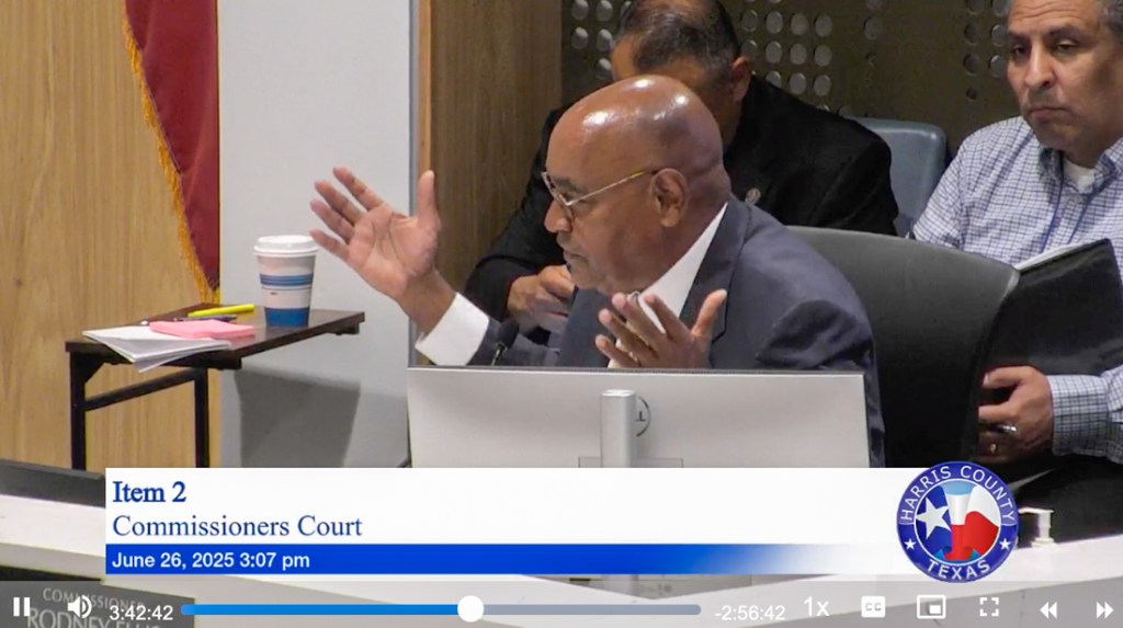
6/27/25 4PM – In a marathon discussion yesterday that stretched for hours, Harris County Commissioners Court struggled with how to plug a $1.3 billion shortfall in 2018 Flood-Bond funding. In the end, they voted 4-1 along party lines to apply all remaining flood-bond money exclusively to projects that ranked in the top quartile on Rodney Ellis’ Equity Prioritization Index.
Precinct 1 Commissioner Rodney Ellis arguing that remaining flood-bond funds be directed only to projects with a high “equity” component.
This will effectively defund all projects that fall into the second, third and fourth quartiles on Ellis’ Equity Prioritization Framework.
The Motion
Commissioners voted 4:1 to use all available flood-bond funds:
“To fully fund all current and future needs for projects in Quartile One, according to the 2022 Prioritization Framework, and direct the Harris County Flood Control District to work with court officers and report to Commissioners Court a project schedule by September 18th, 2025, on all future projects with a recommendation.”
Impact of Cuts
Precinct 3 Commissioner Tom Ramsey, the dissenting Republican, said, “It was like a bunker-busting bomb exploding yesterday. They blew up the 2018 bond program.” The decision will eliminate funding for 44 of the 48 bond projects that Ramsey had in his precinct.
“There’s no longer any money for them,” said Ramsey.
Ramsey will lose $424 million of flood-bond funding. He added, “Projects in the top quartile eat up every remaining available dollar in the bond. Every bit of it. There’s none left. Not a single dime.”
Only those marked with a #1 in the Quartile Column will be pursued at this point. The rest are effectively dead unless funding can be found elsewhere.
No Projects Left in Lake Houston Area
All HCFCD flood-bond projects in the Lake Houston Area fell below Ellis’ Equity Quartile #1 into the second, third, or fourth quartiles.
Following the Democratic plan will eliminate $20 million for Lake Houston Floodgates See Project G-103-Gates.
It will also eliminate any help for the Kingwood Diversion Ditch. The Kingwood Area Drainage Analysis called that the most important project in the area. And Kingwood experienced the highest flooding in the county during Harvey.
Chart showing feet above flood stage of 33 gages of misc. bayous in Harris County during Harvey.Gage on far left is Kingwood.
This doesn’t mean those projects will automatically die. But it is a setback.
It means project leaders will have to seek funding elsewhere for money that HCFCD had already committed years ago and that voters approved.
In that regard, Houston City Council Member Fred Flickinger had this to say about the Commissioner Court’s decision.
“Obviously the County’s handling of the flood bonds has been a concern for several years. Commissioner Ramsey is continuing to fight for our area to complete the necessary flood mitigation projects.
“However, regardless of the outcome at the County level, I have full confidence that the schedule I laid out in last year’s town hall meeting will in fact be held with the support of Representative Cunningham, Senator Creighton and Mayor Whitmire.”
Commissioner Ramsey also described the Gate project as his “Rubicon,” a reference to a Roman battle that represents a point of no return, i.e., a battle that must be won at all costs.
Uncertainty Surrounds 95 Active Projects
Ninety-five projects that fall into quartiles 2, 3 and 4 are listed as “Active.” HCFCD says it will move forward with any projects already in progress. But it’s unclear whether future stages will be implemented, i.e., moving from engineering to construction. We may know more in September.
HCFCD says they are moving forward with all HUD projects.
But GLO stressed the tightness of a February 28, 2027 deadline for 11 CDBG-DR projects valued at roughly $320 million. With only 20 months remaining to complete the projects, County Commissioners voted yesterday to take another three months to schedule projects.
For that group of projects, deadlines may be a bigger threat than funding. Think 17 months is plenty of time? It’s taken Harris County four years to get to this point with these projects! More uncertainty won’t speed things up.
Before the meeting, GLO Commissioner Dawn Buckingham warned county leaders to use the HUD funds “as quickly as possible.”
How Meeting Unfolded
Precinct 1 Commissioner Rodney Ellis, a master of political theater, packed the first two hours of Commissioners Court with surrogates during the public-comment portion of the meeting. The same people and groups that Ellis used to tarnish previous Harris County Flood Control District administrators showed up again. They even carried similar signs.
Over and over and over again, they complained about the lack of bond-program:
Equity
Results
Transparency
Dr. Tina Petersen, executive director of HCFCD, then led off the discussion with a PowerPoint presentation that she had been working to compile since February. The last slide shows how her team explored five different scenarios for maximizing available funding. (See her entire detailed report here.)
That set the stage for Precinct 1 Commissioner Rodney Ellis’ 20-minute boilerplate rant about historical discrimination against poor neighborhoods and how rich neighborhoods get all the money.
Disconnect between Ellis Rant and Reality
But there’s a basic disconnect between the rant and reality. Note that of all HCFCD spending since 2000, money has gone disproportionately to watersheds with a majority low-to-moderate-income (LMI) population. Between 2000 and 2022, 61% went to the one third of watersheds with an LMI-majority population. So, poor watersheds already receive the lion’s share of funding – almost twice as much as middle and upper income areas.
Busting the Myth: Between 2000 and 2022, in Harris county, poor, not rich neighborhoods have gotten the lion’s share of flood mitigation dollars since 2000.
Regardless, Ellis was on a roll. And by the time he was done, three of his Democratic colleagues (Hidalgo, Garcia and Briones) were demanding more equity.
They voted to ignore all five of the scenarios that Petersen spent months working on and focus only on projects that ranked high on Ellis’ equity scale.
When Ramsey pointed out that one of the poorest neighborhoods in Precinct 3, Barrett Station, was defunded, Ellis shot back that his equity formula was “agnostic” to politics. But the numbers tell a different story.
Expect frequent updates on this in coming months as the situation evolves.
To view video of the discussion, look for Item 2 here. Public appearances come before Item Two, and there are several breaks during the discussion.
Posted by Bob Rehak on 6/27/25 at 4PM
2859 Days since Hurricane Harvey
https://i0.wp.com/reduceflooding.com/wp-content/uploads/2025/06/20250627-Ellis-Item-2.jpg?fit=1100%2C616&ssl=16161100adminadmin2025-06-27 15:36:392025-06-27 23:43:12Remaining Flood-Bond Funds Going Only to Equity Projects
6/25/2025 – On February 7, 2025, Harris County commissioners, expressed concerns about budget shortfalls in flood-bond and subdivision drainage projects. They asked Harris County Flood Control District (HCFCD) for an accounting of where the money went and how much was left. One hundred and thirty-eight days later, after missing repeated deadlines, HCFCD filed the report below for Agenda Item #2 – one blank page. It has nothing on it. Nada. Zip. Bupkis. Zero.
This is what passes for “transparency” in Harris County and the Commissioners Court’s Orwellian world of double-speak. There’s a reason for this.
They’re trying to shift funds around without you knowing.
Commissioners Secretly Debating Scenarios for Dealing with Shortfall
I would hasten to add that Harris County Flood Control District (HCFCD) has shared information with commissioners, just notyou. And according to Commissioner Tom Ramsey of Precinct 3, all commissioners are engaged in a heated debate about five different scenarios for dealing with the shortfall.
Only one scenario would treat each precinct equally – Ramsey’s. The other four would take money from Republican Precinct 3 and give it to Democratic precincts.
For instance, under one scenario, Precinct 3 would get cut by $223 million while Democratic precincts would be cut only by an average of $120 million. So…
Precinct 3 would be cut $100 million more than other precincts.
According to Ramsey, they’re using “equity” to defend allocations that have nothing to do with equity. For instance, Barrett Station, an underserved neighborhood in Precinct 3 with flooding problems, would receive nothing under the Democratic funding scenarios.
Unacknowledged Scope Creep, Bloat, and Massive Slowdown
Another complaint that Ramsey has is about “scope creep.” Some line items in the flood bond were limited to engineering studies.
However, now that those studies are complete, some commissioners want to increase those limited financial commitments to include full-blown construction costs as well. That was never originally intended.
And when you factor in 27.5% inflation since the 2018 flood bond, you can understand why Democrats are grabbing Ramsey’s fair share.
Of course, they would never acknowledge that they created Harris County’s bloated, process-bound, equity-obsessed bureaucracy that has reduced HCFCD spending to pre-bond levels – making inflation take an ever larger toll on purchasing power.
That has also put essential, life-saving projects at risk. For instance, on the chopping block: the project to add more floodgates to Lake Houston. The flood bond allocated $20 million that is now at risk of going elsewhere.
GLO Takes Stand Against Partisan Politics, Encourages Speed
Ramsey has drawn a line in the sand on the floodgate issue in particular and the unfair allocation issue in general. He says he has talked with Texas General Land Office Commissioner Dawn Buckingham about the money grab.
According to Ramsey, Buckingham supports a fair and equal allocation of remaining bond funds among all precincts.
Buckingham issued this statement:
“My mission at the Texas GLO is to serve those we are supposed to serve and do it well. Since becoming Commissioner in 2023, I have put politics aside and done what is right for Harris County. Flood waters do not respect political boundaries, and neither should prioritization of resilience efforts. I encourage the Harris County Commissioners’ Court to put aside partisan politics and focus on maximizing effectiveness of the funds available as well as putting them to work as quickly as possible.”
Democrats may have a majority. But Ramsey likely has a bigger stick. Harris County cannot afford to lose Buckingham’s support at a time when her team is reviewing $850 million in Harris County grant applications with tight federal deadlines.
Will the other precincts share the pain? Will they vote for an equal allocation of the remaining funds? Or will they try to steal from Ramsey’s fair share?
How Did We Get Here?
The County’s complete and utter lack of transparency raises the question, “What are they trying to hide from us?” They have clearly forgotten that this is our money, not theirs. Where is it going? Why? Why can’t HCFCD move faster? And how are we to know whether remaining dollars are going where they are most needed? (HCFCD doesn’t publish flood risk data either.)
And most important: How are we to hold executives and elected officials accountable? We can’t without information.
This is the opposite of transparency. Secrecy will increase flood risk for large segments of Harris County’s population that have received little to no help from HCFCD up to now. Like the Lake Houston Area.
The thoughts expressed in this post represent opinions on matters of public concern and safety. They are protected by the First Amendment of the US Constitution and the Anti-SLAPP Statute of the Great State of Texas.
https://i0.wp.com/reduceflooding.com/wp-content/uploads/2025/06/Legislation-Details-On-Agenda-Item-2.jpg?fit=1275%2C1650&ssl=116501275adminadmin2025-06-25 17:47:592025-06-26 08:15:30Why HCFCD’s Report on Remaining Flood-Bond Funds is One Blank Page
6/24/25 – Representatives of the City of Houston District E Office, Houston Public Works, Kings Forest, and the Bear Branch Trail Association (BBTA) met this morning west of Kingwood High School. Purpose: to discuss clearing a drainage ditch that had been neglected for so long, it became seriously overgrown. So overgrown, in fact, that the ditch was almost impossible to see.
“Over there?”“Maybe over here?”“The map says it should be that way.”“GPS says it should be over here.”“Let’s send out a special recon unit.““This is going to be a tough one!”
Can You Spot the Water?
And then! Aha! Water! Can you see it below? It’s almost up to the level of Kingwood Drive…when it hasn’t rained for eight days. That’s how blocked the ditch was by vegetation!
See reflection to right of tree near bottom of frame.
One hundred and ten homes adjacent to this ditch flooded, not including the community meeting room. So did Kingwood High School. And Kingwood Drive which is a major evacuation route.
All that vegetation increases the risk of future flooding by backing water up.
Residents have been lobbying for years to get the City to address this issue. Now, it’s finally happening!
The Plan to Clear It
I don’t have anything in writing yet, but I think Public Works agreed to start from the downstream side which you see immediately below. The vegetation blocking the outflow needs to be removed and the culverts need cleaning out.
The ditch outfalls onto the Kingwood Country Club Lake Course and Lake Kingwood.
More vegetation in the median also blocks the flow and will be cleared.
Can you even see where the ditch crosses the median?
Next, they will work back north to clear the entrance to the culverts under the westbound lanes.
Then, they will continue working their way up the ditch removing blockages, including several trees that fell during Beryl last year.
After removing those, Public Works will ensure that the storm sewers leading from neighborhoods to the ditch are also clear and graded properly. Sediment currently blocks the outfalls backing water up into storm sewers and neighborhoods.
BBTA and Kings Forest representatives plus their residents emphasized that they don’t want the entire greenbelt scalped. They just want to remove enough vegetation to restore the flow as designed.
Chris Bloch of the BBTA Board hacked his way through the underbrush to help document the blockages. He said that Public works told him they hope to have the work started by the end of June and completed in July before the start of school.
Public Works also promised to evaluate the roadside ditches in Kings Forest to restore conveyance. But that will be a separate project.
Thank You!
Thanks to Houston District E City Council Member Fred Flickinger, and his staff members Dustin Hodges and Demari Perez. Thanks also to BBTA Board members Chris Bloch and Lee Danner for their assistance in documenting issues and granting access to their property.
Finally, thanks to the staff of Houston Public Works who showed up in the heat and humidity this morning. They braved poison ivy and mosquitoes the size of B-52 Bombers to help protect residents.
Posted by Bob Rehak on 6/24/25
2856 Days since Hurricane Harvey
https://i0.wp.com/reduceflooding.com/wp-content/uploads/2025/06/20250624-DSC_3016.jpg?fit=1100%2C733&ssl=17331100adminadmin2025-06-24 16:01:572025-06-24 23:09:04“I Know There’s a Drainage Ditch in There Somewhere”
“Pit capture” is when a river punches through the dikes of a sand mine and starts flowing through it.
Photographs taken on 6/22/25 from a rented helicopter show that the San Jacinto West Fork continues to flow into and through the two sand pits. Their dikes have not been repaired. And the river has rerouted itself through the pits which are on private property. See below.
Entry Breach at former Hallett Pit now owned by Riverwalk Porter LLC. West Fork now flows into pit (upper left) rather than following its normal course (bottom right).At the other end of the pit, the river flows back to its original channel (lower right).
At the northern end of the Hallett mine, the West Fork has captured another pit.
Water flows toward camera position through two dike breaches, instead of taking the long (slow) way around the curve.Looking downstream. Closer shot of entry point shows accumulated sediment in pit has already broken the water surface and that vegetation is taking over the old river bed.Made of sand, this dike was never very high, wide or strong. Little wonder the river breached it and captured the pit.
Best management practices recommend minimum 100-foot-wide, reinforced dikes to eliminate problems like this. That obviously wasn’t the case here.
So, do pit captures encourage or discourage downstream sediment buildups that contribute to flooding?
Industry Says Sediment Falls into Pits. But Does It?
The table below shows particle sizes that water moving at various speeds can transport.
Sediment Size
Diameter (mm)
Approx. Critical Flow Velocity for Initiation
Clay/Silt
<0.004
~0.5 ft/s (~0.34 mph)
Very Fine Sand
0.004–0.062
~1.5 ft/s (~1.0 mph)
Fine Sand
0.062–0.2
~2 ft/s (~1.3 mph)
Medium Sand
0.2–0.5
~3–4 ft/s (~2–2.7 mph)
Coarse Sand
0.5–2.0
~4–5 ft/s (~2.7–3.4 mph)
Very Coarse Sand
2.0–4.0
~5–6 ft/s (~3.4–4.1 mph)
Small Gravel
4–16
~6–7 ft/s (~4.1–4.8 mph)
Medium Gravel
16–64
~7–10 ft/s (~4.8–6.8 mph)
Conclusions:
Sediment deposited in pits is not permanently trapped.
Floods can churn up and flush out stored sediment.
Sediment transport becomes episodic and pulse-like.
Modeling studies show that even in pits 20-25 feet deep, floodwaters at 5 MPH can mobilize and carry away all but the largest gravel. Consequently, experts say sand-mining pits do not serve well as permanent sediment sinks. But are they adding to the sediment load downstream?
How Pit Capture Can Add to Sediment Loads Downstream
Numerous studies have examined whether pit capture makes downstream sedimentation better or worse. Generally, they indicate that pit captures tend to make downstream sedimentation worse—especially over the long term.
To summarize, these sources generally conclude that pit capture:
Results in channel instability and sediment pulses.
Worsens downstream sedimentation, contrary to any short-term sediment-trapping benefit.
Therefore, management efforts typically and strongly recommend preventing pit capture through:
Better engineering practices
Increased setback distances
Reinforced berms
Strategic sediment management planning.
For More Information or a Summer-Science Project
For those interested in learning more or for a summer-science project, consult the following:
Peer Reviewed and Technical Studies:
Kondolf, G.M. (1997). “Hungry water: Effects of dams and gravel mining on river channels.” Environmental Management, 21(4), 533–551.
Kondolf, G.M. (2001). “Geomorphic and environmental effects of instream gravel mining.” Landscape and Urban Planning, 28(2-3), 225–243.
Kondolf, G.M. et al. (2007). “Two Decades of Geomorphic Effects of Gravel Mining in the Tuolumne River, California.” Environmental Management, 40, 571–584.
Collins, B.D., & Dunne, T. (1990). “Fluvial geomorphology and river-gravel mining: A guide for planners, case studies included.” U.S. Geological Survey Special Report 98, California Department of Conservation.
National Marine Fisheries Service (NMFS) (2004). “Gravel Mining and Channel Stability: An evaluation of gravel extraction impacts on salmon habitat.”NOAA Technical Memorandum NMFS-NWFSC-66.
NMFS (2011). “Channel Processes and Sediment Transport: Implications for Salmon Habitat Restoration.” NOAA Technical Memorandum NMFS-NWFSC-115.
Texas-Specific Agency Reports:
TWDB (2020). “Lake Houston and San Jacinto River Watershed Study: Sediment Management and Flood Risk Assessment.” Texas Water Development Board, Austin, TX.
Texas Commission on Environmental Quality (TCEQ) (2019–2022). Multiple investigation and enforcement reports documenting pit breaches and sediment spills from sand mines along the San Jacinto River (publicly available through TCEQ’s Central File Room and online database).
TCEQ (2021). “Best Management Practices for Sand Mining in the San Jacinto River Watershed.” RG-555. Texas Commission on Environmental Quality, Austin, TX.
Texas Parks and Wildlife Department (TPWD) (2018). “Impacts of Gravel and Sand Mining on Instream Habitats and Fish Communities in Texas.” TPWD Inland Fisheries Division Technical Report IF-TM-2018-01.
SJRA (2021). “San Jacinto Regional Sediment Management Plan.” Harris County Flood Control District and SJRA joint publication.
Army Corps and HCFCD. “West Fork San Jacinto River Emergency Dredging Project Final Report (2019).”
“San Jacinto River Master Drainage Plan – Appendix F: Sediment Management (2021).”
Background and Context:
Langer, W. H. (2003). “A General Overview of the Technology of In-Stream Mining of Sand and Gravel Resources, Associated Potential Environmental Impacts, and Methods to Control Potential Impacts.” USGS Open File Report OF-02-153.
Bull, W.B., & Scott, K.M. (1974). “Impact of mining gravel from urban stream beds in the Southwestern United States.”Geology, 2(4), 171–174.
Posted by Bob Rehak on 6/23/25
2855 Days since Hurricane Harvey
The thoughts expressed in this post represent opinions on matters of public concern and safety. They are protected by the First Amendment of the US Constitution and the Anti-SLAPP Statute of the Great State of Texas.
https://i0.wp.com/reduceflooding.com/wp-content/uploads/2025/06/20250622-DSC_2689-copy.jpg?fit=1100%2C733&ssl=17331100adminadmin2025-06-23 19:56:052025-06-23 22:01:14West Fork Pit Captures Still Not Addressed After a Year
Houston, unlike most major cities, still boasts of vast wilderness areas nearby – largely because of the epic flooding problems they have. The wilderness among us somehow manages to attract people to an environment plagued by heat, humidity, frequent flooding and roaches as large as Buicks.
Wilderness is restful. It rejuvenates the spirit. It anchors us.
But in our zeal to live near wilderness, we destroy the very thing that attracted us.
You lose beauty, solitude and the sense of peacefulness that come from watching a deer born in your yard or an eagle land on your tree.
Photographed minutes after birth…outside my front door.
Today, a rented helicopter took me over one of the largest remaining wilderness areas in north Houston. It’s property owned by developers between Spring Creek and the West Fork, south of the Grand Parkway and north of Humble.
Regardless, people have plans to develop this property.
Looking northwest at the confluence of Spring Creek (left) and the San Jacinto West Fork (bottom).Farther west, we encountered this view at the northern end of Townsen Boulevard in Humble. Looking N across Spring Creek running left to right above the middle of the frame.As I snapped this shot, I pondered nature’s uniformity in randomness.
I couldn’t understand why such a large area so close to a major population center remained undeveloped. Then we flew north over it. Below are several representative shots.
The property is riddled with swamps and wetlands.Wading birds such as egrets, great blue herons, roseate spoonbills, ibis and more live here.Swamps stretched for miles. However, we did see dozens of deer stands in some of the higher areas.One hydrologist said homes in these areas should be built on stilts, like on the Bolivar Peninsula, to remain flood safe.
But homes are not being built on stilts.
As we flew north, we saw civilization consuming wilderness like a giant maw.
If developers, regulators and unsuspecting buyers pretend those wilderness areas will not flood, someone could be killed.
Repeat flooding could cause the area to deteriorate and adversely affect the value of homes on higher ground.
Areas downstream will be adversely affected by increased runoff.
Wildlife will be forced to move elsewhere, eliminating one of the primary attractions of the area.
Early buyers who wanted to live next to wilderness will be forced to move….again.
I wish the undeveloped swamp land could be turned into a nature park where people and wildlife could make peace with each other. And actually increase home values.
Posted by Bob Rehak on 6/22/25
2854 Days since Hurricane Harvey
The thoughts expressed in this post represent opinions on matters of public concern and safety. They are protected by the First Amendment of the US Constitution and the Anti-SLAPP Statute of the Great State of Texas.
https://i0.wp.com/reduceflooding.com/wp-content/uploads/2025/06/20250622-DSC_2708.jpg?fit=1100%2C733&ssl=17331100adminadmin2025-06-22 21:30:042025-06-22 21:36:54The Wilderness Among Us
6/21/25 – Callan Marine’s San Jacinto West Fork dredging placement area near Luce Bayou is filling up…rather quickly. The City of Houston began its most recent dredging program with Callan on December 20, 2024 – six months ago. The goal: to move 800,000 cubic yards of sediment out of the river near the headwaters of Lake Houston.
Position of dredge on Saturday, 6/21/2025 on West Fork. Looking N toward Royal Shores visible near top of frame on East Fork.Looking south toward FM1960 bridge at top of frame.
From here, Callan pumps the sediment approximately 3.8 miles across the East Fork and up Luce Bayou to a placement area near the Interbasin Transfer Canal.
Route of 18-inch dredge pipe to placement area.
West Fork Dredging Placement Area Filling Up Quickly
To hold the sediment, Callan built a placement area approximately 300,000 square yards by 8 feet deep. That magically works out to (drum roll please) about 800,000 cubic yards!
After removing trees, Callan scraped dirt into a series of berms with a series of internal dikes that force sediment-laden water through a maze. The circuitous route slows water down and allows sediment to settle out of suspension before Callan returns clearer water to Lake Houston.
This afternoon, that maze looked like this.
Luce Interbasin Transfer Canal on lower left. Placement area is more than a half mile long and three football fields wide.
Glare on the water partially masks the depth of sediment, but it’s more visible from a steeper, closer angle.
From the air, it appeared that sediment/water mixture reached within a foot or two of the enclosure’s outer walls.Reverse angle shows proximity to Lake Houston in background.Closer shot shows miniature river delta forming as water seeks its way through the maze. Note height of water relative to height of outer berms in upper left.Water shooting into placement area through 18 inch pipe.Side shot shows impact of stream.
To put the size of that pipe in perspective, a basketball is 9.5 inches in diameter. So, two could almost fit side by side in the pipe.
Outfall back to Luce Bayou and Lake Houston
This job was originally scheduled for a year and the dredge has been pumping for six months so far. At this rate, they may finish early.
Volume Shows Importance of Dredging District
The amount of sediment moved to the West Fork dredging placement area in six months underscores how important the passage of Charles Cunningham’s Dredging District bill was this year.
This has been a wet spring and more sediment keeps moving downriver every day. And we’re still playing catch up with past neglect.
Posted by Bob Rehak on 6/21/25
2853 Days since Hurricane Harvey
https://i0.wp.com/reduceflooding.com/wp-content/uploads/2025/06/20250621-DJI_20250621170919_0245_D.jpg?fit=1100%2C619&ssl=16191100adminadmin2025-06-21 21:15:282025-06-21 21:25:30West Fork Dredging Placement Area Filling Up
6/20/25 – Harris County Flood Control District (HCFCD) has announced that it will unveil the final design of the Woodridge/Taylor Gully Project in Kingwood on July 1. Based on preliminary engineering, HCFCD applied to the the U.S. Department of Housing and Urban Development (HUD) via the Texas General Land Office for a grant of $42 million to cover the cost of construction.
According to long-time residents, Taylor Gully never flooded, even during Harvey, until Perry Homes purchased and cleared the 270-acre Woodridge Village property immediately north of Sherwood Trails, Elm Grove and Mills Branch Villages. The property, just across the county line in Montgomery County, forms the headwaters of Taylor Gully and used to be heavily forested.
But shortly after Perry’s contractors started clearing the property, hundreds of homes along Taylor Gully flooded twice in 2019.
Rustling Elms near Taylor Gully in May of 2019
Engineering documents specified that the contractors should have cleared the property in sections and built detention basins for each section before moving onto the next. However, the contractors clearcut the whole property and sloped it toward the homes that flooded before building the required detention.
The fiasco turned into a giant class-action lawsuit. During the lawsuit, Perry’s contractors scrambled to build the stormwater detention basins. However, it also became clear that the detention they were building was about 30-40% short of Atlas-14 standards which Montgomery County had not yet adopted.
County/City Purchase Property from Perry
HCFCD and the City of Houston purchased the property from Perry to keep it from being developed. Early on, they announced plans to turn it into a giant regional stormwater detention basin to reduce flood risk.
Building another stormwater detention basin on Woodridge Village holding 412 acre-feet (virtually doubling capacity).
Expanding a portion of Taylor Gully and lining it with concrete.
Replacing the culverts at Rustling Elms with a clear-span bridge.
HCFCD entered into an Excavation and Removal Contract with Sprint Sand and Clay to get a head start on excavating the new Woodridge Basin. However, when HCFCD applied for HUD funding, by law, they had to terminate the contract. That happened at the end of 2023. Why? Conditions on the property can’t change while the GLO and HUD evaluate grants. It’s a fraud prevention measure.
New Excavation on Woodridge Village as of May 31, 2025
Generic Differences Between Preliminary and Final Design Recommendations
During preliminary engineering, managers try to prove up the value of a concept. But along the way to final design, they sharpen their pencils.
As a project progresses from concept to constructible plans, typically they tighten and incorporate:
Hydraulic and Hydrologic Modeling – with higher resolution topography, updated rainfall data, and detailed channel/basin geometry.
Right-of-Way and Easements – Whereas preliminary layouts assume general access needs, final design incorporates, precise right-of-way limits, utility conflicts, coordination with surrounding landowners, and legal descriptions for acquisition and/or dedication.
Geotechnical Investigations – Soil borings for slope-stability analyses for embankments, groundwater-level monitoring, channel linings, etc.
Structural-Design Finalization – Including sizes, materials, and load capacities for bridges , weirs and detention outlet structures.
Environmental and Permitting Integration
Cost Estimate Updates – Whereas preliminary estimates often have ±30 accuracy, final design includes detailed quantities, updates unit costs and construction phasing for more precise budgets and schedules.
Constructability and Value Engineering – Engineers and sometimes contractors look for ways simplify/reconfigure designs that lower costs.
Utility Coordination – Precise identification of existing utilities (water, sewer, fiber, gas) along with plans to relocate them if necessary or change design.
Public Involvement and Stakeholder Feedback – Where we are now. Feedback sometimes results in design modifications for aesthetics, access, noise or neighborhood concerns. It might also be valuable for inclusion of trails, parks or other recreational elements.
HCFCD has not yet released any of the specific changes between their preliminary and final plans for this property.
Preliminary plans called for replacing these culverts at Rustling Elms and Taylor Gully with a clear-span bridge like the one farther downstream.
HCFCD Hopes to Bid by October
According to HCFCD spokesperson Emily Woodell, “We’re wrapping up design for this project, which is what we plan to cover at the community engagement meeting. Based on current project schedules, this is set to go out for bid for construction contracts in October of this year.”
“We’re planning to amend this into the overall contract with the General Land Office in the very near future, which will allow us to draw grant funds. None of the design work has been funded by CDBG, it was all locally funded. Grant funds will be used for construction.”
HCFCD urges community members to attend the virtual meeting. Remember, it’s:
Tuesday, July 1, 2025
Starting at 6:30 PM
If you have suggestions after seeing the plans, now is the time to share them. So sign up now.
Posted by Bob Rehak on 6/20/25
2852 Days since Hurricane Harvey
https://i0.wp.com/reduceflooding.com/wp-content/uploads/2019/09/Elm-Grove-9.19_30.jpg?fit=1500%2C1000&ssl=110001500adminadmin2025-06-20 19:44:372025-06-20 19:58:22HCFCD to Unveil Final Design of Woodridge/Taylor Gully Project on July 1
6/19/25 – The first City-of-Houston Matching Grant Project designed to help beautify and reforest Kingwood was dedicated on Wednesday, June 18th. And City Council Member Fred Flickinger is working to make sure others will soon follow.
Hopefully, the Bear Branch Trail Association (BBTA) Project in the median of Kingwood Drive just east of Woodland Hills will be the first many similar projects.
The intersection looked like this before the start of the project.
“Before” shot, looking NE at Kingwood Drive median from across Woodland Hills. Note dense thicket of vines and underbrush behind signs.Photo Chris Bloch.
After Bear Branch Trails volunteers spent 200 hours cleaning out vines, deadwood and underbrush, they helped plant trees, shrubs and grass. When complete, the same area looked like this.
“After” shot of same area. Photo Chris Bloch. Blue-green color is hydromulch which should quickly sprout into grass.
Photos of Dedication Ceremony
(L to R) Lee Danner, BBTA; Debra Knebel, BBTA; Dee Price, KSA/Trees for Kingwood; and Chris Bloch, BBTA receive recognition from Council Member Flickinger.
See the extended team below.
(L to R) Tom Sanders, BBTA, Chris Bloch, BBTA; Vernon Autrey, A-Z Wright’s Tree Service; Dee Price, KSA/Trees for Kingwood; District E Council Member Fred Flickinger: Dustin Hodges, CoH District E; Lee Danner, BBTA; Paul Wright, A-Z Wright’s Tree Service; and Debra Knebel, BBTA.
Traffic visibility had become a major problem at this corner resulting in many traffic accidents. The improved visibility will help greatly.
How Project Came About
Early last year, the City announced it was willing to offer to match expenditures up to $5,000 for projects that improved the appearance of City-of-Houston property. The BBTA Grant application identified this section of the Kingwood Drive median as a project.
The application process for Matching Grants started on July 1st last year, as it does each year.
BBTA submitted its application in October, 2024. City Council Member Fred Flickinger approved the project, which uses money from his discretionary funds allocated to each Council Member. The City notified the Trail Association of the award in January of 2025.
BBTA generated and submitted a plan for approval to the City Department of Parks and Recreation. After approval, the project went out for bids to local landscaping contractors. A-Z Wright’s Tree Service won the bid and performed the final landscaping of the project which included planting seven more native trees, 17 bushes, and grass.
Total cost of the completed project was $10,224.15 of which the City will fund $5,000.
More Applications Being Accepted Starting July 1
The application period for 2025-2026 Matching Grant Projects will open on July 1st. Any Community Association or Trail Association in Kingwood can apply. Due to extensions granted after Hurricane Beryl last year, several grants are still pending. So more projects may soon follow that use 2024 funds.
In the meantime, Flickinger will sponsor an informational meeting at the Kingwood Community Center on Tuesday, 6/24/25, at 6 PM.
He invited all community and trail associations interested in enhancing the appearance of Kingwood to apply.
About Trees for Kingwood
Trees for Kingwood, which operates as part of the Kingwood Services Association has planted more than 3,000 trees to date. It is soliciting support from local businesses and individuals to help support Matching Grant Applications made by neighborhood organizations.
Posted by Bob Rehak on 6/19/25
2851 Days since Hurricane Harvey
https://i0.wp.com/reduceflooding.com/wp-content/uploads/2025/06/20250618-DSC_2561.jpg?fit=1100%2C733&ssl=17331100adminadmin2025-06-19 21:25:022025-06-19 21:37:00First Houston Matching Grant Beautification Project in Kingwood Dedicated