7/24/25 – Five pipelines carrying highly volatile liquids (HVLs) have become exposed and undermined by erosion associated with sand-mining activity near Caney Creek in Porter. Some of the pipelines have been shored up. Others hang suspended in mid-air. See below.
Exposed pipelines at northern end of Triple PG property near Caney CreekReverse angle shows proximity to Caney Creek in foreground.Side shot gives better view of utility-easement erosion at northern part of mine.
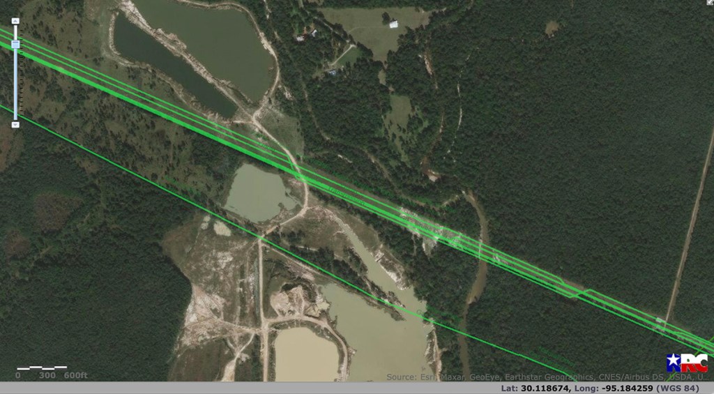
From Railroad Commission website in August 2021. Note how miners had started mining past Kinder Morgan pipeline on bottom. Compare this with photos above taken today that show pipelines exposed where clustered green lines are.
The exposed HVL pipelines observed today are part of a pattern at this mine. But it’s not the only dangerous pattern, in my opinion.
Attorney General Lawsuit on Behalf of TCEQ
Back in 2019, breaches of two dikes at the same mine were left open for months. The mines released process wastewater through those breaches into the headwaters of Lake Houston for months. They also let White Oak Creek flow through the Triple PG sand mine (now operated by Texas Frac Sand Materials, Inc.) directly into Caney Creek.
Both White Oak and Caney Creeks flow into the San Jacinto East Fork and the headwaters of Lake Houston, which supplies drinking water for 2.2 million people.
Looking N. from over Hueni Road. White Oak Creek (left) flows into and through Triple PG property.Still looking N but farther east, water flows out of the mine into Caney Creek(right of mine).Lake Houston is behind camera position.
Original Case Delayed Six Years
Legal maneuverings and a change in ownership of the mine through a series of shell companies and trust funds have delayed the original lawsuit for six years in Travis County courts. See Case No. D-1-GN-19-007086.
Texas Frac Sand Materials now operates the mine even though Dr. Prabhakar R. Guniganti and his family still own the property. See the Montgomery County Appraisal District record below for the part of the mine with the five exposed HVL pipelines.
MoCo Appraisal District record shows 1992 Guniganti Credit Shelter Trust owns the parcel outlined in blue where mining exposed pipelines.This one parcel is a small part of a much larger mine.
The Texas Commission on Environmental Quality (TCEQ) has already opened an investigation into both the pipeline and breach issues reported above.
Posted by Bob Rehak one 7/24/2025
2886 Days since Hurricane Harvey
The thoughts expressed in this post represent opinions on matters of public concern and safety. They are protected by the First Amendment of the US Constitution and the Anti-SLAPP Statute of the Great State of Texas.
https://i0.wp.com/reduceflooding.com/wp-content/uploads/2025/07/20250724-DJI_20250724140935_0601_D.jpg?fit=1100%2C619&ssl=16191100adminadmin2025-07-24 20:13:272025-07-24 20:15:32Five Highly-Volatile-Liquid Pipelines Exposed at Triple PG Mine on Caney Creek
7/23/25 – Ever wonder how someone could lose track of billions of tax dollars? It takes a lot of effort. But Harris County’s current Democratic leadership has proven adept at the task. Here are some of tricks of their trade.
1. Moving money around
That makes it more difficult to trace. Put Toll Road money into Flood Control. Put Flood Control money into Engineering. Then move it back again. And again. Establish a Flood Resilience Trust to supplement flood-bond funds. Then dissolve it. Never provide a full accounting. Whew. Even the county administrator couldn’t explain it clearly. Maybe that was the point.
2. Changing department heads and group managers
Replace professional hires with political hires. In Flood Control, Engineering, IT, Community Services. And 16 other departments. Then gut the management structure three or four levels beneath them. Lose institutional knowledge, project momentum and oversight capabilities.
3. Making the new department heads accountable to a new department
The County Administrator’s Office, for instance. It has had three heads in four years (David Berry, Diana Ramirez and Jesse Dickerman) and is searching for a fourth to replace Dickerman whose title is Interim Administrator. All within four years.
4. Replacing experienced professionals with political hires
Force remaining experienced professionals to do the work of the political hires…without a pay increase. One veteran professional, who needs to remain anonymous for fear of reprisals, told me, they’re “doing their best to drive off remaining staff, and not even bothering to find replacements. I am pretty sure it is well past the tipping point and the county is one disaster away from dysfunctional.”
5. Appealing routine Public Information Requests to the Texas Attorney General
Then if the AG upholds the request, charge thousands of dollars to email (months later) a PDF that was already sitting on someone’s computer.
6. Not updating websites
That makes it easier for Rodney Ellis to claim “Kingwood is getting all the money.” Parts of the HCFCD district website haven’t been updated for five years. See below.
Screen capture from Downloads page on 7/23/25 shows last update was November 2020.
That might enable people to quickly verify whether “Kingwood is getting all the money.” Make people dig for the information and pay for it instead.
8. Publishing spending updates annually that used to be monthly
The frequency of Flood Bond Updates has fallen off radically. That makes it difficult to track projects in near real time.
9. Hiring Consultants for $2 million to do the work of staff you lost
On the 7/10/25 commissioners court agenda, Item 250 was a contract extension with Berkeley Research Group, LLC for $1,995,000. The primary deliverable in this word salad seems to be a dashboard to help make projects’ status more visible. Of course, this could delay disclosure for additional months…as outsiders try to figure out what insiders can’t.
10. Not totaling columns of spreadsheets that stretch for dozens of pages
And don’t put headers on any pages past the first, either. Make people scroll back and forth until their eyeballs bleed or they give up. And make them perform complicated import/export procedures to total up columns that stretch to almost 40 pages.
11. Continually changing the way you allocate money to projects
At first it was on the basis of flood damage. But people could understand that. So, it changed. Over and over and over again. Until now, damage, flood risk and flood intensity have nothing to do with the formula for allocating flood bond money.
12. Not even telling people where bond money will go in the first place
Unlike the 2018 Flood Bond, Garcia’s 2022 $1.2 billion Bait-and-Switch Bond didn’t even tell people where money would be spent. Three years later, we still don’t know. So, no one can check on them.
Shortly before the vote on Garcia’s bond, commissioners agreed to give each precinct an equal share. That lasted until the day after the election. We’re still waiting to see where money is going. The County Engineer admits to spending $131 million in the last three years, but has published NO detail on what that money bought.
Is the current uproar over the flood bond an effort to deflect attention from more tax dollars that have gone MIA? We just don’t know.
Any one of these practices might be overlooked were it not for the presence of the others. But taken together, they feel like a concerted effort to “escape and evade” detection and accountability.
Posted by Bob Rehak on 7/23/25
2835 Days since Hurricane Harvey
The thoughts expressed in this post represent opinions on matters of public concern and safety. They are protected by the First Amendment of the US Constitution and the Anti-SLAPP Statute of the Great State of Texas.
https://i0.wp.com/reduceflooding.com/wp-content/uploads/2025/07/20250723-Taxpayer-Footprints-in-Shape-of-Dollar-Signs.jpg?fit=1100%2C733&ssl=17331100adminadmin2025-07-23 19:15:242025-07-23 20:19:59The Dirty Dozen: 12 Ways Harris County Makes It Hard to Track Your Tax Dollars
7/22/25 – State Representative Steve Toth has announced that he will run for U.S. Representative Dan Crenshaw’s seat in Congress. Yet Toth, who lives outside the District, has repeatedly voted against flood-mitigation measures vitally needed by the people inside the district that he now wants to represent.
That inspired a student, whose home flooded badly during Hurricane Harvey, to create this 2-minute, satirical video that brilliantly lampoons Toth. The student has asked to remain anonymous.
Click image to play. Two minute video about Toth’s vote against flood-mitigation measures vital to the people he now wants to represent.
Toth voted against bills to create a Lake Houston Dredging District three times – even when language was added the third time – in HB1532 this year – that would eliminate any tax impact. He also voted against HB13 designed to improve flood-warning systems.
Crenshaw Actions on Flood Mitigation
Crenshaw, on the other hand, has worked diligently to obtain flood-mitigation funding for projects in his district. He even helped muck out flooded homes in Elm Grove after Imelda.
Among other things, Crenshaw helped obtain funding for:
Emergency West Fork Dredging by the Army Corps of Engineers
TC Jester Detention Basin
Westador Detention Basin
Taylor Gully and Woodridge Village Drainage Improvements
Additional flood gates for Lake Houston
New bridge across the Kingwood Diversion Ditch
Harris County Flood Control District Channel Improvement projects
Kingwood High School Flood Gates
Home buyouts along West Fork
Home-elevation projects
I have known Dan Crenshaw since he first ran for office and have immense respect for him. He has worked hard to protect the people of this district by securing funding for numerous flood-mitigation projects. Steve Toth, on the other hand, has consistently voted against flood-mitigation measures. That tells me he’s out of touch with the needs of people in this congressional district. I plan on voting for Crenshaw.
Posted by Bob Rehak on 7/22/25
2884 Days since Hurricane Harvey
The thoughts expressed in this post represent opinions on matters of public concern and safety. They are protected by the First Amendment of the US Constitution and the Anti-SLAPP Statute of the Great State of Texas.
https://i0.wp.com/reduceflooding.com/wp-content/uploads/2025/07/20250722-Toth-Video-Keyframe.jpg?fit=1100%2C714&ssl=17141100adminadmin2025-07-22 15:25:562025-07-23 11:06:06Flood-Victim Video Brilliantly Lampoons Rep Who Consistently Voted against Flood Mitigation
7/22/25 – State Representative Steve Toth has announced that he will run for U.S. Representative Dan Crenshaw’s seat in Congress. Yet Toth, who lives outside the District, has repeatedly voted against flood-mitigation measures vitally needed by the people inside the district that he now wants to represent.
That inspired a student, whose home flooded badly during Hurricane Harvey, to create this 2-minute, satirical video that brilliantly lampoons Toth. The student has asked to remain anonymous.
Toth voted against bills to create a Lake Houston Dredging District three times – even when language was added the third time in HB1532 that would eliminate any tax impact. He also voted against HB13 designed to improve flood-warning systems.
Crenshaw Actions on Flood Mitigation
Crenshaw, on the other hand, has worked diligently to obtain flood-mitigation funding for projects in his district. He even helped muck out flooded homes in Elm Grove after Imelda.
Among other things, Crenshaw helped obtain funding for:
Emergency West Fork Dredging by the Army Corps of Engineers
TC Jester Detention Basin
Westador Detention Basin
Taylor Gully and Woodridge Village Drainage Improvements
Additional flood gates for Lake Houston
New bridge across the Kingwood Diversion Ditch
Harris County Flood Control District Channel Improvement projects
Kingwood High School Flood Gates
Home buyouts along West Fork
Home-elevation projects
I have known Dan Crenshaw since he first ran for office and have immense respect for him. He has worked hard to protect the people of this district by securing funding for numerous flood-mitigation projects. Steve Toth, on the other hand, voted against flood-mitigation measures. That tells me he’s out of touch with the needs of people in this congressional district. I plan on voting for Crenshaw.
Posted by Bob Rehak on 7/22/25
2884 Days since Hurricane Harvey
The thoughts expressed in this post represent opinions on matters of public concern and safety. They are protected by the First Amendment of the US Constitution and the Anti-SLAPP Statute of the Great State of Texas.
https://i0.wp.com/reduceflooding.com/wp-content/uploads/2025/07/Toth-video-keyframe.jpg?fit=1100%2C664&ssl=16641100adminadmin2025-07-22 12:59:042025-07-22 12:59:05Flood-Victim Video Brilliantly Lampoons Rep Who Consistently Votes against Flood Mitigation
7/21/25 – One remaining utility conflict in the receiving pit of a bore under UnionPacific Railroad Tracks is still forcing the Northpark expansion contractor to play hopscotch construction. This morning, crews worked all around the two bore pits but not in them or on them.
The bore is necessary to connect drainage on both sides of the tracks. And the bore must be completed before contractors can begin roadwork on top of the drainage. The pictures below, taken this morning, show where construction stands at the end of July 2025.
When complete, the Northpark expansion project will provide the first all-weather evacuation route from Kingwood. That’s important because during major flood events, such as Hurricane Harvey, Kingwood Drive can be cut off by high water. The expansion project includes a bridge over 494 and the railroad tracks, giving 78,000 a quick route to higher ground.
Bore Pits Under Tracks
This is the bore pit contractors are using to force two 5′ steel pipes under the tracks.
East of tracks in front of Self U Storage
And this is the receiving pit west of the tracks. Note the utility line bisecting the pit on a diagonal.
Receiving Pit west of tracks where junction box will eventually go.
According to Lake Houston Redevelopment Authority, all work within UPRR right of way is currently on hold pending approval of a modified work plan needed to: a) address a recommended shoring method which is b) needed to remove a “previously unknown abandoned water line in conflict with the bore alignment.”
It’s always something in construction. Meanwhile…
Northpark Eastbound from 59 to Loop 494
Work continues between 59 and Loop 494.
Note how all the old concrete has been removed in the center of the roadway. The left/south side of the road has also been cleared all the way from 59 to 494.Contractors have begun pouring concrete in front of the dry cleaners at 494 and eastbound Northpark.
Northpark Eastbound from Railroad Tracks
Farther east across the railroad tracks, clearing for surface lanes is complete and grading has begun (right of current roadway).
Looking E. A six lane bridge over the tracks will eventually be built between the concrete on the left and the graded area on the right.
Northpark Eastbound at Russell Palmer Road
Construction of the right turn lane at Russell Palmer Road is virtually complete.
Looking SE at Intersection of Russell Palmer and Northpark.Only a small, curved section of the turn-lane construction remains in front of the Mermaid Car Wash.Looking SW from Northpark and Russell Palmer. A long stretch of the eastbound lanes (left) is now virtually complete back past the entrance to Kings Mill.
Northpark Westbound by Sun Auto
Looking W. Sidewalk work has started next to the Sun Auto on the north, outbound side of Northpark.
This phase of sidewalk construction will go from Sherwin-Williams Paint to Self-U Storage next to the railroad tracks.Looking W. A new development called the Northpark Enclave on the left has finished grading and installing drainage. Meanwhile, westward expansion of the surface lanes (right) has stalled in front of Public Storage (orange) because of the bore issue.
Loop 494 Northbound
Elsewhere…
Looking N along Loop 494. Crews have finished a new northbound surface lane south of Northpark and are installing drainage before paving another.Looking S along Loop 494 opposite Slim Chickens.
Light-pole foundations on the south/eastbound side of Northpark are currently on hold due to conflicts.
Check back next month for more adventures in hopscotch construction.
Posted by Bob Rehak on 7/21/25
2883 Days since Hurricane Harvey
https://i0.wp.com/reduceflooding.com/wp-content/uploads/2025/07/20250721-DJI_20250721072815_0522_D.jpg?fit=1100%2C619&ssl=16191100adminadmin2025-07-21 14:15:082025-07-21 14:20:35Utility Conflict Still Forcing Hopscotch Construction on Northpark
7/18/2025 – Harris County Flood Control District (HCFCD) under the county’s current Democratic leadership has not put a high priority on improving flood risk in the San Jacinto watershed. That’s despite the fact that the San Jacinto had the highest flooding in Harris County during Harvey. And almost half of the deaths due to Harvey occurred in Kingwood.
“Put Your Money Where Your Mouth Is”
An analysis of spending in all Harris County watersheds shows where the focus has been to date. The table and graphs below show the county’s true priorities.
“Put your money where your mouth is” means you back up your words with action. But that is not happening with 2018 Flood Bond money. Promises made long ago have not been kept. Words do not match actions.
One caveat about the numbers below: During the initial days of the bond, HCFCD contributed money to the Army Corps to complete projects the Corps had been working on in several watersheds: Brays, Hunting, Clear Creek and White Oak. That skewed the figures below slightly.
Total and Construction Spending by Watershed To Date
The table below shows dollars budgeted to each watershed in the 2018 bond. It also shows how much has been spent in total and against construction to date. It is arranged by descending order in the “% Spent” Column. Only one watershed has gone over budget to date: Carpenters. It had three small projects. The other watersheds range from almost 90% spent to 4%.
Critical Role of Construction in Reducing Flood Risk
Preliminary engineering reviews, feasibility studies and design are absolutely necessary to document the need for a project, determine its scope, and bid it. But they don’t reduce flood risk one iota. They only talk about how to do it.
Only when someone actually starts turning dirt during construction does flood risk start to come down.
The bar graph below compares “total budgeted dollars,” “total dollars spent,” and “construction dollars spent” for each watershed in the 2018 bond.
Note the huge variation in all three columns. The blue “budgeted” bars show the most dramatic difference from high to low.
Beyond that, note how White Oak, Cypress, Greens and Brays are close to $200 million in spending to date and how all four have more than $100 million in construction spending.
Now compare that with the San Jacinto Watershed. It had the fifth largest budget. But…
The San Jacinto ranks second from the bottom both in terms of “% Spent” and “% of Construction $ Spent.”
Other Lake Houston Area watersheds such as Spring Creek, Luce Bayou and Cedar Bayou show similar disparities.
This is not an accident. The cherry-picked metrics in the Rodney Ellis’ Equity Prioritization Framework favor other watersheds and no longer even include flood risk.
Critical Role of Construction
Construction is the most critical component of spending. Historically, it comprises the largest share of a project life cycle.
Eight years after Harvey and seven after passage of the flood bond, we’ve only spent about 17% of the total budget on construction.
Beyond that, comparing individual watersheds with the Brays Bayou watershed shows tremendous disparities in construction spending.
Halls Bayou, for instance, has the highest percentage of people in the county making less than the median income for the region. It also suffered the most “damage per square mile” in five major storms (Harvey, Imelda, Tax Day, Memorial Day and Allison). See below how it compares to Brays, where Rodney Ellis lives.
Halls had far more dollars allocated than Brays, but Ellis’ formula put Halls residents at the back of the bus compared to where he lives in the Brays Bayou watershed.
Halls Bayou was budgeted to receive 55% more dollars than Brays. But it has received far less than half of Brays’ total funding to date. And far less than a quarter of Brays’ construction spending!
The San Jacinto story is similar.
The bond promised the San Jacinto watershed more than Brays. But Brays has received 4 times more total dollars and six times more construction dollars to date.
The Great Irony
We should be coming into the home stretch with this bond money. Far more than half should have been spent by now and far more construction should have been completed or in progress.
The great irony is that both total and construction spending are decreasing when they should be increasing.
I have been told by many people that capacity among construction contractors is not the issue.
From HCFCD Activity Page. Shows spending through Q2 25. Both overall and construction spending would continue to decline even if first half spending were annualized.
And despite having more than $3 billion left to spend, with only one watershed over budget to date by a tiny amount, HCFCD’s Director is talking about a $1.3 billion shortfall without providing any public explanation about her projections. And commissioners are using that as an excuse to cancel projects in watersheds that have received minuscule funding to date.
Posted by Bob Rehak on 7/20/2025
2882 Days since Hurricane Harvey
The thoughts expressed in this post represent opinions on matters of public concern and safety. They are protected by the First Amendment of the US Constitution and the Anti-SLAPP Statute of the Great State of Texas.
https://i0.wp.com/reduceflooding.com/wp-content/uploads/2025/07/Budgeted-v-Spent-Table-e1753063622548.png?fit=1100%2C624&ssl=16241100adminadmin2025-07-20 21:13:002025-07-22 23:15:59Why You Still Live with Higher Flood Risk than Necessary
7/19/25 – Eight years after Harvey, we still don’t have new flood maps. That creates flood-risk uncertainty.
Harris County Flood Control District (HCFCD) has yet to release flood maps based on Atlas-14 data developed 4 years ago. HCFCD says it is waiting for FEMA to approve its maps, but FEMA delays have dragged on for years. And FEMA doesn’t need to approve the maps for many purposes.
Meanwhile, studies have found that flood-risk uncertainty may be causing lenders to raise mortgage rates and credit requirements. It’s also causing insurers to leave markets with uncertain risk or not renew policies that may be a mortgage requirement.
The ripple effects of flood-risk uncertainty affect everyone. But they weigh most heavily on low-to-moderate income (LMI) groups with less discretionary income. Those groups may find themselves priced out of the housing market as lenders and insurers seek to cover their uncertain risks.
Worse, any resident – rich or poor – may unknowingly buy a home that they thought was flood safe only to see a flood destroy it.
Ripple Effects of Flood-Risk Uncertainty
Studies show that flood-risk uncertainty may:
Induce people to buy homes they think are safer than they really are
Cause mortgage lenders to tack extra points onto their mortgages or raise downpayment requirements
Lead lenders to force buyers to purchase flood insurance they may not need
Increase flood-insurance rates to a level that makes monthly mortgage payments unaffordable for many.
Those factors affect all income groups. But those with lower incomes and less job security feel the greatest impact and may find themselves priced out of markets.
Spreading Impacts of Uncertainty
This week, First Street Foundation hosted a fascinating hour-long webinar about how FEMA cuts will impact real estate, lending, home buying, home building, and insurance markets.
The uncertainty affects tolerance for risk in all those markets. No one knows yet how the National Flood Insurance Program (NFIP) will be affected.
But the absence of up-to-date flood maps, or any flood maps at all in some cases, complicates that risk. A New York Fed study in 2024 found that lenders were more reluctant to originate loans in “hidden-risk” zones. When they do, they loan less, charge higher rates, impose stricter credit requirements, and may resell the mortgages to offload risk. The study also found “This effect is weaker for high income applicants.”
I know the owner of a billion-dollar bank who has withdrawn entirely from residential mortgage lending because of the uncertainty.
Federal Government Shedding Risk
According to First Street, policy shifts at the federal level seem intended to transfer the risk of weather disasters onto property owners, investors, lenders, and local governments.
Example: Instead of subsidizing flood insurance like it used to, FEMA’s new Risk-Rating 2.0 is making NFIP rates more closely reflect losses.
On average, NFIP policy costs have increased 35% under Risk-Rating 2.0 so far. And annual rate increases are capped by law.
Meanwhile, developers continue to build in risky areas, elevating homes only enough to meet the outdated requirements of flood maps developed 20 to 50 years ago. Most people underestimate the risk associated with that.
No Legal Reason to Wait for FEMA
Some people think that only FEMA can release flood maps. That’s not true. Only FEMA can release maps used by NFIP as the basis for national flood insurance. But states and counties can release their own maps for their own purposes.
Counties elsewhere have done so to help guide development, make regulatory decisions, establish stormwater detention standards, raise building codes and improve floodplain management.
The District, submitted its new maps to FEMA and expected FEMA to issue new preliminary flood-insurance rate maps by Spring or Summer in 2022. That didn’t happen.
Screen Capture from June 2021 MAAPnext update.
HCFCD then issued a statement in July 2022. For unspecified reasons, it said it would wait and “… follow FEMA’s formal, regulatory FIRM [flood insurance rate map] update process.” (Despite other urgent, non-insurance-related needs.)
Some claimed at the time that Precinct 2 Commissioner Adrian Garcia held up release of the new maps to enhance his re-election chances. I have been unable to verify that. But one thing is certain.
Nothing legally prevents HCFCD from releasing its flood maps.
Yet as you read this, developers in Harris County and surrounding areas are filing permit applications to build infrastructure and homes in areas that will likely flood. One fought all the way to the Texas Supreme Court for the right to build in a flood-prone area.
And Ryko wants to build 7,000 homes in another flood-prone area west of Kingwood. Just one problem: the homes could be under 7 to 25 feet of water – or more – if we get another Harvey.
Unsuspecting families who buy such homes based on antiquated flood maps face huge flood and financial risk.
Unrecognized risk is also wreaking havoc in the insurance market. ChatGPT produced this table of insurers withdrawing or reducing coverage in high-risk states.
State
Insurers Withdrawing or Reducing Coverage
California
State Farm, Allstate, AIG, Chubb
Florida
State Farm FL, Farmers, AAA, UPC Insurance (exited), plus others post-2004
Louisiana
~20 insurers left high-risk parishes; Lighthouse went insolvent
Across coastal/high-risk states
AIG, AXA, Chubb pulling back
In Texas, I’m not aware of any insurers leaving the state. At least, not yet. But several (State Farm, Farmers, and Allstate) have reportedly restricted coverage. They do that primarily through non-renewals at policy expiration if flood-risk changes (i.e., with new maps) or a property experiences a flood loss.
Make New Flood Maps Public Now
Concealing information from people that puts their lives and life savings at risk is just plain cruel.
To keep residents safe, give them the best available data NOW. And let them decide how much risk they can tolerate based on fact, not fiction.
Posted by Bob Rehak on 7/19/2025
2881 Days since Hurricane Harvey
https://i0.wp.com/reduceflooding.com/wp-content/uploads/2021/07/MAAPnext-Timeline.jpg?fit=1200%2C714&ssl=17141200adminadmin2025-07-19 15:30:402025-07-19 16:28:39Is Flood-Risk Uncertainty Redlining Your Neighborhood?
7/16/25 – Brays Bayou, the watershed where Harris County Precinct 1 Commissioner Rodney Ellis lives, has received virtually as much capital-improvement spending as 12 other watersheds put together. The county has 23 watersheds in all. So…
Ellis’ watershed received as much capital-improvement funding as half of all other watersheds combined.
For this analysis, I focused on Capital Improvement spending because it actually reduces flood risk. Maintenance usually keeps flood risk from getting worse.
The 12 “have not” watersheds include:
Bottom 12 watersheds in HCFCD Capital Improvement Project Spending between 2018 Q3 and 2025 Q2
In contrast, Ellis’ watershed benefited from $170.58 million in capital improvement spending.
Highest Flooding, Lowest Funding
Among the 12 are the San Jacinto River and Spring Creek Watersheds. They had the highest flooding in Harris County during Harvey.
Chart showing feet above flood stage of 33 gages of misc. bayous in Harris County during Harvey.
Capital Improvement spending from all sources between the start of the flood bond in 2018 and the end of 2025 Q2.
To see CIP spending, select “CIP” under the Project-Group filter on the left. That removes “maintenance expenditures.” Now dig deeper.
“District Funds” Even More Skewed
As I explored the data, I found another inequity. The District has spent $281 million from its own budget since 2018 Q3 (as opposed to bond or partner funds). To see this, leave CIP selected and select “District Funds” under Fund Source.
The seven watersheds at the bottom received a tiny percentage of Brays – Ellis’ watershed.
Ellis’ watershed (Brays) also received the lion’s share of this pot of money – almost $58 million. More than one fifth of all District Funds spent in seven years went to the watershed Rodney Ellis lives in.
Meanwhile, the San Jacinto Watershed – the county’s largest – received only about $3 thousand. That’s 17,000 times less.
District Funds spent in the San Jacinto watershed don’t even round to one-hundredth of a million dollars– only $3,430.
By almost any metric you look at, you see the same discrimination. Consider “construction” spending. Why? Money spent on upfront engineering studies and land acquisition doesn’t reduce flood risk one iota until someone actually starts turning dirt. Real reductions in flood risk begin with construction.
Ellis’ watershed received $126.58 million to date in construction spending. But the San Jacinto watershed has received only $18.49 million – one seventh of what Ellis gave himself.
It’s good to be king of commissioners court. You even get to filibuster about how Kingwood is getting all the money while Greens and Halls get none.
Download the spreadsheet on the HCFCD Activity page above the Power BI tables. Sort the 13,155 invoices paid to date since the start of the flood bond. You will see that…
Greens Bayou received $112 million capital improvement construction dollars; Halls Bayou received $27 million and Kingwood received ZERO.
No Fairness, No Future
The language and project lists associated with the 2018 flood bond were promises designed to reassure voters that the bond money would be distributed fairly throughout the county. So far, that promise has been broken.
And there’s no hint that the distribution of aid would be any better if we voted another $5 billion. This Commissioners Court has ignored the requirements in the bond language that voters approved.
And with the 2022 Bond which had a billion dollar drainage component, they first pledged an equal distribution of funds among precincts. Then AFTER voters approved the bond, they reversed their own motion.
I fear for the future of Harris County if this unfairness continues. Why would anyone vote for another bond?
Posted by Bob Rehak on 7/16/25.
2879 Days since Hurricane Harvey
The thoughts expressed in this post represent opinions on matters of public concern and safety. They are protected by the First Amendment of the US Constitution and the Anti-SLAPP Statute of the Great State of Texas.
https://i0.wp.com/reduceflooding.com/wp-content/uploads/2025/07/CIP-Thru-2Q25.png?fit=2430%2C1746&ssl=117462430adminadmin2025-07-16 17:00:102025-07-17 07:10:21The Inequities of Equity: Ellis’ Watershed Receives as Much CIP Spending as 12 Others Put Together
7/15/25 – Texas State Representative Steve Toth of Conroe announced today that he will run for U.S. Representative Dan Crenshaw’s job next year in the Second Congressional District. But Toth, who is campaigning on protecting our security, has repeatedly voted against it.
Toth: Ultra-Right Mr. No
Toth voted against HB-13, designed to improve warnings in natural disasters, such as the July 4 Hill-Country floods this year and Panhandle wildfires last year. As of this writing, 134 are confirmed dead in the floods and close to a hundred are still missing.
Toth also voted against proposals to create a Lake Houston Dredging District three times: 2021, 2023 and 2025. The last time, State Rep. Charles Cunningham even modified the wording of HB 1532 so that it would NOT be tax-funded. But Toth still voted against it.
In the last redistricting effort, Toth helped redraw his home outside to Texas District 2, which he now wants to represent. Voter registration records indicate he lives in Texas District 8.
The ultra-conservative, far-right Toth also has a reputation for campaigning against Republicans. He previously ran against Kevin Brady of the Woodlands and lost.
A Personal Endorsement for Crenshaw
I have known Dan Crenshaw since he first ran for office and have immense respect for him. He has worked hard to protect the people of this district by securing funding for numerous flood-mitigation projects including dredging. But Toth has consistently voted against creating a Lake Houston Dredging District. He even voted against it when it wouldn’t have raised taxes. That tells me he’s out of touch with the needs of people in this congressional district. I plan on voting for Crenshaw.
Flickinger Emphasizes Vital Need For Dredging
Houston City Council Member Fred Flickinger who testified in favor of Cunningham’s Dredging District Bill said: “House Bill 1532 is arguably the most important piece of legislation for the Lake Houston area passed in the last several decades.”
“HB 1532 created a dredging district, which allows us to address sediment in Lake Houston and the tributaries flowing into it proactively rather than reactively after our area has flooded.
Slightly different versions of the dredging district bill were introduced in the previous two sessions, but failed thanks in part to Toth.
Said Flickinger, “Last May’s rain event was a perfect example of how dredging improves drainage. The San Jacinto River crested two feet lower than predicted due to the dredging which had been completed over the last several years.”
Flickinger credits Congressman Crenshaw, former Representative Huberty, Senator Creighton and Council Member Martin for that. “They deserve special credit for securing the funding to complete these dredging efforts, some of which are ongoing today.”
Toth is UN-Representative
I just don’t get why someone who wants to represent 13,000 families and 3,300 businesses that flooded in the Lake Houston area would vote against a dredging bill that helps protect them. Those 3,300 businesses represented 44% of all the businesses in the Lake Houston Chamber.
Overall, 20% percent of homes and 40% of businesses in the Lake Houston area have been affected by flooding. That last figure includes 100% of ALL businesses in Kingwood Town Center.
I know families that were destroyed financially by the flooding and people who were killed. But the man who wants to represent this area has repeatedly stood in the way of a bi-partisan, tax-neutral solution designed to protect their homes and businesses.
Posted by Bob Rehak on 7/15/2025
2877 Days since Hurricane Harvey
The thoughts expressed in this post represent opinions on matters of public concern and safety. They are protected by the First Amendment of the US Constitution and the Anti-SLAPP Statute of the Great State of Texas.
https://i0.wp.com/reduceflooding.com/wp-content/uploads/2018/10/Harvey-SanJac_437exposureadj.jpg?fit=2000%2C1054&ssl=110542000adminadmin2025-07-15 18:03:282025-07-15 18:11:04Toth, Who Voted Against Warning System, Dredging-District Bills Running Against Crenshaw
7/14/25 – I incorrectly reported four totals in my 7/12/25 story about the revised 2025 first-quarter, flood-bond update. I would like to set the record straight. I would also like to apologize to people at the Harris County Flood Control District (HCFCD) and my readers. I take great pains to present accurate, reliable information that readers can count on. And I want to correct the historical record for future reference.
What Happened
In the first iteration of the 2025 Q1 report, I found a billion-dollar discrepancy. HCFCD admitted the mistake and corrected it in the revised report.
While double checking the revised report, I thought I discovered some other inconsistencies between the high-level, summary information at the front and the backup documentation at the end. They included:
“Bond Funds”
“Partner Funds”
“Secured Funds”
“Funds Spent”
Unfortunately, the discrepancies resulted from an inaccurate automated export of data from a PDF file to Microsoft Excel. Four lines out of hundreds did not translate properly. Using different, third-party software, HCFCD did the same export/import operation and encountered the same problem.
Highlighted and enlarged translation error from PDF to Excel. Note how expenditures became misaligned.
So, the incredibly dedicated person I talked to manually copied and pasted hundreds of figures to double check the totals in a ten-page spreadsheet.
That led to the discovery of the translation error, which explained the inaccurate totals.
During the translation, the programs shrank the size of the type. So, the figures no longer appeared in their proper columns. They also became virtually invisible because of their small size.
New Totals Agree
After hours of checking, I’m confident that the totals in the documentation now agree with the claims in the introduction. For the record:
2018 Bond Funds = $2.5 billion
Partner Funds = $2,697,565,889 (rounded to $2.7 Billion)
Total Funds = $5,227,103,996 (rounded to $5.2 billion)
Total Spent to Date = $1,569,557,746.
Questions about Other Figures Still Unanswered
In my 7/12/25 post, I also raised other questions that HCFCD has not yet answered.
First, where does the half-billion dollar increase in work in progress during the first quarter come from? I don’t see it in construction activity on the ground, in bids, or in work approved by Commissioners Court.
Second:
Where does the $1.3 billion funding shortfall came from that HCFCD Executive Director Tina Petersen claimed in Commissioner Court?
Why did no mention of the shortfall appear in the 2024 Year-End Bond Update or either of the two first-quarter updates?
A Start on Answers
HCFCD is starting to work on answers to those questions. Regarding the $1.3 billion shortfall, an HCFCD spokeswoman said, “One of the big asks was to produce our (sometimes rough) estimates of unmet need. That fell into two categories:
Current unmet need – Funding needed to take current projects through construction, even if the bond only originally provided funds for a study or engineering work. A good example of this is the projects included in Bond ID F-14. (Planning, Right-Of-Way Acquisition, Design and Construction of General Drainage Improvements Near Kingwood.)
Future unmet need – Funding needed to take the next phase of a project through construction. Examples would include engineering work that showed we need channel conveyance improvements and a stormwater detention basin in an area, but we currently only have funding for the stormwater detention basin. Or if studies showed we could construct a four-compartment basin, but we currently only have funding for two compartments.
“That is not how we have managed the bond program to date, so it represented a shift in thinking. These were meant to be high-level estimates for discussion, not an actual estimate of need associated with the bond program.”
Working to Make Financial Reporting More Transparent
In working with HCFCD to resolve these an other questions, I found them very open and collaborative. At this point, I no longer feel they are trying to hide something.
I also have a greater appreciation for the complexities the 2018 bond program. Finding a way to summarize changes in scope on hundreds of projects and Bond IDs is difficult, especially when tracking money from multiple sources. From a communication point of view, it all comes down to inspiring trust instead of raising skepticism.
HCFCD has not yet agreed to any specific changes. But they did accept the challenge to find clearer ways to communicate.”
Posted by Bob Rehak on 7/14/2025
2876 Days since Hurricane Harvey
The thoughts expressed in this post represent opinions on matters of public concern and safety. They are protected by the First Amendment of the US Constitution and the Anti-SLAPP Statute of the Great State of Texas.
https://i0.wp.com/reduceflooding.com/wp-content/uploads/2025/07/Translation-Error.png?fit=2198%2C542&ssl=15422198adminadmin2025-07-14 18:02:312025-07-14 18:04:54Correction to Revised 2025 First-Quarter Flood-Bond Update Story