9/2/24 – On 8/26/24, the Texas Commission on Environmental Quality (TCEQ) issued a report on a San Jacinto West Fork pit capture. “Pit capture” happened when the river cut through an abandoned sand pit on a point bar instead of taking the long way around it. Worldwide, many environmental consequences have been linked to such pit captures. However, the TCEQ report never mentions the phrase.
This report does not discuss other pit captures that happened elsewhere in the West and East Fork watersheds earlier this year.
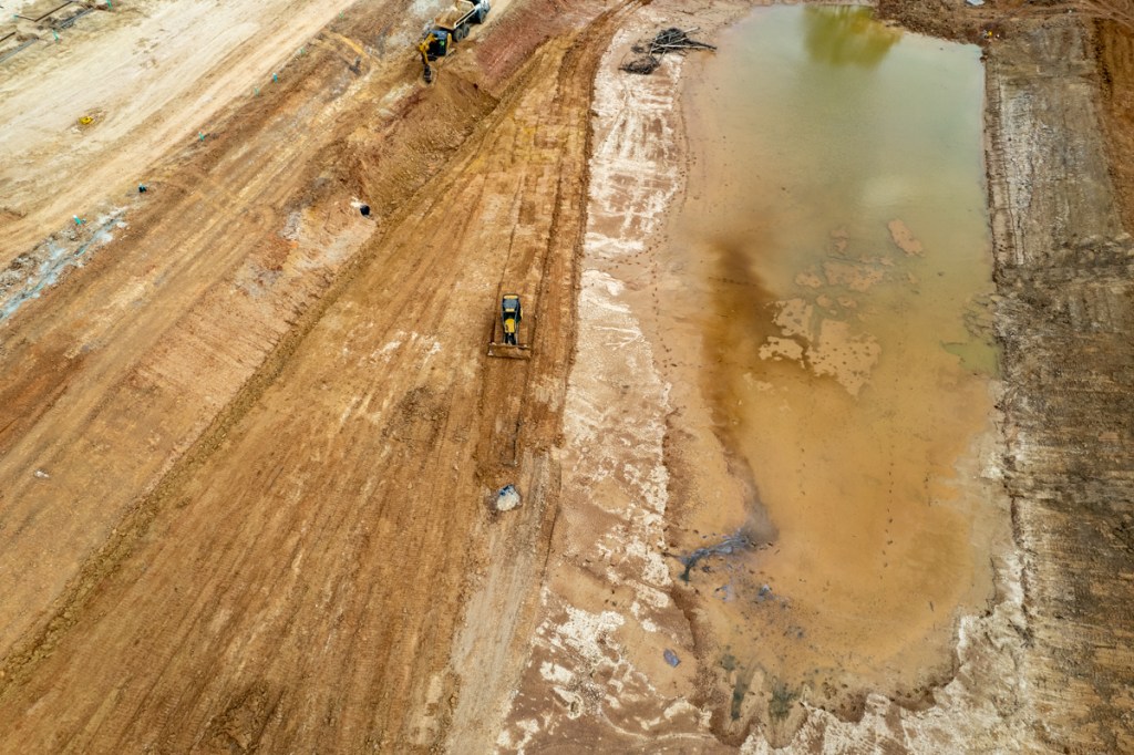
San Jacinto West Fork entering pit and abandoning its normal channel on May 22.
The TCEQ report, which took four months to investigate, compile and release, did not:
Refer to any water-quality measurements, even though the complaints concerned water quality.
Address other sand-mine dike beaches and emissions in the same area
Explore downstream impacts.
Result in any reprimands, letters of enforcement, or violations.
TCEQ Finds No Problems
The four-month effort resulted in no action. Apparently, the TCEQ feels that since the pit is no longer being actively mined, it is no longer a threat to the public. It simply concludes that the incident falls within their “enforcement discretion” and they chose not to take any action.
Approximate location of entry and exit breaches relative to island with Native-American cemetery.
Who Operated This Pit?
The report also ignores a complex web of interlocking corporations involved with West Fork sand mining. They include, but are not limited to, Hallett Materials, RGI, JR Development and the Rasmussen Group, headquartered in Des Moines, Iowa.
The first paragraph of the report states that the investigation was conducted to “evaluate compliance for RGI Materials, Inc. of the Porter Plant site located north of the West Fork San Jacinto River.” [Emphasis added.]
But the report lists GPS coordinates for a pond on the south and west sides of the river. It also shows photos of the pit on the south and west sides.
The report cites information obtained through a Jacob McCurry and identifies him as a Vice President of RGI Materials. But the Hallett Materials website lists Jacob McCurry as its Operations Manager.
The report never mentions Hallett, the largest operator on the West Fork. Hallett:
Operates a settling pond directly across the river from the pit that TCEQ investigated. That pond has been leaking almost continuously into the river since January through another pit that RGI used to own.
The Texas Secretary of State shows that RGI is an assumed name of Hallett Materials.
It’s all very confusing. Except for the TCEQ report’s conclusion. The TCEQ is taking no action.
Erosion of Cemetery
In 2018, I met Kurt Rasmussen at the Hallett plant. Rasmussen is part of the family that controls Hallett, RGI, and JR Development.
He gave me a tour of the captured pit on the south and west sides of the river. He also told me that Hallett was prohibited from mining that island in the middle of the pit because it is a Native American burial ground.
As a result of the pit capture, dikes no longer protect that island from the river and erosion.
Burial ground (upper left) in middle of pit captured by West Fork. Photo 5/13/24.
Unmentioned Problems with Pit Captures
The TCEQ report never mentions “pit capture.” Nor does it mention any of the problems associated with pit capture discussed in academic literature.
Where a river enters a pit, erosion typically migrates upstream (headcutting). That can lead to more river bank erosion. (You can already see it happening in the photo above on the right.)
Literature about pit captures also suggests that when rivers take a direct path through a sand pit, it can shorten the river’s length. This can increase the river’s gradient (slope) downstream, leading to faster water flow and more aggressive erosion.
Captured pits can act as sediment traps when water moves slow enough for sand to drop out of suspension. But when water moves as fast as it did in the May flood, it can stir up sediment and transport it downstream.
I measured the speed of water moving through the captured Hallett/RGI/JR Development/Rasmussen/Riverwalk pit at 5 miles per hour. That’s enough to pick up and transport large grains of sand.
This can contribute to increased sedimentation in downstream reaches, affecting water quality, habitat, and the morphology of the river.
Downstream from pit capture above at the confluence of Spring Creek and the West Fork. West Fork is on right.
That sediment began dropping out of suspension where the water slowed as it approached the headwaters of Lake Houston.
Kingwood Diversion Ditch blocked at River Grove Park, downstream from confluence above.Dredging cost estimated at about $750,000.
The increased flow velocity after a sand pit capture can also lead to downcutting that disconnects the river from its floodplain, reducing the ability of the floodplain to absorb floodwaters and support wetland habitats.
Scientific reports also say that such downcutting can reduce the level of the water table and destroy riparian vegetation.
TCEQ Ignores Downstream Consequences
TCEQ concluded with the words: “the discharge from this pond has been granted enforcement discretion.” TCEQ chose not to issue any violations.
Their decision apparently stems from the fact that the pit is no longer actively used for mining. According to the report, the current owner, Riverwalk Porter LLC, claims it intends to use the property (and presumably the graveyard within it) for “recreational purposes such as hunting and camping.”
It’s unclear how TCEQ’s ruling will affect boating on the river. The public waterway now cuts through private property. Will boaters be trespassers?
The thoughts expressed in this post represent opinions on matters of public concern and safety. They are protected by the First Amendment of the US Constitution and the Anti-SLAPP Statute of the Great State of Texas.
https://i0.wp.com/reduceflooding.com/wp-content/uploads/2024/09/20240513-DJI_20240513075313_0604_D.jpg?fit=1100%2C619&ssl=16191100adminadmin2024-09-02 11:05:022024-09-02 15:46:15TCEQ Report on West Fork Pit Capture Doesn’t Mention “Pit Capture”
6/8/24 – Today, I discovered another sand pit captured by the San Jacinto West Fork. I also discovered two more pits with breached dikes. That makes at least four San Jacinto West Fork sand pits seriously damaged by the last storm.
The West Fork has now captured a pit that Hallett owned until earlier this year and another that it still owns.
Let’s look at each. See the photos below.
Photos Taken on 6/8/24
Pit Capture #1
I discovered the first pit capture in mid-May and photographed it again today.
Looking from over West Fork at blocked channel and former Hallett pit. River now runs through the pit.
Hallett sold this mile-long,, half-mile-wide pit to a real estate company called Riverwalk Porter LLC in January, just days before the first breach at the downstream end. The breach at the northern end, in the foreground above, happened in May.
Pit capture is a phenomenon where the river cuts through one side of a mine and out the other. Watch it happen in this table top experiment.
Pit Capture #2
I discovered a second pit capture today. The river punched through one side of the pit and now flows out the other. It’s taking a shortcut through the pit, rather than going around like it used to.
Note how the river curves way out to the upper left in the photo. The inside of that curve used to be what geologists call a point bar. Such areas usually contain finely sorted sand. And indeed, historical images in Google Earth show trucks pulling sand from river banks before Hallett started mining here.
Hallett pit on another point bar, also captured by West ForkRiver flows from top to bottom.
Ironically, this area was being considered by the SJRA for its sand trap study. They may have to reconsider that now.
Breach #1
Another pit purchased from Hallett by Riverwalk Porter LLC also drains directly into the West Fork. Nothing holds it back now.
The area around the pipe has expanded into a chasm.
Breach #2
Farther north, Heidelberg Materials Southwest Agg LLC owns another pit that now drains into the West Fork.
Looking S from over West Fork (bottom left) toward Heidelberg Property.
Historical satellite images of the Heidelberg property show that they started mining it decades ago. Then they sold the mine to another company and recently repurchased it. While this particular area is recovering, the company appears to be mining other areas around it.
And look what’s happening downstream from the breach above. Could this be a third pit capture in the making?
Downstream at the same pond, the river looks as though it could soon punch through another narrow dike. Photo taken 5/22/24.
If and when this happens, the river could then route itself through the pit above. That would make at least three pits captured on the West Fork.
There may be more breaches and pit captures that I have not yet found.
Geomorphic Processes Accelerated to a Human Time Scale
It’s interesting to watch geomorphic processes at work on a human time scale. It’s also disconcerting to know that without help from miners and the TCEQ – which did not establish setbacks of mines from rivers until 2021 – the West Fork would have much less sediment pollution.
See below.
Confluence of Spring Creek (left) and San Jacinto West Fork (right), where all of the sand mine breaches above area.
If you wish to lodge a complaint with the TCEQ, go to this web page. Last time I heard, they only inspect the river once every three years unless citizens file complaints.
Posted by Bob Rehak on 6/8/24
2475 Days since Hurricane Harvey
The thoughts expressed in this post represent opinions on matters of public concern and safety. They are protected by the First Amendment of the US Constitution and the Anti-SLAPP Statute of the Great State of Texas.
https://i0.wp.com/reduceflooding.com/wp-content/uploads/2024/06/Hallett-North.jpg?fit=1100%2C619&ssl=16191100adminadmin2024-06-08 21:54:082024-06-09 09:52:54Another Sand Pit Captured, More Breached by San Jacinto West Fork
At the abandoned Williams Brothers sand mine on the San Jacinto West Fork, a strip of land – approximately 400 to 500 feet long and up to 50 feet wide – collapsed into the river during the flood in late January.
The dramatic erosion, during a relatively minor (2-5-year) rain event, dramatizes the destructive power of moving water and the need for greater setbacks from the river for sand mines. It also raises questions about abandonment plans for sand mines.
Resident Photo From Boat Shows Collapse
A resident who frequently boats the river and wishes to remain anonymous supplied the picture below. As the resident said, “All that dirt went somewhere. And it didn’t go upstream.”
Looking upstreamadjacent to Williams Brothers Mine south of Kingwood Drive
Aerial Shots Show Extent of Damage
From the air, the same location looks like this.
Williams Brothers Mine on right. Eagle Sorters Mine top left. Note extent of fresh sand on left.Same area from lower angle. Note how trees collapsed into river.Note also how erosion has eaten half of maintenance road around mine.
Where Trees Once Stood
Compare that with the satellite image below from Google Earth taken last year. Note how there used to be a row of trees on each side of the road. Now, trees remain only on one side.
The measuring tool Google Earth shows the width of the eroded strip was approximately 50 feet.
Most of the trees on the river side of the road are now floating down the river somewhere.
Blankets of Fresh Sand Everywhere
The resident who took the first shot above (the one from the boat) has lived near the river for 40 years. He says he’s never seen so much fresh sand deposited in a flood. See below.
Fresh sand flanks both side of the West Fork.Note trail of trees in water.
The images above show the power of moving water. One cubic foot of fresh water weighs 62.4 pounds. And more than 20,000 cubic feet per second moved down this reach of the West Fork during the peak of the January flood. That’s a lot of force on sandy soil.
We Must Plan for River Migration
That force was magnified by the way a river meanders. On the outside of curves, water accelerates. That extra speed accelerates erosion and creates what geologists call the cut bank.
Conversely, water travels less far and slower on the inside of a curve. As a result, sand is often deposited there in what geologists call point bars. Learn more in this post about Why Rivers Move.
Over time, erosion on one side of a river and deposition on another tends to exaggerate curves. Geologists call that process river migration. River migration already broke through the dike of one sand mine slightly upstream.
During the January flood, water flushing through that mine likely contributed to the buildup of sand blocking the Northpark drainage ditch near Northpark Woods.
Looking upriver along West Fork. Red arrow indicated where West Fork migrated through dike of abandoned sand mine.
Note in the photo above that the Northpark Ditch is now blocked by sand higher than ditch itself. This blockage suddenly appeared during the Jan. ’24 flood. It is backing water up toward Northpark Woods and Oakhurst in the upper right. At least some of the sand was likely flushed out through the breach in the dike above.
Need Greater Setbacks from the River For Sand Mines
As I stated in the beginning, this dramatizes the need for greater setbacks from the river for sand mines. At one time, there was no minimum distance.
In November 2021, after years of work by Bill McCabe and the Lake Houston Flood Prevention Initiative, TCEQ adopted new Best Management Practices (BMPs) for sand mining in the San Jacinto River Basin.
The new rules specify “A minimum 100-foot buffer zone is required adjacent to perennial streams greater than 20 feet wide, 50 feet for perennial streams less than 20 feet wide, and 35 feet for intermittent streams.”
Clearly, that may not be enough. For a list of what other states specify, see the Sand Mining page of ReduceFlooding.com.
Posted by Bob Rehak on 2/27/2024
2363 Days since Hurricane Harvey
https://i0.wp.com/reduceflooding.com/wp-content/uploads/2024/02/20240216-FullSizeRender.jpg?fit=1100%2C619&ssl=16191100adminadmin2024-02-17 18:29:392024-02-22 08:52:58River Bank Collapses, Taking Half of Sand Mine Road
The San Jacinto West Fork has turned into a sludge fest again. I took the picture below on 11/11/23. Not since the day that the West Fork turned white have I seen the contrast so dramatic at the confluence with Spring Creek.
Looking NW from over US59 Bridge. Confluence of Spring Creek (left) and San Jacinto West Fork (right). Cypress Creek joins Spring Creek 2.7 miles west of this location.
In that prior case, the cause was obvious. Two sand mines were discharging process wastewater into the West Fork. The TCEQ determined that one, the Liberty Materials mine, dumped 56 million gallons of white sludge into the river.
This time, the cause is not so obvious. I can’t even be certain I determined the cause. After taking the photo above, I spent a whole day ruling out various possibilities while searching for others.
Ruling Out Causes
The dramatic difference was not caused by huge variation in rainfall totals across the region.
The highest total on the West Fork was that 2.68 inches south of Conroe at SH242. Further investigation showed that 1 inch fell between 3 and 4PM on 11/09/23. That was the highest intensity at that gage in more than a month.
Uneven soil saturation across the region would also not cause the zebra pattern in the river. The entire region is still rated either “abnormally dry” or in “moderate drought.”
And Lake Conroe did not release any large volumes of water lately that would have scoured river banks. That eliminated another potential cause.
Now here’s where it gets really baffling.
SJRA Study Claims Most Sediment Comes from Spring/Cypress Creeks
The San Jacinto River Basin Master Drainage Study by Freese & Nichols claims that more sediment comes down Spring and Cypress Creeks than the West Fork.
In fact, they say, of all the sediment coming into Lake Houston, two thirds comes from Spring and Cypress Creeks while only 13% comes from the West Fork upstream of US59. So where is all the sludge coming from?
In my opinion, it most likely came from new developments or sand mines that move large volumes of loose sediment.
So the next day, I went out with my drone and found several possibilities.
Possible Sources for Sediment Pollution
Two sand mines had pits open to the river, but I did not see large volumes of sediment oozing out of them as I sometimes do.
The most interesting possibility: new developments very near that gage on SH242 that read 2.68 inches.
Two connected developments straddle FM1314 immediately north of SH242. Early plans called them both Mavera. But now, the one on the east has a sign that says Mavera. The sign on the west section calls it Evergreen.
Most of the development’s stormwater drains into Crystal Creek and then into the West Fork about a half mile downstream from where I took this photo.
Sediment-laden stormwater burst through the wall of this detention basin.Enlarged detail from shot above shows water was strong enough to destroy the outfall pipe.
Now let’s see what’s upstream from this breach.
Evergreen drainage channel. Water flows toward camera and the breached detention basin.Even farther up the channel. Note all recently exposed sediment.
The ditch above appears to be much wider than it was in January 2021, almost three years ago. Now, let’s jump back south to where this area drains into the West Fork.
Crystal Creek (middle) empties into the West Fork (bottom left). Note how milky water from Crystal comparesto the West Fork.
Note that the picture above was taken two days after the heaviest recent rainfall, so the volume may not seem impressive.
There likely were other areas along the West Fork that contributed to the sedimentation you saw in the first photo at the top of this post. But I was not in a helicopter and it’s virtually impossible to cover the entire river with a drone. So I can’t say for sure.
How to Report Issues You May See
This is not the first time I have documented excessive sediment coming off the West Fork.
The zebra effect at the confluence is common.
The angle of the shots above varies. But in each instance, the West Fork is the most polluted branch.
Why is sediment so concerning? After all, it’s natural, right?
When sediment reduces the conveyance of rivers, they come out of their banks faster and higher on smaller rainfalls. The rivers flood more frequently and increase your flood risk.
So, if you see unnatural situations in rivers or streams, make sure you report them to the TCEQ, which investigates such matters.
Together, we may be able to improve our safety and water quality.
Posted by Bob Rehak on 11/13/2023
2267 Days since Hurricane Harvey
The thoughts expressed in this post represent opinions on matters of public concern and safety. They are protected by the First Amendment of the US Constitution and the Anti-SLAPP Statute of the Great State of Texas.
The 2023 legislature scorecard, just five years after Hurricane Harvey, shows that flooding is fast becoming forgotten in Texas. Of the seven issues I tracked, the Lake Houston Area had two wins, four losses, and one that could be ruled a coin toss depending on your point of view.
Due to last minute heroics, HB 1 contained enough money earmarked for more gates to keep the project alive. A last minute phone-call campaign by hundreds of citizens making thousands of phone calls to key state legislators in the House and Senate succeeded in getting riders attached to the budget bill.
Few projects have inspired more hope among residents in the northeastern part of Harris County than the one to add more floodgates to the Lake Houston Dam. The Lake Houston Area Flood Task Force identified the project as one of the top priorities for the area.
The idea: to release water both earlier and faster in advance of major storms to create more storage in Lake Houston. Right now, Lake Conroe can release water 15 times faster than Lake Houston. And the release from Lake Conroe during Harvey was widely seen as one of the contributing factors to the flooding of so many homes and businesses in the Lake Houston Area.
The governor signed HB 1 on 6/18/23. It becomes effective on 9/1/23. With funding secured, Houston Mayor Pro Tem Dave Martin says final design on the gates is proceeding.
The TCEQ was under sunset review this year. No one proposed eliminating the TCEQ. But many people had ideas to improve it. They focused on two main areas: increasing transparency and improving enforcement.
The Sunset Commission recommended measures to improve public outreach, public notices, community input, and dissemination of public information, including the publication of best practices for sand mining.
The Commission also recommended updating the TCEQ’s enforcement practices to better focus on the riskiest actors and ensure staff treat potential violations consistently and based on severity.
These companion bills would have transformed the Harris County Flood Control District into the Gulf Coast Resiliency District. The new District would have been governed by a board appointed by the Governor instead of management hired by Harris County Commissioners.
The idea: to create regional solutions that benefitted all residents of Harris County, not just those that scored high on an equity formula.
The County fought the bill(s) tooth and nail. Each failed to get out of committee.
The bill died in the House Natural Resources committee. It never even got a public hearing.
This bill would have required sand mining companies to post financial surety that would guarantee cleanup of mines before they were abandoned. Abandoned mines on both the San Jacinto East and West Forks are littered with the remains of once thriving operations. But when the sand played out, the miners walked away, leaving a legacy of blight for the public to clean up.
Abandoned dredge in mine on North Houston Ave. in Humble.Property is unfenced so kids can play on equipment.
HB5341: Lake Houston Dredging and Maintenance District
This bill also died in the House Natural Resources committee. House Bill 5341 would have created a Lake Houston Dredging and Maintenance District. Its purpose would be to remove sediment, debris, sand, and gravel from Lake Houston and its tributaries to restore, maintain, and expand the Lake to mitigate storm flows.
This bill died in the Senate Finance committee. Senate Bill 1366 would have redirected surplus revenue from the economic stabilization fund to the Flood Infrastructure Fund. The State’s Flood Infrastructure Fund (FIF) has turned into one of the main sources of funding for Texas Water Development Board grants and one of the main ways that smaller counties and cities can fund flood projects.
HB 1540 passed. The bill implements reforms recommended by the Sunset Review Committee for the the San Jacinto River Authority. Many of those are good and needed reforms. They include provisions governing:
Gubernatorial designation of the presiding officer of SJRA’s board of directors;
Specific grounds for removal of a board member;
Board member training;
Separation of the board’s policy-making responsibilities and the staff’s managementresponsibilities;
Maintenance of complaint information; and
Public testimony at board meetings.
Approval should have been a rubber stamp. But at the last minute, Rep. Will Metcalf from Conroe offered an amendment that effectively fired Jace Houston, SJRA’s general manager and leader of the SJRA’s fight to reduce subsidence. The amended bill passed the Senate. Houston resigned effective 6/30/23. And now the Lone Star Groundwater Conservation District has no one to challenge unlimited groundwater pumping in Montgomery County.
Some in the Lake Houston Area who flooded during Harvey may rejoice at Houston’s departure. But differential subsidence is tilting Lake Houston upstream. It could make the Lake Houston Dam two feet higher relative to areas upstream near the county line. That could eliminate the safety margin above the floodplain for many homes in the next big flood.
Modeling shows 3 feet of subsidence near Harris/Montgomery county line, but only one foot at Lake Houston Dam.
As someone who had floodwater lapping at his foundation, I personally would put this one in the loss column.
The governor signed the bill on 6/18/23. It goes into effect on 9/1/2023.
Posted by Bob Rehak on 7/2/23
2133 Days since Hurricane Harvey
The thoughts expressed in this post represent opinions on matters of public concern and safety. They are protected by the First Amendment of the US Constitution and the Anti-SLAPP Statute of the Great State of Texas.
Tomorrow is the fifth anniversary of Hurricane Harvey. Many in the Lake Houston Area have asked, “Are we safer now?” The answer is yes, but we have a long way to go to achieve all our goals. Here’s a five-year flood-mitigation report card. It describes what we have and haven’t accomplished in 29 areas. So get ready for a roller coaster ride. I’ll leave the letter grades to you.
Lake Houston Area Mitigation
1) Dredging
The most visible accomplishment in the Lake Houston Area since Harvey is dredging. The City and Army Corps removed approximately 4 million cubic yards of sediment blocking the West and East Forks. Before dredging, River Grove Park flooded six times in two months. Since dredging, it hasn’t flooded once to my knowledge.
West Fork mouth bar after Harvey and before dredging. Now gone, but not forgotten.
Potential location for new tainter gates east of the spillway portion of the dam (out of frame to the right.
3) Upstream Detention
To reduce the amount of water coming inbound during storms, the San Jacinto River Basin Master Drainage Study identified 16 potential areas for building large stormwater detention basins. Unfortunately, they had a combined cost of $3.3 billion and would only reduce damages by about a quarter of that.
So, the SJRA recommended additional study on the two with the highest Benefit/Cost Ratio. Their hope: to reduce costs further. The two are on Birch and Walnut Creeks, two tributaries of Spring Creek near Waller County. Expect a draft report in February next year.
Funding these would likely require State assistance. But the Texas Water Development Board’s San Jacinto Regional Flood Planning Group has just recently submitted its first draft report. The draft also recommended looking at detention basin projects on West Fork/Lake Creek, East Fork/Winters Bayou, and East Fork/Peach Creek.
Building them all could hold back a foot of stormwater falling across 337 square miles. But funds would still need to be approved over several years. We’re still a long way off. Results – on the ground – could take years if not decades.
4) “Benching”
The Regional Flood Planning Group also recommended something called “benching” in two places along 5 miles of the West Fork. In flood mitigation, benching entails shaving down a floodplain to create extra floodwater storage capacity. Like the detention basins, benching is still a long way off…if it happens at all.
5) West Fork Channel Widening
Finally, the Regional Flood Planning Group recommended widening 5.7 miles of the West Fork to create more conveyance. But again, at this point it’s just a recommendation in a draft plan.
San Jacinto River Authority
6) SJRA Board Composition
After Harvey, many downstream residents accused SJRA of flooding downstream areas to save homes around Lake Conroe. At the time, SJRA’s board had no residents from the Humble/Kingwood Area. So Governor Abbott appointed two: Kaaren Cambio and Mark Micheletti. Cambio later resigned due to a potential conflict of interest when she took a job with Congressman Dan Crenshaw. That leaves Micheletti as the lone Humble/Kingwood Area resident on a seven-person board. However, the SJRA points out that the Board’s current president, Ronnie Anderson, represents Chambers County, which is also downstream.
State Representative Will Metcalf, who represents the Lake Conroe area, introduced a bill to limit SJRA board membership to upstream residents. Luckily for downstream residents, it failed.
7) Lake Conroe Lowering
SJRA identified temporary, seasonal lowering of Lake Conroe as a strategy to reduce downstream flood risk until completion of dredging and gates projects in the Lake Houston Area. The lowering creates extra storage in the lake during peak rainy seasons. After SJRA implemented the plan, Lake Conroe residents objected to the inconvenience. They sued SJRA and the City, but lost. After discussion with all stakeholders, the SJRA quietly modified its plan. It still lowers the lake, but not as much.
8) Lowering Lake Houston
Houston also started lowering Lake Houston, not seasonally, but in advance of major storms. The City has lowered the lake more than 20 times since beginning the program. That has helped to avoid much potential flooding to date.
9) Lake Conroe Dam Management
SJRA applied for and received several TWDB grants to enhance flood mitigation and communications in the San Jacinto River Basin. One involves developing a Lake Conroe Reservoir Forecasting Tool. SJRA has also worked with San Jacinto County to develop a Flood Early Warning System.
Finally, SJRA’s Lake Conroe/Lake Houston Joint Reservoir Operations Plan is on hold pending completion of the City’s plan to add more gates to the Lake Houston dam. Such projects may help reduce the risk of releasing unnecessarily large volumes of water in the future.
However, the location is controversial. Geologists say it wouldn’t reduce sediment in the area of greatest damage. Environmentalists worry that it could increase sedimentation through a “hungry-water” effect and open the door to river mining. And I worry that, even if successful, the pilot study would not be extendable. That’s because it relies on partnerships with sand miners. And other tributaries to Lake Houston do not have sand mines or as many sand mines.
Sand bar blocking West Fork after Harvey. The Corps has since removed it.
Federal Funding
It’s hard to get good grades on your flood mitigation report card without funding.
$1.6 million for HCFCD for Taylor Gully stormwater channel improvement.
$1.6 million for HCFCD for Kingwood Diversion Channel improvement.
$1.67 million for Harris County for the Forest Manor drainage improvement project in Huffman.
$8.2 million from FEMA the Westador Basin stormwater detention project on Cypress Creek.
$9.9 million from FEMA for the TC Jester storm water detention basin on Cypress Creek.
Crenshaw also has backed community requests for more funding in Fiscal 23. They include:
$8 million for the Lake Houston Dam Spillway (Gates).
$10 million for the Woodridge Stormwater Detention Basin (see below).
$10 million for a Cedar Bayou Stormwater Detention Basin.
Harris County Flood Control
19) Channel Maintenance and Repair
Harris County Flood Control has already completed several maintenance projects in the Lake Houston Area. In Kingwood, those projects include Taylor Gully, Ben’s Branch, parts of the Diversion Ditch and other unnamed ditches. In Atascocita, HCFCD also completed a project on Rogers Gully. Upstream, HCFCD is working on the third round of repairs to Cypress Creek. Batch 3 includes work at 12 sites on 11 channel sections. I’m sure the District has maintenance projects in other areas, too. I just can’t name them all.
Bens Branch near Kingwood High School after sediment removal.
In 2019, uncontrolled stormwater from the Woodridge Village development twice flooded approximately 600 homes in Elm Grove Village and North Kingwood Forest. HCFCD and the City purchased Woodridge from Perry Homes last year. HCFCD soon thereafter started removing sediment from the site to create a sixth stormwater detention basin that would more than double capacity on the site. At the end of last month, contractors had removed approximately 50,000 cubic yards out of 500,000 in the contract. This gives HCFCD a head start on excavation while engineers complete the basin’s final design.
21) Local Drainage Study Implementation
HCFCD authorized four studies of the drainage needs in the Lake Houston Area. They completed the Huffman and Kingwood studies. Atascocita and East Lake Houston/Crosby started earlier this year and are still underway.
The Kingwood study measured levels of service in all channels and outlined strategies to improve them to the 100-year level. The first two projects recommended: Taylor Gully and the Kingwood Diversion Ditch. Neither has started construction yet. But see the notes under funding above.
The Huffman Study recommended improvements to FM2100, which TxDOT will handle. It also recommended dredging in the East Fork near Luce Bayou which the City has completed. Finally, it recommended a bypass channel for Luce. However, pushback from residents forced cancellation of that project.
22) Buyouts
HCFCD completed buyouts of 80+ townhomes on Timberline and Marina Drives in Forest Cove last month. Contractors demolished the final run-down complex in August. That should improve property values in Forest Cove.
Completion of demolition of one of the last Forest Cove Townhome Complexes in July 2022.
23) Regulation Harmonization
Harris County Flood Control and Engineering have been working to get municipalities and other counties throughout the region to adopt certain minimum drainage regulations. I discussed the importance of uniformly high standards in last night’s post. So far, about a third of the governments have upgraded their regs. A third are still deciding whether to act. And the remainder have taken no action. There has been little movement in the last six months.
City of Houston
As mentioned above, the City has taken a lead role in dredging, adding gates to Lake Houston, and proactive lake lowering. In addition, the City has helped with:
24) Bridge Underpass Clean-Out
The City of Houston successfully cleaned out ditches under Kingwood Drive and North Park Drive in at least six places. Bridges represent a major choke point during floods. So eliminating sediment buildups helps reduce flood risk in areas that previously flooded.
Excavation of Bens Branch under Kingwood Drive by City crews.
The lowest score on the flood-mitigation report card probably goes to LSGCD.
26) Subsidence
The Lone Star Groundwater Conservation District has started pumping groundwater again at an alarming rate. Projected subsidence near the Montgomery County Border equals 3.25 feet, but only 1 foot at the Lake Houston dam. That could eventually tilt the lake back toward the Humble/Kingwood/Huffman area and reduce the margin of safety in flooding. That’s bad news.
Sand Mining Regulations
Twenty square miles of West Fork sand mines immediately upstream from I-69 have exposed a swath of floodplain once covered by trees to heavy erosion during floods. Mathematically, the potential for erosion increased 33X compared to the normal width of the river. Sand mines were also frequently observed releasing sediment into the river. And the dikes around the mines often wash out.
So in 2019, the Lake Houston Area Grassroots Flood Prevention Initiative (LHAGFPI) began meeting with legislators, regulators and the Texas Aggregate and Concrete Association (TACA). The goal: to establish comprehensive Best Management Practices (BMPs) for the sand mining industry in the San Jacinto River Basin.
27) Mine Plan/Stabilization Reports Now Required
TCEQ adopted new regulations, effective January 6, 2022. They required miners to file a ‘Mine Plan’ by July 6, 2022 and also a ‘Final Stabilization Report’ when a mine is played out.
28) Vegetated Buffer Zones (Setbacks)
The new regs also stipulate undisturbed vegetative buffer zones around new mines. Buffer zones aid in sediment filtration and removal by slowing surface water. They also strengthen dikes.
The new regs require a minimum 100-foot vegetated buffer zone adjacent to perennial streams greater than 20 feet in width. However, for streams less than 20 feet wide, the buffer zone is only 50 feet for perennial streams, and 35 feet for intermittent streams.
29) Reclamation Bonds
Unfortunately, the Flood Prevention Initiative could not convince TCEQ to require ‘reclamation bonds.’ Other states use such bonds to prevent miners from abandoning mines without taking steps to reduce future erosion, such as planting vegetation.
My apologies to any projects or parties I omitted. Now it’s your turn. Give grades to those you think have done the best job on YOUR Harvey flood-mitigation report card.
Posted by Bob Rehak on 8/26/22
1823 Days since Hurricane Harvey and one day from Harvey’s Fifth Anniversary
https://i0.wp.com/reduceflooding.com/wp-content/uploads/2021/04/20210416-DJI_0406.jpg?fit=1200%2C900&ssl=19001200adminadmin2022-08-26 22:09:382022-08-27 12:10:28Harvey: A 5-Year Flood-Mitigation Report Card
A TCEQ investigation found nothing wrong with construction practices at the Preserve at Woodridge despite photographic evidence.
On April 23, 2022, I received multiple complaints about silty stormwater in Bens Branch. I confirmed discoloration in the water and followed it upstream. The source appeared to be the Preserve at Woodridge on Woodridge Parkway opposite the new St. Martha church. Photos confirmed that contractors were:
Pumping the contents of their silty detention pond into a tributary of Bens Branch.
Piling dirt on neighboring property.
Not using silt fence along their southern boundary.
Not posting permits.
I then filed a complaint with the TCEQ. They investigated on June 21, 2022, almost two months later. And found nothing wrong.
Today, August 3, 2022, I received this letter confirming they found nothing wrong.
My complaint was based on these photos (among others).
Stormwater discharge into Bens Branch from Preserve at Woodridge Forest.Note pile of sediment in front of hose (bottom center).Silty stormwater had migrated more than two miles down Bens Branch past Tree Lane.
I guess there was nothing wrong. Message received, TCEQ.
Posted by Bob Rehak on 8/3/2022
1800 Days since Hurricane Harvey
https://i0.wp.com/reduceflooding.com/wp-content/uploads/2022/04/20220420-DJI_0262.jpg?fit=1200%2C799&ssl=17991200adminadmin2022-08-03 10:34:262022-08-03 10:45:27TCEQ Finds Nothing Wrong With Preserve At Woodridge Construction
Despite multiple reprimands from the TCEQ and a lawsuit by the Texas Attorney General, the Triple PG mine apparently continues to discharge process wastewater onto neighboring properties. Photos taken on 5/4/22 show those neighboring properties under water despite unusually dry weather and record heat recently. Those same properties were not flooded just days after Tropical Storm Imelda, which dumped more than 25 inches of rain on the area.
Let’s first look at the location of the neighboring properties. Triple PG owns most of the property west of the mine with one notable exception – a strip of 20 properties isolated near the mine’s stockpile. See the map from the Montgomery County Appraisal District below.
Properties in question are inside the red oval.MCAD shows that Guniganti sold the Royal Pines land to TC LB ROYAL PINES LP on 12/9/21.
Dr. Prabhakar R. Guniganti, who owns the mine, didn’t seem to get the message. And pictures taken two days ago suggest he still doesn’t – despite the threat of a million dollar fine.
Compare Before/After Aerial Images
The image below, taken before discharges into this area started, shows the neighboring properties in question. They are the strip of trees between the foreground and background. Note how the land is not flooded, despite the fact that I took this picture just days after Tropical Storm Imelda, which dumped more than 25 inches of rain on this area. Also note the dense forest canopy.
Looking south toward stockpile in background. Properties in the forested strip do not belong to Guniganti. I took this picture on 9/27/2019, ten days after Imelda. Reverse shot looking N from over stockpile. Taken in March 2020. Other shots taken in this series show water on neighbors’ property higher than inside the mine.
Now, fast forward two years. Aerial pictures below taken on 5/4/22 show the same property – under water – despite only 4 inches of rain in the last month!
The new images also show most of the once-lush vegetation has died. All trees on the neighboring property adjacent to the mine are dead with the exception of one small copse on higher ground. And the water is blackish.
Dead trees on property adjoining Triple PG mineimmediately north of the mine’s stockpilein foreground. 5/4/22.Looking NE.The dead trees on neighbor’s property adjoin the mine’s wastewater pit. 5/4/22.
Hmmmm. Let’s see. Not flooded days after 25 inches of rain during Imelda. Flooded after 4 inches in the last month. Once healthy trees now dead. How curious! I wonder how that works. Judging from the healthy trees in the background, I’m guessing the mine’s wastewater may have had something to do with their demise.
Prabhakar R. Guniganti, as Director of Triple P.G. Sand Development, L.L.C.
Prabhakar R. Guniganti, as sole manager of Guniganti Family Property Holdings, L.L.C.
Guniganti Children’s 1999 Trust.
The AG contends that regardless of which legal entity owns the mine, they all lead back to the same man and they all had an obligation to ensure that process wastewater was not discharged into waters of the State.
During the next big rain, at least some of this will flush down White Oak Creek, which joins Caney Creek and the East Fork San Jacinto. Then, it will enter Lake Houston a little more than 2 miles downstream.
Close up cropped from image above.This used to be high, dry and covered with green. Compare with first image at top of post.
Lake Houston supplies drinking water for two million people. I’m not sure what’s in this water. But if it kills trees, it can’t be healthy for humans. It also can’t be healthy for neighboring property values.
Posted by Bob Rehak on 6/7/2021
1743 Days since Hurricane Harvey
The thoughts expressed in this post represent opinions on matters of public concern and safety. They are protected by the First Amendment of the US Constitution and the Anti-SLAPP Statute of the Great State of Texas.
https://i0.wp.com/reduceflooding.com/wp-content/uploads/2022/06/DJI_0641.jpg?fit=2048%2C1364&ssl=113642048adminadmin2022-06-06 15:59:002022-06-06 16:03:29Triple PG Wastewater Apparently Killing Trees on Neighboring Property
The detention basin at the Laurel Springs RV Resort was supposed to have been a dry-bottom pond. Despite one of the driest springs on record, it’s still holding water. And it’s still leaking into Harris County Precinct 3’s Edgewater Park. Despite:
The leak in question is in the exact place where contractors dug a trench through the south wall of the detention pond. They discharged silt that spread out for hundreds of feet into the wetlands of the park. Then they laid pipes in the trench and covered them up.
But somehow silty, oily stormwater still seems to be escaping into the wetlands from where the pipes were.
5/15/22
Photo taken 5/15/22. Leak in same area where trench and pipes were.Close up cropped from shot above. Note ripples on rushing water.
5/22/22
Same area photographed again on 5/22/22.Close up cropped from 5/22/22shot. Again note running water and oily film on it.
One wonders why the pumps in the approved drains are still not working. See bottom center in photo below.
Wide shot taken from over Laurel Springs Lane on 5/22/22 showing location of approved drain (bottom center) and extent of construction.Forms being laid for next concrete pour. Will there be enough space between RV slots to open doors? Picture taken from over railroad tracks.
Obviously, from all the standing water, they still have a little work left to do on drainage.
Still No Replacement Trees Planted
Photo taken on 5/18/2022 showing swath of trees that contractors cut in county park (left).
The developer also has a lot of work to do replanting trees. Note the wide swath outside the fence in the photo above that stretches for approximately 750 feet. That’s where the contractor destroyed trees in the county park.
Posted by Bob Rehak on 5/22/2022
1727 Days since Hurricane Harvey
The thoughts expressed in this post represent opinions on matters of public concern and safety. They are protected by the First Amendment of the US Constitution and the Anti-SLAPP Statute of the Great State of Texas.
https://i0.wp.com/reduceflooding.com/wp-content/uploads/2022/05/20220522-DJI_0526-2.jpg?fit=1200%2C799&ssl=17991200adminadmin2022-05-22 17:43:332022-05-22 20:13:03RV Resort Still Leaking Stormwater into County Park
Black spots in the detention pond at the Laurel Springs RV resort at 1355 LAUREL SPRINGS LANE near Kingwood contained measurable oil and grease concentrations.
TCEQ’s Second Investigation of Site
The Texas Commission on Environmental Quality (TCEQ) received multiple complaints about construction practices at the RV Resort going back to January. The first investigation found sediment discharges stretching approximately 450 feet onto neighboring property.
On March 7, 2022, the TCEQ investigated the site again in response to complaints about shiny black pools on the floor of the same detention pond that discharged the silt into the County’s Edgewater Park.
Mysterious black spots in Laurel Springs RV Resort Detention Pond. Photo taken on 3/05/22.
The investigator noticed several pools of water with dark colors. Some pools had a sheen on top and had bubbles. He used a stick to estimate the depth of the pools and determined that they were about a foot deep.
One pool appeared to leaking into the pond’s standing water, however, the site was not discharging water into the San Jacinto at the time of the investigation so no permit violations could be charged.
Another photo on 3/5/22 showed contractors covering up the black spots.The TCEQ investigation took place 3 days later.
TCEQ confirmed the allegation that the black substance was seeping from the ground. However, samples did not have sufficient concentrations to determine their exact origin. The conclusion stated, “Observations on-site did not indicate that the dark substance was petroleum based even though there was a measurable oil and grease concentration.”
A construction worker claimed earlier that the black goo was “decaying mulch.” However, the word mulch appears nowhere in the final TCEQ report.
Timing is Everything
It’s a shame that bulldozers covered the most concentrated pools before TCEQ investigators arrived. The week after the TCEQ investigation, the black substance re-emerged with a vengeance. See below.
Photo taken on 3/14, one week after TCEQ investigation. “They’re baaaa-aaaack.”
The thoughts expressed in this post represent opinions on matters of public concern and safety. They are protected by the First Amendment of the US Constitution and the Anti-SLAPP Statute of the Great State of Texas.
https://i0.wp.com/reduceflooding.com/wp-content/uploads/2022/03/20220314-DJI_0839.jpg?fit=1200%2C799&ssl=17991200adminadmin2022-04-29 19:59:152022-04-29 20:03:32Mysterious Black Spots in RV Resort Detention Pond Contained Oil, Grease