Contractors at the controversial mini rent home development called the Preserve at Woodridge Forest flushed a silt-laden detention pond into a stormwater channel leading to Bens Branch this week. The silty water migrated at least two miles downstream. The pictures below show the trail of silt.
On 4/17/22, Easter Sunday, I photographed a full pond and noticed a pump in the upper right (southeast) corner of the pond.
Looking east over Preserve at Woodridge Forest detention pond on Easter Sunday. Note pump in upper rightand pond level.
Three days later, the pump was still going and the pond was nearly empty.
Pump still working on Wednesday.
The ditch between the Preserve and Kingwood Park High School was filled with identically colored water.
Color of water in ditch matches color of water in pond. Note pile of silt in ditch below pump hose in lower left.Looking north past pump and the near-empty detention pond.Equipment apparently cleared paths for northern end of pond to drain toward pump.
Where did all the silty water go?
Bens Branch south of Northpark Drive.One block downstream,Bens Branch at Woodland Hills Drive.Bens Branch at Tree Laneapproximately 2 miles south of construction site.Resident Chris Bloch followed the pollution even farther downstream.
Fish Story
As I photographed the silty water above going down Bens Branch, two young boys with fishing poles came up to me. They looked at the water in disbelief and then looked at me quizzically. “Do you think it’s safe?” they asked.
“Hard to tell,” I said. “It’s runoff from a construction site upstream.”
They left without even dropping a hook into the water or saying a word. Smart kids.
Dangers of Sediment Pollution
The EPA published this brochure that explains some of the dangers of sediment pollution. Among them, it says, “Sediment in stream beds disrupts the natural food chain by destroying the habitat where the smallest stream organisms live and causing massive declines in fish populations. Sediment increases the cost of treating drinking water and can result in odor and taste problems.” Bens Branch empties straight into Lake Houston, the source of drinking water for 2 million people.
Sediment can also clog streams, reducing their carrying capacity. Harris County Flood Control recently cleaned out Bens Branch in a 4-phase project. According to the Kingwood Area Drainage analysis, it had been reduced to a 2-year level of service in places. That means it would flood on a 2-year rain.
No Permit Posted
For these reasons, the Texas Commission on Environmental Quality closely monitors construction sites. But the Preserve at Woodridge did not have a TCEQ Construction General Permit posted at the street. This web page seems to indicate they should have one. See Step 5. It says, “Before starting construction, post a copy of the Site Notice at the construction site. Leave the notice posted until construction is completed.”
Posted by Bob Rehak on 4/23/22, with thanks to Chris Bloch for alerting me to the story
1698 Days since Hurricane Harvey
The thoughts expressed in this post represent opinions on matters of public concern and safety. They are protected by the First Amendment of the US Constitution and the Anti-SLAPP Statute of the Great State of Texas.
https://i0.wp.com/reduceflooding.com/wp-content/uploads/2022/04/20220420-DJI_0262.jpg?fit=1200%2C799&ssl=17991200adminadmin2022-04-23 15:11:562022-04-23 18:57:29Silty Detention Pond Flushed into Bens Branch
After an unannounced investigation of the Laurel Springs RV Resort construction site on February 2, 2022, the Texas Commission on Environmental Quality (TCEQ) issued a Notice of Enforcement (NOE) Letter to the contractor, Higbie Ventures of Texas, Inc. The TCEQ investigation found Higbie:
Failed to maintain Best Management Practices in effective operation condition
Had not maintained the construction site entrance
Did not protect stormwater inlets
Damaged erosion controls
Improperly installed erosion controls
Did not install erosion controls as prescribed in the Stormwater Pollution Prevention Plan along the southern and western perimeters
Let sediment accumulations travel offsite unimpeded onto neighboring property for approximately 158 yards
Trenched the southern berm of its detention pond, letting stormwater escape onto neighboring property, a non-compliant discharge
Violated requirements of their Construction General Permit
Failed to remove sediment accumulations often enough to minimize further negative effect
The investigator felt the non-compliant discharge in late January warranted enforcement action. The TCEQ then issued a Notice of Enforcement Letter (NOE) to “facilitate” compliance.
64-Page Report Brims With Photos Showing Violations
The TCEQ investigator, Kyle Linville, required documentation showing the contractor had remedied all violations by February 7. But on February 14, Linville noted that several violations remained outstanding, including failure to:
Maintain Best Management Practices in effective operating condition
Install sediment controls on the southern boundary of the site
Remove sediment accumulations often enough to minimize further negative effects.
Linville’s observations largely match mine and those of nearby residents who have communicated with me re: issues at the controversial construction site. Strangely, a City of Houston investigation found no problem, triggering two more investigations, but the City has not yet released the results of those.
Contractor Apparently Still Not Fully in Compliance
Since the TCEQ issued its notice of enforcement letter, most but not all of the violations have been corrected. However, Higbie still has not installed silt fencing along the western perimeter. And when I went by there today, trucks had once again turned Laurel Springs Lane into a muddy mess.
Photo taken on 2/2/22 from TCEQ report showing erosion of southern wall of detention pond.Sediment eroded into Edgewater Park for approximately 158 yards.Another photo from TCEQ report.More sediment farther into park.Another photo from TCEQ report.Note lack of silt fencing along western perimeter (right), which had been mentioned in TCEQ complaint dated 2/2/22. Photo taken 3/24/22, six weeks after compliance deadline.
Contractor Claims Re: Unauthorized Discharge
The contractor admitted that he discharged stormwater into Edgewater Park without authorization. However, he claimed that it was necessary to begin installing pumps that would discharge stormwater into the Lakewood Cove Storm Sewer System. The contractor claimed that standing water in the detention pond had infiltrated the soil in the pond wall. That made the pond wall so unstable that heavy equipment could not operate safely on the wall, said the contractor, in his response to the TCEQ.
However, photos taken on the day of the trenching, 1/29/22, show heavy equipment already operating on the wall and the pump housing already partially installed.
Photo taken 1/29/22 shows contractor draining pond as heavy equipment operates elsewhere on pond wall.
On page 54 of the report, the contractor claims he dug the trench on 1/30/22, not 1/29.
He also admits that he placed 8″ pipe in the wall, but claims he removed it “the next day” on “1/31/21.” That would have been 10 months before the site was even cleared. But assuming he meant 1/31/22, the claim doesn’t match what I photographed that day. I photographed the contractor covering up pipe, not removing it. See below.
One photo from a sequence taken on 1/31/2022 that shows contractor pulling dirt into trench and spreading it over pipes.
Is he claiming that he filled in the whole trench only to redig it on the same day and remove the pipe? That would have been amazingly inefficient. However, it would help explain some of the contractor’s failures. In the last 20 years, eight of Higbie’s 13 entities in Texas have gone out of business. He lost six of the eight to tax forfeitures.
Trust But Verify
Mr. Linville produced an excellent and thorough report of his investigation. But I hope he explores some of Higbie’s claims further without just taking Higbie’s word that he complied. As auditors say, “Trust but verify.” Did the contractor really remove the pipe? Did he install invisible silt fence on the western perimeter? Why is Higbie still pumping water out of the pond with portable pumps almost two months after installing the housing for permanent pumps.
We should never forget how excess sedimentation contributed to the flooding of thousands of homes along the West Fork during Harvey.
Posted by Bob Rehak on 3/26/22
1670 Days since Hurricane Harvey
The thoughts expressed in this post represent opinions on matters of public concern and safety. They are protected by the First Amendment of the US Constitution and the Anti-SLAPP Statute of the Great State of Texas.
00adminadmin2022-03-26 17:52:282022-03-26 18:02:05TCEQ Issues Notice of Enforcement to Laurel Springs RV Resort
How soon we forget. Hurricane Harvey was just 4.5 years ago. Since then I have documented dozens, if not hundreds of questionable practices that erode margins of flood safety.
It Didn’t Have to Be That Bad
Harvey was the largest rainfall event in the history of North America. However, with better regulations and construction practices, it didn’t have to be as destructive as it was.
Lax regulations;
Willful blindness;
Development and construction practices that pushed the safety envelope;
Relentless destruction of forests and wetlands near rivers and streams;
And homebuyers who didn’t realize their true flood risk…
…made Harvey’s destruction worse than it otherwise would have been.
No one factor by itself would explain Harvey’s destruction. But put them all together, and it’s like “death of a thousand cuts.”
The sheer volume of material – more than 1,000,000 words on this site – makes it difficult for people to see the big picture sometimes. To put 1,000,000 words into perspective, the average novel contains only about 100,000. So I’m condensing the website into a book that includes the themes below.
No One Wins Arguments with Mother Nature
During an interview with Milan Saunders and his daughter Lori, Milan said, “No one wins arguments with Mother Nature.” How profound! It doesn’t matter how many surveys, studies and engineer stamps you have on your home’s title. If you don’t:
Large islands built up during Harvey blocked both drainage ditches and rivers. Below, you can see a large sand island (top) built up at the confluence of the Kingwood Diversion Ditch where it reaches the San Jacinto West Fork at River Grove Park. This sand bar reached 10-12 feet in height above the waterline and helped back water up into Trailwood, the Barrington and Kingwood Lakes and Kings Forest. Before the Army Corps dredged this island, River Grove flooded five times in six months. It hasn’t flooded since.
The Kingwood Diversion Ditch and West Fork San Jacinto were almost totally blocked by sediment dams deposited during Harvey.
The second photo above was taken a few hundred yards downstream on the West Fork from the first. It shows “Sand Island” – so nicknamed by the Army Corps. It took the Corps months to dredge this island which they say had blocked the West Fork by 90%.
A certain amount of this sedimentation can be explained by natural erosion. But mankind also contributed to the sheer volume by other practices which I will discuss below.
Influence of sand mines of West Fork San Jacinto water quality.
End the War on Wetlands
Wetlands are nature’s detention ponds. During storms, they hold water back so it won’t flood people downstream. But we seem to want to eradicate wetlands. The images below show the Colony Ridge development in Liberty County. Wetlands (right) are being cleared (left) to make way for the world’s largest trailer park. The acceleration of runoff wiped out FM1010 during Harvey. The road still has not been repaired.
Colony Ridge in Liberty County.
Conservation Costs Much Less than Mitigation
Halls Bayou at I-69 near Fiesta. Image on left shows whole subdivisions that that to be bought out before detention ponds on right could be built.
Respecting Individuals’ Property Rights While Protecting Others’
In Texas, it sometimes feels that an individual’s right to do what he/she wants with property trumps others’ rights NOT to flood. You may think you’re protected by all those public servants reviewing and approving plans. But what happens when developers and contractors decide to ignore the approved plans? Here’s a prime example: the Laurel Springs RV Resort near Lakewood Cove.
About 10% of all the water coming down the West Fork at the peak of Harvey came from Crystal Creek in Montgomery County. But the wetlands near the headwaters of Crystal Creek are currently under development. And the developer is avoiding building detention ponds with a “beat-the-peak” survey. This loophole allowed by Montgomery County says that if you get your stormwater to the river faster than the peak of a flood arrives, then you’re not adding to the peak of a flood and you don’t have to build detention ponds. So developers conduct timing surveys to reduce costs and maximize salable land.
What happens when upstream areas develop without consideration for the impact on downstream property owners.
Of course, speeding up the flow of water in a flood is the opposite of what you want to do. To reduce flooding, you should hold back as much water as possible.
The graph on the right shows what happened on Brays Bayou without suitable detention upstream. Floodwaters peak higher, sooner. Harris County has spent more than $700 million in the last 20 years to remediate flooding problems along Brays.
How much will we need to spend when more areas like Mavera get built upstream on the West Fork?
How Quickly We Forget!
FEMA’s Base-Flood-Elevation Viewer shows that in that same area, developers have already built homes that could go under 1-5 feet of water in a 100-year flood. These homes are actually in a ten-year flood zone. And yet more homes are being built nearby. On even more marginal land!
In recent years, the price of land as a percent of a new home’s cost has risen from a historical average of 25% to approximately 40% today. This puts pressure on developers to seek out cheaper land in floodplains, reduce costs by avoiding detention pond requirements, pave over wetlands, and reduce lot sizes resulting in more impervious cover. All contribute to flooding.
Of course, smart homebuyers would not make such risky investments. But few lack the expertise to gauge flood risk. Educating such homebuyers will be one of the major objectives of the book I hope to write.
Posted by Bob Rehak on 2/23/2022
1639 Days since Hurricane Harvey
The thoughts expressed in this post represent opinions on matters of public concern and safety. They are protected by the First Amendment of the US Constitution and the Anti-SLAPP Statute of the Great State of Texas.
https://i0.wp.com/reduceflooding.com/wp-content/uploads/2019/11/RJR_4245.jpg?fit=1500%2C1000&ssl=110001500adminadmin2022-02-23 18:55:302025-08-19 22:13:53How Soon We Forget!
The TCEQ says discharges of sediment-laden stormwater are not allowed across public or private property under the terms of its Construction General Permit.
Two weeks ago, I photographed contractors at the Laurel Springs RV Resort construction site discharging silty stormwater from its detention pond into the wetlands and cypress ponds of Harris County’s Precinct 4 Edgewater Park.
Response From Texas Commission on Environmental Quality
So, I emailed the photos to people at the TCEQ responsible for water quality, Stormwater Pollution Prevention Plans, and Construction General Permits. I asked if their permit allowed them to discharge silty stormwater into Edgewater Park. The short answer: NO.
“…[their] general permit does not give the permittee the right to use private or public property for conveyance of stormwater and certain non-stormwater discharges…”
Earl Lott, Director, TCEQ, Office of Water
CGP Covers Activities During Construction, SWP3 Prior to Construction
Mr. Lott also noted that “Large construction site operators must comply with the conditions of the stormwater Construction General Permit (CGP) TXR150000 under the Texas Pollutant Discharge Elimination System (TPDES) Program. The CGP requires construction operators to control pollutants in stormwater during construction activities. Construction site primary operators that disturb greater than one acre of land are required to develop a Stormwater Pollution Prevention Plan (SWP3) and implement best management practices (BMPs) prior to construction activities beginning.” [Emphasis added.]
“As part of the SWP3,” Lott continued, “a description of BMPs used to prevent and reduce pollution in stormwater must be included and the BMPs must be inspected and evaluated to determine the effectiveness of controlling stormwater leaving the property.”
“The SWP3 must include a description of any sediment control practices used to remove eroded soils from stormwater runoff, such as a sedimentation basin. These controls must minimize sediment discharges from the site,” said Lott. [Emphasis added.]
So what did the Laurel Springs RV Resort’s SWP3 and Permit obligate them to do? For the full text of this 162 page document, click here. (14 Meg Download). The first have of this document includes the SWP3. The second includes the permit to discharge under the Texas Pollution Discharge Elimination System. There are many redundancies between the two. I’ll cover the SWP3 today and the Permit another day.
Concerns About SWPPP Plan
I want to make it clear that Mr. Lott’s comments related only to discharges of stormwater into Edgewater Park. However, after reading the RV Resort’s SWP3 and Permit, I have personal concerns listed below. The TCEQ may or may not share them. The TCEQ has up to 60 days from the date of an initial complaint to file a full report.
Based on my observations, contractor performance does not match contractor promises in the SWP3 in many cases. Also, several key elements of the plan were left blank. And some claims were just plain false, misleading or erroneous.
Below is a list of my concerns. You may find others.
The plan is undated and appears never to have been revised even though it should have been.
Clearing started in October. As Lott said, the contractor should have put pollution prevention measures in place before construction, but didn’t.
Page 15 – The discussion of runoff coefficients is misleading. If sand comprised the top 18 inches of soil, water would not still be ponding on the site. We’ve had less than an inch of rain in the last 20 days. It would appear that the contractor overstated the potential for water to infiltration.
Pages 16 and 17 – Construction schedule left blank.
Page 18 – Says locations of support activities are included, but blanks not filled in.
Page 18 – Says no wetlands have been found near site when adjoining property is full of them.
Page 18 – Can’t see where they planned temporary erosion control measures during construction. Until yesterday, they had no silt fencing along the southern property line and still have no along the western property line.
Page 18 – No source listed for fill materials. They have used Sprint Sand & Clay. But Sprint’s contract prohibits them placing fill in the 500-year flood plain. I have photographed the contractor spreading Sprint fill into the 500-year area.
Page 22 – Contractor lists the size of the site as 20 acres and claims 20 acres are sandy loam. But then he says 20 acres out of 20 acres is 74%. Hmmmm. No wonder he has six tax forfeitures in his past.
Page 22 – Contractor relied on USDA’s Natural Resources Conservation Service (NRCS) for soil data. But NRCS says its data is invalid for a site of this size. It falls below the limits of resolution for NRCS sampling.
Page 34 – Before clearing, contractor failed to mark the southern property line. Employees then cut down a corridor of trees approximately 50 feet wide for a distance of about 750 feet. Contractor then piled dirt in corridor which eroded into Edgewater Park.
Page 40 – I can see no measures in use to slow down velocity of sheet flow.
Page 40 – I can see no temporary erosion controls in place on portions of the site where they are no longer working.
Page 41 – Exits have been mud pits so vehicles have tracked dirt out of the site and spread it into streets where it washes into storm sewers.
Page 41 – They have perimeter protection installed only along one side and have even bypassed that.
Page 42 – No protection of storm sewer inlets until yesterday (about 5 months late).
Page 42 – They claim a sediment basin would put public safety as risk, but don’t explain why.
Page 42 – Contractor should have drained the detention pond through a 24 inch reinforced concrete pipe leading to the City’s storm sewer system, but chose to use the wetlands in Edgewater Park instead.
Page 43 – Covers vehicles tracking dirt out of the site. It requires stabilized construction entrances and/or regular street sweeping. This is basic “good housekeeping” stuff that has been in short supply since this construction site found the spotlight.
Page 44 – Says “No discharges of Stormwater…will take places under this SWPPP.” See photos above.
Page 45 – Says “Maintenance and repairs will be conducted within 24 hours of inspection report.” But only in the last two days has the contractor started removing eroded dirt from the county’s park caused by the discharge weeks ago.
Page 45 – Says “Sediment will be removed from sediment fences … before it reaches 50% of the above ground height of the barrier.” Sediment was placed against the new southern silt fence that already exceeds that height.
Section 8 on page 45 requires the contractor to select the most effective erosion control measures for specific site conditions from a page-long list of options. The contractor chose NONE.
The thoughts expressed in this post represent opinions on matters of public concern and safety. They are protected by the First Amendment of the US Constitution and the Anti-SLAPP Statute of the Great State of Texas.
https://i0.wp.com/reduceflooding.com/wp-content/uploads/2022/01/20220129-DJI_0612.jpg?fit=1200%2C799&ssl=17991200adminadmin2022-02-13 16:21:122022-02-13 16:49:10TCEQ Says RV Resort Discharge Not Allowed by Permit
After photos showed clear construction permit violations at the Laurel Springs RV Resort, a City inspector said he found no problems there. Then, 311 closed the case. But Mayor Pro Tem Dave Martin’s office said another group was investigating. Martin’s chief of staff did not elaborate.
RV Park Drains its construction pond into Harris County Precinct 4’s new Edgewater Park in background.
This violated the terms of the developer’s construction permit. The trees behind the trench belong to Harris County Precinct 4 Park System. And the construction permit clearly states that “stormwater runoff shall not cross property line.”
Contractors covering up pipe that will convey future discharges. Photographed yesterday.
So I filed a complaint with the City’s 311 system at the request of Mayor Pro Tem Dave Martin’s District E staff.
Finally, today (Tuesday morning), I tried to photograph the drain/trench again. But contractors had covered it up and repaired the dike. If you hadn’t seen the previous pictures, you would never suspect a drainpipe was there (except for some black silt fencing around the intake which will be taken down).
By Tuesday morning, contractors had repaired the pond wall. Area circled in red is the outfall, covered with water.
Extent of Silty Runoff
The silty stormwater ran almost all the way down to Hamblen Road.
Water should have gone under Laurel Springs Lane and into the detention pond above via COH storm sewer. However, the contractor discharged it into the park instead. Note sediment-laden water in foreground.A large portion of the park appears to be inundated with silty discharge.Looking north toward detention pond on RV site from over Edgewater Park. Note silty water in foreground.
City Inspector Found No Violations
As I reviewed Tuesday’s images, I received an email from 311 saying the inspector found no problems and that 311 had closed the case. Obviously, the 311 operator didn’t clearly communicate the nature of my complaint. It was about stormwater runoff and construction-permit violations, not a fence line encroachment.
And clearly, the inspector didn’t:
Look at the approved drainage plan that showed the outfall should be going into the City storm sewer under Laurel Springs Lane.
Understand that draining water onto neighbor’s property violates the construction permit and state regulations.
Know the trees below the construction site belong to the County Park. He thought they belonged to the contractor. (See below.)
Response from 311 to complaint about construction stormwater violations.No pictures were attached despite text of email.
Inspector Felt Discharging into County Park Was Best Management Practice
To add insult to injury, the inspector characterized discharging into Edgewater Park’s vegetation as a contractor best management practice (BMP). Obviously, he thought the trees belonged to the contractor. He didn’t bother to explore who owned the land below the construction site or how far south the discharge had traveled.
Responses like this give the City a black eye.
I immediately emailed Mayor Pro Tem Dave Martin’s office about the 311 response. Jessica Beemer, his chief of staff, responded that the case wasn’t really closed. She said a different group had been assigned to investigate the complaint. But, as of this writing, she did not elaborate.
The TCEQ hopes to respond to a separate complaint by tomorrow. And I met several Harris County employees investigating the construction this morning in response to other complaints.
Stay tuned. More news to follow. This isn’t over yet.
Posted by Bob Rehak on 2/1/2022
1617 Days since Hurricane Harvey
The thoughts expressed in this post represent opinions on matters of public concern and safety. They are protected by the First Amendment of the US Constitution and the Anti-SLAPP Statute of the Great State of Texas.
https://i0.wp.com/reduceflooding.com/wp-content/uploads/2022/02/20220201-DJI_0728-2-copy.jpg?fit=1200%2C799&ssl=17991200adminadmin2022-02-01 19:44:112022-02-01 20:49:24City Inspector Finds No Problems At RV Park. 311 Says “Case Closed.” Martin’s Office Says “Not So Fast.”
To compensate for the potential shortfall, Commissioners established a flood-resilience trust with money from other Harris County departments and changed equity guidelines in June.
To help you follow this story, I make quarterly FOIA requests for Harris County Flood Control District spending and post the analyses on a dedicated funding page.
Sand-Mining Best Management Practices
Activists led by the Lake Houston Area Flood Prevention Initiative and the Bayou Land Conservancy petitioned the Texas Commission on Environmental Quality (TCEQ) to establish best management practices for sand mines in the San Jacinto watershed. We didn’t get everything we wanted, but we got a vast improvement over what we had. And the new BMPs may help reduce erosion that contributes to future floods in this area.
West Fork Sand Mine illustrates need for vegetative controls to reduce erosion.
May 9, 2021, was 1349 days after Hurricane Harvey ravaged Texas and the Gulf Coast. That’s the number of days it took the US and its allies to win World War II. But during that time we’ve had few victories in the fight against future flooding in the Lake Houston Area with the exception of dredging, So far, we’ve mainly completed studies. And many of those are still in the works.
For instance, the City of Houston has been studying ways to increase the release capacity of the Lake Houston Dam. Right now, the release capacity is one-fifteenth that of the gates on Lake Conroe. That makes it difficult to shed water quickly before and during floods. FEMA gave the City money to study the problem, but is still finalizing recommendations. The City hopes to make an announcement in January.
The Texas Attorney General is still suing the Triple PG Sand Mine in Porter on behalf of the TCEQ. There has been little movement on the case in the last 18 months. The mine’s owner changed legal counsel in July 2020. A TCEQ representative says the AG has not given up. The two sides are still in discovery.
Approximately 1700 homeowners in the Lake Houston Area sued sand mines for contributing to flooding during Harvey. The cases were consolidated in the 281st Harris County District Court under Judge Sylvia Matthews. She recently set deadlines in the first half of next year for motions, depositions, joinder, expert witness testimony and more. The case is known as “Harvey Sand Litigation.”
Various lawsuits against the SJRA for flooding during Harvey are still working their way through the legal system.
Kingwood residents reached a settlement with Perry Homes, its subsidiaries and contractors this year over two floods that damaged hundreds of homes in Elm Grove and North Kingwood Forest during 2019. The incidents had to do with development of Woodridge Village, just across the Harris/Montgomery County line.
East Fork Dredging. Photographed in early December between Huffman and Royal Shores in Kingwood.Looking south toward Lake Houston.
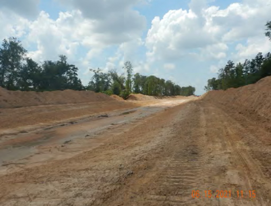
Bens Branch and Taylor Gully Cleanouts
In Kingwood, HCFCD finished excavating both Bens Branch and Taylor Gully to help restore their conveyance. Through gradual sediment built up, both had been gradually reduced to a 2-year level of service in places. That means they would come out of their banks after a 2-year rain.
Final phase of Bens Branch maintenance between Kingwood Drive and Rocky Woods. Note Kingwood High School in upper right.
GMA-14 will take a final vote on January 5 on the final DFCs. You still have time to protest.
Posted by Bob Rehak on 12/31/2021
1585 Days since Hurricane Harvey
https://i0.wp.com/reduceflooding.com/wp-content/uploads/2021/06/20210303-RJR_5778.jpg?fit=1200%2C800&ssl=18001200adminadmin2021-12-31 10:48:382021-12-31 11:09:51Top Stories of 2021 in Review
This morning, the Texas Commission on Environmental Quality (TCEQ), notified me that they again cited the controversial Colony Ridge development in Liberty County for lack of pollution controls.
On June 15, 2021, the investigator found active construction along Long Branch Creek. He noted that the slopes of the creek were not stabilized. He also found un-stabilized sediment piles along the banks of the creek, a damaged silt fence, and an unstabilized drainage channel. Additionally, the slopes of Long Branch Creek were also un-stabilized.
Continuing north intoSection 12, the investigator noted more un-stabilized sediment piles on the edges of un-stabilized drainage ditches connected to Long Branch Creek. The slopes of Long Branch Creek were also un-stabilized in Section 12. While documenting active land clearing, the investigator noted an unprotected tributary that flows into Tarkington Bayou.
After reviewing the site’s stormwater pollution prevention plan, the investigator determined that Section 12 did not have erosion control measures installed as prescribed.
TCEQ Investigation #1736609
The investigation confirmed lack of best management practices at the construction site. One alleged violation was issued: Failure to install minimum controls.
From Attachment 4, “Unstabilized slopes in Long Branch Creek. Unstabilized sediment piles on the banks of Long Branch Creek.”
More unstabilized slopes and unstabilized sediment piles leading to Long Branch Creek from Attachment 4.
As per the Construction General Permit (CGP), D. Burton Construction LLC was required to “design install and maintain effective erosion controls and sediment controls to minimize the discharge of pollutants” and to document compliance with the stormwater pollution prevention plan (SWPPP).
That part of the document takes up the first four pages.
Supporting Documentation
A series of attachments make up the the next 181 pages.
Attachment 1: Vicinity Map
Attachment 2: TCEQExit Interview sent on June 24, 2021
Attachment 3: Permit Information
Attachment 4: Investigation Photographs
Attachment 5: Photo Locations Map
Attachment 6: Flyover Photographs
Attachment 7: Records Request Sent on June 16, 2021
Attachment 8: Response to Records Request
Purpose of SWPPP and Control Measures
The primary purpose of erosion control is to protect surface waters. To do that, TCEQ says contractors should protect slopes and channels.
“Convey concentrated storm water runoff around the top of slopes and stabilize slopes as soon as possible. This can be accomplished using pipe slope drains or earthen berms or other flow controls that will convey runoff around the exposed slope.”
“Avoid disturbing natural channels and the vegetation along natural channels, if possible.”
TCEQ
The SWPPP also contains a lengthy discussion of erosion and sediment controls beginning on page 78. I recommend it for anyone who thinks he/she may be receiving eroded sediment from a construction site.
Soil Report Largely Consistent with Earlier Findings Showing Need for Detention Ponds
Starting on page 128, you can also read an extensive custom soil report from the USDA Natural Resource Conservation Service.
They suggest this area will have a high amount of runoff after development. Little water will sink into the soils. And that could increase downstream flooding, unless the developer installs sufficient detention pond capacity.
Colony Ridge is in Liberty County. But if Harris County guidelines applied, they call for .55 acre feet of detention capacity per acre (for developments greater than 640 acres). Thus, if the area under development is 1200 acres, that would call for 660 acre feet of detention ponds (or 100 acres – six and a half feet deep). I saw nothing that large during my last flyover at the end of May.
It’s not clear at this time whether the developer has improved his erosion-control measures. Two calls to the TCEQ have not yet been returned.
Posted by Bob Rehak on 9/3/2021 based on TCEQ Investigation #1736609
1466 Days since Hurricane Harvey
The thoughts expressed in this post represent opinions on matters of public concern and safety. They are protected by the First Amendment of the US Constitution and the Anti-SLAPP Statute of the Great State of Texas.
https://i0.wp.com/reduceflooding.com/wp-content/uploads/2021/09/20210903-Screen-Shot-2021-09-03-at-2.03.57-PM.jpg?fit=1200%2C912&ssl=19121200adminadmin2021-09-03 15:34:322021-09-03 16:04:38TCEQ Again Cites Colony Ridge for Lack of Pollution Controls
The month after Woodridge Village flooded Elm Grove Village and North Kingwood Forest for the first time in May, 2019, the TCEQ investigated construction practices there. In the ensuing months, six investigations found 13 violations on the Woodridge site.
Correctly identify receiving waters for the discharge
Implement and maintain effective best management practices.
On TCEQ Commissioners Docket for September 9
Item 29 on their docket reads:
No. 2019-1513-WQ-E. Consideration of an Agreed Order assessing administrative penalties and requiring certain actions of Double Oak Construction, Inc. in Montgomery County; RN110478583; for water quality violations pursuant to Tex. Water Code chs. 7 and 26 and the rules of the Texas Commission on Environmental Quality, including specifically 30 Tex. Admin. Code ch. 60.
Water samples taken by the investigators showed that at the outfall:
Total Suspended Solids were 70 times higher compared to upstream
Total Dissolved Solids were almost 18 times higher.
Double Oak had been hired to clear and grub the site. That means removing trees and roots.
Unchecked erosion from site polluted water downstream with suspended solids 70 times higher than upstream.Abel Vera had to grab his car to avoid slipping in ankle-deep sediment on Village Springs. Vera lives next to Woodridge.
Definition of Agreed Order
This enforcement action by the TCEQ falls into a category called an “Agreed Order.” A website called USLegal.com defines an agreed order as: “An Agreed Order refers to a written agreement submitted by the parties to a case resolving the issues between them. Once the agreed order is approved by the court and entered in its minutes, it becomes the order or decree of the court with all of the force and effect that any order would have after a full hearing prior to adjudication.”
However, they add: “…until then, an ‘agreed order’ is no order at all, but merely an agreement of the parties. It has no significance … until a judicial … decision gives it significance.” TCEQ Commissioners will take that step on September 9.
Double Oak Penalties Unclear
Documents supplied in response to a FOIA request did not discuss what the penalties might entail for Double Oak. The company left the construction site long ago. It has since been sold to Harris County Flood Control and the City of Houston for a regional stormwater detention basin and sewage treatment plant. So it’s not as if Double Oak can make good by simply agreeing to clean up its act.
Typically, such cases involve a modest fine. The significance in this case: Double Oak apparently is admitting wrongdoing before a decision or settlement has been reached in hundreds of homeowner lawsuits downstream. More on those at a later date.
1463 Days after Hurricane Harvey and 712 Days since Imelda
The thoughts expressed in this post represent opinions on matters of public concern and safety. They are protected by the First Amendment of the US Constitution and the Anti-SLAPP Statute of the Great State of Texas.
https://i0.wp.com/reduceflooding.com/wp-content/uploads/2019/05/ElmGroveFlood_15_01.jpg?fit=1500%2C1000&ssl=110001500adminadmin2021-08-31 19:24:382021-08-31 19:32:47TCEQ Commissioners to Consider Agreed Order With Double Oak Construction on Woodridge Village Enforcement Action
For those wishing to submit comments about sand-mining Best Management Practices (BMPs), but who may feel daunted by the complexity, I’ve compiled a list. If you use a computer-based email application, you should be able to submit it with one click.
It should address and title an email, then automatically insert the recommended text shown below. Don’t forget to insert your own contact information at the end of the email, before hitting the send button.
I have not tested the automated link with all email apps, browsers and platforms. So if you run into problems, just cut and paste the text between the separators below. Again, don’t forget to add your contact information.
Please share this with all your friends, family and neighbors. Ask them to submit the comments and share it, too.
Deadline: 8/19/21.
Dear TCEQ,
After reviewing the Draft Proposed BMPs for Sand Mining in the San Jacinto River Basin, I have several comments that I would like you to consider.
Geographic area should include “all tributaries draining into Lake Houston,” not a limited subset.
Include provision that steps up enforcement. Operators already routinely violate too many of these BMPs.
Introduction: Put the need for BMPs in perspective by including a sentence or two that talks about the $222 million spent by Federal, State, and Local governments to dredge the San Jacinto.
Introduction: Add this thought. “The presence of the Lake Conroe dam can lull operators on the West Fork into a false sense of security. During Harvey, Lake Conroe released 79,000 CFS. All by itself, that would have qualified as the ninth largest flood in West Fork history, even if not a drop of rain had fallen anywhere else in the watershed. Such high rates of conveyance lead to high rates of erosion and sediment transport that require operators to exercise extreme caution in this environment and closely follow the BMPs below.”
Introduction, include a sentence to this effect. “When deviating from standard BMPs, the operator must file documentation with the TCEQ which will be posted for public inspection and obtain written approval from the TCEQ.”
Introduction: In the bullet point after “Geographic Location,” replace “hydrogeology” with “Surface and groundwater hydrology.”
Introduction: After the sentence which ends with “…implemented by the sand mining operators,” Include the following. “All BMPs must be submitted to the Executive Director (ED) of the program for review and approval.”
2.1: Replace “next anticipated storm” with “must repair or replace controls immediately when damage is noted during weekly inspections.”
2.1.1: Define the 100-foot buffer zone as “…measured from the stream bank to the closest disturbed area…”
2.1.1: After “and 35 feet for intermittent streams” insert the following: “Wider buffer zones might be necessary where riverbank erosion rates are high.”
2.2: Change Site operators must “inspect disturbed areas” to “inspect and document disturbed areas.”
2.2: After “…All structural controls must be in compliance with local rules and permitting requirements,” add: “including special restrictions for construction in a FEMA-defined floodway.”
2.2: Require that operators inspect all structural controls “once every seven (7) calendar days.”
2.2.5: Specify that “operators must measure and document the depth of sediment basins at least once a year, as well as before and after major floods.”
2.2.5: Add: “Special consideration must be given to stability of the outer dike (or levee) separating the pits from the vegetated buffer zone adjacent to the river. Lateral erosion of the river can result in breaching of the dike and potentially rerouting the river through the pit area (pit capture).”
2.2.5: Specify what operators must do “prior to discharge” to have a “permitted” discharge.”
2.2.6: In the sentence that ends with “…will not erode the receiving stream,” add “…or adjacent properties.”
2.2.10: Detention ponds big enough to hold an inch of rain seem wholly inadequate in an area where Atlas-14 specifies 16.9 inches for a 100-year event. Harris County Flood Control District recommends minimum detention volumes for developments at .65 acre feet per acre. That’s about 8 inches of rainfall. Please modify required depth.
3.1: Specify that TCEQ must approve the mine plan.
3.1: Mention that building mines in floodways requires extreme precautions for virtually every facet of mining. (This section currently makes no mention of floodways, yet virtually all San Jacinto mines are at least partially built in floodways.)
3.1: Replace the sentence that starts with “An evaluation of…” with “The susceptibility for erosion of on-site soils and lateral erosion rates of adjacent rivers must also be known in the pre-planning stages. If parts of the proposed mine are located in a FEMA-defined floodway, hydrologic and hydraulic analyses performed in accordance with standard engineering practice must demonstrate that the proposed encroachment will not result in any increase in flood levels or erosion of upstream, downstream, or adjacent properties.”
3.2.1: After the sentence that ends with “…other than TCEQ hold jurisdiction,” replace the next sentence with “Additional erosion controls or increased buffer widths may be needed where river erosion rates are high, receiving streams are listed in the Clean Water Act (CWA) 303(d), or critical facilities (e.g. bridges, pipeline or utility corridors) are adjacent to the proposed operation.”
3.2.1: Complete the sentence that starts with “Understanding site drainage can be obtained by using…” with “existing LiDAR and aerial photo images.” Delete the part about USGS Topographic maps which show a series of contour lines. Then modify the next sentence in that paragraph to read, “These images (combined with lower resolution USGS topographic maps) can be used to determine slope of the ground surface through the site to identify drainage patterns.”
3.2.2: After the sentence that ends with “…water supply wells are located nearby,” add this sentence: “If present, waste management units must be located a minimum horizontal distance from adjacent water wells, in accordance with 16 Texas Administrative Code Chapter 76.”
3.3: Say “Topsoil material MUST be temporarily stockpiled for future use in post-mining activities.”
3.3: Add this thought. “Stockpiles may not be located in floodways.”
3.3.2: After, “…diverting upslope water around a planned area for disturbance is also good practice,” add “however, care must be taken to not have the diverted water result in increased downslope flooding.”
3.3.3: Change the sentence that starts with “Stockpile protection is most effective when…”, so that it reads, “Stockpile protection is most effective when stockpiles are not located on the FEMA-defined floodway, are located away from concentrated flows of storm water, drainage courses, and inlets, and when are properly protected with perimeter sediment barriers and covered.”
3.3.3: After the sentence that ends with “…geoscientists certifying BMPs at the site,” add another sentence that reads, “Additional buffer width or structures may be required where critical structures such as pipeline or utility corridors are located.”
4.1: Add: “Operators should not dredge a vertical wall at the edge of buffer zones. This can lead to cave ins at the edges that decrease the width of the buffer zones. It may also not leave enough room to taper slopes enough to plant vegetation in the post-mining phase.”
4.5: Add “All fuel storage tanks must be located outside of floodways.”
4.5: Add “New floodplain and floodway maps for the San Jacinto region should be released sometime in 2022 or 2023. Floodways are expected to expand by approximately 50%. Take this into account when planning placement of storage tanks.”
4.5: Add “Remove all fuel storage equipment and tanks before abandoning a mine.”
4.6: Add new section that includes this thought.
5: Change the first sentence in the introduction to say, “The Post-Mining Phase stabilization plan must be approved by TCEQ, subject to input from the landowner and downstream property owners.”
5.1: Change “may” to “must” in the second sentence and delete several subsequent words so that it reads, “The following guidelines MUST be used to meet site stabilization objectives.”
6: Replace the entire introduction with the following: “Prior to operations beginning at a sand mining facility site or portion(s) of the site, an initial stabilization report must be submitted to the executive director for review and approval at (Address). The Initial Stabilization Report must, at a minimum, include and demonstrate that the items described below in section 6.1 Report Requirements will be addressed. This initial report will be updated annually to reflect current mobilization and reclamation areas.”
6.1: Add: “After completion of mining, remove all vehicles and debris that could be swept downstream in a flood.”
6.1: Under Structural Controls, after the sentence that ends with “…manage remaining onsite drainage,” add another sentence. “This includes making sure the outer dike (or levee) that separates the abandoned pits from the adjacent river is not breached due to lateral erosion of the river.”
6.1: Under High Walls, after “The permittee shall demonstrate that all remaining highwalls are stable and safe,” add the following. “This may mean leaving enough buffer between adjoining properties to taper slopes to a gradient that will allow the planing of vegetative controls that prevent erosion.”
6.1: Add: “Conservation easements on buffer areas, placed before mining, could be utilized to ensure community protection. Conservation easements placed post-reclamation would ensure that site ecology would be monitored, and restoration activities completed. An accredited land trust involved as a conservation partner would provide third-party documentation of adherence to the ecological practices outlined in these guidelines and provide community oversight that is currently missing.”
Glossary: Add “Floodway (Regulatory Floodway) – the channel of a river or other watercourse and the adjacent land areas that must be reserved in order to discharge the base flood without cumulatively increasing the water surface elevation more than a designated height.”
If you would like to provide your own public comments, email Macayla.Coleman@Tceq.Texas.gov with the subject line “BMPs Guidance Document” by the close of business tomorrow.
This company lost property (red circles) when a sand mine left highwalls around it that collapsed into the pit.Photograph of same areas taken on 8/17/2021.
Each of the recommendations above has a story behind it like these pictures tell. Please help by submitting public comments.
Posted by Bob Rehak on 8/19/2021
1451 Days since Hurricane Harvey
The thoughts expressed in this post represent opinions on matters of public concern and safety. They are protected by the First Amendment of the US Constitution and the Anti-SLAPP Statute of the Great State of Texas.
https://i0.wp.com/reduceflooding.com/wp-content/uploads/2021/08/20210817-DJI_0356.jpg?fit=1200%2C799&ssl=17991200adminadmin2021-08-18 20:03:342021-08-18 22:19:10One-Click Submittal for Suggested Public Comments on Proposed Sand-Mining BMPs
This is the eighth in a series about Best Management Practices (BMPs) proposed by the Texas Commission on Environmental Quality (TCEQ) for sand mines in the San Jacinto watershed. This post will focus on the Final Stabilization Report that operators should file after mines cease operation.
As we saw yesterday, operators abandon many mines with little thought to stabilization, cleanup, or reclamation. When that happens, mines become a blight on communities and the environment.
Below is the text of proposed BMPs for the Final Stabilization Report. I will provide my comments at the end. Here is a link to the complete text of all BMPs proposed by the TCEQ.
Final Stabilization Report
BMPs within the final stabilization report show what the TCEQ values. One made me scratch my head and sigh “Huh?” Others represent glaring omissions. Below, see the proposed text.
6 Final Stabilization Report
Prior to operations terminating at a sand mining facility site or portion(s) of the site, a final stabilization report must be submitted to the executive director for review and approval at the following address:
Texas Commission on Environmental Quality Stormwater Team Leader (MC-148)
P.O. Box 13087
Austin, Texas 78711-3087
The Final Stabilization Report must, at a minimum, include and demonstrate that the items described below in section 6.1 Report Requirements have been addressed.
6.1 Report Requirements
Vegetative Cover:
The operator shall establish perennial vegetative cover in all areas except where ponds, highwalls, permanent structures, or paved areas exist.
Perennial vegetative cover must be uniform (i.e. evenly distributed with no large bare areas) and have a density of at least 70 percent of the native background vegetative cover for the area.
Vehicle and Equipment Storage and Maintenance Areas:
The operator shall remove fluids and batteries from, and thoroughly clean all vehicles and equipment remaining on-site.
All fuel and chemicals must be removed from maintenance areas. Maintenance areas must be thoroughly cleaned and cleared. If maintenance areas are unpaved, these areas must have vegetative cover established.
Structural Controls:
All temporary structural controls must be removed from the site. Remaining permanent structural controls must be adequate to manage remaining on-site drainage.
Other:
Highwalls: The permittee shall demonstrate that all remaining highwalls are stable and safe.
Waste: All waste must be removed from the site and disposed in accordance with applicable TCEQ rules.
Landowner Agreement: If applicable, a copy of all existing agreements with landowners regarding stabilization of the site must be included.
Certification: The Final Stabilization Report must be signed and certified by a Texas licensed professional engineer or a Texas licensed professional geoscientist.
Comments
I have several comments on these.
The first has to do with vehicles and equipment “remaining” onsite. The BMP only requires that the operator must “thoroughly clean all vehicles and equipment remaining on site”! Really? Why not require removal?
This BMP lets operators turn old mines (and our river system) into junk yards. It’s a recipe for urban decay. Rivers flood periodically and will inundate the old equipment and abandoned vehicles. Simply cleaning it before it floods and rusts is a joke.
If operators don’t want the equipment and vehicles they should sell them to another operator or for scrap, not just clean them. Don’t turn them into a blight on the landscape or communities.
Sand mining equipment abandoned for years between downtown Humble and the West Fork.One operator’s idea of cleaning an excavator before abandoning it. This pit is now open to the river through erosion.
Second, the Final Stabilization report BMPs make no mention of removing debris.
Give me a home…where the deer and the antelope roam!Abandoned West Fork Mine.
Third, nor do they mention removing old buildings which could attract squatters and drug users.
Abandoned East Fork Mine with rusting buildings still on site.
Fourth, they make no mention of ensuring that outer dikes (or levees) separating abandoned pits from adjacent rivers are not breached due to lateral erosion of the river.
Abandoned mine after Harvey on right, West Fork on left.Same area today. Lateral erosion breached dike allowing sediment to escape.
Finally, as with the BMPs in previously covered sections, enforcement is an issue here, too.
So where’s the vegetative cover?The high wall of this pit has partially collapsed endangering properties around it and people standing near it. The wall was not properly stabilized.
Public Comments Due by 7/19/21
Please submit your thoughts on the Final Stabilization Report and other BMPs to the TCEQ. Email Macayla.Coleman@Tceq.Texas.gov with the subject line “BMPs Guidance Document” before August 19, 2021.
Posted by Bob Rehak on 8/17/2021
1449 Days since Hurricane Harvey
The thoughts expressed in this post represent opinions on matters of public concern and safety. They are protected by the First Amendment of the US Constitution and the Anti-SLAPP Statute of the Great State of Texas.
https://i0.wp.com/reduceflooding.com/wp-content/uploads/2021/08/20210101-RJR_4113.jpg?fit=1200%2C800&ssl=18001200adminadmin2021-08-17 13:14:112021-08-17 13:20:34BMPs for Final Stabilization Report Omit Crucial Elements