On August 20, 2021, four-years after Harvey inundated Humble/Kingwood and 20 months after the City of Houston started dredging the San Jacinto West Fork mouth bar, the City finally posted a request for qualifications to develop a long-range dredging plan for the Lake Houston Area.
The plan will cover the entire Lake Houston Area including: publicly owned canals, inlets, and coves; the West Fork up to I-69, and the East Fork to the confluence with Caney Creek. The City wants the plan finished within two years.
Plan Scope
Scope of the long-range dredging plan includes:
Developing a digital terrain model that updates Texas Water Development Board models developed in 2011 and 2018 to reflect dredging activity that has taken place since then.
Verifying where and how quickly sediment accumulates.
Determining ownership of private canals and legal obstacles associated with dredging them.
Identifying disposal sites for the dredging spoils.
Investigating costs for both mechanical and hydraulic dredging through both private and public entities.
Exploring options for future funding of maintenance dredging.
Evaluation Criteria
Firms will be evaluated on:
Responsiveness of their submissions to the criteria outlined.
Technical competence, which is a composite of:
Firm Qualifications
Expertise, experience and qualifications of key personnel
Project approach to meeting deliverables, managing risk, and managing work
Proposed plan and strategy for meeting project schedules
Success with similar projects in the past
Participation by Minority/Women-Owned Business Enterprises
Since my last update three weeks ago, dredgers has moved into the channel south of Royal Shores that connects the East and West Forks of the San Jacinto.
Dredgers have finally entered the channel between the West and East Forks of the San Jacinto on their way to the East Fork. Photo taken 8/28/2021Since my last update on August 6, 2021, the dredging has moved another 600 feet into the channel connecting the East and West Forks south of Royal Shores.
Four Years Ago Tonight
The current rate of dredging is consistent with the rate observed on August 6, about 200 feet per week. At this rate, it will take another two months until contractors even reach the East Fork. And at least another two years before we get a long-range dredging plan. That will be six years after Harvey.
https://i0.wp.com/reduceflooding.com/wp-content/uploads/2021/08/20210828-DJI_0427.jpg?fit=1200%2C799&ssl=17991200adminadmin2021-08-28 17:21:222021-09-23 15:54:57City of Houston Posts Request for Qualifications to Develop Long-Range Dredging Plan
Below is a quick digest of six flood-related stories affecting the Lake Houston Area.
Dredging is a Slow Go
Mechanical dredgers are slowly working their way through the channel south of Royal Shores. It connects the East and West Forks of the San Jacinto. Without dredging, the dredging equipment itself would not be able to make it through the channel.
However, the pace of the dredging is painfully slow. You can see the progress by comparing the two pictures below. I took them 22 days apart.
Taken on July 11, 2021Taken on August 2, 2021. Google Earth shows they went a little more than 600 feet in a little more than three weeks.
At about 200 feet per week with about 2,000 more feet to go, they should reach the East Fork in about another ten weeks.
Several boaters have commented on how the dredges can wait hours for a pontoon to ferry dirt back to the placement site. Their net takeaway: very inefficient. During a July 8 meeting at the Kingwood Community Center, Stephen Costello called this method of dredging “unsustainable.” He’s sooooo right. We will run out of luck long before we run out of places to dredge.
Mechanical dredging (shown in the photos above) is far slower and less efficient than hydraulic. Great Lakes hydraulic dredges removed 500,000 cubic yards of sediment from the mouth bar area in just two months – July and August of 2019. DRC’s mechanical dredges removed another 600,000+ cubic yards in the 19 months between January 2020 and July 2021.
Interestingly, Google Earth shows that when the dredgers reach the East Fork, they will be closer to the Triple PG Sand Mine in Porter than the current placement area south of River Grove Park. The Triple PG mine will also be less than half the distance of a mine that the Army Corps previously pumped spoils to from the mouth bar– the Eagle Sorters Mine on the West Fork.
Hmmmm. Triple PG. A placement area for East Fork spoils? A return to hydraulic dredging? Interesting thoughts.
Seasonal Lowering of Lake Conroe
Seasonal lowering of Lake Conroe has started as planned. SJRA is releasing 75 cubic feet per second, according to their dashboard.
Seasonal release is shown as a City of Houston (COH) Diversion.
When the lowering started on August 2, a day late, the lake was at 200.87. So releasing 75 CFS has brought the lake down .19 feet, a little more than 2 inches. Barring large rainfalls, this rate should reach the objective of 200 feet by September 1.
The National Hurricane Center shows two areas of concern in the Atlantic as of 2PM, Friday August 6th.
A few hundred miles south of the Cabo Verde Islands, a tropical wave (orange area) and a broad area of low pressure could turn into a tropical depression by late this weekend or early next week. Formation chance through 5 days…medium…60 percent.
Another tropical wave approaching the Lesser Antilles is a lower threat. NHC predicts development, if any, of this system will be slow and occur early next week. Formation chance through 5 days…low…20 percent.
NOAA Issues Mid-Season Hurricane Outlook
Another forecast released two days ago by NOAA says that atmospheric conditions are still conducive for an above-average hurricane season. See their predictions in the right hand column below. These numbers include the five named storms so far this season.
Attorney General Lawsuit Against Triple PG Mine Still Active
Craig Pritzlaff of the TCEQ assures me that despite visible lack of progress in the Attorney General’s lawsuit against the Triple PG mine for illegal discharges, the AG has not dropped the case. “Indeed, very few, if any, cases referred to the AG for civil prosecution are ever dropped,” he says. “Litigation, particularly environmental litigation, is a complicated and lengthy process. That process was further complicated by the COVID-19 pandemic, which halted court dockets across the State throughout 2020 and into 2021.”
Condos 250 Feet from 250,000 CFS
A Chinese developer is building yet more condos even closer to the West Fork in the Kings Harbor neighborhood.
See new construction bottom center. Lai finished the units at the right earlier this year. The nearest unit above will be about 250 feet from the San Jacinto West Fork.
During Harvey, more than 250,000 cubic feet per second came through this area. It flooded homes and businesses more than 10,000 feet from the river.
The thoughts expressed in this post represent opinions on matters of public concern and safety. They are protected by the First Amendment of the US Constitution and the Anti-SLAPP Statute of the Great State of Texas.
https://i0.wp.com/reduceflooding.com/wp-content/uploads/2021/08/20210802-DJI_0286.jpg?fit=1200%2C799&ssl=17991200adminadmin2021-08-06 16:46:402021-08-07 19:38:36Digest: Updates on Six Lake Houston Area Flood-Related Stories
On Thursday last week, Stephen Costello, PE, the City of Houston’s Chief Recovery Officer, gave an update on Lake Houston dredging. Costello said that mechanical dredging was starting to move from the West Fork to the East Fork of the San Jacinto River.
Next Phase of Dredging Starting
This marks the beginning of the next phase in dredging after Harvey. Since 2018, dredgers have focused on the West Fork, which was 90% blocked by sediment in places, according to the Army Corps. The Corps and the City removed 2.9 million cubic yards of sediment from the West Fork. Now the focus will migrate to the East Fork, and then Lake Houston itself.
But to get to the East Fork mouth bar, dredgers must first deepen the channel south of Royal Shores that connects the two forks…or else take the long way around to the placement area.
Yellow dot represents most recent focus of dredging on West Fork. The dotted line branching off to the right through the channel is how dredger’s will get back and forth to the East Fork Mouth Bar (big yellow circle) and the placement area south of River Grove Park on the West Fork.
Channel Filled with Silt, Too
Costello said silt in the channel made it too shallow for pontoons and equipment to navigate back and forth safely.
Photos taken this afternoon show that the first equipment is starting to dredge the channel inside two ancient cutoff meanders of the West Fork.
Looking west toward West Lake Houston Parkway Bridge from over the channel connecting the West and East Forks.Wider shot from farther back shows the dredge area within the cutoff meanders.Looking East toward the East Fork and Luce Bayou (upper right).
As the last photo shows, at this time, no dredging activity has yet reached the East Fork.
Boaters: Exercise Caution Around Dredging Equipment
This cut-through is a popular shortcut for boaters. Boaters may wish to take the long way around for the next few months or, at a minimum, use extra caution. Those excavators have long arms and can turn suddenly. Remember: operators don’t have eyes in the backs of their heads. Make sure they acknowledge your presence before zipping past them.
Posted by Bob Rehak on 7/11/2021
1412 Days since Hurricane Harvey
https://i0.wp.com/reduceflooding.com/wp-content/uploads/2021/07/20210711-DJI_0062.jpg?fit=1200%2C799&ssl=17991200adminadmin2021-07-11 17:40:332021-07-11 17:40:38Lake Houston Dredging Starts Moving to East Fork
At one of the first large public meetings since Covid began, several hundred people crowded into the Kingwood Community Center last night. They came to see the City unveil floodgate and dredging plans for Lake Houston. Stephen Costello, PE, the City’s Chief Recovery Officer, addressed dredging. And Chris Mueller, PhD, PE, of engineering firm Black & Veatch discussed adding more floodgates to the Lake Houston Dam. Mayor Pro Tem Dave Martin coordinated the meeting.
In late 2019, the Army Corps finished hydraulic dredging in the area south of the West Fork mouth bar. Then in early 2020, the City of Houston began mechanical dredging to extend the effort. In terms of the estimated dollars designated for dredging, the effort is about halfway done.
The first four rows on this chart are done or almost done. They total $114 million out of a projected total of $222 million.
Scope of Long-Range Dredging Plan Still in Development
A long-range dredging plan for Lake Houston is critical. We must understand where the sediment comes from, how fast it builds up, where it builds up, and the consequences of not removing it periodically.
The numbered dots in the photo above show channels south of the East and West Forks draining into Lake Houston where sediment can also build up.
Costello says the City is currently working with affected homeowner associations to discuss cost-sharing arrangements.
He also says that the City must identify a long-range site for depositing the spoils that is suitable for hydraulic dredging. He called the mechanical dredging now in progress “not sustainable.” Currently, the City is using Berry Madden’s property on the West Fork south of Kingwood’s River Grove Park to deposit the mechanical dredging spoils. That’s a long haul for barges on the East Fork.
Next Dredging Steps: Channel to East Fork and East Fork Itself
Contractors must next deepen the channel between the West and East Forks of the San Jacinto to move dredging equipment and spoils back and forth (see below).
Current location of dredging is near yellow dot.
From there, dredgers will move slightly north of where Luce Bayou (far right) enters the East Fork and begin dredging the East Fork mouth bar. See large circle above. The map shows that area grew shallower by up to nine feet between 2011 and 2018. Imelda, in September 2019, made it grow even shallower. Note the fresh deposits of sand in the photo below now poking up above the water.
Growth of East Fork Mouth Bar after Imelda in September 2019. Photo taken in November 2019.
Additional Floodgates for Lake Houston Dam
Chris Mueller of Black & Veatch then discussed the reasons for adding additional floodgates to Lake Houston, preliminary engineering findings, and an implementation schedule.
The primary objective: to increase the outflow capacity of the dam to reduce the risk of future flooding. However, he emphasized that reducing the risk for people upstream of the dam cannot have an adverse impact on people below it. See below.
He emphasized that Lake Houston is, first and foremost, a drinking water reservoir. He also emphasized that the dam is almost seventy years old and near the end of its useful life. Significant safety issues exist in working with such old concrete.
Calculating the Benefit/Cost Ratio of Additional Floodgates
Mueller then explained how FEMA calculates the benefit/cost ratio of additional floodgates.
On the benefit side, it considers: the reduction in water surface level; how many buildings and streets that will prevent from flooding; reduced societal impacts; and reduced impacts to business revenues. These are primarily damage costs avoided.
On the cost side of the equation, FEMA factors in construction costs and annual operation and maintenance costs.
To win project approval, the City must show that the benefits of additional floodgates exceed the costs in a 100-year storm, similar to Imelda. Such a storm elevates the lake 10 feet.
The peak inflow to Lake Houston in a 100-year storm: 286,000 cubic feet per second (CFS), enough to fill the Astrodome in 3 minutes! However, during Harvey, SJRA estimated the peak inflow at 400,000 cfs.
Proposed Alternative Produces 11-Inch Benefit Nearest Dam
A hydrologic and hydraulic analysis conducted by Black & Veatch will help prove up the benefit/cost analysis. The San Jacinto Watershed (including Buffalo Bayou) includes flow from eight counties.
In evaluating about ten alternatives for adding floodgates, Black & Veatch considered both cost and non-cost factors listed below.
The company’s first choice was to install additional gates on the earthen portion of the dam on the east side. But environmental considerations there would have delayed the project by a decade or more.
So they decided to recommend a 1,000 feet of crest gates on the west side of the spillway instead. See example of crest gates in operation below.
An air bladder near a bottom hinge raises or lowers the floodgatesto let water in/out
Such gates would increase the discharge capacity to 45,000 cfs, more than four times the current capacity of 10,000 cfs. That’s still only about a third of the discharge capacity of the floodgates on Lake Conroe. But according to Martin, that would still be enough to lower the level of the lake 4 feet in 24 hours.
However, before floodgate construction can begin, engineers must evaluate:
Downstream impacts and how to mitigate them
Impact to the stability of the existing concrete dam
Back in the 1950s when the Lake Houston dam was built, engineers did not use rebar. So this will be a delicate operation. Contractors must cut 6 feet into the existing spillway; cap the remaining concrete with a slab; and install the crest gates on top of the slab.
Black & Veatch must also develop an operations protocol for new floodgates that maximizes upstream benefits and limits downstream impacts. Mueller shared this schedule with attendees.
Best-Case Project Timeline Shows Completion in 2024
Schedule as of 7/8/2021.Detailed engineering could take another year.
A best-case scenario shows construction starting at the end of 2022 and finishing before the start of hurricane season in 2024. So, at least three more hurricane seasons to get through before seeing any benefit from additional gates.
State Representative Dan Huberty filed HB2525 on March 1, 2021 to create a dredging district to perform ongoing maintenance dredging on Lake Houston. However, the boundaries of the District will be the boundaries of Harris County. As of March 2, Huberty’s bill does not yet have a senate sponsor, nor has it yet been referred to a committee.
Need for Maintenance Dredging Recognized Decades Ago
Back in 2000, the Brown & Root Report, which came out of the 1994 flood, recommending maintenance dredging to prevent the kind of sediment buildups that contributed to Harvey flooding. But nothing was ever done until after thousands of homes and businesses flooded during Harvey.
Meanwhile, more sediment comes downstream with each flood. And that 2019 money won’t last forever. So ever since the last legislative session, Huberty has sought a permanent solution.
Create a special purpose dredging and maintenance district whose operations are limited to Harris County and Lake Houston (including East Fork, West Fork and mouths of tributaries such as Rogers Gully, Luce Bayou and Ben’s Branch.
Maintenance will consist of the removal of floating debris, such as trees that clogged the waterways after Harvey.
The district will be governed by a board of seven.
Harris County Commissioners will appoint three directors.
Houston City Council will appoint three.
The County Judge and Mayor will jointly name the board’s presiding officer.
The District may:
Form interlocal agreements with other political subdivisions and corporate entities or persons to perform the work.
Seek grants of money, equipment or other resources to assist in its operations.
It may not:
Finance, develop or maintain a recreational facility.
Exercise eminent domain.
Perform the same functions as an overlapping conservation or reclamation district.
Financial Provisions
In addition to raising money from grants, HB2525 gives the District power to issue revenue bonds, but it may NOT levy a tax.
In formulating this bill, financing District operations received considerable discussion. Casey Christman, Huberty’s assistant, said, “We will have a committee substitute on this bill that makes several changes. But this bill would let the Lake Houston Dredging and Maintenance District (LHDMD) create individual interlocal agreements with each entity that purchases water, which at last count was about 68 organizations.”
“The terms of each agreement may differ (i.e. commercial vs. residential) but will outline how and where the fees are assessed. Also, LHDMD would be eligible to apply for grants or funds from other governmental entities, like FEMA or TWDB. Lastly, the new language will permit LHDMD to sell any materials collected. All options could help pay down bonds,” said Christman.
Thanks to Representative Dan Huberty for his persistence and leadership on this issue.
Posted by Bob Rehak on 3/2/2021
1281 Days since Hurricane Harvey
https://i0.wp.com/reduceflooding.com/wp-content/uploads/2021/03/20210228-DJI_0253.jpg?fit=1200%2C900&ssl=19001200adminadmin2021-03-02 18:41:152021-03-02 18:42:33Huberty Files HB2525 to Create Lake Houston Dredging and Maintenance District
From construction developments to political developments, here’s your January digest of ten stories that could affect flooding or flood mitigation in the Lake Houston Area.
1. New Caney ISD High School #3
This site is located between Sorters-McClellan Road and US59 south of the HCA Kingwood Medical Center. New Caney ISD is building a new high school on the site of the old par 3 golf course behind the car dealerships that front US59. Construction crews are still pouring concrete for foundations and parking lots. Not much happened between flyovers on December 7 and January 1. But then, not much happens anywhere during the holidays. The two photos below show the progress. Construction of the detention pond is nearing completion. However, contractors still need to plant grass to reduce erosion before spring rains arrive.
New Caney ISD High School #3 site as of December 7, 2020As of January 1, 2021.
Now, the development is back on the planning commission agenda for this Thursday. Holley is seeking approval of his latest General Plan and Plat. Neither show any detention ponds. The only place they could go would be in “Reserve C.” The General Plan shows that to be in the floodway and 100-year floodplain. Both could soon expand.
The West Fork floodway cuts through the southern part of Holley’s property.
The City raised an issue regarding compliance with regulations governing the re-plat of golf courses at the 12/17/2020 Planning Commission meeting. The City requested information relating to Local Government Code 212.0155.
That regulation requires, among other things, that:
Public notice of the re-plat be printed in newspapers
The Forest Cove Property Owners Association is notified
Residents have an opportunity to voice their opinions at public hearings
Owners of all properties within 200 feet of the new plat be notified in writing via US Mail.
If 20% of the owners object, the re-plat must win the approval of 3/5ths of the planning commission.
The developer proves there is adequate existing or planned infrastructure to support the new development.
The new subdivision will not adversely affect health, safety traffic, parking, drainage, water, sewer, or other utilities
The development will not have a materially adverse effect on existing single-family property values.
The new plat complies with all applicable land-use regulations and restrictive covenants and the City’s land-use policies.
That’s a lot to do over the holidays. So the general plan may need to be withdrawn and resubmitted after all the information has been produced. We should know more by Wednesday afternoon.
3. Dredging
Mayor Pro Tem Dave Martin’s January newsletter stated that Disaster Recover Corporation has removed 385,000 cubic yards from the West Fork Mouth Bar out of an estimated total of 400,000 cubic yards.
Then he alluded to dredging another 260,000 cubic yards from the area north of the mouth bar.
He also alluded to a Second Phase: dredging the San Jacinto East Fork and other locations in Lake Houston.
Finally, Martin discussed maintenance dredging. “Additionally,” he says, “during Phase Two of the project, City of Houston, Harris County, HCFCD, SJRA, and Coastal Water Authority (CWA) will develop and execute a plan for the City of Houston or CWA to assume long-term dredging operations on Lake Houston. This effort will include determining funding for dredging operations in perpetuity.”
4. Appointments to SJRA Board
Governor Greg Abbott has appointed Wil Faubel and Rick Mora, M.D. and reappointed Kaaren Cambio to the San Jacinto River Authority Board of Directors. Their terms will expire on October 16, 2025.
Kaaren Cambio of Kingwood is a field representative for United States Congressman Dan Crenshaw. She is a former member of Women’s Business Enterprise National Investment Recovery Association, Pipeline Contractors Association, and the Houston Pipeliners Association. Cambio received a Bachelor of Business Administration from San Diego State University.
Wil Faubel of Montgomery is President of Borets US Inc. He is a veteran and senior executive in the Oilfield Services industry with more than forty years of service. He has both domestic and international experience and is a lifelong member of the Society of Petroleum Engineers and a former board member of the Petroleum Equipment Suppliers Association. Faubel received a Bachelor of Science in Mechanical Engineering from Southern Methodist University.
Rick Mora, M.D. of The Woodlands is a partner at US Anesthesia Partners and Chief of Anesthesiology for Memorial Hermann Pinecoft Surgery Center. He has served as chair of the Montgomery County Hispanic Chamber of Commerce and is a founding Board member of the non-profit, Los Doctores de The Woodlands. Mora received his MD from the University Of Illinois College Of Medicine.
5. Forest Cove Townhome Buyouts
Harris County Commissioner’s Court will vote today on an item to exercise eminent domain on seven townhomes in the Forest Cove complex. The entire complex was destroyed after Harvey and many owners simply walked away from their properties without leaving forwarding addresses. Flood Control has been unable to find the owners after years of trying. Several may have moved out of the country. Eminent domain on these last few properties will clear the way for demolition of the entire complex and restoration of the area to nature or park land.
The once proud and idyllic townhomes in Forest Cove next to West Fork.
6. Woodridge Village
The purchase of Woodridge Village from Perry Homes is not on today’s Commissioner’s Court Agenda. However, all energies are reportedly still positive. It’s just taking time to work out the complex three-way purchase arrangements.
7. Romerica
Houston PlatTracker shows that the Romerica people may have acquired more land. But so far, they have not returned to the planning commission for approval on the latest iteration of the developer’s plans. No news is good news in this case.
8. Lake Houston Spillway Improvement Project
The City is close to finalizing the Preliminary Engineering Plan. Sources say the benefit/cost ratio looks very positive. We may see the final recommendations this month.
Engineers have examined several alternatives to add more gates to the Lake Houston dam or to increase its spillway capacity.
9. Noxxe Cleanup
The Railroad Commission could start plugging wells, removing storage tanks, and cleaning up the abandoned Noxxe lease in Forest Cove soon. The project manager has submitted work orders for final approval.
Small part of Noxxe lease next to Forest Cove baseball fields.
See new concrete pads (left center) and new construction (right foreground).
Posted by Bob Rehak on 1/5/2020
1125 Days after Hurricane Harvey
The thoughts expressed in this post represent opinions on matters of public concern and safety. They are protected by the First Amendment of the US Constitution and the Anti-SLAPP Statute of the Great State of Texas.
https://i0.wp.com/reduceflooding.com/wp-content/uploads/2021/01/Screen-Shot-2021-01-05-at-1.44.19-PM.png?fit=1266%2C1054&ssl=110541266adminadmin2021-01-05 13:35:232021-01-05 13:51:37January Digest of Flood-Related News in Lake Houston Area
Two world-class geologists, Tim Garfield and R.D. Kissling, both of whom live in the Lake Houston Area, agreed (at ReduceFlooding.com’s request) to offer their opinions on what would be the best strategy for dredging near the San Jacinto West Fork Mouth Bar. Garfield and Kissling helped bring mouth bar issues to the attention of the public after Harvey. Both have followed various dredging programs in that area closely ever since.
Looking west across the mouth bar on 9/11/2020 while hovering over Kings Point. Suspended sediment shows that main current of river is between remainder of the above-water portion of the mouth bar and Atascocita Point on the upper left.Photo taken 9/11/2020.
However, none of the various parties involved has volunteered to share their thinking about objectives and strategies behind mouth bar dredging alternatives. That’s why I asked Garfield and Kissling to offer their thoughts on what constituted the best strategy. Both worked for one of the world’s largest oil companies at the very highest levels.
Old Bathymetric Maps No Longer Valid
The first thing they realized was that they didn’t have enough data to make informed recommendations. The last published bathymetric maps were based on surveys taken before Imelda and before the Corps’ mouth-bar dredging.
Gathering Own Data
So Garfield and Kissling gathered their own data – with sonic depth finders, GPS, and a 14-foot pole with depth markings. They started upstream of the mouth bar, where the Army Corps finished its Emergency West Fork Dredging program near Kings Harbor. And they worked their way downstream beyond FM1960 to the railroad bridge.
Scope of Garfield/Kissling survey
Found Underwater Plateau 20′ High and 3 Miles Long
They found an underwater wall approximately 20′ high where the Corps stopped its first dredging program near Kings Harbor. It extended downstream more than 3 miles.
Cross section of river channel shows a rise of almost 20 feet wall on the upstream side of the mouth bar near Kings Harbor and an even greater drop near FM1960. The result: a 3-mile long underwater plateau.
That wall, they say, “…constitutes a significant and abrupt hydraulic barrier that will likely exacerbate flooding and sedimentation.”
That wall is the leading edge of a 3-mile-long underwater plateau.
Garfield and Kissling recommend dredging along the deepest path (see below). They reason that would save money.
Recommended and alternate routes identified by Garfield and Kisslingthat take advantage of deeper water.
“This might not only be the most beneficial dredging plan, but could also be the most cost effective as it leverages the paleo-channel as much as possible,” they say. “It harnesses nature, rather than fighting it.”
The geologists also identified a second possible route farther to the east but still south of the above-water portion of the stream mouth bar (labeled SMB in diagram above).
They caution that hydraulic modeling should be used to decide the best dredging plan. Political considerations drove initial mouth bar dredging rather than data. The Corps was authorized only to dredge an amount that it believed Harvey deposited. “We should be past the politics at this point and looking to get the most bang for our bucks,” say the geologists.
Whichever strategy the City settles on, Garfield and Kissling recommend excavating a channel, not a broad area, to get the best results for the dollars invested.
Objective: Re-establish Full Channel From Kings Harbor to Lake Houston
“This new channel should be no shallower, nor narrower than the upstream dredged channel at its end dredge location (450’ wide x 26’ deep),” say the geologists.
As a minimum, the future dredging plan should re-establish a continuous and down-stream deepening channel volume from where the Corps channel dredging ended to the 1960 bridge.
Tim Garfield and RD Kissling
This will help reduce sediment build up upstream from the plateau. By accelerating water through the blockage, it will let the river carry sediment farther out into the deeper portion of the lake. It will also reduce water backup that contributes to flooding.
Recommendations Consistent With City’s Preliminary Findings
The City has been methodically surveying Lake Houston and is in the process of developing its own maps, objectives and strategies. Stephen Costello, the City’s flood czar said they are not finished with that effort yet. However, he also said that the preliminary information they obtained suggested that a route south of the mouth bar might be the most effective.
Posted by Bob Rehak on 9/25/2020 with thanks to Tim Garfield and RD Kissling
1123 Days after Hurricane Harvey
https://i0.wp.com/reduceflooding.com/wp-content/uploads/2020/09/Slide6-1.jpeg?fit=1200%2C900&ssl=19001200adminadmin2020-09-25 12:33:102020-09-25 23:08:43Two Top Geologists Suggest Mouth Bar Dredging Strategy
Houston Mayor Pro Tem Dave Martin announced today that FEMA will fund the dredging of an additional million cubic yards of sediment from the area around the San Jacinto West Fork Mouth Bar. The giant sand bar partially blocked the mouth of the West Fork during Harvey and backed water up. It contributed to the flooding of thousands of homes and businesses in Kingwood, Humble and Atascocita.
Only a skeleton of the above-water portion of the mouth bar remains. But water remains shallow on both sides of it. Note all the trees and little islands poking up between the bar and camera position. Photo taken 8/20/2020.
Ending a Three-Year Debate
The City and FEMA debated for almost three years about how much sediment Harvey deposited in the area between Kings Point and Atascocita Point. The disaster declaration following Harvey only allowed FEMA to fund dredging of sediment deposited by that storm, not to pay for any deposits there previously.
Back before Great Lakes removed its hydraulic dredge, the City commissioned TetraTech to determine the quantity. In April 2019, the City submitted TetraTech’s ninety-four-page report. Based on core sampling, TetraTech estimated that Harvey deposited approximately 1,012,000 cubic yards of sand/sediment.
Subsequently, Martin, Senator Brandon Creighton and Representative Dan Huberty gained support from Governor Greg Abbott to provide a $50 Million grant for additional debris removal. Approximately $7 Million went to dredging the mouth bar land mass, a project which is still underway.
Huberty’s amendment to Senate Bill (SB) 500 set aside another $30 Million for Harris County for dredging at the confluence of the San Jacinto River and Lake Houston. The City is currently a sub-recipient of approximately $10 Million of those funds. Dredging will continue until the City exhausts the funds. According to Martin, the money should cover approximately 242,000 more cubic yards.
Then the FEMA money for the additional million cubic yards will kick in.
Said State Representative Dan Huberty, “After two years of showing FEMA the data, I am thrilled that we are allowed to continue this project due to the hard work of Mayor Pro Tem Martin and Mayor Turner. The funds we secured from the State during the last budget cycle to continue where FEMA left off are nearly depleted. This new funding source will let us complete this necessary and critical project. It is great news for our community. It also recognizes how important the Lake Houston Watershed is to our region.”
Other Lake Houston Dredging Projects
Approximately $10 Million of local funds are earmarked for the dredging activity within Lake Houston south of FM 1960. The City plans to coordinate with Harris County Flood Control District to utilize a portion of the $10 Million to remove the mouth bar obstruction at Roger’s Gully.
Rogers Gully Mouth Bar
However, it won’t happen anytime soon. Based on the bond priorities pushed through Harris County by Precinct One Commissioner Rodney Ellis, County funds will not be available until July 2021 at the earliest. And maybe not until March 2022.
Credits
Mayor Pro Tem Martin, Congressman Dan Crenshaw, State Representative Dan Huberty, State Senator Brandon Creighton, Texas Division Emergency Management Chief Nim Kidd, Mayor Sylvester Turner, and Chief Recovery Officer Stephen Costello have all worked together to make these projects happen.
Another view of the slowly disappearing San Jacinto West Fork mouth bar.
Posted by Bob Rehak on 8/21/2020
1088 Days after Hurricane Harvey
https://i0.wp.com/reduceflooding.com/wp-content/uploads/2020/08/20200820-DJI_0501.jpg?fit=1200%2C900&ssl=19001200adminadmin2020-08-20 17:31:122020-08-20 17:51:55FEMA to Fund Additional Million Cubic Yards of Dredging from West Fork Mouth Bar Area
In January, the City hired DRC Emergency Services, LLC (DRC) to begin mechanical dredging of the San Jacinto West Fork Mouth Bar. I’ve provided periodic updates on that. According to Houston Mayor Pro Tem Dave Martin, DRC has now officially completed 60% of that project.
In the meantime, other related dredging projects, including East Fork dredging and long-term Lake Houston maintenance dredging are reportedly taking shape. Here’s how pieces of the puzzle fit together. But one piece is still missing – long-term funding to pay for the maintenance dredging.
Two-Phase Program
DRC’s scope of work has two distinct phases:
Phase One will remove accumulated materials near and at the mouth bar on the West Fork of the San Jacinto River.
Phase Two will remove accumulated materials in the East Fork of the San Jacinto River AND other locations in Lake Houston.
West Fork Mouth Bar as of late June 2020.
During Phase One, 400,000 cubic yards of material will be removed over twelve months. To date, DRC has removed approximately 240,080 cubic yards of material. (See photo above.) That’s 60% in approximately 60% of the allotted time, so that part of the project is on schedule.
East Fork Mouth Bar as of May 2020. This areas went from 18 to 3 feet deep during Imelda, according to boater Josh Alberson. The above-water portion of this sand bar has grown three quarters of a mile since Harvey.
Phase Two of the project will consist of:
Hydrographic surveys of the West Fork of the San Jacinto River, the East Fork of the San Jacinto River, and Lake Houston to determine dredge material volumes
City of Houston advertising and awarding a dredging contract to the lowest responsive bidder
Phase Two will run simultaneously with Phase One to expedite dredging.
Dave Martin, Houston Mayor Pro Tem
Mayor Pro Tem Martin did not provide an update on where Phase Two currently stands. But residents have reported seeing survey boats on Lake Houston, and the East and West Forks of the San Jacinto.
Mouth bar forming at Rogers Gully on Lake Houston. Example of kind of projects being considered for Phase 2.Photo late June, 2020.
Long-Term Dredging Plan in Development
Additionally, during Phase Two, City of Houston and its partners will develop a long-term dredging plan for Lake Houston. City of Houston or the Coastal Water Authority will execute the plan.
The intention: to fund dredging operations in perpetuity.
This phased approach will obligate the full grant funding before the 87th legislative session in 2021. This grant funding was made possible thanks to State Representative Dan Huberty (District 127) through the passage of Senate Bill 500.
Mayor Pro Tem Martin credits Huberty for his dedication to the long-term maintenance dredging activities on Lake Houston. “Representative Huberty has been a champion for his residents and a great ally in seeing these additional dredging efforts come to fruition,” said Martin.
$40 Million Project
The total project is valued at $40 million (except for the perpetuity part). Funding for the immediate dredging projects comes through a combination of:
City of Houston Harvey Disaster dollars provided by Governor Greg Abbott
Grant dollars from the Texas Water Development Board (TWDB)
Harris County Flood Control District (HCFCD) Bond Program.
Long Term Funding – Still A Missing Piece of Puzzle
Lake Houston, a City of Houston asset, is losing capacity. Everyone has recognized that fact for decades. But as silt filled the rivers, inlets and lake, maintenance was deferred, reportedly for budgetary reasons. In 2017, during Harvey, the problem became so big that no one could ignore it anymore. Flooding was the immediate problem. But loss of water capacity is an even bigger, longer-term problem.
It’s one thing to have a long-term maintenance dredging plan and another to put it into action. But where will the money come from?
A tax on sand mines? Won’t work. Most aren’t in the City. Or even in Harris County.
Some have suggested creating a taxing district for lakefront homeowners. That won’t work either. Not enough of them. And it would create a stampede for the Oklahoma border. Moreover, it hardly seems fair; the lake is part of a City system that provides water to two million people and generates revenue.
The logical solution seems to be increasing the cost of water. Adding just a fraction of a penny per 1000 gallons should do it. Dredging isn’t just about reducing flooding. Or preserving views for lakefront homeowners. It helps preserve the lake’s capacity. And that benefits everyone.
As we develop a long-term dredging plan for the lake, we also need to consider a sustainable source of financing.
Posted by Bob Rehak on 8/12/2020based, in part, on a release by Houston Mayor Pro Tem Dave Martin
1079 Days after Hurricane Harvey
https://i0.wp.com/reduceflooding.com/wp-content/uploads/2020/08/20200306-RJR_9786.jpg?fit=1200%2C800&ssl=18001200adminadmin2020-08-12 13:45:302020-08-12 16:03:12Long-Term Lake Houston Dredging Plan in Development; West Fork Mouth-Bar 60 Percent Completed
Ever since Harvey filled up the lagoon next to the River Grove boardwalk, Kingwood residents have clamored to restore the area. This week they got their wish. Kayden Industries has removed its two dredges and the giant “shaker” that separated sand from water. This morning, all that remained of the operation was a front-end loader, a giant pile of sand, and dump trucks rapidly carrying it away. They should be done with the operation this week.
Damage Due to Harvey
Here’s the story in pictures starting with Harvey.
The lagoon next to the popular boardwalk at Kingwood’s River Grove Park has totally filled in with sand deposited by Hurricane Harvey.Harvey also left a 10-foot high sandbar that blocked the drainage ditch that runs through River Grove.
Remove up to five feet of sand covering the parking lot and areas near the boardwalk
Restore soccer fields also covered in sand
Repave access roads and parking lots undermined by churning floodwaters
Inspect the boardwalk to ensure it was structurally sound.
Draw up a dredging plan for the lagoon with an engineer.
Identify a suitable place to put the spoils.
Bid the job.
Approve the plan and expenditure.
Note height of sand in River Grove parking lot relative to parking sign in background.
It was a monumental effort. Dee Price, KSA President and steward of River Grove Park, and Bruce Casto, KSA’s maintenance man, deserve kudos for spearheading the effort and saving this park.
Between Harvey and the end of 2019, vegetation had grown up over the sand deposited in the lagoon.Step one in the dredging: Remove the vegetation that had grown on the sand.Then, Kayden Industries mobilized a mini dredge. The dredging took seven weeks.
Drying the Spoils Before Trucking
Kayden also brought in this giant machine to separate sand from water. It works like an oilfield shaker used to separate drilling cuttings from drilling mud.
Last Week, Demobilization Began
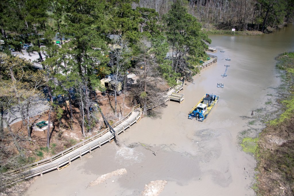
Almost two months after it started, Kayden began demobilizing. Resident Josh Alberson captured the image below with his drone.
Last week, Kayden Industries started demobilizing their equipment. Here we see one of the two dredges getting ready for removal from the water. Kayden brought in a smaller dredge when the City lowered the level of the lake suddenly. The first dredge is up on blocks behind the pile of sand.Photo courtesy of Josh Alberson.This morning, where the shaker once stood, nothing but some sand remains.A giant pile of sand still blocks the boat dock.But dump trucks were lining up to receive the sand and carry it to a placement area in Humble out of the flood plain.The finished job: a beautifully restored lagoon, complete with some marshes to attract birds.
Water along the boardwalk is 3-5 feet deep, so don’t let kids play in it. That could be dangerous.
Some Repaving Left to Do
All the heavy traffic has taken a toll on park roads. “Everyone needs to understand that the paving problems on the road between the gate and the first stop sign were there long before we started trucking dirt,” said Dee Price, KSA President. “We have patched that area numerous times in the past.” Price said KSA needs to mill and re-pave that piece of road as the group did with the soccer road. Price plans to put that project in the next fiscal-year budget. But for now, she says, “We need to patch it again until we can do the major improvement next year.”
Posted by Bob Rehak on April 14, 2020 with thanks to Josh Alberson for the drone imagery
958 Days since Hurricane Harvey
https://i0.wp.com/reduceflooding.com/wp-content/uploads/2020/04/20200413-RJR_0511.jpg?fit=1200%2C800&ssl=18001200adminadmin2020-04-13 13:20:592024-03-12 18:38:56River Grove Dredging Done, Only Cleanup Left