State Representative Charles Cunningham has introduced HB1093. The bill would ensure cleanup of abandoned sand mines in the San Jacinto watershed. It requires miners to post a bond that covers cleanup costs. So, if an irresponsible miner walks away from a mine before reclamation, the public doesn’t have to pay the deadbeat’s costs.
A bond is like an insurance policy that guarantees the performance of obligations.
Without a bond, miners who profited for years from a mine can simply walk away when they are done mining, foisting cleanup costs onto the public or leaving blight behind.
How Bad Is the Problem?
Right now, there are at least six mines on the East and West Forks of the San Jacinto that were left a mess. Such abandoned sand mines are increasingly becoming a blight that imperils water quality in Lake Houston, the source of drinking water for 2 million people.
Rusting equipment leaks poisons and poses safety problems.
Un-stabilized soil increases rates of erosion and contributes to flooding.
Steep banks in pits slump away in slabs threatening neighboring properties and businesses.
Blight reduces surrounding property values and business activity
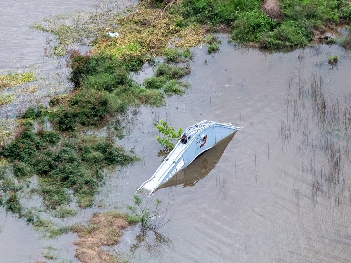
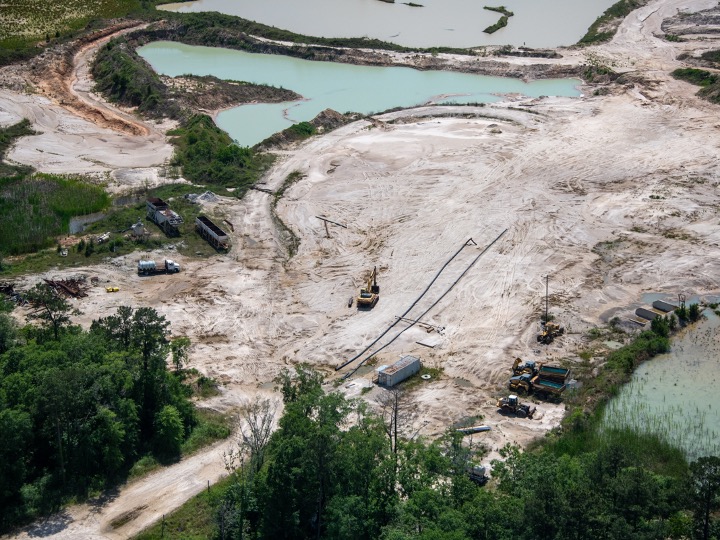
Miners are supposed to remove equipment and structures before they abandon a mine. But not all do. See the pictures below.
Leaking equipment near Riverview Drive in Porter on West Fork. Google Earth images show thisin same location since 2008.Dredge abandoned in Humble mine in 2017.Abandoned excavator in Porter mine on West ForkAbandoned dredge in Plum Grove mine.Abandoned processing equipment in Humble mine.Abandoned processing equipment and vehicle in Humble mine since 2017.
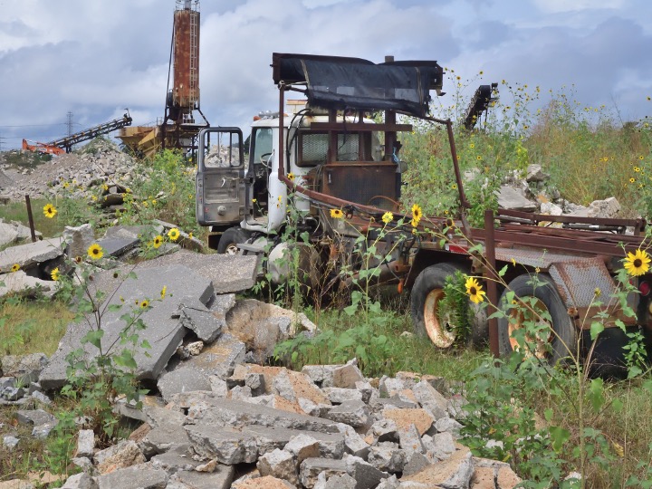
Miners are also obligated to grade and stabilize soil before they leave a mine, then replant vegetation similar to the surrounding area to reduce sediment pollution. But not all do.
Ungraded, un-stabilized soil in East Fork Plum Grove Mine.Ungraded soil and abandoned equipment in East Fork MineA flood later swept through the mine above, sending sediment down the East Fork.Defunct sand pit in Humble. Steep slopes – ungraded and unvegetated – erode and threaten neighboring business.
Community Consequences
Most sand moves during storms. This island appeared after Hurricane Harvey between Humble and Kingwood. It blocked the West Fork by 90%, according to the Army Corps and contributed to the flooding of thousands of homes and businesses.Confluence of the San Jacinto West Fork with Spring Creek. Images taken on different days from different angles, but in each case the dirty water comes from the West Fork, where we have 20 square miles of mines on a 20 mile stretch of the river between I-45 and I-69.
Most responsible miners will clean up on their own. But experience shows, a few bad apples will not. And when they walk away, the cost to the public can be enormous. Dredging costs alone have exceeded $226 million in the Lake Houston area since Harvey.
How You Can Help
Please help reduce this and related cleanup costs in the future. Ensure that sand miners don’t pass their remediation costs on to taxpayers.
Make sure HB1093 at least gets to the House floor for a vote this year.
The committee will likely recommend King’s HB10. It will fund the creation of 7-million acre-feet of new water supplies for rural areas.
Let’s do something that won’t cost taxpayers a penny to protect a water supply we already have. Support HB1093. And please forward this link to all your friends, family and neighbors.
Posted by Bob Rehak on 3/18/23
2027 Days after Hurricane Harvey
The thoughts expressed in this post represent opinions on matters of public concern and safety. They are protected by the First Amendment of the US Constitution and the Anti-SLAPP Statute of the Great State of Texas.
https://i0.wp.com/reduceflooding.com/wp-content/uploads/2023/03/20200306-RJR_9442.jpg?fit=1200%2C800&ssl=18001200adminadmin2023-03-18 09:23:232023-03-18 09:53:52Urgent Request: Support HB1093 to Improve Water Quality, Reduce Flooding, Save Tax Dollars
Tomorrow is the fifth anniversary of Hurricane Harvey. Many in the Lake Houston Area have asked, “Are we safer now?” The answer is yes, but we have a long way to go to achieve all our goals. Here’s a five-year flood-mitigation report card. It describes what we have and haven’t accomplished in 29 areas. So get ready for a roller coaster ride. I’ll leave the letter grades to you.
Lake Houston Area Mitigation
1) Dredging
The most visible accomplishment in the Lake Houston Area since Harvey is dredging. The City and Army Corps removed approximately 4 million cubic yards of sediment blocking the West and East Forks. Before dredging, River Grove Park flooded six times in two months. Since dredging, it hasn’t flooded once to my knowledge.
West Fork mouth bar after Harvey and before dredging. Now gone, but not forgotten.
Potential location for new tainter gates east of the spillway portion of the dam (out of frame to the right.
3) Upstream Detention
To reduce the amount of water coming inbound during storms, the San Jacinto River Basin Master Drainage Study identified 16 potential areas for building large stormwater detention basins. Unfortunately, they had a combined cost of $3.3 billion and would only reduce damages by about a quarter of that.
So, the SJRA recommended additional study on the two with the highest Benefit/Cost Ratio. Their hope: to reduce costs further. The two are on Birch and Walnut Creeks, two tributaries of Spring Creek near Waller County. Expect a draft report in February next year.
Funding these would likely require State assistance. But the Texas Water Development Board’s San Jacinto Regional Flood Planning Group has just recently submitted its first draft report. The draft also recommended looking at detention basin projects on West Fork/Lake Creek, East Fork/Winters Bayou, and East Fork/Peach Creek.
Building them all could hold back a foot of stormwater falling across 337 square miles. But funds would still need to be approved over several years. We’re still a long way off. Results – on the ground – could take years if not decades.
4) “Benching”
The Regional Flood Planning Group also recommended something called “benching” in two places along 5 miles of the West Fork. In flood mitigation, benching entails shaving down a floodplain to create extra floodwater storage capacity. Like the detention basins, benching is still a long way off…if it happens at all.
5) West Fork Channel Widening
Finally, the Regional Flood Planning Group recommended widening 5.7 miles of the West Fork to create more conveyance. But again, at this point it’s just a recommendation in a draft plan.
San Jacinto River Authority
6) SJRA Board Composition
After Harvey, many downstream residents accused SJRA of flooding downstream areas to save homes around Lake Conroe. At the time, SJRA’s board had no residents from the Humble/Kingwood Area. So Governor Abbott appointed two: Kaaren Cambio and Mark Micheletti. Cambio later resigned due to a potential conflict of interest when she took a job with Congressman Dan Crenshaw. That leaves Micheletti as the lone Humble/Kingwood Area resident on a seven-person board. However, the SJRA points out that the Board’s current president, Ronnie Anderson, represents Chambers County, which is also downstream.
State Representative Will Metcalf, who represents the Lake Conroe area, introduced a bill to limit SJRA board membership to upstream residents. Luckily for downstream residents, it failed.
7) Lake Conroe Lowering
SJRA identified temporary, seasonal lowering of Lake Conroe as a strategy to reduce downstream flood risk until completion of dredging and gates projects in the Lake Houston Area. The lowering creates extra storage in the lake during peak rainy seasons. After SJRA implemented the plan, Lake Conroe residents objected to the inconvenience. They sued SJRA and the City, but lost. After discussion with all stakeholders, the SJRA quietly modified its plan. It still lowers the lake, but not as much.
8) Lowering Lake Houston
Houston also started lowering Lake Houston, not seasonally, but in advance of major storms. The City has lowered the lake more than 20 times since beginning the program. That has helped to avoid much potential flooding to date.
9) Lake Conroe Dam Management
SJRA applied for and received several TWDB grants to enhance flood mitigation and communications in the San Jacinto River Basin. One involves developing a Lake Conroe Reservoir Forecasting Tool. SJRA has also worked with San Jacinto County to develop a Flood Early Warning System.
Finally, SJRA’s Lake Conroe/Lake Houston Joint Reservoir Operations Plan is on hold pending completion of the City’s plan to add more gates to the Lake Houston dam. Such projects may help reduce the risk of releasing unnecessarily large volumes of water in the future.
However, the location is controversial. Geologists say it wouldn’t reduce sediment in the area of greatest damage. Environmentalists worry that it could increase sedimentation through a “hungry-water” effect and open the door to river mining. And I worry that, even if successful, the pilot study would not be extendable. That’s because it relies on partnerships with sand miners. And other tributaries to Lake Houston do not have sand mines or as many sand mines.
Sand bar blocking West Fork after Harvey. The Corps has since removed it.
Federal Funding
It’s hard to get good grades on your flood mitigation report card without funding.
$1.6 million for HCFCD for Taylor Gully stormwater channel improvement.
$1.6 million for HCFCD for Kingwood Diversion Channel improvement.
$1.67 million for Harris County for the Forest Manor drainage improvement project in Huffman.
$8.2 million from FEMA the Westador Basin stormwater detention project on Cypress Creek.
$9.9 million from FEMA for the TC Jester storm water detention basin on Cypress Creek.
Crenshaw also has backed community requests for more funding in Fiscal 23. They include:
$8 million for the Lake Houston Dam Spillway (Gates).
$10 million for the Woodridge Stormwater Detention Basin (see below).
$10 million for a Cedar Bayou Stormwater Detention Basin.
Harris County Flood Control
19) Channel Maintenance and Repair
Harris County Flood Control has already completed several maintenance projects in the Lake Houston Area. In Kingwood, those projects include Taylor Gully, Ben’s Branch, parts of the Diversion Ditch and other unnamed ditches. In Atascocita, HCFCD also completed a project on Rogers Gully. Upstream, HCFCD is working on the third round of repairs to Cypress Creek. Batch 3 includes work at 12 sites on 11 channel sections. I’m sure the District has maintenance projects in other areas, too. I just can’t name them all.
Bens Branch near Kingwood High School after sediment removal.
In 2019, uncontrolled stormwater from the Woodridge Village development twice flooded approximately 600 homes in Elm Grove Village and North Kingwood Forest. HCFCD and the City purchased Woodridge from Perry Homes last year. HCFCD soon thereafter started removing sediment from the site to create a sixth stormwater detention basin that would more than double capacity on the site. At the end of last month, contractors had removed approximately 50,000 cubic yards out of 500,000 in the contract. This gives HCFCD a head start on excavation while engineers complete the basin’s final design.
21) Local Drainage Study Implementation
HCFCD authorized four studies of the drainage needs in the Lake Houston Area. They completed the Huffman and Kingwood studies. Atascocita and East Lake Houston/Crosby started earlier this year and are still underway.
The Kingwood study measured levels of service in all channels and outlined strategies to improve them to the 100-year level. The first two projects recommended: Taylor Gully and the Kingwood Diversion Ditch. Neither has started construction yet. But see the notes under funding above.
The Huffman Study recommended improvements to FM2100, which TxDOT will handle. It also recommended dredging in the East Fork near Luce Bayou which the City has completed. Finally, it recommended a bypass channel for Luce. However, pushback from residents forced cancellation of that project.
22) Buyouts
HCFCD completed buyouts of 80+ townhomes on Timberline and Marina Drives in Forest Cove last month. Contractors demolished the final run-down complex in August. That should improve property values in Forest Cove.
Completion of demolition of one of the last Forest Cove Townhome Complexes in July 2022.
23) Regulation Harmonization
Harris County Flood Control and Engineering have been working to get municipalities and other counties throughout the region to adopt certain minimum drainage regulations. I discussed the importance of uniformly high standards in last night’s post. So far, about a third of the governments have upgraded their regs. A third are still deciding whether to act. And the remainder have taken no action. There has been little movement in the last six months.
City of Houston
As mentioned above, the City has taken a lead role in dredging, adding gates to Lake Houston, and proactive lake lowering. In addition, the City has helped with:
24) Bridge Underpass Clean-Out
The City of Houston successfully cleaned out ditches under Kingwood Drive and North Park Drive in at least six places. Bridges represent a major choke point during floods. So eliminating sediment buildups helps reduce flood risk in areas that previously flooded.
Excavation of Bens Branch under Kingwood Drive by City crews.
The lowest score on the flood-mitigation report card probably goes to LSGCD.
26) Subsidence
The Lone Star Groundwater Conservation District has started pumping groundwater again at an alarming rate. Projected subsidence near the Montgomery County Border equals 3.25 feet, but only 1 foot at the Lake Houston dam. That could eventually tilt the lake back toward the Humble/Kingwood/Huffman area and reduce the margin of safety in flooding. That’s bad news.
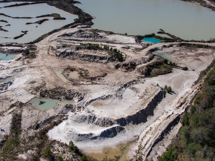
Sand Mining Regulations
Twenty square miles of West Fork sand mines immediately upstream from I-69 have exposed a swath of floodplain once covered by trees to heavy erosion during floods. Mathematically, the potential for erosion increased 33X compared to the normal width of the river. Sand mines were also frequently observed releasing sediment into the river. And the dikes around the mines often wash out.
So in 2019, the Lake Houston Area Grassroots Flood Prevention Initiative (LHAGFPI) began meeting with legislators, regulators and the Texas Aggregate and Concrete Association (TACA). The goal: to establish comprehensive Best Management Practices (BMPs) for the sand mining industry in the San Jacinto River Basin.
27) Mine Plan/Stabilization Reports Now Required
TCEQ adopted new regulations, effective January 6, 2022. They required miners to file a ‘Mine Plan’ by July 6, 2022 and also a ‘Final Stabilization Report’ when a mine is played out.
28) Vegetated Buffer Zones (Setbacks)
The new regs also stipulate undisturbed vegetative buffer zones around new mines. Buffer zones aid in sediment filtration and removal by slowing surface water. They also strengthen dikes.
The new regs require a minimum 100-foot vegetated buffer zone adjacent to perennial streams greater than 20 feet in width. However, for streams less than 20 feet wide, the buffer zone is only 50 feet for perennial streams, and 35 feet for intermittent streams.
29) Reclamation Bonds
Unfortunately, the Flood Prevention Initiative could not convince TCEQ to require ‘reclamation bonds.’ Other states use such bonds to prevent miners from abandoning mines without taking steps to reduce future erosion, such as planting vegetation.
My apologies to any projects or parties I omitted. Now it’s your turn. Give grades to those you think have done the best job on YOUR Harvey flood-mitigation report card.
Posted by Bob Rehak on 8/26/22
1823 Days since Hurricane Harvey and one day from Harvey’s Fifth Anniversary
https://i0.wp.com/reduceflooding.com/wp-content/uploads/2021/04/20210416-DJI_0406.jpg?fit=1200%2C900&ssl=19001200adminadmin2022-08-26 22:09:382022-08-27 12:10:28Harvey: A 5-Year Flood-Mitigation Report Card
The Colony Ridge development in Liberty County, aka the world’s largest trailer park, has more than doubled in size in the last 3 years. Measurements in Google Earth show that Colony Ridge, which started clearing land in 2012, has expanded from approximately 8,000 acres in 2019 to almost 20,000 acres today. To put that in perspective, Kingwood comprises approximately 14,000 acres and took more than 40 years to build out.
Colony Ridge started developing on the left (west). It is expanding eastand north.
Growing Pains
But the rapid growth of Colony Ridge has not come without pain:
Rivers of mud continue to flow out of drainage ditches with big rains because the developer flaunted construction regulations for them.
Consequences of Poor Construction Practices
As a result of such drainage issues and exposed soils, more sediment flows downstream than otherwise would. This contributed to sediment buildups on the San Jacinto East Fork (see below). Those, in turn, reduce conveyance and contribute to downstream flooding – unless the public continues to spend millions on dredging.
East Fork Mouth Bar after Imelda but before recent dredging. Average river depth had been reduced to three feet.
Still Not Following Best Practices
Aerial photos taken on 7/22/2022 with Ken Williams and Bill Callegari, two fellow members of the Harris County Community Flood Resilience Task Force, show the current state of the development and construction practices in Colony Ridge. Sadly, not much has improved. For instance, the developer still piles dirt on the edge of ditches without protecting them with silt fences.
Note long drainage ditch cutting diagonally through middle of frame. Developer has piled dirt next to it (middle left of frame) without protecting ditch with silt fencing.Major ditch cutting through older section is sill not protected with back-slope interceptor swales or vegetation.Erosion is rampant.
Water shooting down the ditch above created a major headache during Harvey. See below.
FM 1010 Still Washed Out
Floodwater from the ditch washed out FM 1010. This major N/S thoroughfare still needs repair…five years later!
Break in FM 1010, aka Plum Grove Roadforces residents to detour for miles.
Photos Showing New Development
Area developed last year is starting to fill in with new trailer homes already.Note absence of fire hydrants…still.Looking east at area still under construction.Looking E from NE corner of development.Another area semi-cleared but still unpaved.
If there’s good news in these photos, it is that the developer appears to be leaving more natural ground cover in the newest areas. Still, without vegetation on the sides of ditches, without better construction practices, excess sediment could continue washing into the Lake Houston Area for years to come.
Downstream residents will continue to pay the price for egregious development practices upstream.
Someday, the people who buy these lots will also become flood victims of similar new developments even farther upstream.
Will we continue to repeat mistakes of the past in ever widening circles? Will we continue to sow the seeds of future flooding? Or will we wake up to the fact that we are all part of one giant community?
Posted by Bob Rehak on 7/23/2022
1792 Days since Hurricane Harvey
The thoughts expressed in this post represent opinions on matters of public concern and safety. They are protected by the First Amendment of the US Constitution and the Anti-SLAPP Statute of the Great State of Texas.
https://i0.wp.com/reduceflooding.com/wp-content/uploads/2022/07/20220726-Screen-Shot-2022-07-26-at-10.27.55-AM-2.jpg?fit=1200%2C854&ssl=18541200adminadmin2022-07-26 15:04:302022-08-29 15:09:39Controversial Colony Ridge Development Doubles in Size
When last I reported on Lake Houston dredging, the focus of operations had shifted from the East Fork to Rogers Gully. However, the dredgers were still stationed hundreds of feet offshore. According to State Representative Dan Huberty, shallow water forced them to dredge their way into the Gully. (See below.)
Location of dredge on March 1, 2022.Mouth bars, like the one in the foreground are deposited where water slows down as it reaches the lake.
Compare Photos Taken Today
Now, 2.5 months later, the dredgers have reached the Rogers Gully mouth bar and have completed dredging most of it.
Looking east toward Lake Houston. Compare photo above.Looking west toward the Walden Country Club, upper right.
Aerial photos taken this afternoon show that all but a small portion has already been removed. The operation could be completed in the next week or two, weather permitting.
Pontoons ferry the spoils to a converted marina across the lake now used as a temporary placement area. From there, trucks take the spoils to a fill-dirt company on FM1960 near SH99 east.
Before Dredging Began
To appreciate the progress, compare the photo below taken two years ago.
Rogers Gully Mouth Bar on June 16, 2020 before dredging started.
It’s not clear yet where the dredges will go next. They’re on a mission, with money that Huberty helped obtain from the legislature, to open up more ditches and streams that empty into Lake Houston. Blockages like the one at Rogers Gully can reduce the conveyance of streams. They create sediment dams that back water up. And that contributes to flooding homes and businesses behind them.
Within the last week, the focus of dredging moved from the East Fork San Jacinto to the mouth of Rogers Gully on the west side of Lake Houston near the Walden Country Club. HCFCD conducted a dredging operation upstream from the Rogers Gully mouth bar in 2020. But the mouth bar itself is in Lake Houston, which is owned by the City of Houston. So this portion is the City’s responsibility.
Where dredging stopped in East Fork in late February. Looking South. Luce Bayou on upper left. FM1960 Bridge in upper right.Picture taken 2/27/22.Rogers Gully mouth bar has already been partially removed by the dredgers anchored in the distance for the evening.Looking east toward Huffman on far side of lake from over the Walden Country Club.Photo taken 3/1/22.
New Base of Operations Will Shorten Supply Lines
At the same time, the base of operations for dredging appears to be moving from the West Fork to a marina across the lake from Rogers Gully. The new drop off point for spoils is about 2.2 miles from Rogers Gully. Compare that to almost 7 miles to get from the East Fork to Berry Madden’s property south of River Grove Park on the West Fork.
New deposit site for dredging spoils on Fairlake Lane in Huffman.Photo taken 2/27/22.
Over the weekend, I photographed dredgers preparing the site and carting the first loads of sediment to a dirt/mulch company about six miles east on 1960.
Where spoils from Lake Houston are going on FM1960 toward 99.
The dirt company is about 2 miles inside the new Grand Parkway extension.
Looking south. New Grand Parkway extension crossing FM1960. Photo taken 2/27/22.
The new highway will open vast new areas for development and create ready markets for dredging spoils to elevate homes and build roads.
Focus Shifting to Inlets Around Lake
According to State Representative Dan Huberty, about $40 million remains in the dredging fund appropriated by the state legislature last year. He hopes that after inlets around the lake are cleaned out, that dredgers will return to the East Fork in the future to continue the effort there.
Pictures taken this afternoon show that in the last two days, the dredgers have taken a significant bite out of the Rogers Gully mouth bar, which in my opinion, was the worst of many smaller inlets around the lake.
Rogers Gully mouth bar in August of 2020. Compare to photos below to see progress already made.
The photos below tell the story.
Looking west from beyond one of the anchored dredges toward the mouth bar and the Walden Country Club in the top center.Still looking west at the partially removed mouth bar.Looking NNW.From here, tugs will ferry the pontoons toward the general vicinity of that white spot on the lake front in the upper right.Note the FM1960 bridge in the background.
Soon, the dredgers will finish with Rogers Gully and move on to the next inlet.
Posted by Bob Rehak on 3/1/22 with input from Dan Huberty
1645 Days since Hurricane Harvey
https://i0.wp.com/reduceflooding.com/wp-content/uploads/2022/03/20220301-DJI_0429.jpg?fit=1200%2C799&ssl=17991200adminadmin2022-03-01 19:01:142022-03-01 19:09:52Dredgers Move to Rogers Gully from East Fork
Mechanical dredging is sloooooooooow. Two months after my last dredging update, contractors are still working on the same portion of the East Fork Mouth Bar complex just north of the entrance to Luce Bayou. The sand bar is question is one of many in the area that popped up after Harvey and Imelda.
Pictures Taken on 1/28/22
I took the first three images below this morning.
Looking East across the San Jacinto East Fork from Kingwood toward Luce Bayou in upper right. North is to the left.Photo taken on 1/28/22.Dredgers are now working on a small island just upstream from Luce. But there’s a lot of work yet to do.Photo taken on 1/28/22.
The San Jacinto East Fork Mouth Bar grew more than 4,000 feet in length during Harvey and Imelda. River depth was reduced to 3 feet, according to boaters. That reduced conveyance of the river and contributed to flooding of homes on both sides.
It took three months just for contractors to dredge their way through the Royal Shores channel to get to East Fork (July, August, September 2021). East Fork dredging started in October last year. Removing sediment from the area in red above has taken four months. But it’s only a small portion of the work that needs to be done as you can see in the second image above that looks upstream.
Naturally, residents are asking, “How much more does the City intend to do?” The answer to that question is still unsettled.
Vendor for Long-Range Dredging Plan Still Not Decided
The project attracted a lot of attention. Thirteen companies expressed interest. And eleven signed up for a pre-bid conference. However, the purchasing agent for the City, Bridget Cormier, stated that “The City has not yet made a decision, nor a recommendation for award yet.” She explained, “We are still in the evaluation phase and have requested additional information from suppliers that moved forward in the process.”
Posted by Bob Rehak on 1/28/2022
1613 Days since Hurricane Harvey
https://i0.wp.com/reduceflooding.com/wp-content/uploads/2022/01/20220128-DJI_0561.jpg?fit=1200%2C799&ssl=17991200adminadmin2022-01-28 13:34:082022-01-28 14:28:52Dredgers Still Nibbling Away at East Fork Mouth Bar
To compensate for the potential shortfall, Commissioners established a flood-resilience trust with money from other Harris County departments and changed equity guidelines in June.
To help you follow this story, I make quarterly FOIA requests for Harris County Flood Control District spending and post the analyses on a dedicated funding page.
Sand-Mining Best Management Practices
Activists led by the Lake Houston Area Flood Prevention Initiative and the Bayou Land Conservancy petitioned the Texas Commission on Environmental Quality (TCEQ) to establish best management practices for sand mines in the San Jacinto watershed. We didn’t get everything we wanted, but we got a vast improvement over what we had. And the new BMPs may help reduce erosion that contributes to future floods in this area.
West Fork Sand Mine illustrates need for vegetative controls to reduce erosion.
May 9, 2021, was 1349 days after Hurricane Harvey ravaged Texas and the Gulf Coast. That’s the number of days it took the US and its allies to win World War II. But during that time we’ve had few victories in the fight against future flooding in the Lake Houston Area with the exception of dredging, So far, we’ve mainly completed studies. And many of those are still in the works.
For instance, the City of Houston has been studying ways to increase the release capacity of the Lake Houston Dam. Right now, the release capacity is one-fifteenth that of the gates on Lake Conroe. That makes it difficult to shed water quickly before and during floods. FEMA gave the City money to study the problem, but is still finalizing recommendations. The City hopes to make an announcement in January.
The Texas Attorney General is still suing the Triple PG Sand Mine in Porter on behalf of the TCEQ. There has been little movement on the case in the last 18 months. The mine’s owner changed legal counsel in July 2020. A TCEQ representative says the AG has not given up. The two sides are still in discovery.
Approximately 1700 homeowners in the Lake Houston Area sued sand mines for contributing to flooding during Harvey. The cases were consolidated in the 281st Harris County District Court under Judge Sylvia Matthews. She recently set deadlines in the first half of next year for motions, depositions, joinder, expert witness testimony and more. The case is known as “Harvey Sand Litigation.”
Various lawsuits against the SJRA for flooding during Harvey are still working their way through the legal system.
Kingwood residents reached a settlement with Perry Homes, its subsidiaries and contractors this year over two floods that damaged hundreds of homes in Elm Grove and North Kingwood Forest during 2019. The incidents had to do with development of Woodridge Village, just across the Harris/Montgomery County line.
East Fork Dredging. Photographed in early December between Huffman and Royal Shores in Kingwood.Looking south toward Lake Houston.
Bens Branch and Taylor Gully Cleanouts
In Kingwood, HCFCD finished excavating both Bens Branch and Taylor Gully to help restore their conveyance. Through gradual sediment built up, both had been gradually reduced to a 2-year level of service in places. That means they would come out of their banks after a 2-year rain.
Final phase of Bens Branch maintenance between Kingwood Drive and Rocky Woods. Note Kingwood High School in upper right.
GMA-14 will take a final vote on January 5 on the final DFCs. You still have time to protest.
Posted by Bob Rehak on 12/31/2021
1585 Days since Hurricane Harvey
https://i0.wp.com/reduceflooding.com/wp-content/uploads/2021/06/20210303-RJR_5778.jpg?fit=1200%2C800&ssl=18001200adminadmin2021-12-31 10:48:382021-12-31 11:09:51Top Stories of 2021 in Review
Rider to SB 1 Added During Last Conference Committee
The rider actually stipulates the money will go to the Texas Water Development Board but earmarks it. The text says in part, “Water Development Board shall allocate $50,000,000 for the state fiscal biennium beginning September 1, 2021, for the purpose of providing financial assistance for removing accumulated siltation and sediment deposits throughout the San Jacinto River and Lake Houston.”
The bill became effective on 9/1 after a final conference committee, vote and the Governor’s signature. Huberty credits Chairman of the House Appropriations Committee, Greg Bonnen, Representative Armando Walle, also on the House Appropriations Committee. Huberty said, Bonnen helped it go in and Walle made sure it stayed in.
Huberty said the money will be used to keep dredging continuously as long as it lasts. The City will actually be doing the dredging (see photos below). Huberty also credits Mayor Sylvester Turner and Mayor Pro Tem Dave Martin for working to make the appropriation happen.
Where Money Will Be Used
In addition to East Fork dredging, Huberty sees the money being used to clear accumulated siltation from the mouths of inlets around the lake, such as those in Huffman, Atascocita and Walden.
Update on Status of East Fork Dredging
Shortly before sundown today, I put a drone up from Kingwood over the East Fork and captured the images below.
Looking SE toward Luce Bayou entrance to East Fork and one of two mechanical dredges currently on station.Closer shot of same dredge. Note: all photos were taken just before sunset on Saturday night, 11/20/21.Looking south toward Lake Houston, West Fork confluence (upper right) and FM1960 bridge in distance.Looking North. Kingwood on left; Huffman on right.
The shot above shows you just how big this task will be. I first photographed these dredges in the East Fork on October 12. So it’s taken them roughly five weeks to excavate the sandbar between the two pontoons.
Below, you can see what the same area looked like almost a year before dredging started. The photo gives you some idea of the immensity of the task. The sand bars you see grew 4000 feet in length during Harvey and Imelda.
East Fork Mouth Bar after Imelda. Taken in December 2020, ten months before start of East Fork dredgingabout five weeks ago.
Josh Alberson who boats this area regularly with a shallow draft jet boat found that the depth of the river through his reach had been reduced from 17 feet before Harvey to about 3 feet after Imelda. That’s a major loss of conveyance that backed water up and contributed to flooding on both sides of the river.
Smaller tributaries exhibit similar problems, for instance Rogers Gully.
Rogers Gully mouth bar in Atascocita
Thank You Dan and God Speed
Everyone in the Lake Houston Area owes Dan Huberty a huge “thank you” for this one. Huberty, who has served in the House for 10 years, has announced his intention not to run again. Throughout his tenure, Huberty helped reform state education funding. He also passed regulation that forced sand mines to register with the TCEQ during his freshman year in 2011. God speed on the next leg of your journey, Dan.
Posted by Bob Rehak on 11/20/21
1544 days after Hurricane Harvey
https://i0.wp.com/reduceflooding.com/wp-content/uploads/2021/11/20211120-DJI_0872.jpg?fit=1200%2C799&ssl=17991200adminadmin2021-11-20 19:26:272021-11-20 21:11:14Huberty Secures Another $50 Million for Lake Houston Dredging
This morning, for the first time, I photographed dredging on the San Jacinto East Fork. It was a welcome site and one that hundreds of East Fork residents who flooded will appreciate.
Three Months After Plans Unveiled
It was back on July 9, 2021, that Stephen Costello, the City’s Chief Recovery Officer, unveiled the City’s plans to begin East Fork dredging. At the time, Costello said crews would have to dredge their way there through a shallow channel south of Royal Shores in Kingwood.
Finally, today, October 12, three months later, I photographed a barge moving straight through the channel and into the East Fork. I even had to move locations a couple time to keep the drone within range.
Drone Photos of East Fork Dredging from 10/12/2021
Two mechanical dredges on East Fork, just upstream from the entrance to Luce Bayou.
Today’s dredging location circled in red. Arrow points way back to where crews are depositing the spoils on the West Fork just south of River Grove Park.
Tug pushing empty pontoon through Royal Shores Channel toward East Fork (top). Looking SE. Note FM1960 Causeway in upper right.
Looking NE toward Luce Bayou on opposite shore to begin Dredging
Empty barge turns NNE. East Fork dredging location is around the finger that sticks out into the river from the upper left. After loading up with silt and sediment, the barge will return to the West Fork to deposit the spoils.
More Dredging $$$ Voted by Commissioners Today
This morning, in Harris County Commissioners Court, Agenda Item 102 passed unanimously without discussion. The motion will contribute $10 million from the Harris County 2018 flood bond funds to extend the dredging on the East Fork, West Fork, and Lake Houston, including the entrance to Rogers Gully.
Posted by Bob Rehak on 10/12/2021
1505 Days since Hurricane Harvey and 756 since Imelda
https://i0.wp.com/reduceflooding.com/wp-content/uploads/2021/10/20211012-DJI_0526.jpg?fit=1200%2C799&ssl=17991200adminadmin2021-10-12 14:56:532021-10-12 15:16:52San Jacinto East Fork Dredging Begins
Hurricane Nicholas likely affected the schedule with the twin needs to secure equipment and lower the lake.
Regardless, when I put up a drone today, I found good news. The dredging is now much closer to the east fork than the west.
Dredging has now reached homes in Royal Shores. Looking south toward FM1960and Lake Houston.
Looking east toward the East Fork. Dredging should break through in about another 1000 feet, the width of another six or seven homes.
Assuming the City can maintain a pace of 200 feet per week, that would put crews in the East Fork by the end of October.
Distance dredged in three weeks since last update on August 28th.
Looking west. At present, there appear to be two crews working. Note one still way out near the west fork, widening or deepening the channelnear where they started in mid-July.
This certainly is one of the most beautiful parts of Houston for those who can afford to live with the flood risk.
Proposals for Long-Range Dredging Plan Due Today
A damage map compiled shortly after Harvey showed that 1290 Harris County homes flooded in the East Fork watershed.
https://i0.wp.com/reduceflooding.com/wp-content/uploads/2021/09/20210923-DJI_0475-2.jpg?fit=1200%2C800&ssl=18001200adminadmin2021-09-23 16:39:092021-09-23 19:08:06Dredging Now Closer to East Fork Than West