Hallett Mine Leaking into West Fork for Full Year
2/23/2025 – The mammoth Hallett Sand Mine has been leaking continuously into the San Jacinto West Fork for a year, according to neighbors. I first reported this particular leak on February 9, 2024.
But it’s only one of several problems at the same mine. And the cost of dredging downstream from it is now approaching the annual budget of the TCEQ statewide.
Photos, Video Show Route and Volume of Leak
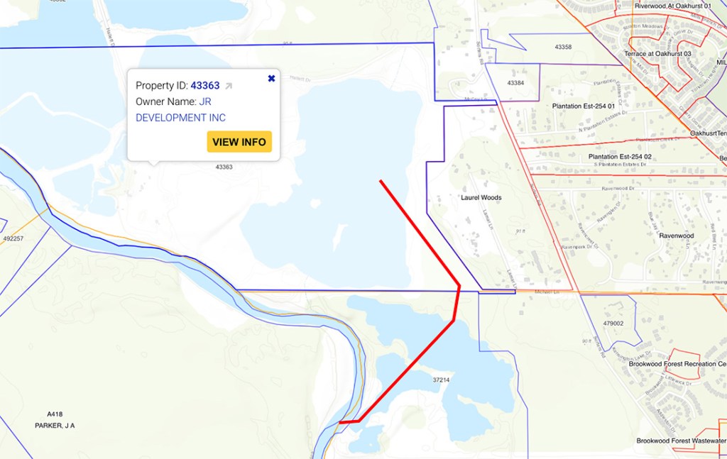
The leak comes straight out of Hallett’s settling pond and cuts across a service road. The sediment-laden water then flows through wooded property bordering neighbors’ back yards, which it has reportedly invaded from time to time.
From there, the milk-white muck travels to an abandoned sand mine now owned by a real estate developer. That mine’s dike was breached in 2020 after Harvey’s floodwaters severely weakened it in 2017.
As a result of the breach in the neighboring mine, Hallett’s sediment-laden water enters the West Fork without interference, and then travels downstream to Lake Houston, the source of drinking water for more than two million people.
In addition to raising water treatment costs for the City of Houston, such leaks have also been linked to sediment buildups that have reduced the conveyance of the West Fork and contributed to flooding in the Lake Houston Area.
See the pictures below taken today, 2/23/25.

Settling pond on left. Red line indicates path of wastewater through woods, an abandoned mine, and then into the West Fork.
To fully appreciate the volume of the wastewater leaking out of the mine, see the video below. It runs a little longer than one minute.

I have also reported on separate leaks from this same pond into the same abandoned mine via additional routes in January 2021 and May 2024.
River Flowing Through Former Hallett Pit Now Owned By Riverwalk Porter LLC
In the same area, sand mining has created more problems. Across the river, a large mile-long sand pit formerly owned by Hallett ruptured shortly after they sold it to a residential developer named Riverwalk Porter LLC last year.

It still hasn’t been fixed and the river is no longer navigable without cutting through their private property. That pile of sand in the middle of the photo above is an estimated 8 to 10 feet above the river’s normal water line.
When the TCEQ investigated this pit capture last year, the Commission’s report did not even mention the term “pit capture.”
Neither does the report mention numerous other pit captures elsewhere in the river basin, including another at the Hallett Mine just upstream from this one. The four month investigation did not:
- Result in any reprimands, letters of enforcement, or violations.
- Refer to any water-quality measurements, even though the complaints concerned water quality.
- Address other sand-mine dike beaches and emissions in the same area
- Explore downstream impacts.
The TCEQ also failed to address pit captures in its latest Best Management Practices proposed for sand mines in the San Jacinto River Basin.
No wonder the TCEQ is called a “reluctant regulator.” In my opinion, this goes beyond willful blindness to intentional stupidity. The TCEQ’s annual budget is around $300 million. But the cost of dredging downstream from the Hallett mine is pushing $200 million and climbing.
Editorial comment to Governor Abbott: Wouldn’t it be more cost effective just to put TCEQ salaries straight into a perpetual dredging program?
River Still Flowing Through Another Hallett Pit Upstream
Another photo taken today shows that another Hallett sand pit farther north also remains captured by the San Jacinto River. The river has been flowing through the pit rather than around it since at least June of last year.

TCEQ failed to investigate this pit when it investigated the other pit just a mile downstream.
Posted by Bob Rehak on February 23, 2025
2735 Days since Hurricane Harvey
The thoughts expressed in this post represent opinions on matters of public concern and safety. They are protected by the First Amendment of the US Constitution and the Anti-SLAPP Statute of the Great State of Texas.


