A scientific study published in the journal Nature Sustainability on December 9th claims flooding is the costliest form of natural disaster. It also claims that those costs should increase due to new developments built in floodplains. Overall, the study found that for large areas, avoided damages exceed land acquisition costs by a factor of at least five to one. “Strategic conservation of floodplains would avoid unnecessarily increasing the economic and human costs of flooding while simultaneously providing multiple ecosystem services,” says the study.
Avoided Damages Can Exceed Land Acquisition Costs Up to 5:1
The new study by The Nature Conservancy (TNC), the University of Bristol (United Kingdom) and flood analytics company Fathom seeks to answer an important question related to flooding in the United States: What would save American taxpayers more? Protecting undeveloped flood-prone areas now or allowing development and paying for flood damages when they inevitably occur?
“A dollar invested in floodplain protection today returns at least $5 in savings from avoided flood damages in the future,” says Kris Johnson, PhD, The Nature Conservancy’s North America Deputy Director of Agriculture and one of the study’s authors.
High-density starter homes in Northpark Woods near West Fork San Jacinto flood plain. Photo taken 10/4/2019.
Flooding Costliest Form of Natural Disaster
TNC points out that “Flooding is among the most common of natural disasters. And it is the costliest. Average flood losses in the U.S. have increased steadily to nearly $10 billion annually. Meanwhile, the American taxpayer-backed National Flood Insurance Program is in record debt at nearly $25 billion.”
Would It Work in Houston?
Houston Chronicle reporter R.A. Schuetz interviewed several people at Harris County Flood Control about whether the national benefits found in the study translated to Harris County.
The Chronicle quoted Robert Lazaro, a communication officer with Flood Control. Lazoro agreed that buying land likely to flood plays an important role in minimizing future damages. “We’ve found that an ounce of prevention is definitely worth a pound of cure down the road,” Lazaro said.
However, Lazaro also felt the national analysis may not take into account regional regulations and other considerations, such as elevation requirements. Regardless, he hoped that it would inspire local policymakers to consider measures to reduce future flood damages.
Buy Low Before Population Arrives
The trick, it seems is getting to areas before they become highly populated and the price of housing is pushed up by the limited availability of land.
Net: the findings of this article may make more sense in rural counties surrounding major metropolitan areas, such as Chambers, Walker, Grimes, Liberty, Waller and Chambers.
Applying the Principle to the Elm Grove Disaster
The people in Elm Grove and North Kingwood Forest sure wish the community had gotten together and purchased the Woodridge Village land for preservation. It sold to Perry Homes’ for about a million dollars, and had it been left in its natural state might have prevented an estimated $100 million in property damage.
Good market research has a knack of clarifying the obvious. This study did that. It quantified once again that an ounce of prevention is worth a pound of cure.
Posted by Bob Rehak on 12/26/2019
849 Days after Hurricane Harvey and 98 after Imelda
https://i0.wp.com/reduceflooding.com/wp-content/uploads/2019/10/EF-WF-Aerial_585.jpg?fit=1500%2C1000&ssl=110001500adminadmin2019-12-26 17:47:332019-12-26 17:48:49Study Shows It’s Cheaper to Preserve Floodplains Than Buy Out Properties After They Flood
Numerous people have sent ReduceFlooding.com stories about how Perry Homes and Kathy Perry Britton changed their Christmas. Some are real and some are just expressions of anger.
Adaptations Reported by Residents This Christmas
Stringing Christmas tree lights three feet up from the floor for safety.
Converting Christmas yard decorations to blow up plastic types that float.
Monitoring radar screens for storms instead of Santa.
Instead of toys, kids get interior doors, Home Depot gift cards, wallboard and wet vacs.
Ornamental reindeer on the roof equipped with scuba gear.
Several folks have also shared their letters to Santa:
Dear Santa, All I want for Christmas is for you to get Perry Homes to finish the job they started so we can be safe.
Dear Santa,
Our elderly neighbors and the children are suffering. So please make Kathy Perry Britton admit her mistakes, apologize and go away.
Dear Santa,
Perry Homes has done nothing to stop flooding since May. Imelda proved that. We need someone who knows what they’re doing to step in and fix things.
CEO Deprived Thousands of Christmas
Yep. You get the idea. The Grinch has nothing on Kathy Perry Britton. The new “Queen of Mean” has already taken homes, Thanksgiving and Christmas from thousands of kids. Ms. Britton could soon take Easter, too. She:
This is the stuff of legend. Or delusion. Perhaps we buy her a one-way Greyhound ticket to Guatemala.
No. On second thought, Guatemala is too nice. Other ideas gratefully accepted.
Posted by Bob Rehak on 12/25/2019 with input from Jeff Miller, Isabelle Fleenor and the community
848 Days after Hurricane Harvey and 95 since Imelda
https://i0.wp.com/reduceflooding.com/wp-content/uploads/2019/12/Merry-Perry.jpg?fit=1200%2C672&ssl=16721200adminadmin2019-12-25 13:49:532019-12-25 14:09:56Elm Grove Says Merry Christmas to Perry Homes and Kathy Perry Britton in Strange and Wonderful Ways
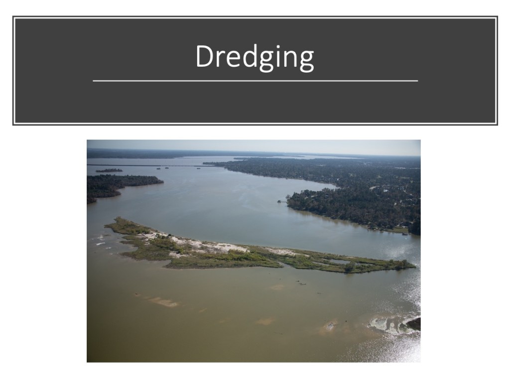
After a year of dredging, the Army Corps and its contractors are gone. Even though they didn’t get all of the West Fork Mouth Bar, they made dramatic conveyance improvements on the West Fork as these before/after photos show.
Sand Island Before Dredging
The first was a blockage that dredging contractors nicknamed “Sand Island.” It sat in the middle of the river just downstream from River Grove Park in Kingwood. According to the Corps, it blocked 90% of the river.
Sand Island formed during Hurricane Harvey. Boats that drew 18 inches of water could not navigate upstream past this giant sandbar.Photo taken 9/14/2019.
Sand Island After Dredging
Sand Island is now Gone Island.Photo taken 12/3/2019.
The Corps removed approximately 15 feet of sand over a 15 acre area that was 566.7 feet wide at its widest point. An acre is about the size of a football field. So this would be like stacking sand on a football field 225 feet high (15×15)! And that doesn’t even include the sand they removed from the channels on either side of the island in the background.
Sand Island Dredging Profile.
Diversion Ditch Bar Before Dredging
A second huge sand bar deposited by Harvey blocked the Kingwood Diversion Ditch, also at River Grove Park. The Diversion Ditch empties the western third of Kingwood. Approximately 600 homes flooded above this one blockage. They were in Barrington, Kingwood Cove, Trailwood, Kingwood Lakes and Kings Forest.
Diversion Ditch (center left) was virtually closed off by a new sandbar deposited by Harvey.Photo taken 9/14/2017.
Army Corps measurements show that at its highest point this bar measured 10 feet about the water surface. It forced water coming out of the ditch to make a 90 degree left turn where it then hit another downstream blockage.
Diversion Ditch Bar After Dredging
Photo taken 10/2/2019 after dredging opened up the channel and reduced the downstream bar.Photo of same area taken on 11/4/2019, but looking upstream.
The Corps dredged a channel 150 feet wide through this bar to a depth of 35 feet above sea level. That’s about 7.5 feet below the normal water surface elevation of the Lake. The channel narrowed to 50 feet wide where it meets the mouth of the ditch.
From the highest point on the bar to the target depth, the Corps removed 17.5 vertical feet of sand. From the mouth of the channel to the outer edge of the bar measured 750 feet.
Comparison in Satellite Images from Google Earth
Here’s how this section of the river looked from a satellite BEFORE dredging. The numbers refer to the discussions above.
Here’s how it looked AFTER. (Note this image was taken on 2/23/19 and the dredge was still removing sand island.
Altogether, the Corps removed approximately 2.3 million cubic yards of sediment. Even if the Corps didn’t finish the mouth bar, that’s a lot to be grateful for. Thank you, FEMA, Army Corps, Great Lakes Dredge and Dock and Callan Marine.
Have a merry Christmas!
Posted by Bob Rehak on 12/24/2019
847 Days after Hurricane Harvey
https://i0.wp.com/reduceflooding.com/wp-content/uploads/2019/12/BeforeAfter.jpg?fit=1200%2C1600&ssl=116001200adminadmin2019-12-24 11:44:182019-12-24 12:10:24San Jacinto West Fork Before-After Photos Show Dramatic Conveyance Improvements from Dredging
Just in time for Christmas, East End Park is back and beautifully restored. KSA has resurfaced the entire trail network with crushed granite; repaired the boardwalks; repainted or power-washed the benches and picnic tables; restored the parking lot; and improved the entry.
Contractors mowed the meadows earlier in the fall and the tall grass has returned with a bumper crop of seed. The seed has attracted wintering birds. And deer abound…especially early and late in the day.
The park has not looked this good since KSA built out the trail network a decade ago (see poster below).
I walked for an hour and a half there this afternoon. It felt serene, tranquil, and rejuvenating. The low winter sun wrapped colorful leaves in golden sunlight. At one point, I met a father pulling his daughter in a wagon. They had stopped to watch a doe grazing in the woods. It all felt…so…perfect.
Father and daughter spotted a doe grazing in the woods at East End Park.Photo taken today.
Back from the Brink
Three major storms destroyed East End Park three times in rapid succession. Hurricane Harvey, the May floods this year, and then Tropical Storm Imelda each took a heavy toll. Harvey buried Eagle Point under 15 feet of sand. And Imelda added even more, but over a much wider area.
Because of repeated and costly damage to Eagle Point and the difficulty of building trails over loose sand, KSA intends to leave that trail natural for now. KSA may consider building an alternative trail on higher ground next year. If you venture into that part of the park, heed the warning signs. And above all, stay back from the shoreline. Imelda undercut it badly. Cave-ins have happened at several points. Imelda also severed a small portion of the Overlook Trail where 50 feet of the shoreline eroded overnight. Walk-arounds exist in both cases.
The Most Beautiful Part of the Most Beautiful Part of Houston
Bring the family out for a walk on Christmas Eve or Christmas Day. In my humble opinion, East End Park is the most beautiful part of the most beautiful part of Houston – Kingwood. It’s hard to believe that a natural area this beautiful could exist inside the nation’s fourth largest city. But it does. Make it a part of your family’s holidays.
KSA has restored East End Park trails and boardwalks to their pre-Harvey, pre-May 7th, pre-Imelda state. Nature is restoring the rest.
Posted by Bob Rehak on December 24, 2019 with thanks to Dee Price, Chris Manthei, Mary Ann Fortson, KAM, Ira Guel, Bruce Casto and the entire KSA Parks Committee for their tireless support
847 Days since Hurricane Harvey and 96 since Imelda
https://i0.wp.com/reduceflooding.com/wp-content/uploads/2019/12/Father-Daughter-Wagon-EEP-copy.jpg?fit=1200%2C871&ssl=18711200adminadmin2019-12-23 20:36:592019-12-23 20:45:07KSA’s Christmas Present to Kingwood: A Beautifully Restored East End Park
In the last legislative session, State Representative Dan Huberty sponsored an amendment to Senate Bill 500. The amendment earmarked a $30 million grant for additional dredging at the confluence of the San Jacinto River and Lake Houston. Last week, Harris County approved the grant application to the Texas Water Development Board. That will actually transfer the money so that it can be put to work.
How $30 Million Grant Would Be Spent
County Engineer John Blount explains how the money would be spent in his cover letter that accompanied the request to Commissioners.
“The approach to completing work under the grant,” says Blount, “would be for the County to receive the grant funds, make the City of Houston a subrecipient to start immediate dredging, and to develop a long-term plan for keeping the region’s raw water supply viable with adequate reservoir capacity. The County would be reimbursed from the grant for administrative and other related expenses incurred.”
County Plays Central Role In Coordinating Effort
Blount concludes, “If authorized, the County will work with the Flood Control District, Budget Office, County Attorney, City of Houston, and the State of Texas, to advance all necessary applications and agreements needed to initiate the dredging activities funded in the 2019 legislative session. Grant awards, if made, will be presented to Commissioners Court for consideration at a future date.”
Commissioners Court approved the motion unanimously in its Tuesday, December 17th meeting. And by Friday, the actual grant application had been sent to the TWDB, according to Matt Zeve, Deputy Executive Director of Harris County Flood Control. The TWDB board should consider the request at its first board meeting in January, tentatively scheduled for the 10th. Huberty expects quick approval because the Legislature earmarked the money specifically for this purpose.
As a result of sediment deposited during Harvey and Imelda, the East Fork Mouth Bar grew southward 4000 feet and now has almost reached the point where Luce Bayou and water from the Trinity River will enter Lake Houston.Photo taken 12/3/2019. Water flows from left to right.
West Fork Also Plays Role in Water Transfer
That’s also why the West Fork must remain clear. It brings water, when needed, from Lake Conroe.
Looking south across the mouth bar of the San Jacinto West Fork toward Lake Houston. Photo taken 12/3/2019.Reverse angle. Looking northwest toward the San Jacinto River and the West Lake Houston Parkway Bridge. Note the submerged sand about to break through the water surface around the mouth bar.Photo taken 12/3/2019.Kayaker RD Kissling standing in less-than-knee-deep water 700 yards south of the West Fork Mouth Bar.Photo taken November, 2019.
Like icebergs, sand bars mostly exist below the surface. What you see above water is a small percentage of what exists below water.
These photos illustrate why more dredging is essential. The mouth bars form dams behind the dam that block the free flow of water and decrease reservoir capacity.
Exploring Most Cost-Effective Options for Future
Between June when the Legislature approved the money and now, the City, County and State have explored ways to work together to ensure they spend the money cost-effectively. The county hired a consultant to explore the merits of do-it-yourself dredging vs. hiring a contractor. At the moment, the partners lean toward the contractor approach. It offers long-term flexibility as they explore future needs around the lake.
In addition to the $30 million from the State, the City of Houston allocated $6 million from money left over from Harvey disaster recovery funds. The County also allocated $10 million in its flood bond for dredging.
Initial Disposal Site Already Approved
The Army Corps approved Barry Madden’s property as a disposal site for the spoils. Madden’s property is opposite River Grove Park. That puts it miles closer to the Mouth Bar than previous placement areas used by the Corps. That should reduce costs by reducing the need for booster pumps and fuel.
The pieces of the puzzle are starting to come together.
Posted by Bob Rehak on 12/23/2019
846 Days since Hurricane Harvey and 95 since Imelda
https://i0.wp.com/reduceflooding.com/wp-content/uploads/2019/12/East-Fork-Mouth-Bar-at-Luce.jpg?fit=1200%2C800&ssl=18001200adminadmin2019-12-23 13:24:352019-12-23 13:24:52Harris County Approves TWDB $30 Million Grant Application for Dredging at Confluence of San Jacinto and Lake Houston
If you boat between the San Jacinto East Fork and Lake Houston, perhaps you’ve noticed it’s a little harder getting from A to B lately. The San Jacinto East Fork Mouth Bar has grown approximately four fifths of a mile during the last two storms and the channel depth has decreased 6X.
These three pictures tell the story dramatically.
I took the first after Hurricane Harvey and the second after Tropical Storm Imelda. The third comes from Google Earth BEFORE Harvey.
East Fork Mouth Bar After Harvey
Looking north toward Kings Point from the East Fork of the San Jacinto River after Harvey. Note fresh sand several feet deep everywhere. Photo taken 9/14/2017, two weeks after Harvey.
East Fork Mouth Bar After Imelda
Extent of East Fork Mouth Bar After Imelda. Photo taken 12/3/2019.Note in this photo how much closer the sandy bottom is to the surface throughout the entire area.
Pre-Harvey to Post-Imelda Growth
Satellite image from January 2017 BEFORE Harvey. Yellow line represents approximate growth in East Fork Mouth bar between then and today – about four fifths of a mile.For alignment purposes, note the tip of the Royal Shores Lake in the first aerial photo and Royal Shores in the second.
Boater Josh Alberson says the maximum channel depth in this area decreased from 18 feet after Harvey to 3 feet after Imelda.
Geologic Change on a Human Time Scale
Note how the leading edge of this growing bar is now almost even with the entrance to Luce Bayou. When we get another storm like Imelda, the East Fork Mouth Bar could block the Interbasin Transfer Project from delivering water to Lake Houston.
Changes like these usually happen on a geologic time scale. They happen so slowly, humans can barely perceive them during the course of a life time. However, Harvey and Imelda produced this change in two years. They provide us with a rare glimpse of a living planet in our own backyard.
If you have children, grandchildren or students, please share these photos with them. They make valuable life lessons about the power of moving water and respect for Mother Nature. They may also stimulate curiosity in Earth sciences and engineering.
Posted by Bob Rehak on 12/23/2019with depth soundings from Josh Alberson
846 Days since Hurricane Harvey and 95 since Imelda
https://i0.wp.com/reduceflooding.com/wp-content/uploads/2019/12/20191203-RJR_5829.jpg?fit=1200%2C800&ssl=18001200adminadmin2019-12-22 21:30:592019-12-23 08:11:42East Fork Mouth Bar Grows 4000 Feet During Harvey and Imelda
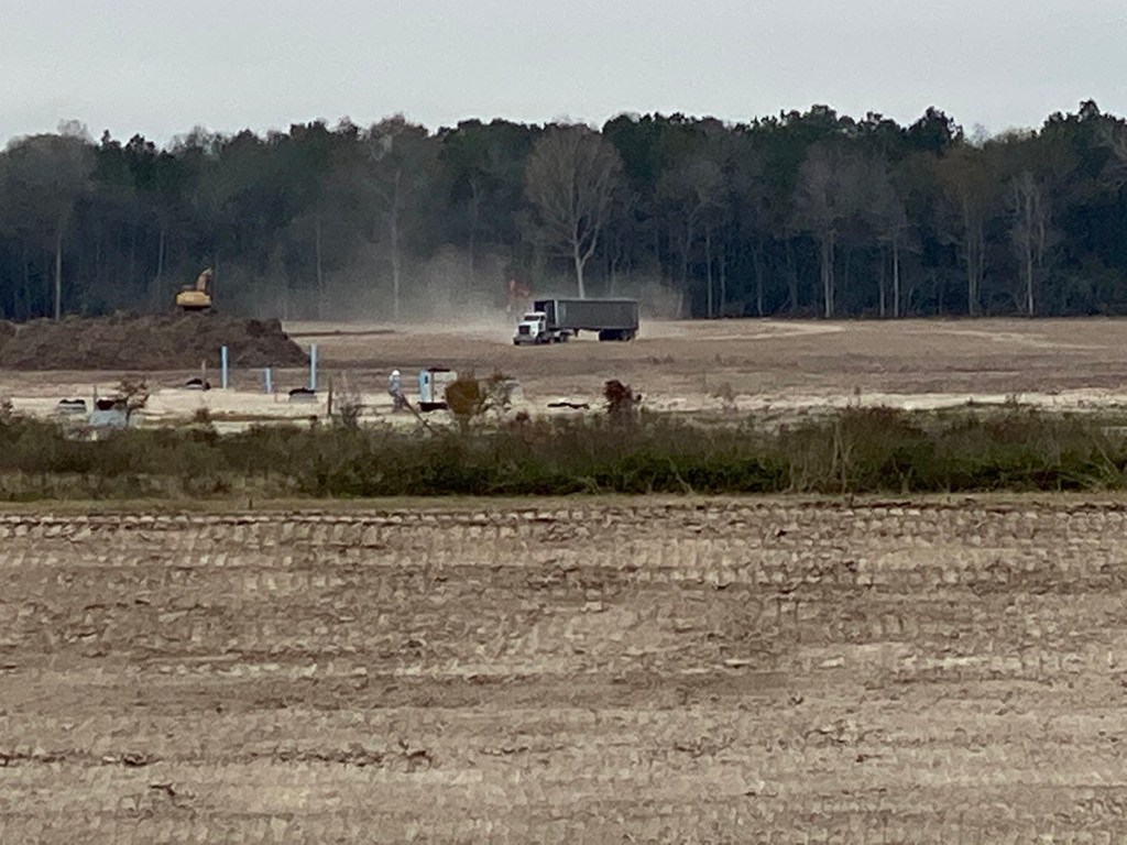
Instead of accelerating completion of detention ponds on Woodridge Village as Perry Homes promised, the company appears to have pulled all excavation equipment from the site. Contractors who were supposed to have been working on detention pond N-1 have gone…BEFORE they finished S2 and BEFORE they finished a berm sealing off the southern portion of the site at Fair Grove Drive.
Equipment Left Site Instead of Beginning On Next Pond
Perry Homes had promised in its letter to accelerate construction, but this will slow it down – if they ever return. The only work being done Friday? Removal of some dead tree piles on the northern portion of the site.
Jeff Miller took all the pictures and videos below on Friday and Saturday. He also monitored work on the site and provided this scouting report.
Looking south toward Taylor Gully and the Harris County Line along the eastern embankment of the S2 detention pond.The channel along the eastern portion of Taylor Gully is now lined with concrete. The spillway into the S2 detention pond has been widened and smoothed. The S2 detention pond is behind the camera position. Looking East.Looking west across S2 detention pond. The dirt that eroded into the pond has been scooped back up onto the banks and compacted.Still no grass on the banks, however, so it could all wash back in with the next big rain.Looking north. The grassy area in the background was supposed to have contained the N3 detention pond. However, contractors have simply excavated a channel from the northern section directly into Taylor Gully so now runoff can accumulate even more quickly.Contractors widened and concreted the Taylor Gully channel along the eastern side of Woodridge Village. But they left the most vulnerable part of the channel without concrete. At the end corner by the telephone poles, water comes from the left. But no concrete protects the area where the water makes a sharp 120 degree turn. Expect water to erode behind the concrete and peel it away in the next big rain.
Woodridge Village Section One Now a Virtual “Ghost Town”
This weekend, Woodridge Village Section One looked like a ghost town, not a bustling construction site with people working against a deadline.
Heavy construction equipment used to be parked by dumpster in the background. Now it’s nowhere on the property. Looking south. Another view of the same area that held construction equipment. It’s all gone and the berm sealing the site off from Fair Grove Drive is missing.
Still Removing Dead Trees/Mulch on Northern Section
On Friday, only smaller equipment turning tree piles into mulch remained.
Perry Homes Intentions Now a Mystery
As of Sunday morning 12/22/2019, no equipment actually working on construction could be seen on the site. The excavators and dump trucks parked at Fair Grove for months have been removed.
Perry Homes is NOT accelerating completion of detention ponds as it promised the City of Houston.
Instead, Perry Homes has thrown a curtain of silence around this job. It’s hard to know what their intentions are. At this point, Perry Homes’ lawyer J. Carey Gray has as much mud on his face as Elm Grove residents had in their homes.
The only thing we can say with certainty: Lowering flood risk for the people of Elm Grove does not seem high on Perry Homes’ priority list.
For Sale And For Lease Signs Serve as Christmas Yard Decorations
Meanwhile, a drive down Shady Maple or Village Springs, the two streets that border Taylor Gully, revealed residents’ attempts to salvage Christmas from the chaos of floodwaters. Dumpsters and debris still line the streets. Some people still live in trailers in their driveways. No apple cider around the hearth for them. They’ll be lucky to find space for a table top Christmas tree. For Sale and For Lease signs outnumber Christmas yard decorations ten to one.
On a street called Right Way in North Kingwood Forest, I found nine For Lease signs in a row. Sad reminders of Imelda and Perry Homes.Only three months ago, these homes were filled with families who flooded for the second time.
Kathy Perry Britton just added another credit to her resume, “The CEO Who Stole Christmas.”
Posted by Bob Rehak on 12/22/2019with reporting and images by Jeff Miller
845 Days since Hurricane Harvey and 94 since Imelda
The thoughts expressed in this post represent opinions on matters of public concern and safety. They are protected by the First Amendment of the US Constitution and the Anti-SLAPP Statute of the Great State of Texas.
https://i0.wp.com/reduceflooding.com/wp-content/uploads/2019/12/IMG_0679.jpg?fit=1200%2C900&ssl=19001200adminadmin2019-12-22 12:09:152019-12-22 12:58:38Perry Homes Pulls Excavation Equipment From Woodridge Village Before Finishing Detention Ponds
The attorney general has had production at the Triple PG mine on Caney Creek shut down and the breaches in the mine’s dikes closed since early November. Also, the Texas Concrete mine in Plum Grove on the East Fork closed. And the TCEQ is forcing them to fix breaches and replant exposed areas before abandoning the mine. It could just be a coincidence, but water clarity on the East Fork and Caney Creek have improved to a shocking degree with both of the major mines out of action. See below. Said Kingwood resident John Knoerzer, “This is the clearest I’ve ever seen the East Fork.”
Photo taken by John Knoerzer on East Fork at East End Park on 12/20/2019.
It’s not Cozumel, but it’s far better than the opaque brown liquid we had.
Return of Eagles
Resident Josh Alberson reports that he’s seen cormorants, pelicans and bald eagles return to the East Fork and Caney Creek. “They were feasting on the white bass.” Says Alberson, “Last Sunday, we saw more birds than we had every seen working. It was National Geographic worthy, but I couldn’t get close enough to get any quality pics or video.” He attributes all the birds to both the bass and the clarity of the water. “It helps the birds spot the prey,” he says.
Only problem: there’s so much sand in Caney Creek that it’s hard to boat upstream. Josh Alberson informs me that his jet boat got stuck on a giant sand bar immediately downstream from the Triple PG mine. Boats with propellers can’t get through at all, he says.
Please Help Document Wildlife and Water Clarity
It seems to me that this change, if it is permanent, is important to document. Any boaters or jet skiers who can make it upstream, please send pics through the submissions page on this web site.
Posted by Bob Rehak on 12/21/2019
844 Days after Hurricane Harvey and 93 since Imelda
The thoughts expressed in this post represent opinions on matters of public concern and safety. They are protected by the First Amendment of the US Constitution and the Anti-SLAPP Statute of the Great State of Texas.
https://i0.wp.com/reduceflooding.com/wp-content/uploads/2019/12/Clear-Water.jpg?fit=1200%2C900&ssl=19001200adminadmin2019-12-21 15:53:042019-12-22 07:49:16East Fork Water Shockingly Clear with Mines Closed
As we enter 2020, keep your eyes on these stories.
Elm Grove Lawsuits and Mitigation
In 2019, Elm Grove flooded twice with runoff from the Perry Homes/Woodridge Village development in Montgomery County. Hundreds of homeowners sued Perry Homes’ subsidiaries (PSWA and Figure Four Partners) and their contractors.
On 12/17/19, attorney’s for the plaintiffs filed a fourth amended petition. Since the original filing, plaintiffs have named Double Oak Construction and Texasite LLC as additional defendants.
The judge set a jury trial date for July 13, 2020. To date, Perry Homes has done nothing to reduce the threat of flooding from their job site.
The 268-acres clear-cut acres that contributed to Elm Grove Flooding.
That brings us to the subject of mitigation.
What can be done to restore the safety of residents?
Perry Homes has demonstrated no interest in reducing the threat to downstream flood victims.
Protecting homeowners will require massive intervention from an outside source. But who? And how?
I recently learned of two new developments in the Ben’s Branch watershed.
A developer intends to build 18 acres of apartments where the woods adjacent to the new St. Martha Church now stand.
Another developer intends to build hundreds of homes on tiny lots on an 80-acre site just north of St. Martha’s.
These two projects represent dozens of others gobbling up farm and forest land in southeast Montgomery County.
This drainage ditch feeds into Ben’s Branch at Northpark Drive. The 18 acres of trees on the other side of the ditch could soon become apartments.
Businesses such as the St. Martha School and Kids in Action already flooded twice this year. So did dozens of homes along Ben’s Branch.
Additional upstream development has the potential to make flooding even worse. This is like death by a thousand cuts. Residents just don’t have the time or energy to monitor each development to ensure that owners follow rules and regulations for wetlands, floodplains, drainage, etc. Neither evidently does Montgomery County. Which brings us to…
Montgomery County Standards and Enforcement
Montgomery County competes for development by touting its lack of regulations. That’s a huge problem for downstream residents.
Montgomery County still bases flood maps on data from the 1980s.
Large parts of the county remain unmapped for flood hazards.
The County last updated its Drainage Criteria Manual in 1989.
Developers ignore many provisions within it.
County Commissioners voted to leave loopholes open that allow developers to avoid building detention ponds.
The County even paid an engineering company to investigate itself for its role in the Elm Grove Disaster.
You get the idea. If you thought some benign government entity watched over new developments to protect downstream residents, think again. Below you can see the 80-acre site I mentioned above.
Source: USGS National Wetlands Inventory.
Note how it was covered in wetlands. Developers did not ask permission from the Corps to remove them. They just decided on their own that they didn’t need to ask.
Below, you can see how virtually half the site is in a flood zone or floodway.
Here’s how it looks in Google Earth. Developers have already cleared the site.
Developers intend to build high-density homes in the floodplains. They will also build their detention pond in the floodway. Those hazard areas will likely expand when and if the County incorporates new Atlas-14 data into their flood maps.
Layout for Brooklyn Trails development in Montgomery County
None of this seems to bother the leadership of Montgomery County. And that’s a bigger problem than any one development.
In 2020, expect more focus on the decision-making process and decision makers who have created a permissive culture of indifference to flooding problems.
Sand Mines
Sand mines operate so closely to the San Jacinto that their walls frequently break and pour polluted process water into the drinking water for 2 million people. If they get caught, they pay a small fine and continue operating with impunity.
Left: Liberty Materials Mine in Conroe that undercut five pipelines carrying highly volatile liquids. Center: Triple PG mine in Porter where erosion during Imelda exposed one natural gas line and threatens 5 more HVL pipelines. Right: Another Liberty Materials mine that allegedly dumped 56 million gallons of white goop into the West Fork.
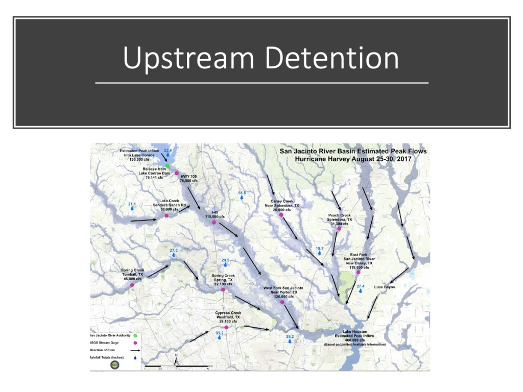
Upstream Detention
During Harvey, the release of 80,000 cubic feet per second from Lake Conroe added to downstream flooding. The goal: to find enough upstream detention capacity to help offset future releases. The San Jacinto River Basin Study will examine that possibility. It’s unlikely that one reservoir will provide enough capacity. However, multiple smaller reservoirs may.
Luckily, State Representative Dan Huberty sponsored legislation that allocated another $30 million. The Harris County Flood Bond allocated $10 million. The City of Houston allocated $6 million. Plus two more grant requests are still pending that could increase the total even more. And a disposal site for the material has already been permitted.
Mouth Bar of the West Fork. Photo taken 12/3/2019.
Last week, Harris County commissioners voted to proceed with additional dredging. Project managers are studying the most cost effective ways to proceed. We should see more dredging soon.
This money could also be used on the growing mouth bar of the East Fork.
State Highway 99 Extension
The extension of the Grand Parkway (State Highway 99) east and south to I-10 will open up vast new expanses of forest and farmland to high density development. The biggest threat will be to the East Fork watershed as construction moves through southeast Montgomery County and the northeast tip of Harris County into Liberty County.
Eastward clearing for SH99 has reached Caney Creek near Lake Houston Park.
Those are my predictions for the biggest stories of 2020. There’s a lot of good news in the forecast and much to remain vigilant about. Life seems to be a constant struggle between those who would increase and decrease our margin of safety when it comes to flooding.
Posted on 12/21/2019 by Bob Rehak
844 Days after Hurricane Harvey
The thoughts expressed in this post represent opinions on matters of public concern and safety. They are protected by the First Amendment of the US Constitution and the Anti-SLAPP Statute of the Great State of Texas.
https://i0.wp.com/reduceflooding.com/wp-content/uploads/2019/12/Slide14.jpeg?fit=1200%2C900&ssl=19001200adminadmin2019-12-21 12:30:522019-12-21 14:37:12Big Stories to Watch in 2020
Tuesday, at the open house in Kingwood to review work to date on the San Jacinto River Basin Master Drainage Plan, the Plan task force members showed two very interesting posters. Together, they show where the water came from during Harvey and the extent of inundation. They also show the amount of rainfall in different areas throughout the watershed.
When you put these two maps together, one high-level message screams through:
1.5 to 3.5 feet of rain fell over 2,885 square miles. That’s an area bigger than Delaware. And it all drained toward Lake Houston.
Watersheds Within River Basin
Looking at these posters gives you an appreciation for how complex flood forecasting can be, especially for areas like Kingwood where so many watersheds converge. The river basin map below shows the number of square miles drained by each of the major tributaries. The upper right corner inset map shows the same tributaries mapped over the major roads, counties and cities in the region to help you place the streams.
The second poster shows the extent of inundation along each of those major tributaries during Harvey. The upper right inset map shows rainfall across the region. Note how the rainfall was heavier toward the lower and eastern parts of the river basin. As water came downstream and the rain kept falling in those areas, the floodwater just kept building higher and higher.
How Local Factors and Channel Hydraulics Come Into Play
The maps also reveal much about smaller areas within the watershed.
Matt Zeve, Deputy Executive Director of Harris County Flood Control, has studied channel hydraulics for more than 20 years. He emphasized flooding in The Woodlands and Cypress did NOT flood because of water backing all the way up from Lake Houston. Lowering water in Lake Houston faster will not prevent flooding that far upstream, he says. A wide variety of local conditions govern upstream flooding, such as:
Rainfall rate, volume and location
Time of accumulation
Channel width/depth
Gradient
Flatness of terrain
Blockages
Rate and timing of runoff
Time of year
Amount of vegetation vs. impermeable cover
Soil type
Ground saturation and more.
This rainfall and inundation map clearly shows the effect of some of these factors. Notice, for instance, the three pockets of heavy flooding at the west end of Cypress Creek on the left. Also notice how the flooding narrows downstream toward the right. There are a several things going on here, according to Zeve.
The area that flooded so badly was extremely flat. The area used to contain rice paddies. Farmers made the land even flatter.
That area also received more rainfall. Note the small pocket of orange on the rainfall inset map over the area that flooded so badly on Cypress Creek.
As you move east on Cypress Creek, the flooded area gets less wide. That’s because the channel gradient increases. The creek therefore creates a deeper channel and the floodplain narrows.
Rice fields surrounded the headwaters of Cypress Creek in 1989.
As you look at these maps, apply your knowledge of local conditions to see if you can explain similar anomalies.
For Future Reference
These maps still exist in draft form. The river basin survey is only half complete. The maps may change before completion of the study.
For easy reference in the future, I will post the high-res PDFs under the Hurricane Harvey tab in the Reports page.
Posted by Bob Rehak on 12/20/2019
843 Days since Hurricane Harvey
https://i0.wp.com/reduceflooding.com/wp-content/uploads/2019/12/EX03_HarveyCalibration-copy.jpg?fit=1200%2C1200&ssl=112001200adminadmin2019-12-20 16:21:242019-12-20 18:30:29Where the Water Came From During Harvey and Extent of Inundation