Mouth Bar Dredging Begins
It appears that dredging of the mouth bar of the San Jacinto West Fork has officially begun. Two weeks ago, I reported that the Great Lakes dredge had maneuvered into position. Then this weekend, residents started sending me pictures taken from the river showing equipment in operation.
Mouth Bar Imagery from RD Kissling
RD Kissling, a Lake Houston area resident and geologist, who first helped bring the mouth bar to the public’s attention sent me the photo and video below last week. “The dredge is up and running,” he said.
The image with the canoe below, Kissling said, “This is me standing in shin deep water about 200 yards south of the exposed mouth bar, looking north towards the bar and Scenic Shores. There is another small channel about 20 yards south of me then the bar shoals again.”

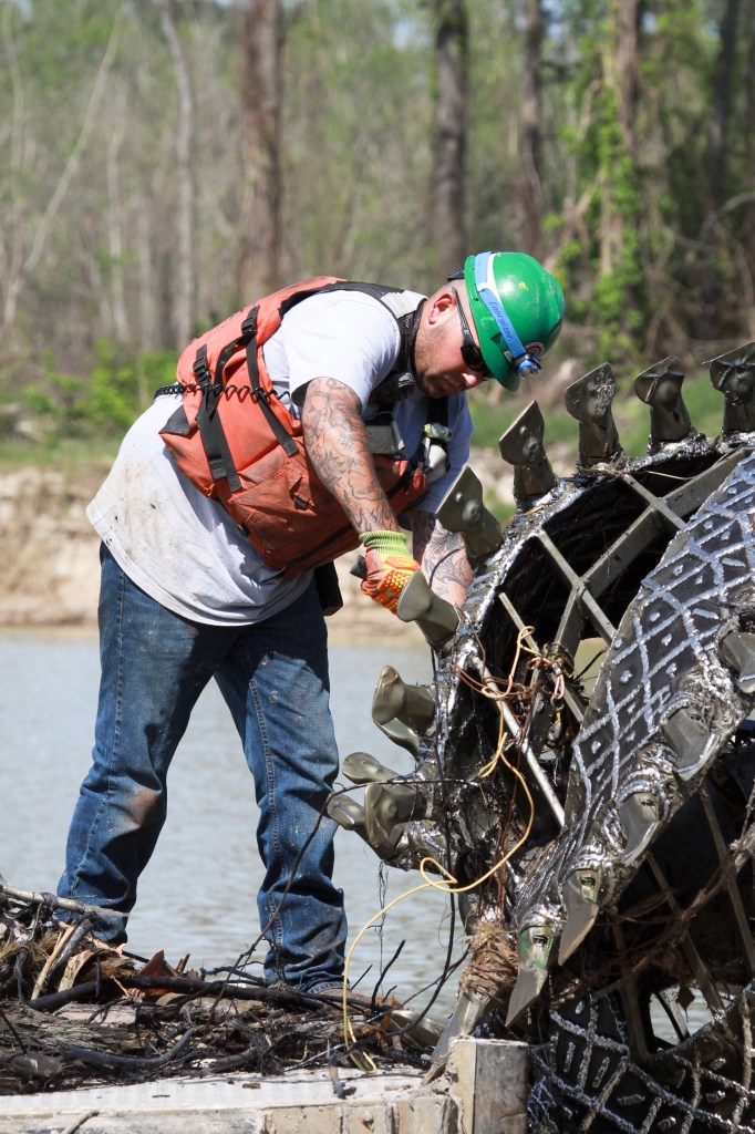
Mouth Bar Images from Today Shot by Jeff Kristoff
Then Jeff Kristoff, a Kingwood resident, sent me the pictures below today. They show an excavator on the upstream end of the bar and dredging equipment immediately south of the bar. It appears there may be two excavators breaking up vegetative growth and sediment. Farther upstream, near River Grove Park, dredgers reportedly ran into submerged logs that had been covered by sand.


Ultimate Plans Still Not Announced Yet
Exactly where or how much the Corps and its partners plan to dredge has not yet been announced. The Corps last issued a press release for the project on June 10, three weeks ago, and has not yet responded to a Freedom-of-Information-Act request for the dredging plans.
Because it’s hard to believe that the U.S. Army would move on a project this large without a plan, I can only conclude that all parties have not yet reached an agreement on volume and a permit for placement of the sediment.
For the time being, it looks as though the Corps will use Placement Area 2 on Sorters Road…at least initially. Pumping ALL of the sediment 10 miles upstream would hike the cost hugely because it would require at least 5 booster pumps. Each uses 1000 gallons of diesel per day.
For speculation on where and how much they might dredge, see this post.
Posted by Bob Rehak on July 4, 2019, with images and video from RD Kissling and Jeff Kristoff
674 Days since Hurricane Harvey