The presentation begins with a history of the relationship between the Army Corps and HCFCD dating back to 1937. It references past joint projects such as work on the Addicks and Barker Reservoirs; and Brays, White Oak, Little Vince, Cypress, Greens and Sims Bayous.
It also references projects not yet completed such as work on White Oak and Hunting Bayous, and Clear Creek. Finally, it looks forward to future collaboration on Buffalo Bayou, Halls Bayou and a County Wide-Study that “lifts up and empowers our diverse communities to thrive.”
The intro contains graphics that summarize:
Damage during Hurricane Harvey
Atlas-14 rainfall vs previous estimates
Current and Active Army Corps projects
A county-wide map of “Recently flooded” (from Harvey) structures overlaid on a social-vulnerability map
The leave-behind then makes three “asks” corresponding with each of the three major projects.
Buffalo Bayou and Tributaries Resiliency Study
The first ask is for help “finding the right solution for Addicks and Barker Reservoirs.” It talks about managing residual risk and liability. Specifically, it asks for support through the completion of the Corps’ Buffalo Bayou and Tributaries Resiliency Study.
It alludes to policies and processes impeding needed progress. Then it says, we must blaze a trail for a new equitable flood risk management paradigm.
An engineer familiar with Buffalo Bayou told me that the study had been cancelled at one time because of a poor Benefit/Cost Ratio. It wasn’t because, as you often hear, that home values were low. It was because land acquisition costs were so high. Possible workarounds: several proposed “innovations” including:
Flood tunnels
A comprehensive benefits framework that includes more than a strict benefit/cost ratio.
“Emphasis on community resiliency, environmental justice, and climate change adaptation.”
The last update of this study on the Corps’ website is from late 2020. The final report has not yet been released. This post from 2020 summarizes the findings of the interim report.
County-Wide Section 203 Study
Section 203 of the Water Resources Development Act was amended to let non-Federal sponsors conduct feasibility studies that serve as the basis for authorization of new water resources projects, such as flood tunnels. But acceptance of the results is at the discretion of the ASA (CW). One objective of the presentation: to get the ASA(CW) to partner Harris County on a County-wide flood risk study.
The county pitched the partnership as:
A potential “pilot study for Justice40”
Climate change preparedness
Empowering vulnerable communities to withstand and recover from flood events.
Justice40 is a Biden initiative, announced within his first few weeks in office. It uses every lever at his disposal “to advance environmental justice and spur economic opportunity for disadvantaged communities. The “40” refers to Biden’s promise to deliver at least 40 percent of the overall benefits from Federal investments in climate and clean energy to disadvantaged communities. One of the priorities: mitigation initiatives that reduce or eliminate the risk of repetitive flooding.
Halls Bayou Section 118 Study
According to the presentation, the Federal government had a project to study flood-risk management on Halls Bayou from 1990 to 2016 when it was “de-authorized.” The county wants to restart it. Section 118 refers to “Pilot programs on the formulation of Corps of Engineers’ projects in … economically disadvantaged communities.”
Harris County wants the Corps to include Halls on its list of ten nationwide pilot studies for such communities. HCFCD points out that Halls has the highest percentage of Low-to-Moderate Income residents of any watershed in the county (71%). Halls has a poverty rate of 28% and a social vulnerability index of 0.85 out of 1.00. Halls also has frequent, severe, repetitive flooding.
At one time, HCFCD cancelled Halls’ Bayou studies because they all came back with Benefit/Cost Ratios below 1.0. That means costs exceeded benefits. HCFCD hopes to restart those in 2022. Section 118 gives the ASA (CW) a way to apply other criteria that compensate for a low BCR in disadvantaged areas.
Posted by Bob Rehak on 7/7/22
1773 Days since Hurricane Harvey
https://i0.wp.com/reduceflooding.com/wp-content/uploads/2022/07/20220707-Screen-Shot-2022-07-07-at-12.32.19-PM-2.jpg?fit=1200%2C737&ssl=17371200adminadmin2022-07-07 18:31:582022-07-07 18:33:16HCFCD Asks for Army Corps Help with Tunnels, Halls Bayou, Addicks/Barker
Coastal Water Authority (CWA) recently posted minutes from its May 11th board meeting that reveal a possible new direction for adding more flood gates to the Lake Houston Dam. After months of discussing various crest gate alternatives to increase the release capacity of the dam, engineers will now focus on examining two tainter gate alternatives. One would add six tainter gates, the other twelve.
Neither alternative would modify the concrete portion of the spillway, as crest gates would. Black & Veatch, the engineering firm in charge of the project, will explore adding the tainter gates in the earthen embankment to the east of the existing spillway. See below, upper right.
Looking ENE at Lake Houston Dam. Black and Veatch is now exploring adding tainter gates to the earthen portion of the dam in the upper right.
The eastern embankment is a solid earthen area 2800 feet long east of the spillway and existing gates (see upper right of photo above). Water cannot get over it in a storm because it is so much higher than the spillway. By adding various structures in this area, engineers could widen the current spillway capacity, allowing release of more stormwater.
Tainter gates rotate up from a central pivot point. Crest gates rotate down from a bottom hinge, like a piano lid.
Minutes from May CWA Board Meeting
Item IV(B) on Page 3 of the May 11, 2022, minutes states, “…CWA, City of Houston (COH), and Black and Veatch (B&V) met on April 14, 2022. During that meeting the COH requested that an alternate gate location to the east of the existing gate structure be further [emphasis added] evaluated.”
Following the meeting, B&V developed a scope of work to update the gate concepts and construction costs for this area. The COH provided comments and B&V modified its proposal. B&V reportedly began work on the new direction by June 1.
Additional Funding Needed
Each of the new alternatives would require additional funding; neither fit within the existing budget, according to the CWA staff. COH Public Works will pay for the new evaluation.
Wayne Klotz, P.E. and President of the CWA Board, reminded everyone present that COH owns the dam and is the FEMA grantee for this project, while CWA works for and takes direction from COH.
Minutes from the June CWA meeting have not yet been posted. The last post about gates on the COH District E website was almost a year ago on July 8, 2021.
7/4/22 Screen Capture from District E Website.
However, City Council member and Mayor Pro Tem Dave Martin did take questions on the project at an April 2022 community meeting. At the time, Martin expected to have a final answer on gates in a “September-ish” time frame.
Currently, the release capacity of tainter gates on the Lake Conroe Dam is 15X greater than those on the Lake Houston Dam (150,000 cubic feet per second (CFS) vs. 10,000 CFS.)
Concept Studied and Rejected Once Already
Adding gates to the eastern embankment was one of the original concepts evaluated. (See Column 5, Offsite Alternative #2, Column 5, Page 4.) But engineers focused on adding crest gates instead, largely because the total estimated costs for adding tainter gates at that time exceeded $90 million for a $50 million budget. However, the Army Corps also had environmental concerns about adding gates to the eastern embankment.
FEMA initially gave the City three years to complete the project (18 months for engineering and 18 for construction). Engineering began in April 2020.
No other details about May’s change in direction have been released to my knowledge.
Posted by Bob Rehak on 7/4/2022 based on minutes from the May CWA Board meeting
1770 Days since Hurricane Harvey
https://i0.wp.com/reduceflooding.com/wp-content/uploads/2022/07/20200911-RJR_1521-2.jpg?fit=1200%2C800&ssl=18001200adminadmin2022-07-04 15:33:252022-07-04 16:13:48CWA Exploring Alternate Plan for Adding Lake Houston Dam Gates
The damages phase of the Upstream Addicks-Barker class-action lawsuit over Hurricane Harvey flooding concluded Friday, 6/11/2022. Earlier, Judge Charles F. Lettow ruled that the Army Corps was liable for damages. The question being decided now is “How much will they get?” We don’t yet have that answer, but should before the end of the year.
Flooded homes inside Addicks Reservoir during Harvey but still outside even today’s 100-year floodplain.
Basis for Claims
After Hurricane Harvey, people and businesses both upstream and downstream of the Addicks and Barker Reservoirs on Houston’s west side sued the Army Corps. Plaintiffs in both cases alleged that the Army Corps’ operation of the dams flooded their homes and constituted a taking of their property without compensation. The Fifth Amendment of the U.S. Constitution prohibits that.
“No person shall be … deprived of … property, without due process of law; nor shall private property be taken for public use, without just compensation.”
However, the Upstream and Downstream cases also have important differences. Upstream, the Corps did not own all the land inside the U-shaped reservoirs. Worse, the Corps permitted developers to build homes and businesses inside the reservoirs on land that remained in private hands. The Corps did not anticipate it all flooding based on storms they had studied going back to the 1890s. Yet the Corps still built the walls taller and longer than it needed to hold anticipated floods.
When Harvey came along, the water in the reservoir backed up onto that private property and flooded hundreds of homes.
Lawyers for the flooded property owners asserted that the federal government cannot use private property to store federal floodwaters without providing compensation. The judge agreed.
Although the trial portion of the damage phase just concluded, the case is not yet over. McGhee, Chang, Landgraf & Feiler, one of the law firms representing plaintiffs in the class-action suit, said they must still submit post-trial legal briefings. Then they will make final closing arguments in Washington D.C. in a few months. “We expect a decision to be rendered by the Court thereafter – probably sometime in late fall/winter,” said a press release by the firm.
Exponential Growth, Larger Storms, But No Mitigation
After reading the 46-page decision, I gained a better grasp of the history of the dams and the nature of the claims.
The Corps built the dams much higher than they needed to hold a 100-year flood based on what they knew at the time.
But the Corps did not purchase all land inside the reservoirs. They left private property outside the area expected to flood. At the time the dams were constructed, that land was used for ranching and rice farming.
If the land flooded, reasoned the Corps, not much damage would result. But then came Houston’s exponential growth in the 1950s. Those ranchers and rice farmers sold their land to developers. And developers started to build inside the reservoir.
Then the Corps realized that the storms on which it based the reservoirs’ designs (including a storm from the 1890s) were smaller than storms hitting the Houston area in the modern era. But by then, it was too late.
When the Corps realized future floods would likely invade homes, it launched an awareness program and held some public meetings. But the judge felt that information didn’t filter down to most homebuyers.
Also, the Corps took no concrete steps to reduce flood risk when it realized the severity of the problem. Worse, the Corps continued to issue permits and authorizations for more developments.
To sum up 46 pages in a sentence, “The Corps knew it had a problem and did nothing to fix it.” (That’s my takeaway, not the judge’s language.) The Corps remained focused on its primary objective – preventing downstream flooding.
Downstream Focus Looms Large in Upstream Decision
Said Judge Lettow, “Equipped with the knowledge that storms of the design-storm magnitude were probable, the Corps did not stray from its primary objective to prevent downstream flooding (indeed, it probably could not), even when it knew that could well mean impounding water on private property.”
Lettow cites a 2012 Water Control Manual which the Corps followed during Harvey. It instructs the Corps to operate the dams in a manner consistent with their original purpose: to protect downstream property by impounding water in upstream reservoirs. It states “…operate the reservoirs in a manner that will utilize to the maximum extent possible [Emphasis added] the available storage to prevent the occurrence of damaging stages on Buffalo Bayou.”
Knew Larger Floods Probable
According to the judge, the Corps continued to follow that policy even though it understood that rainfall events – larger than ones they designed the dams around – were “probable, rather than merely possible.”
Lettow also found it “undisputed that plaintiffs did not know their properties were located within the reservoirs and subject to attendant government-induced flooding.”
Government Planned for Years to Impound Floodwater on Private Property
Said one hydrologist who reviewed a detailed history of the Corps’ decision making, “The Corps of Engineers did NOT buy the entire area they knew would be inundated if Addicks and Barker reservoirs were at peak storage capacity.”
Judge Lettow said, “The government had made a calculated decision to allow for flooding these lands years before Harvey, when it designed, modified, and maintained the dams in such a way that would flood private properties during severe storms. Defendant cannot now claim that this harm was unavoidable when it planned for years to impound floodwaters onto plaintiffs’ properties.”
The Corps made the best decisions it could with the information AVAILABLE at the time. But as we all know, things change! And that’s what worries me most about this case.
Right now, developers are building projects all around the region based on flood maps that will soon be replaced.
The thoughts expressed in this post represent opinions on matters of public concern and safety. They are protected by the First Amendment of the US Constitution and the Anti-SLAPP Statute of the Great State of Texas.
https://i0.wp.com/reduceflooding.com/wp-content/uploads/2022/06/Flooded-Homes-Addicks-Reservoir.jpg?fit=1200%2C765&ssl=17651200adminadmin2022-06-11 16:03:182022-06-11 21:44:24Upstream Addicks-Barker Trial Concludes, But No Ruling Yet on Damages
A myth being promulgated in Harris County Commissioners Court and certain low-to-moderate income (LMI) watersheds these days goes something like this:
The FEMA Benefit/Cost Ratio (used to rank grant applications for flood-mitigation projects) favors high-dollar homes.
That disadvantages less affluent, inner-city neighborhoods compared to more affluent suburbs.
Therefore, less affluent neighborhoods get no help and the more affluent neighborhoods get it all.
This post busts that myth. But it won’t stop activists from demanding more “equity.”
If you look at all flood-mitigation spending in Harris County since 2000, on average, less affluent watersheds already receive 4.7X more partner funding per watershed than their more affluent counterparts.
Analysis of data obtained via FOIA request
Myth Ignores Other Factors, Frequently Leaps to Wrong Conclusions
Like much of political discourse these days, the myth focuses on a narrow sliver of truth, ignores other factors, and frequently leaps to the wrong conclusions.
An analysis of Harris County Flood Control District data going back to the start of this century shows how far off the myth can be.
Today, I focus on partner grants because they represent such a huge percentage of the flood-bond budget and because there is so much misinformation floating around about them.
And I will look at partner funding from the standpoint of outcomes, not just processes (as in the myth).
Methodology for Analysis
For this analysis I obtained Harris County Flood Control District spending data between 1/1/2000 and 9/31/2021 via a Freedom of Information Act (FOIA) request. I requested the data by watershed, decade, pre-/Post Harvey, source of funding (local vs. partner), and type of activity (i.e., engineering, right-of-way acquisition, construction and more). I cross-referenced this with other data such as flood-damaged structures, population, population density, and percentage of low-to-moderate income (LMI) residents.
When considering grants, the percentage of LMI residents in a watershed takes on special significance. Department of Housing and Urban Development (HUD) grants often require high percentages of LMI residents in the area under consideration.
In the charts below, you will see references to watersheds with LMI populations above and below 50%. Above 50% means more than half the residents in the watershed have an income LESS THAN the average for the region. Below 50% means more than half the residents earn more than the regional average.
Harris County has 23 watersheds. Eight have LMI percentages above 50% (less affluent). Fifteen have LMI percentages below 50% (more affluent).
When reviewing the charts below, pay particular attention to the italicized words: Total, Partner, and On Average. They represent three different ways to look at the same question: Do housing values disadvantage an area when applying for grants?
For this analysis, I focused only on the long term, since decisions on more than a billion dollars in flood-bond grants are still outstanding.
FOIA Analysis Contradicts the Popular Myth
One of the first things you notice when you look at watersheds above and below 50% LMI, is that the eight least affluent watersheds have gotten more than 60% of all dollars actually spent on flood mitigation since 2000.
Less affluent watersheds, despite being half as numerous, received 60% of all dollars since 2000.
Because the allegation was that partnership grants favored affluent areas, I then analyzed whether partner dollars went mostly to affluent or less-affluent watersheds. The answer is less affluent…overwhelmingly.
More than 70% of all partner dollars in the last 22 years went to the eight less-affluent watersheds.
The last observation by itself is telling. But because of the widely different number of watersheds in each group, I also wanted to calculate the average partner dollars per watershed in each group. This blows the “rich neighborhoods get all the grants” argument to pieces. Less affluent watersheds got, on average, 4.7X more.
Dividing the total partner dollars by the number of watersheds in each group shows that less affluent watersheds average 4.7X more than affluent ones.
This busts the myth. But digging even deeper into the data reveals two things: wide variation between sources of funding and withinLMI groupings.
USACE Funding Skews Partner Totals
The U.S. Army Corps of Engineers (USACE) accounts for much of the partner funding. USACE has provided significant funding for projects in the Sims, Brays, White Oak, Hunting, and Greens Bayou watersheds. The Clear Creek watershed will also soon see work on a new USACE project. USACE has completed its planning process and proved positive benefits to national economic development. That made projects worthy of Federal investment.
Halls Bayou: Digging Deeper
The Halls Bayou watershed also went through the USACE planning process, but the results did not show enough flood-damage-reduction benefits to outweigh the costs of the proposed projects. Thus, the Halls Bayou watershed currently has no USACE-funded projects.
Despite that, Halls has received more partner funding than 16 other watersheds since 2000. Only two watersheds in the affluent group of 15 received more partner funding. See the table below.
Total and partner spending by watershed since 2000 arranged in order of highest to lowest LMI percentages.
USACE also evaluated the more affluent Buffalo Bayou; results showed that costs outweighed the flood-damage-reduction benefits there.
Despite Halls having the highest percentage of LMI residents in Harris County, Halls has received more total funding and 2.5X more partner funding than Buffalo Bayou in the more affluent group.
FEMA Considers More than Home Values, Not All Grants Come From FEMA
While it’s true that FEMA considers housing values as a factor in benefit/cost ratios, benefit/cost ratios (BCRs) also consider factors such as:
The number of structures damaged
Threats to infrastructure
Proximity to employment centers
Need for economic revitalization
Percentage of low-to-moderate income residents in an area
Number of structures that can be removed from the floodplain by a project.
USACE funds dozens of different types of flood-mitigation programs. Many support national defense, the national economy, strategic interests, the environment, commerce and navigation.
So don’t settle for soundbites. They often mislead.
Posted by Bob Rehak on 12/30/2021
1584 Days since Hurricane Harvey
https://i0.wp.com/reduceflooding.com/wp-content/uploads/2021/12/Screen-Shot-2021-12-29-at-4.53.47-PM.png?fit=1366%2C740&ssl=17401366adminadmin2021-12-29 21:28:052021-12-30 14:37:20Equity Myth Buster: “Rich Neighborhoods Get All the Flood-Mitigation Funding”
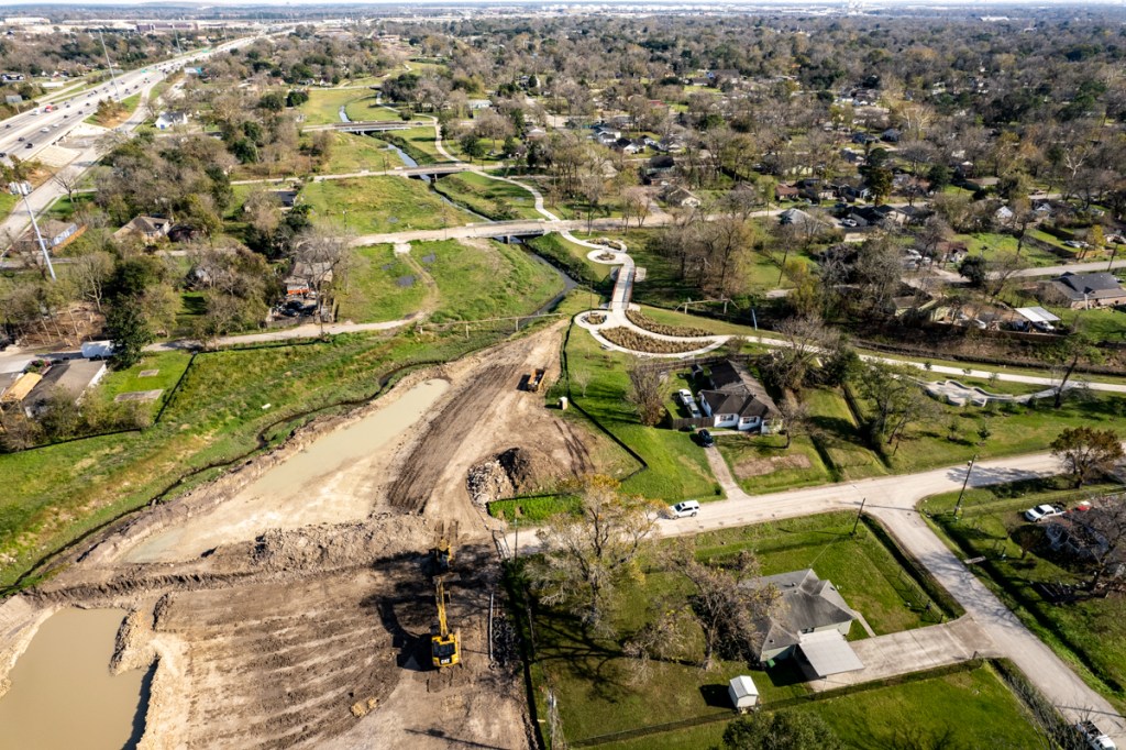
Widening of Hunting Bayou, one of the poorest and most flood-damaged watersheds in the county, is kicking into high gear.
Annual Rate of Spending Almost Quadruples since Harvey
According to data obtained as part of a Freedom of Information Act (FOIA) request, Harris County Flood Control District and its partners (mainly the Army Corps and City of Houston), spent $44 million on flood mitigation in the Hunting Bayou watershed between 1/1/2000 and Hurricane Harvey.
That averaged $2.4 million per year for those 18 years. However, in the 4 years since Harvey, HCFCD has spent $37 million – more than $9 million per year.
That rate of spending averages 3.75X higher after Harvey than before.
HCFCD Spending Data Obtained via FOIA Request
Here’s a breakdown.
From FOIA Request.Hunting Bayou flood-mitigation expenditures by time period and category since 1/1/2000 through end of third quarter 2021.
Focus of Current Construction Activities
The upstream portion of Hunting Bayou parallels the south side of Loop 610 for most of its length. Where North Loop 610 turns south, Hunting cuts under it between McCarty and Wallisville Roads. From there it continues east. It then turns southeast at San Pedro Street and eventually joins Buffalo Bayou and the Ship Channel.
Note width of floodplains in red box. HCFCD is now widening Hunting between the left and right boundaries of the box.From Harris County Flood Education Mapping Tool. Blue = 100-year. Green = 500-year floodplain.
The Hunting Bayou watershed has the second highest percentage of low-to-moderate income (LMI) residents in the county (69%) after Halls Bayou (71%) immediately to the north.
Hunting also is heavily industrialized with rail yards, tank farms, manufacturing, and shipping companies. The highest points of land are the railroad tracks. Within the red box above, you can see how they affect the flood plain.
After driving around the neighborhoods along Hunting Bayou for an entire day, it appears that the worst storm damage is in the red box above. Many homes are boarded up and abandoned in this area. Others have been elevated. Some have been renovated and are waiting for the next flood.
Current Construction Photos of Bayou Widening Efforts
HCFCD bayou-widening efforts focus on this area right now. They extend from US59 on the west to approximately Wayside Drive on the east. Bayou widening may be an understatement. HCFCD appears to be creating a long series of connected detention basins, some more than 450 feet wide and several city blocks long that narrow at bridges.
This should help drain water from nearby neighborhoods during heavy storms. See pictures below all taken on Sunday, 12/19/2021. They generally trend from west to east, starting at US59 and heading downstream.
Looking east at first of numerous ponds along channel of Hunting Bayou. Photographed from over US59. Loop 610 is in upper left.
Looking east over Hunting Street. Loop 610 on left.Note new hike and bike trails in this and other pictures below.
Looking east from Kashmere Street at a previously excavated area now covered with grass and newly excavated areas beyond it.
Looking east from over Wipprecht Street at work in progress.
Looking east toward Lockwood from Pickfair Streetand one of the constrictions mentioned above.
Closer shot of constriction at Lockwood.
Looking east from Hutcheson Park
Opposite angle. Looking west over expanse of Hutcheson Park. Loop 610 on right.
Looking NE from the eastern end of Hutcheson Park, where Hunting cuts under 610.
Looking NE from over Loop 610 toward Homestead Detention Pond in background.Kelly Street cuts left to right through top of frame.s
Looking east from over Homestead at limit of current downstream work.
Funding Flows to Damage
Altogether, the current excavation work stretches 3.33 miles.
In the last five major storms (Allison, Tax Day, Memorial Day, Harvey, Imelda), 15,763 structures have flooded along Hunting Bayou. That ranks 7th among all Harris County Watersheds. But one must remember, that Hunting, comprises only 31 square miles. That ranks it 19th in size out of 23 watersheds. The damage per square mile ranked #2 (508.5 structures).
Another reason spending has accelerated here is political policy – namely the Equity Prioritization Framework implemented a year after the flood bond passed.
https://i0.wp.com/reduceflooding.com/wp-content/uploads/2021/12/20211219-DJI_0152.jpg?fit=1200%2C799&ssl=17991200adminadmin2021-12-19 20:53:442021-12-19 23:31:42Widening of Hunting Bayou Kicks into High Gear
This is Part II in a series about how to find and verify flood-related information. Yesterday’s post focused on finding good information about flood vulnerabilities. This second part will focus on reviewing developers’ plans. The second can compound the first.
The very first sentence of the Texas Water Code § 11.086 begins with a warning not to flood your neighbors. It says, “No person may divert or impound the natural flow of surface waters in this state, or permit a diversion or impounding by him to continue, in a manner that damages the property of another by the overflow of the water diverted or impounded.”
The second sentence declares that a person injured by diverted water may sue to recover damages. Of course, at that point the damage has already been done. Lawsuits are expensive and take years. And the defendant, usually a developer, will always point to plans prepared by a professional engineer and approved by a government body. Suing them will require expert witnesses. And the defendant will likely claim that you wouldn’t have flooded except for an Act of God.
Lawsuits are tall, expensive mountains to climb. So concerned residents near new developments are better off closely scrutinizing plans before they’re built and closely monitoring construction to ensure developers follow the plans.
You can’t stop development. But you can ensure developers play by the rules.
But how do you find and verify their plans?
Need to Find and Verify Info
If you notice a large piece of property for sale near you, monitor it closely. Check with the listing agent. Also check Houston’s Plat Tracker website. It’s updated before every meeting of the Planning Commission and shows items on their agenda. Houston also maintains a map-based website that shows projects in various stages of approval throughout the City and its extra-territorial jurisdiction.
Leap into action if you find a potential cause for concern near you. The next step is to obtain the development’s plans, the drainage impact analysis and soil tests. The developer must prove “no adverse impact” to people and properties downstream.
How you obtain those plans and studies depends on the development’s location. If inside a municipality, check with your city council representative. If you live outside a municipality, your best starting point will probably be your county engineer or precinct commissioner.
The plans are public information and must be provided in response to Freedom of Information Act (FOIA) Requests.
Signed, Stamped, Approved and So Obviously Wrong
In every case I reviewed during the last four years where someone flooded because of a new development, something jumped out of the plans that should have raised concerns for reviewers, but didn’t.
For instance, after Colony Ridge engineers apparently mischaracterized soil types, Plum Grove flooded repeatedly. The engineer said soils would let more water soak in than actually could. That meant the developer didn’t have to build as many detention ponds and could sell more lots. But it also contributed to flooding homes downstream.
Concerned citizens must learn how to obtain and review such plans for potential problems or hire a consulting engineer.
Here are some things I’ve learned to look for.
Soil Tests
Are they accurate? Were the samples taken at representative points? Or did they conveniently ignore wetlands? Permeability of the soils will affect the amount of detention needed. The level of the water table could affect the amount of detention provided.
If plans call for a ten-foot deep detention pond, but the soil test encounters a shallower water table, that will compromise the pond’s capacity. Capacity should be calculated from the top of standing water, not the bottom of the pond. If the pond is already half full, that half shouldn’t count.
Floodplain maps in Harris County are currently being revised. That may not be the case in surrounding counties. The lack of updated flood maps endangers current residents, by letting developers build to old and ineffective standards.
Developers often try to beat the implementation of new requirements. This happened in the case of Woodridge Village. It’s also happening in the case of the Laurel Springs RV Park and Northpark South along Sorters-McClellan Road. The entrance to the Northpark development sits in a bowl. A quick check of the elevation profile on the USGS National Map confirmed that. During Harvey, local residents tell me that not even high-water rescue vehicles could get through that intersection. Put the Cajun Navy on standby now.
Wetland Issues
Filling wetlands requires an Army Corps permit for some, but not all wetlands. Whether they fall under the Corps’ jurisdiction depends on how far up in the branching structure of a watershed they are. Those near the main stem are jurisdictional. Three levels up may not be.
The US Fish and Wildlife service has thoroughly documented wetlands in this area. Check their National Wetlands Database and appeal to the Corps if you find a problem. At a minimum, the developer may be forced to buy mitigation credits somewhere nearby, which could help reduce flooding.
Drainage Issues
Is a new development’s detention pond capacity adequate? Is it based on the right percentage of impermeable cover? If the pond(s) fill up, where will the water go?
Calculating detention capacity requires math skills most people don’t have. But you can check the basis for the calculations. Are plans based on new Atlas-14 requirements? Are plans meeting current Houston and Harris County requirements?
Current City of Houston and Harris County Requirements for Detention Pond Capacity
Also see where they’re routing excess water in case of an overflow.
In the case of the Laurel Springs RV Park, the developer said they would route the water to a detention pond near Hamblen and Laurel Springs in anything greater than a two year rain. See below.
Screen Capture from Laurel Springs RV Resort Drainage Impact Report shows that in anything greater than a 2-year rain, overflow water will could threaten homes in Lakewood Cove.
RV Park Site Outlined in White. Overflow described above would presumably follow red path.
Laurel Springs RV Park as of 11/29/21. Detention pond will go in foreground, but overflow will go into pond at top of frame according to text above.
Missing Details from Drainage Impact Analysis
I have requested additional details three times from the City but still have not received them. I suspect they may not exist. All other plan requests have been filled.
So what happens when the Lakewood Cove detention pond fills up? Or gets covered up in a flood? Overflow from the RV park will contribute to flooding someone downstream.
The developer also said excess capacity would get to the Lakewood Cove pond by overland sheet flow. That could threaten homes on the southwest corner of Lakewood Cove – visible in the middle of shot above.
But a City engineer reviewing the plans said overflow would follow the railroad tracks on the western side of the RV park. Hmmmm. Two engineers – one who developed the plans and another who approved them – 180 degrees apart. What’s a concerned citizen to do?
If the engineers who develop and review such plans were always right, no one would ever flood. But we do. So always find and verify those plans.
The thoughts expressed in this post represent opinions on matters of public concern and safety. They are protected by the First Amendment of the US Constitution and the Anti-SLAPP Statute of the Great State of Texas.
https://i0.wp.com/reduceflooding.com/wp-content/uploads/2021/11/20211129-DJI_0877-2.jpg?fit=1200%2C799&ssl=17991200adminadmin2021-11-29 19:09:202021-12-08 15:51:19How to Find and Verify Flood-Related Information: Part II
Today marks the 1349th day since Hurricane Harvey. That’s also how long it took the United States to win World War II. To date, we’ve studied problems, made bold plans and, in a few cases, actually started constructing flood mitigation projects. But none of the $2.1 billion allocated for Texas flood mitigation by the US Department of Housing and Urban Development (HUD) has yet to work its way down to the local level.
The Townsen Overpass at US59 south of the San Jacinto West Fork during Harvey on 8/30/2017. Photo courtesy of Harris County Flood Control.
In the time it took us to win World War II, we’re still trying to line up flood mitigation financing.
Imagine What That HUD Money Could Have Done By Now
The Texas General Land Office (GLO) administers HUD flood mitigation funds for Texas. However, it has yet to announce the results of a statewide grant application competition for the first half of that $2.1 billion. Hopefully, those announcements will come this month. The GLO intends to hold a second competition for the second half of the money at a later date.
Below are thoughts contributed by others. To encourage their candor, I promised them anonymity.
I. Consolidation Under One Agency
One federal official suggested that all flood mitigation funds should flow from the Federal Emergency Management Agency (FEMA), not HUD.
Rationale: Disaster relief is FEMA’s core competency. FEMA’s good at it. FEMA responds quickly. They are on location after disasters. They collect immense amounts of data, manage the National Flood Insurance Program, and have resources to get the job done quickly.
Right now, HUD, the slowest agency with the most rules and regulations, is responsible for helping the poorest neighborhoods, i.e., those that often need it most. Many think that’s unfair.
Dividing responsibilities among agencies creates needless bureaucracy, complexity, overlap and “stove piping.”
Stove-piping is where people in one bureaucracy are blind to activities in another. Eliminating the stove-piping requires cross checking data between agencies and programs, for instance to eliminate duplication of benefits. But that can also slow projects down.
Rationale: Not all earmarks are meritless. In cases of exceptional need, they can send money directly to cities or counties trying to build important flood mitigation projects. With proper safeguards against bogus earmarks, this idea could shave years off construction projects designed to protect people.
III. Partner with Army Corps More
Another expert suggested directing more money to the Army Corps for “project partnership agreements.” The Corps work directly with a local entity such as a city or county to help construct projects faster.
Rationale: The Corps was originally set up more than 200 years ago as a quick-reaction force for wartime. It now has the responsibility for managing the nation’s water infrastructure. The Corps has the turnkey expertise to gauge the merit of projects and the muscle to make things happen quickly.
Previously, the Corps built the Antoine Stormwater Detention Basin in the Greens Bayou Watershed. HCFCD bought out the properties that comprised that basin and currently maintains the property.
IV. Establish a “Quick Reaction Fund”
A financial expert suggested establishing a “Quick Reaction Fund.” It would be activated by a Presidential Disaster Declaration and provide loans to get projects started quickly. The money could be used to jumpstart upfront activities, such as buyouts, environmental surveys and preliminary engineering reports. It could also be used to build entire projects that are needed quickly.
Rationale: Local entities often don’t have the money or staff to conduct these upfront activities. Buyouts can be especially problematic. They must often be completed before other flood mitigation activities, such as ditch improvements or detention ponds, can start.
“But we often have to wait 18 months or more for approval of buyouts,” said one engineer. “The vast majority of people can’t wait that long.”
So they fix up their homes and become more committed to them. Or they may just leave the area. Either way, this slows flood mitigation down even more.
A Forest Cove townhome just beyond the new Houston Parks Board San Jacinto Greenway. Harvey made the entire 80-townhome complex uninhabitable. Many residents left the area because they got tired of waiting for buyouts that are still not complete. That makes buyouts even more time consuming. Photo taken May 3, 2021.
The Quick Reaction Fund could help complete buyouts in months – instead of years – after a flood.
Loans could be paid back later by grant awards from the Feds.
V. Pass a Hazard Tax
To bypass the delays and uncertainties of competitive grant funding through state and federal levels, one local entity suggested passing a “hazard tax.”
Rationale: This would put local entities in charge of their own destinies rather than making them dependent on Washington and Austin for handouts. It would let cities and counties build up a war chest from their own tax revenues. Think of it as a savings account with a dedicated purpose – disaster mitigation. The money could be used to fund projects directly and quickly, or as the basis for matching funds when projects are less time critical.
In my opinion, we desperately need a way to resolve such issues faster. I hope this series of articles will start a public dialogue among political leaders at all levels.
Posted by Bob Rehak on 5/9/2021
1349 Days after Hurricane Harvey, the number of days in WWII
https://i0.wp.com/reduceflooding.com/wp-content/uploads/2021/05/TS-Harvey-8-30-17-209.jpg?fit=1024%2C768&ssl=17681024adminadmin2021-05-09 14:24:502021-05-09 19:15:39How to Speed Up Flood Mitigation Funding: Part II
The 3/9/2021 meeting of Harris County Commissioners Court started with a presentation by the Harris County Budget Management Director David Berry on the County’s Capital Improvement Plan. Mr. Berry asserted early in the meeting that the County had a shortfall of approximately $900 million to $1.35 billion needed to complete projects in the Flood Bond passed by voters in 2018. Is there really a shortfall? It depends on the exact way you phrase any number of possible questions.
Confusing, Unexplained Map Triggers Almost 2 Hours of Discussion
Near the start of the meeting, Mr. Berry put up a very confusing map (below) that frequently heated the next 100 minutes of discussion to the boiling point. The discussion made every front page in town and many of the TV news shows.
The map showed the projected funding shortfalls by watershed as a percentage of the total funding allocated to each in the 2018 flood bond.
The stories featured sensational quotes by Precinct One Commissioner Rodney Ellis (We will have blood on our hands if this stands.) and Precinct 2 Commissioner Garcia (I feel like someone hit me across the back with a baseball bat.)
The map implied that construction had started on projects that the County did not have enough money to finish, especially the ones in yellow and red below.
Map from Page 16 of Harris County CIP Budget for Fiscal Year 2021/2022.
Was Flood Control Not Following Equity Guidelines?
To add more context to this discussion, understand that Halls and Greens Bayous rank among the poorest in the county. That they seemed so far behind more affluent watersheds in funding rankled Ellis and Garcia. The two had argued to prioritize flood bond spending by a “social equity” formula that addressed the poorest neighborhoods first. To say that the map above was like waving a red flag in front of two bulls would understate its effect.
So What’s Really Going on Here?
Did prices of flood-bond projects suddenly escalate, causing the shortfall? No.
Did Flood Control underestimate costs? No.
The reason has to do with the delayed arrival of long-awaited federal matching funds.
But Berry did not make that apparent in his setup. Commissioners Garcia and Ellis then peppered Russ Poppe, head of the Flood Control District, with angry, accusatory questions for more than 40 minutes. At one point, they asked 11 questions in a row before they gave Poppe a chance to answer one.
Poppe then explained that Flood Control relies on matching funds from the U.S. Department of Housing and Urban Development (HUD) for low-income areas. Why? Unlike FEMA which requires a positive benefit/cost ratio, HUD does not. Flood Control is currently waiting for answers on HUD grant applications totaling almost half a billion dollars for mitigation work in the Halls and Greens Bayou watersheds.
Commissioners Court then spent another 40 minutes trying to understand the chances of getting those grants. They also crafted a motion directing the Flood Control District to develop a backup plan in case grant money didn’t arrive by June 30.
Text Of Motion
The motion reads as follows: “To direct the Flood Control District to work with Budget Management in developing a plan by June 30, 2021 to address the funding gap in flood mitigation projects under the 2018 bond while maintaining an equitable approach to the expenditure of funds, including plans to lobby federal, state, and local partners for funding, identification of alternative funding options, a description of projects that are currently stalled due to incomplete funding and how that affects timing of project completion, and a potential timeline for a future potential bond election regarding the funding of current and future flood control projects. If the County is unable to secure funding to complete all proposed projects, the plan should address how the County should prioritize the investment of existing resources to ensure equitable flood protection and comply with the prioritization framework adopted by Harris County.”
The motion eventually passed unanimously at 1 hour and 32 minutes into the meeting.
Answers to Questions About “Underfunding”
Is construction money in Halls or Greens Bayous invested so far at risk?
No. Money spent so far, according to Poppe, has only been for land acquisition and preliminary engineering studies. The County will need both regardless of how it pays for construction. So the County didn’t waste a penny of flood-bond money invested to date. Construction can start later when a path to funding becomes clear.
Did Flood Control try to hide a shortfall?
No. The partial reliance on partner funding now characterized as a “shortfall” was shown in the Bond Program from Day One. The projected shortfall was never greater than on the day voters approved the flood bond. At that point we had secured no partnership funding for those watersheds or any others. We still haven’t for Halls and Greens.
Have we found partnership funding faster in other watersheds?
Yes. Especially in watersheds where the U.S. Army Corps of Engineers plays a leadership role in construction or where partners could demonstrate a positive benefit/cost ratio for FEMA. In 2018, Poppe estimated Harris County Flood Control could find $2.3 to $2.4 billion in matching funds based on $872 million allocated for seed money in the Flood Bond. But Berry estimates the budget shortfall at $900 million to $1.35 billion. Subtracting one estimate from the other indicates Flood Control has already found a billion dollars or more in matching funds for other watersheds. That’s great work. And that accounts for the differences in colors on the map.
Can Harris County count on the HUD money?
No. The Texas General Land Office (GLO) is still reviewing Flood Control’s grant applications to HUD. We could get some, all, or none of the requested grants.
When will we know how much HUD money, if any, we get?
Initial indications were that we would get answers by late April or early May. Today, I learned from an independent source who requested anonymity that the answer may not come until October.
If the money doesn’t come from HUD, where will it come from?
It depends. Commissioners floated several ideas in the meeting. They included self-funding with another Flood Bond and shifting money from existing sources within Harris County, such as the Toll Road Authority. They could have mentioned Texas Senate Bill 7 (from 2019), but didn’t. Among other things, SB7 provided partial reimbursement for local matching funds for federal grants. The motion approved by Commissioners Court today requires Flood Control and the Budget office to explore all the possibilities and lay out options for consideration.
Another flood bond? Seriously?
Yes and no. According to former Judge Ed Emmett, the $2.5 billion approved by voters in 2018 was always pitched as a “down payment.” Even with partnership funding potentially doubling the size of that, it still would not be likely to solve all of Harris County’s flood woes. So what’s the real total? During the meeting, the Judge and Commissioners tossed out figures ranging from $10-$40 billion. But no one believes another bond is politically feasible. Especially at this time. First, COVID has siphoned off valuable funds. And some of the commissioners have seen fit to redefine equity in the bond language in a way that benefits their constituents at the expense of all others. Now, they may not be able to deliver for their constituents. And they’ve managed to honk off everyone else. Everyone believes the likelihood of passing another bond is zero at this point.
Why is HUD taking so long?
It depends (on whom you talk to). Reportedly, the GLO and HUD have had concerns about the City of Houston and Harris County administering flood-disaster-relief funds to homeowners (separate from mitigation money for flood control projects). Even though Harris County Flood Control wasn’t involved in that program, HUD decided to have the Texas General Land Office (GLO) administer/oversee a giant pot of mitigation money for the entire state instead of sending a portion of it directly to Harris County. That created an extra step. And Harris County must compete with the rest of the state, a process that has inevitably delayed announcements.
Is it worth waiting for a half billion dollars?
Again, it depends. On whom you ask. If your home is flooding and you can get someone else to foot the bill, hell no. If your home is not flooding and there’s still a chance that HUD could come through, why hurry?
Partnership funding maximizes the amount of projects Flood Control can develop, but it can also delay some projects. This is a glass-half-full debate.
Shouldn’t we be captains of our own fate?
It depends on when you ask. When the flood bond passed in 2018, Flood Control was applauded for aggressively chasing all of the Federal funding it could. Yet during Tuesday’s Court meeting, some commissioners criticized Flood Control for going after any partner funds – a complete 180 from just two and a half years ago.
Will funding shortfalls discussed above affect additional gates for the Lake Houston Dam?
https://i0.wp.com/reduceflooding.com/wp-content/uploads/2021/03/Page-16-Budget-Shortfall.jpg?fit=1200%2C901&ssl=19011200adminadmin2021-03-10 20:20:512021-03-12 13:19:17Is There a Shortfall in Harris County Flood Bond Money? Yes. No. Maybe. It Depends.
The Army Corps has released its Buffalo Bayou and Tributaries Resiliency Study (BBTRS). This is a major, 210-page study of options to reduce flooding on the west side of Houston. One of the main options considered also affects the Lake Houston area on the north side: a dam on Cypress Creek. But it comes at a high environmental cost.
Preventing Water From Overflowing Out of Cypress Creek Watershed
You may remember during Harvey that floodwater spilled out of the upper Cypress Creek watershed and bridged over to the Addicks reservoir. From there, it added to flooding on the west side. So one of the alternatives that the Corps examined was a third reservoir on Cypress Creek. This reservoir would be built on the far west side, north of Addicks. It would benefit not only the entire Cypress Creek area, but areas downstream as well. Cypress Creek drains into Spring Creek and eventually the West Fork and Lake Houston.
Cypress Creek Dam and Reservoir (Alternative #2 in the study) would construct a new 190,000-acre foot reservoir upstream of Addicks in the Cypress watershed. One overflow spillway discharges into Cypress Creek, while a second discharges into the Addicks Watershed. The primary control structure would release into Cypress Creek. First costs for the Cypress Creek Dam are estimated at $2.14 billion to $2.90 billion. Ancillary measures bring the total cost to $4.5 to $6.1 billion.
Interim Mid-Point Report
The Corps’ report does not present final conclusions and recommendations. The report is a mid-point technical document for review prior to recommending a solution.
Loosely Structured Data Dump
As you might expect, this interim report is loosely structured and somewhat hard to follow. Possible reasons: more than 40 people wrote it and five different teams reviewed it. It does not include recommendations, that might provide structure or logic to the organization. Also, it examines many alternatives, both alone and in combination that make it somewhat difficult to follow. They put everything they considered in the document for public review and comment (see below).
Alternatives Examined
Alternatives that the Corps examined include:
Cypress Creek Dam
Upper Buffalo Bayou Dam, Ungated
Extending Additional Spillways within Barker and Addicks Reservoirs to increase storage
Raising Embankments of Addicks and Barker reservoirs to increase storage
Excavating Barker and Addicks reservoirs to increase storage
Constructing tunnels from 33 to 43 feet wide between Barker and the Ship Channel to increase conveyance
Constructing tunnels between 31 and 41 feet wide from the Barker to the Brazos
Diverting water from Barker to Brays Bayou
Widening 22 miles of Buffalo Bayou
The Corps also considered but discarded several other measures, including but not limited to:
Pumping Stations – were neither feasible, nor cost effective.
Injection wells – would not reduce flood risk.
Restoration and preservation of coastal prairies and wetlands – Restoration of one acre of prairie would offset the impact of two acres of single-family land use or an acre of commercial development. However, the land needed was outside of the authorized study area.
Criteria Used to Evaluate Structural Alternatives
The criteria used to evaluate the structural alternatives above included:
Rough order-of-magnitude costs (high, medium or low)
Potential for system-wide impacts (best professional judgment based on engineering, H&H)
Potential impacts to critical infrastructure (number of critical facilities that may be protected along with the number of roads that may be saved from impact)
Required mitigation (defined as the potential number of acres that may be required and categorized and from high to low)
Potential impacts to threatened and endangered species (defined as yes or no)
Impacts to populations (defined as yes or no)
The tables below show how they assessed each alternative on these measures.
Relative Merits of Leading Alternatives
The rest of the report tries to quantify the pros and cons of each of the flood-reduction plans (including combinations of individual measures). The table below summaries the relative merits of leading alternatives.
Safety and Cost Considerations
Because dams and dam modifications weigh heavily this this report, the Corps also included a lengthy discussion of dam safety measures.
However, the rest of the reports focuses on economic and environmental consequences of the proposed alternatives.
The economic consequences include homes or businesses that might have to be bought out and relocated, development that might be encouraged or excluded, the cost of repeat flooding, etc.
Being precise enough to rank order each alternative at this point in the analysis is difficult. However, the Corps does present enough information to help the reader understand the economic consequences of alternative plans.
Environmental Consequences of Cypress Creek Dam
To simplify the rest of this post, I will focus only on the Corps’ environmental concerns about the Cypress Creek Dam.
The Corps frets about implementing any proposed measures within Katy Prairie habitat. They point out, “The Katy Prairie is the last remaining coastal prairie in Harris County and less than 1 percent remains throughout the state. The Cypress Creek Reservoir would have enveloped and impacted nearly all of the known quality Katy Prairie habitat remaining.”
In regard to other environmental consequences of a Cypress Creek Reservoir, the Corps says:
“The Cypress Creek Reservoir would be most likely to induce development, particularly in areas where Cypress Creek overflows currently affect lands. While the Katy Prairie is not formally defined as a park or wildlife refuge, it has been identified by natural resource agencies (US Fish and Wildlife Service and Texas Parks and Wildlife) and conservation groups (Katy Prairie Conservancy, Legacy Land Trust, and Sierra Club) as an area of special cultural and ecological significance. … It is estimated that less than 20,000 acres of Katy Prairie remain in Harris and Waller counties.”
Would Affect 75% of Remaining Katy Prairie
“Implementation of the Cypress Creek Reservoir would significantly alter and degrade more than 75 percent of the remaining range-wide Katy Prairie habitat and a significant portion of the actively managed and preserved remaining habitat. Approximately 90 percent (about 10,400 acres) of the project area is operating under Habitat Conservation Plans, including mitigation banks, in which funding has been provided to maintain and enhance Katy Prairie, stream, riparian, and wetland habitats in perpetuity.
“Construction and operation of the reservoir would prevent future development; however, the primary purpose of the project would be for flood risk management and not habitat conservation. Long-term operation of the project would change the hydrology of the area and make it very difficult to manage the land for conservation of the specific habitats and species.”
Impact on Conservation Easements
The Corps continues, “While it is not anticipated that the habitats would be completely lost, it is very likely that they would have lower habitat quality than under the existing condition or No Action Alternative. Additionally, construction and operation of the dam would violate a number of the conservation easements. Mitigation for the mitigation banks would be needed to ensure paid for credits are appropriately accounted.
“These impacts would also apply to approximately an additional 6,000 acres of Katy Prairie conservation lands that are immediately downstream of the embankment, where the embankment would sever hydrologic connections thereby affecting hydrologic regimes, sediment and nutrient inputs and fragmenting habitats. These indirect impacts would also cause the lands to underperform in expected habitat quality for conservation and could result in conflicts with the conservation easements and mitigation banks.”
Next Steps
It sounds as though the Corps initially wanted to discard the idea of a Cypress Creek Dam. However, it’s still on the table.
The Corps intends to review this document with cooperating agencies, such as Harris County Flood Control. It will also hold a series of public meetings via video conference.
Tuesday, October 13 6:00 – 8:00 PM
Thursday, October 15 6:00 – 8:00 PM
Thursday, October 22 6:00 – 8:00 PM
Monday, October 26 1:00 – 3:00 PM
You are invited to join any of these sessions to learn about the project and submit questions for future responses on the project website.
In the video meetings, the project team will summarize the project goals, the process and progress to date. This information may help inform any comments that you can provide during the comment period.
Written comments make your voice heard. Public comments can strengthen a decision by providing facts or perspectives that could be lacking in the original document. Your feedback helps create an accurate and comprehensive document that supports informed decision-making. You can comment via letter or email.
By postal mail, postmarked by November 2, 2020, to:
https://i0.wp.com/reduceflooding.com/wp-content/uploads/2020/10/Screen-Shot-2020-10-03-at-12.10.51-PM.png?fit=2076%2C1250&ssl=112502076adminadmin2020-10-03 14:54:032020-10-03 14:54:18Army Corps Proposes Solutions for Buffalo Bayou Flooding; One Could Affect Lake Houston Area
Today, the U.S. Army Corps of Engineers released the findings of its investigation into the wetlands on Perry Homes’ Woodridge Village property. The Corps said that the wetlands do NOT fall under its jurisdiction. Therefore, there was no violation of Section 404 of the Clean Water Act when Perry wiped out wetlands without first seeking the Corps’ permission.
Congressman Dan Crenshaw’s office released this text of an email the Corps sent to them today.
Text of Corps Email to Congressman Crenshaw
“This e-mail is in response to your request (on the behalf of Congressman Crenshaw) to be updated on our investigation into activities on the Figure Four properties located in Porter, Montgomery County, Texas. (Investigation file SWG-2019-00745).” [Editor’s note: Figure Four is the development arm of Perry Homes.]
“As discussed on the phone earlier today, the Corps of Engineers has finalized our investigation into this matter and did NOT find a violation of Section 404 of the Clean Water Act (Section 404).”
“We did confirm the presence of uplands and wetlands on the tract. Some of the wetlands had fill material placed into them. Based on the facts associated with this specific location and per federal regulation these wetlands were determined to “isolated.” They lacked any known nexus to interstate commerce. As such, they are not “waters of the United States” and are not subject to federal jurisdiction under Section 404. In accordance with federal regulation the jurisdictional status (determination) of these wetlands was coordinated with the Environmental Protection Agency prior to finalizing.”
“The property owner has been notified of the federal government’s findings and the investigation closed.”
Wetlands Question Now Moot from Legal Point of View
Normally, in cases where a question exists, developers consult the Corps before destroying the wetlands. When I asked the Corps last August whether Perry had sought a “jurisdictional determination,” the Corps answered that Perry had not.
Perry later claimed that it had hired a private consultant to determine whether the wetlands were jurisdictional. However, to my knowledge, Perry never publicly released the results of the survey. Today’s ruling by the Corps makes that whole controversy moot.
Regardless of the Corps’ rulings on the jurisdictional question, the fact remains that the Corps found wetlands on the property and they found Perry Homes had attempted to fill them in.
Wetlands Question Still Explosive from Business Point of View
Let’s see how well that worked out for Perry and its subsidiaries.
The land has become a toxic asset that will scare potential buyers.
If Perry Homes tries to build on the land after all the publicity surrounding this case, any homeowner whose foundation cracks would have a ready-made court case.
Woodridge Village “wetlands” on March 6, 2020. Water has ponded there for months.
This land appears to be unsafe, unstable, unbuildable, unsaleable, and a menace to downstream homeowners in its current state.
Plaintiff’s Engineer Points to High Hurdles for Perry to Clear
Seriously underestimated the amount of runoff from this property.
Used outdated rainfall statistics that led to underestimating the amount of detention capacity needed.
Constructed the overflow spillway between Taylor Gulley and detention pond S2 at a height that would cause North Kingwood Forest to flood.
When You’re In a Hole, Stop Digging. Literally.
It may be possible to fix some of these problems. But at what cost? Will the development ultimately be economic when residential lots are used to increase the size of detention ponds?
How Perry Could Exit Without a Loss, Mitigate Flooding, Limit Long-Term Liability
A Houston Chronicle article quotes Houston Mayor Pro Tem Dave Martin as saying that Perry quoted a price for the land that covered their acquisition cost PLUS the labor they have into it. That led Harris County to ask CoH to share the cost.
When CoH refused, Perry dropped the price to $14 million (the alleged purchase price) from $23 million, according to Community Impact newspaper. The Montgomery County Appraisal District values the land at only a little more than $1 million.
It will be very hard for Perry to sell the land and even harder to develop it. So why doesn’t Perry just donate the land to Harris County Flood Control to help them mitigate flooding?
According to a national real estate tax expert that I talked to, Perry could then write off the value of the land PLUS the value of the labor they have in it. For a billion dollar company, the tax deduction could easily EQUAL or come close to the price they are currently asking for the land.
It would also:
Give Perry a chance to recoup some shred of its once proud image.
Let Harris County Flood Control move forward quickly with a detention project that could truly mitigate flooding.
Help protect Perry from additional future flooding claims.
Posted by Bob Rehak on 5/10/2020
924 Days since Hurricane Harvey and 173 since Imelda
The thoughts expressed in this post represent opinions on matters of public concern and safety. They are protected by the First Amendment of the US Constitution and the Anti-SLAPP Statute of the Great State of Texas.
https://i0.wp.com/reduceflooding.com/wp-content/uploads/2020/03/20200306-RJR_0101.jpg?fit=1200%2C592&ssl=15921200adminadmin2020-03-10 17:59:432020-03-11 06:45:57Army Corps Finds Wetlands on Perry Homes Woodridge Village Property Did Not Fall Under Corps’ Jurisdiction; What Next?