9/30/2024 – Most forecasters predicted the 2024 hurricane season would be a monster, based on high sea-surface temperatures, Accumulated Cyclone Energy and a developing La Niña. But so far, judging by the numbers, the season has been close to average.
I compiled the tables below through data on the National Hurricane Center archives and news reports.
2024 Hurricane Season Summary to Date
Through September 30
By This Date in Average Year
In 2024
Named Storms
10
11
Hurricanes
5
4
Major Hurricanes
2
2
30-Year Average for Climate
Based on a 30-year climate period from 1991 to 2020, an average Atlantic hurricane season has 14 named storms, 7 hurricanes, and 3 major hurricanes (Category 3, 4, or 5 on the Saffir-Simpson Hurricane Wind Scale).
Here’s how a season typically develops.
Beryl set a record this year. It was the earliest Cat 5 hurricane in recorded history. Otherwise, you can see that this season lines up with the averages for “number of storms” pretty well. Compared to the average for the last three decades, we’ve had:
One more named storm
One less hurricane
The same number of major hurricanes.
Here’s a breakdown on the storms so far this year.
2024-Storm Data Through September
Storm
Dates
Max Winds
TS Alberto
19-20 Jun
50
MH Beryl
28 Jun-9 Jul
165
TS Chris
30 Jun-1 Jul
45
H Debby
3-9 Aug
80
H Ernesto
12-20 Aug
100
H Francine
9-14 Sept
100
TS Gordon
13-15 Sept
45
MH Helene
24-29 Sept
140
H Isaac
25-? Sept
105
TS Joyce
27-30 Sept
50
TS Kirk
30 Sept – ?
*
*TS Kirk formed today and is still strengthening. Forecasts say it will likely become a hurricane by 10/1 and Cat 3 by 10/2.
Comparing the two tables above, you can see that we had:
Two storms in August compared to the normal four
Six storms in September compared to the normal four.
That raises the question, “Will be see a sudden burst of late season activity that fulfills the dire predictions for the season?”
Comparison to Predictions
Earlier this year, I ran several stories about three seasonal outlooks.
Colorado State University predicted a 50%+ increase over the 30-year average for each category (named storms, hurricanes and major hurricanes).
TropicalStormRisk.com, a British website which has won insurance industry awards predicted that North Atlantic hurricane activity in 2024 would be more than 50% above the long-term average (1950-1923) and 30% above the average for the last three decades (1991-2020).
And as late as August 8, NOAA said we had a 90% chance of an above average hurricane season with:
17-20 named storms
8-13 hurricanes
4-7 major hurricanes
Of course, the season doesn’t end for two more months, but we’re already four months into it. And usually, by October, activity is tailing off.
Unless there’s a sudden burst late season activity, we will probably fall short of those dire estimates this year.
Of course, as Helene’s 600 mile swath of destruction just reminded us, it only takes one storm to make a bad year for you.
Posted by Bob Rehak on 9/30/2024
2589 Days since Hurricane Harvey
https://i0.wp.com/reduceflooding.com/wp-content/uploads/2024/09/Hurricane-season-Year-to-Date-Thru-Sept-e1727739694954.png?fit=1100%2C276&ssl=12761100adminadmin2024-09-30 18:27:032024-09-30 18:55:402024 Hurricane Season YTD vs Average, Projections
9/29/24 – When talking about using the Lake Houston Dam to help control flooding, one often hears experts say, “That’s not a flood-control dam. That’s a water-supply dam.” So, what’s the difference? And why does it make a difference?
The purpose of the dam influences its design, operation and management. An insider familiar with the effort to add more gates to the Lake Houston Dam said last week that engineers at both Houston Public Works and the Coastal Water Authority have resisted trying to modify a water-supply dam for flood control.
This is not the only reason this project has taken so long to get off the ground. But it helps explain why new, higher capacity Lake Houston gates are just now going into final design – 2588 days after the storm that made the need abundantly clear.
To put that in perspective, 2588 days is almost twice the number of days that it took to win World War II.
Conflicting Purposes, Designs
The primary purpose of a flood-control dam is to reduce flood risk by controlling the flow of water downstream during heavy rains. They accomplish this by temporarily holding back the flow of water. They then release it later in a controlled fashion to smooth out peaks and reduce flood damage.
To mitigate flooding, flood-control dams:
Often have lower water levels under normal conditions to accommodate sudden influxes of water.
Have large spillways and gates to rapidly release water when needed.
Are designed with a large storage capacity relative to the expected flood volumes.
Are sometimes kept partially empty to ensure sufficient space for incoming floodwaters.
Have more robust construction to withstand sudden large inflows and outflows.
On the other hand, the primary purpose of water-supply dams is to store water for human consumption (drinking, bathing, irrigation, industry, etc.).
To ensure consistent supply, a water-supply dam:
Prioritizes a consistent water level to ensure a reliable supply of water throughout the year, even during droughts.
Is usually kept at higher levels.
Stores water over longer periods.
Is managed to ensure sufficient supply throughout the year, with a focus on maximizing storage before dry seasons.
In summary, a flood-control dam is designed and managed to mitigate floods by managing excess water. However, a water-supply dam aims to store water for human use.
In practice, these extremes aren’t quite as mutually exclusive as the terms might imply.
Seasonal Management and Its Alternatives
Seasonal management strategies can help bridge the gap between the two. For instance, operators often manage both types of dams seasonally so they have more storage space during rainy seasons when flood risk spikes.
The SJRA adopted a seasonal lake-lowering strategy for several years after Harvey. But because of political pushback from Lake Conroe residents, the strategy was abandoned after several years.
“Stop the Drop” protesters pack an SJRA board meeting in December 2019.
SJRA now uses another hybrid strategy called “active storm management.” “Active Storm Management” seeks to manage lake levels by releasing water based on real-time weather forecasts to manage reservoir levels more effectively.
Other operators use a similar strategy known as FIRO (Forecast-Informed Reservoir Operations). Advanced forecasting models predict inflows and adjust dam releases preemptively.
Lake Houston, Lake Conroe Both Water-Supply Dams
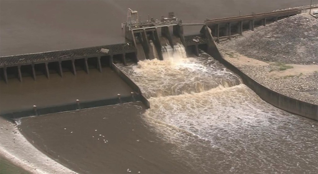
Both Lake Conroe and Lake Houston are water-supply dams. But Lake Houston, built in the early 1950s, has a 3160-foot, fixed-height spillway with four small gates capable of releasing only 10,000 cubic feet per second (CFS) combined. Clearly, engineers prioritized consistent water level over flood mitigation when designing this dam. The small gates make it difficult and time consuming to release water before it reaches the level of the spillway.
According to the Houston Public Works Drinking Water Operations Group, Lake Houston supplies water to 2.2 million people.
Lake Conroe, built in 1973, has five large gates capable of releasing 150,000 CFS. It was designed as an alternate water supply for the City of Houston. The City financed its construction and owns two thirds of the water in the lake.
Lake Conroe has nothing comparable to the fixed-height spillway on Lake Houston.
3160-foot concrete and steel spillway on Lake Houston
Compared to spillway above, gates on Lake Houston can release only a small amount. But the spillway can release more than Lake Conroe.See below.It just can’t release that much before a storm.Lake Houston Dam during Harvey. The wall of water flowing out of the lake was 11 feet higher than the spillway.
During the peak of Harvey, an estimated 425,000 CFS went over the Lake Houston Spillway – 5 times the average flow of Niagara Falls.
In contrast, Lake Conroe released about 80,000 CFS from its gates during Harvey. So why the push to add more gates to Lake Houston?
Gates Key to Hybrid Strategy
Simple. Bigger gates are key to both water conservation and Active Storm Management. Right now, Lake Houston’s gates are so small that lowering the lake significantly can take days. During that time, storms can veer away.
That long lead time creates uncertainty that jeopardizes what Houston Public Works and the Coastal Water Authority see as their primary mission – providing water for 2.2 million people.
We just can’t create extra storage capacity in Lake Houston fast enough with the existing gates.
Why is Design Taking So Long?
But with more, larger gates, Lake Houston could release enough water in hours to create extra storage capacity. And operators would have confidence that water would not be wasted. So why are the gates taking so long?
Design of more gates for Lake Houston has just now started. Using Harvey as a starting point, we are now almost at twice the amount of time that it took to win World War II.
It’s hard to believe that if everyone agreed with the need for more flood gates, it would have taken this long to start design.
In that regard, I have heard of pushback from both Houston Public Works and Coastal Water Authority. The pushback had to do with the mission of the organizations: to supply water. They just didn’t want to risk wasting it in case we encountered drought.
But our two backup water sources (Lake Conroe and Lake Livingston) combined have 15 times the volume of Lake Houston. So the City probably won’t run short anytime soon.
Flood Mitigation Not In CWA Mission
The Coastal Water Authority, which is the City’s contract operator for Lake Houston, does not even mention “flooding” on its website. That’s right. CWA doesn’t mention the word in its mission statement, guiding principles, strategies, or tactics. They do, however, mention “pumps” 15 times on their Strategic-Plan page. That should give you some idea of their priorities: water supply.
Hopefully, Mayor John Whitmire’s recent appointment of former State Representative Dan Huberty to the Coastal Water Authority Board will help the CWA see Lake Houston from more than one perspective. Huberty has advocated for the gates since Harvey.
Posted by Bob Rehak on 9/29/24
2588 Days since Hurricane Harvey
The thoughts expressed in this post represent opinions on matters of public concern and safety. They are protected by the First Amendment of the US Constitution and the Anti-SLAPP Statute of the Great State of Texas.
https://i0.wp.com/reduceflooding.com/wp-content/uploads/2019/02/LakeHoustonDamDuringHarvey.jpg?fit=1500%2C968&ssl=19681500adminadmin2024-09-29 20:13:322024-09-29 20:23:55Flood-Control, Water-Supply Dam Differences Help Explain Delay on Lake Houston Gates
9/28/24 – Forecasters predicted a very active 2024 hurricane season. After a slow start, the map is really lighting up. Currently, we have three named storms in the Atlantic Basin:
Remnants of Hurricane Helene, which is now a post-tropical depression centered over Tennessee
Hurricane Isaac, which formed in the middle of the Atlantic without much notice while Helene was barreling toward Florida earlier this week
Tropical Storm Joyce, also in the mid-Atlantic
Still Brewing
None of those named storms is a threat to Houston. However, the map shows two other areas of concern. See below.
Red Area
That elongated red area in the tropical Atlantic a couple hundred miles west of the Cabo Verde Islands continues to produce disorganized showers and thunderstorms.
According to the National Hurricane Center (NHC), environmental conditions appear conducive for gradual development of this system. A tropical depression will likely form during the early or middle part of next week. The system should move toward the west and then northwest across the eastern and central tropical Atlantic.
As of today, NHC lists formation chances for that red area as low (30%) in the next two days, but high (70%) in the next seven days.
Orange Area
Of greater concern for Texans, however, though is that orange area stretching from the northwestern Caribbean to the Gulf of Mexico. An area of low pressure should form there within a couple of days. NHC says environmental conditions are conducive for gradual development thereafter. They also say that a tropical depression could form around the middle part of next week.
This system should move northwestward into the Gulf during the latter portion of next week. NHC warns that interests in and along the Gulf Coast should monitor its progress.
As of today, formation chance through 48 hours is zero. But it’s 50% within 7 days.
Will the Gulf Go 4 for 4?
Lest anyone forget, this area has already spawned two major hurricanes and a hurricane in the last three months – Beryl, Francine and Helene.
Beryl ramped up to a Category 5 before hitting Houston in July.
Francine slammed Louisiana as a Cat 2 in September
Helene made landfall in Florida as a Cat 4 just two days ago.
Sea surface temps in that area are still 1.8 to 5.4 Fahrenheit above normal for this time of year (1-3º C).
So, don’t let your guard down.
Posted by Bob Rehak on 9/28/24
2587 Days since Hurricane Harvey
https://i0.wp.com/reduceflooding.com/wp-content/uploads/2024/09/two_atl_7d0-3.png?fit=900%2C665&ssl=1665900adminadmin2024-09-28 13:52:242024-09-28 14:06:39Three Named Storms in Atlantic Basin With Two More Brewing
9/27/24 – Hurricane Helene roared ashore last night and by noon today had triggered flooding in at least eight states, according to the National Weather Service.
Helene Floods Eight States
The states include: Florida, Alabama, Georgia, South Carolina, North Carolina, Tennessee, Virginia and Kentucky. See orange, red and purple areas below.
From NWS Water Prediction Center. Gage data from noon 9/26/24 to noon 9/27/24. Purple = Major Flooding, Red = Moderate, Brown = Minor. Yellow = Action.
Many of those same areas could still see additional rainfall. Through 7 AM CDT, NOAA’s Weather Prediction Center gives 15 states a chance for additional excessive rainfall. See below.
Power Outages and Deaths
Meanwhile, more than 3 million people in affected areas remain without power, according to PowerOutages.US.
The Hill reports that at least 35 people died as a result of the Category 4 storm.
At this hour, NBC puts the death toll at 42 and says more than 4 million people are without power.
USA Today reported within the hour that 4.5 million people have no electricity.
The death toll will likely increase in coming days as rescuers race to free more people trapped in flooded areas.
It could take weeks to restore all the power given the breadth of the devastation. An Associated Press report said that in Georgia, “…an electrical utility group warned of ‘catastrophic’ damage to the state’s utility infrastructure, with more than 100 high voltage transmission lines damaged.”
AP also reported that in South Carolina, “more than 40% of homes and businesses were without power.” They said crews needed to cut their way through debris just to determine what was still standing in some places.
Helene Now a Tropical Depression
At 4 PM, the National Hurricane Center has downgraded Helene to a tropical depression with sustained winds of 35 MPH and forward motion of 17 MPH.
Summary of Weather Stats
For a list of reported rainfall totals to date and peak wind gusts associated with Helene, see this list from the National Centers for Environmental Prediction as of 11 AM EDT 9/27/24. Busick, North Carolina recorded the highest rainfall total to date: 29.58 inches.
All in all, the forecasters predicted Helene’s impacts pretty accurately.
Helene is the latest reminder of why we need to continue fighting for flood mitigation. It could have happened here.
Posted by Bob Rehak on 9/27/24
2586 Days since Hurricane Harvey
https://i0.wp.com/reduceflooding.com/wp-content/uploads/2024/09/20240927-Helene-Flooding.jpg?fit=1100%2C614&ssl=16141100adminadmin2024-09-27 17:01:582024-09-27 17:27:06Helene Triggers Flooding in 8 States, Millions Without Power
9/26/24 5:20 PM CDT Update – Helene has become a Category 4 storm with 130 MPHsustained winds.
According to the National Hurricane Center (NHC), Helene is rapidly becoming one of the “largest hurricanes in decades.” Comparing Helene to previous hurricanes in the Gulf of Mexico, they say, “Helene is at the upper bound in terms of size.”
Widespread Impacts, “Immense Human Suffering”
Helene’s hurricane-force winds extend outward up to 60 miles from the center. And tropical-storm-force winds extend outward up to 345 miles.
“As a result , storm surge, wind, and rainfall impacts will extend far away from the center and well outside the forecast cone, particularly on the east side,” they say.
“In addition, the fast forward speed when Helene moves inland will result in a far inland penetration of strong winds. That includes strong gusts over higher terrain of the southern Appalachians.”
Jeff Lindner, Harris County’s meteorologist, characterized Helene as “extremely dangerous.” He said, “Widespread and significant impacts will produce immense human suffering by modern standards.”
Large parts of the SE US will have a greater than 50% chance of tropical-storm-force or higher winds from Helene.
Already High End of Category 2 at 10 AM
As of 10AM, maximum sustained winds had increased to near 105 MPH with higher gusts. That puts Helene just five miles per hour from becoming a major category three hurricane.
Helene was moving toward the Big Bend area of the Florida Panhandle at 14 MPH and will make landfall this evening. After landfall, Helene should turn northwestward and slow down over the Tennessee Valley on Friday and Saturday.
The minimum central pressure has plummeted to 947 mb.
Additionally, water level rise along the west coast of Florida has begun and will quickly worsen through the day. Catastrophic storm surge will reach up to 15-20 feet above normally dry ground.
Over portions of the Southeastern U.S. into the Southern Appalachians, Helene is expected to produce total rain accumulations of 6 to 12 inches, with isolated totals around 20 inches.
This rainfall will likely result in catastrophic and potentially life-threatening flash and urban flooding, along with significant river flooding. Numerous significant landslides are expected in steep terrain across the southern Appalachians.
Key Messages
A catastrophic and deadly storm surge is likely along portions of the Florida Big Bend coast, where inundation could reach as high as 20 feet above ground level, along with destructive waves. There is also a danger of life-threatening storm surge along the remainder of the west coast of the Florida Peninsula.
Potentially catastrophic hurricane-force winds are expected within the eyewall of Helene when it makes landfall in the Florida Big Bend region this evening. Damaging and life-threatening hurricane-force winds, especially in gusts, will penetrate well inland. Strong wind gusts are also likely farther north across portions of northern Georgia and the Carolinas, particularly over the higher terrain of the southern Appalachians.
Catastrophic and life-threatening flash and urban flooding, including numerous significant landslides, is expected across portions of the southern Appalachians through Friday. Widespread significant river flooding and isolated major river flooding are likely.
Helene in Historical Perspective
All indications at this point suggest Helene will have a huge impact on the southeastern US.
Helene at 10 AM Central Daylight TimeWider shot taken at 5:30 PM CDT slightly before landfall.
“This is likely to be the worst hurricane event for this area in over a generation. Conditions near the coast will not be survivable.”
Jeff Lindner, Harris County Meteorologist
Lindner continued, “Since 1851 there are no records of storms of this magnitude in Apalachee Bay. All coastal structures/infrastructure lower than 15 ft will be completely destroyed. Older slab built structures in this area will suffer catastrophic damage and likely be washed away. Water levels will almost certainly rise to the second floors of elevated structures and some of these will face total collapse. All available efforts should be utilized to evacuate these areas.”
Posted by Bob Rehak on 9/26/24 at 11 AMbased on information from NHC and Harris County
2585 Days since Hurricane Harvey
https://i0.wp.com/reduceflooding.com/wp-content/uploads/2024/09/1000x1000.jpg?fit=1000%2C1000&ssl=110001000adminadmin2024-09-26 11:41:132024-09-26 18:10:54Helene Will Be One of Largest Hurricanes in Decades
9/25/24 3PM CDT – Today, Helene intensified into a hurricane and it should become a major hurricane before making landfall tomorrow in the Big Bend area of the Florida Panhandle. Some forecasters are predicting a Category 3 storm, others a Cat 4.
Helene will accelerate to the north today and Thursday crossing the entire Gulf of Mexico in a 24-30 hour period and reach the Florida Gulf coast late Thursday, according to the National Hurricane Center (NHC).
Warm Waters Will Fuel Rapid Intensification
Harris County Meteorologist Jeff Lindner says, “Helene will be passing over extremely warm waters that extend 100-200 feet deep. That supports great levels of intensity in developing hurricanes. Nearly all the hurricane intensity models bring Helene to Category 4 over the eastern Gulf of Mexico. The official forecast is for a 120mph category 3, but this may need to be adjusted upward given current trends and guidance.”
Regardless, all forecasters comment on the size of Helene. At 1PM, tropical storm force winds extended outward 275 miles from the center, according to NHC.
Hurricane Helene as of 1PM CDT on 9/25/24
As a result, they predict Helene’s impacts will extend well inland. Tropical storm force winds will likely reach Atlanta and even the southern Appalachian Mountains.
Life-Threatening Storm Surge
But the most certain threats to life and property have to do with storm surge. Today forecasters say it could reach up to 20 feet above land; yesterday it was 15.
Jeff Lindner, Harris County’s meteorologist says, “Structures lower than 10 ft will be completely destroyed along the entire Florida nature coast. This will potentially be a record storm surge event for the eastern side of the Florida Big Bend, likely surpassing previous records from the March 1993 ‘superstorm’ surge event.”
Torrential Rain and Flash-Flood Threats
Farther inland, the threat will be torrential rains. Atlanta, which usually doesn’t experience tropical threats, could receive 8-12 inches with higher isolated totals. Areas in the mountains north of Atlanta could receive 16-20 inches.
A potentially catastrophic inland flash flood event is becoming increasingly likely as Helene interacts with a stalled frontal boundary and the higher terrain of the southern Appalachian mountains from northern Georgia into western North Carolina and eastern Tennessee.
In the rainfall map above, note the red and brown colored areas along the North Carolina/Tennessee border. That is a mountainous region.
The excessive rainfall there is orographic in origin. Orographic means precipitation caused by hills or mountain ranges deflecting moisture-laden air masses upward, causing them to cool and precipitate their moisture.
All that precipitation will likely trigger flash flooding.
Widespread travel disruption is likely over the southeast from Thursday into Saturday. Recovery of essential services will be slow due to the widespread, significant impacts.
Key Messages
The NHC warns:
Due to the large size of Helene, there is a danger of life-threatening storm surge along the entire west coast of the Florida Peninsula and Florida Big Bend. Residents should follow the evacuation advice of local officials.
Devastating hurricane-force winds will reach from northern Florida into southern Georgia. Because of Helene’s expected fast forward speed, damaging and life-threatening wind gusts are expected to penetrate well inland to the southern Appalachians.
Helene will bring heavy rain and potentially life-threatening flash and urban flooding. Impacts will stretch across portions of northwestern and northern Florida, the Southeast, southern Appalachians, and the Upper Tennessee Valley Wednesday through Friday.
Widespread minor to moderate river flooding is likely, and isolated major river flooding is possible.
Types of Damage Associated with Category 4 Hurricanes
The National Weather Service lists types of damage typically associated with a Category 4 Hurricane. “Winds 130-156 mph. Catastrophic damage will occur: Well-built framed homes can sustain severe damage with loss of most of the roof structure and/or some exterior walls. Most trees will be snapped or uprooted and power poles downed. Fallen trees and power poles will isolate residential areas. Power outages will last weeks to possibly months. Most of the area will be uninhabitable for weeks or months.”
https://i0.wp.com/reduceflooding.com/wp-content/uploads/2024/09/Hurricane-Helene.jpg?fit=1100%2C740&ssl=17401100adminadmin2024-09-25 15:00:272024-09-25 21:16:38Helene Now a Hurricane 550 Miles Across, Impacts Will Spread Far Inland
9/24/24 at 1 PM – This morning, Potential Tropical Cyclone 9 became Tropical Storm Helene when satellite images and Hurricane Hunter aircraft data noted a well-defined center of circulation and sustained winds of 45 MPH with higher gusts.
Helene is moving toward the northwest near 12 mph and will likely continue to do so through early Wednesday. The National Hurricane Center expects northward to north-northeastward motion at a faster forward speed on Wednesday and Thursday.
On the forecast track, the center of Helene will move across the far northwestern Caribbean Sea through tonight, and then move across the eastern Gulf of Mexico Wednesday and Thursday, potentially reaching the Gulf coast of Florida late Thursday.
Additional strengthening is forecast. Helene should become a hurricane on Wednesday and could become a major hurricane on Thursday.
A major factor in the forecast of hazards is the size of the storm. Currently, tropical-storm-force winds extend outward up to 140 miles to the east of the center. Helene’s forecast radii are at the 90th percentile of hurricane size at similar latitudes. If accurate, that means only 10% of hurricanes will exceed its size.
Due to the forecast large size of this system, storm surge, wind, and rainfall impacts will extend well away from the center, particularly on the east side.
Hazards Affecting Land
Rainfall
Heads up if you have friends, family or travel plans in the southeast this week. Helene should produce total rain accumulations of 4 to 8 inches with isolated totals around 12 inches. This rainfall will likely result in areas of considerable flash and urban flooding, with minor to moderate river flooding likely, and isolated major river flooding possible.
The combination of a dangerous storm surge and high tide will cause normally dry areas near the coast to flood. The water could reach 10-15 feet above ground between Ochlockonee River, FL and Chassahowitzka. For other areas see the map below.
Hurricane conditions are possible within the U.S. watch areas Wednesday night and early Thursday.
Tropical storm conditions should hit the Lower Florida Keys beginning Wednesday, and are possible in the watch area in the Middle Florida Keys beginning late Wednesday.
Helene should make landfall in the Panhandle Thursday morning and reach Atlanta by Thursday evening or Friday morning.
Compared to yesterday’s forecast, the chance of damaging winds now extends much farther north, well into Georgia.
The fast forward speed of the storm when it crosses the coast will likely result in inland penetration of strong winds over parts of the southeastern United States well after landfall.
Surf
Swells will spread northward toward the west coast of Florida and the northeastern Gulf Coast on Wednesday and Thursday. These swells are likely to cause life-threatening surf and rip current conditions.
Intensification
Several factors suggest rapid intensification of Helene:
Shear over the system will decrease. Model guidance continues to show relatively low to moderate shear for the next 48 hours or so.
Oceanic heat content values are very high.
The system will move through an environment of upper-level divergence.
Therefore, NHC anticipates significant strengthening. NHC’s intensity forecast shows the system reaching a peak intensity around 100 kt (116 MPH) in 48 hours while over the eastern Gulf of Mexico.
Given the system’s large size, it might only weaken slowly even if it encounters sheer near the Panhandle. As a result, there is still a risk that the system could reach the coast as a major hurricane.
Key Messages
1. Helene will be near hurricane strength early Wednesday when it shoots the gap between the Yucatan and Cuba.
2. Helene should rapidly intensify over the eastern Gulf and become a major Category 3 hurricane as it approaches the coast on Thursday. The risk of life-threatening storm surge and damaging hurricane-force winds continues to increase along the coast of the Florida Panhandle and Florida’s west coast. Hurricane and Storm Surge Watches are in effect for much of that area. Residents should follow advice given by local officials.
3. Helene will bring heavy rain which will likely result in locally considerable flash and urban flooding across portions of Florida, with isolated flash and urban flooding possible across the Southeast, Southern Appalachians, and the Tennessee Valley Wednesday through Friday. Minor to isolated moderate river flooding will also be possible.
Here’s what Helene looked like this morning from space.
Helene as of 10AM 9/24/24 CDT circled in red.
Posted by Bob Rehak at 1 PM on 9/24/24
2584 Days since Harvey
https://i0.wp.com/reduceflooding.com/wp-content/uploads/2024/09/TS-Helene.jpg?fit=1100%2C723&ssl=17231100adminadmin2024-09-24 13:03:342024-09-24 13:15:22TS Helene Pushing North, Intensifying, Expanding
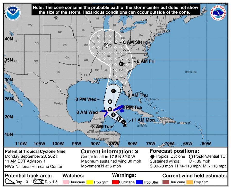
9/23/24 at 12 PM – The National Hurricane Center has designated a disturbance in the northwestern Caribbean as Potential Tropical Cyclone 9. Currently, NHC gives the storm a 90% chance of development in the next two days.
According to Harris County Meteorologist Jeff Lindner, models indicate it will likely escalate into a Category 4 hurricane as it heads north over the warm waters of the Gulf.
However, it will likely make landfall along the Florida Panhandle. Current forecasts indicate no threat to Texas. Overnight, the projected track of the storm shifted farther east.
Projections as of Noon Monday
I’m posting this because Houston residents may have friends, relatives or travel plans in affected areas. See below.
Center of storm has equal change of tracking anywhere within cone. Cone does not indicate width of storm.
Tropical storm force winds associated with Potential Tropical Cyclone 9 should arrive in the big bend area of the Florida panhandle sometime between Wednesday night and Thursday morning.
NHC predicts a 50:50 chance for tropical storm force winds extending north into Georgia.
The National Weather Service has this to say for people in the Panhandle and southern Georgia, “There is a potential for significant storm surge; heavy rainfall and flooding; and strong winds across the north and eastern Gulf Coast.”
“Impacts could begin as early as Wednesday night and last into Friday,” says NWS. “More detailed and specific impacts will be highly dependent on future track/intensity and we’ll be including those in future updates in the next day or two.”
Winds have a 95 percent chance of a 75 MPH increase during the next 72 hours.
National Hurricane Center
Frequency of Major Hurricanes
When/if the Potential Tropical Cyclone 9 reaches 39 MPH, NHC will dub it Helene.
We’ve already had one major hurricane in the Gulf this year – Beryl. The second major hurricane usually develops in the Atlantic Basin by September 19. So, even though this season has fewer than normal named storms, it will have an average number of major hurricanes for this part of the season if Helene becomes a Category 3 or higher.
At present, NHC says the area of concern in the northwestern Caribbean between Honduras and Cuba continues to produce disorganized showers and thunderstorms. Some mid-level rotation is evident in visible satellite images.
A gradual turn toward the northwest is expected during the next day or so. Models agree that the center of the system should reach the northeast Gulf on Thursday.
Since the disturbance currently lacks a well-defined center, future track adjustments may be required. Given the large size of the tropical-storm-force wind field and fast forward speed that is forecast, storm surge, wind, and rainfall impacts will likely extend well away from the center, particularly to the east of the system.
While the system is currently broad and not well organized, the models suggest a more well-defined center should develop during the next day or so.
Once the system becomes better organized and develops an inner core, the environmental and oceanic conditions appear favorable for significant strengthening. The sea surface temperature anomaly chart below shows that temperatures in the Caribbean and Gulf are up to 8 degrees Fahrenheit warmer than average for this time of year.
An Air Force Reserve reconnaissance aircraft will investigate the system this afternoon.
Tropical Storm Warnings and Hurricane Watches have already been issued for portions of western Cuba and the Yucatan Peninsula of Mexico.
Key Messages
The disturbance will strengthen and be near hurricane strength when it reaches the far northwestern Caribbean Sea Tuesday night.
The system will intensify and could become a major hurricane when it reaches the northeastern Gulf Coast on Thursday.
There is an increasing risk of life-threatening storm surge and damaging hurricane-force winds along portions of the northern and northeastern Gulf Coast, including the Florida Panhandle and portions of the Florida west coast. But it is too soon to specify the exact location and magnitude of impacts.
Potential Tropical Cyclone Nine will bring heavy rain to portions of the western Caribbean. That may lead to flooding and possible mudslides in western Cuba.
Potential Tropical Cyclone Nine will likely produce total rain accumulations of 4 to 8 inches over western Cuba and the Cayman Islands with isolated totals around 12 inches.
Heavy rainfall will spread into the Southeast U.S. starting on Wednesday and continuing through Friday, bringing a risk of flash and river flooding.
For the latest rainfall forecasts associated with Potential Tropical Cyclone Nine, see the National Weather Service Storm Total Rainfall Graphics.
Posted by Bob Rehak on 9/23/24
2582 Days since Hurricane Harvey
https://i0.wp.com/reduceflooding.com/wp-content/uploads/2024/09/153941_5day_cone_no_line_and_wind.png?fit=897%2C736&ssl=1736897adminadmin2024-09-23 12:40:592024-09-23 16:50:08NHC Issues Advisory on Potential Tropical Cyclone 9
9/22/2024 at 6PM – The National Hurricane Center (NHC) issued a 2PM update today that warns of an 80% chance of a potential new tropical system forming in the seven days. They give the new tropical system a 40% chance in the next two days. The system is now centered in the northwestern Caribbean between Honduras and Cuba.
However, NHC predicts the storm will track somewhere between New Orleans and the Florida Panhandle. While it is no immediate threat to Texas, residents should keep an eye on developments in the next few days, they say.
NHC Graphics
Two-day outlook gives system a 40% chance of development.Seven-day outlook gives the system an 80% chance.
Favorable Environmental Conditions
NHC predicts the track will bend east after crossing between the Yucatan and the western tip of Cuba.
“Disorganized showers and thunderstorms located over the northwestern Caribbean Sea and portions of Central America are associated with a broad area of low pressure,” they say. “Environmental conditions appear favorable for development of this system, and a tropical depression or tropical storm is likely to form during the next few days…”
Regardless of development, this disturbance will produce heavy rains over portions of Central America during the next several days. Interests in the northwestern Caribbean, Yucatan Peninsula, and western Cuba should closely monitor the progress of this feature.
Later this week, the system should move generally northward across the Gulf of Mexico, and “interests along the northern and northeastern Gulf Coast should also monitor the progress of this system.”
Potential system in center of frame could be pulled north and east by an exiting low-pressure system that now stretches from West Texas to New Englandnear top of frame.
Local Impacts Seen as Limited As of Now
Jeff Lindner, Harris County’s meteorologist, said, “The system should lift northward over the Gulf of Mexico by mid to late week. A large upper level low over the southern plains will help draw the tropical system north of northeast toward the US Gulf coast.”
Lindner added that most models are in agreement at this point which makes confidence fairly high. However, he also said, “There may be some small differences in the ultimate track toward the US Gulf coast.”
He concluded, “Guidance also suggests this will be a large tropical system which is capable of moving huge amounts of water in the Gulf.”
“With the current higher than normal fall lunar tides in place, there is some potential for elevated tides along the Texas coast late this week, even for a tropical system passing well to our east.”
If this system turns into a named storm, it will become Helene.
Everyone predicted a severe hurricane season this year, but so far, it has not materialized. On average, we have our tenth named storm by now. See below.
All last week, forecasters warned that this storm had a chance of development. And on most days, the chances increased. Keep your eye on this one!
Posted by Bob Rehak on 9/22/24
2581 Days since Hurricane Harvey
https://i0.wp.com/reduceflooding.com/wp-content/uploads/2024/09/two_atl_7d0-2.png?fit=900%2C665&ssl=1665900adminadmin2024-09-22 18:30:362024-09-22 18:30:37Potential New Tropical System Headed Toward Central Gulf
9/21/2024 – Is Beryl debris cleared from the stream or channel nearest you yet? Here’s how to report fallen trees when you find them blocking waterways. Hurry. Once the equipment is gone, it will be hard to get it back.
Harris County Flood Control District and FEMA contractors have been hard at work for the last two months removing those blockages. But they have 2500 miles of channels to clear. Some of those miles, like those in Kingwood, are difficult to access and they’re massively clogged with debris.
Ensuring debris is removed involves reporting the precise location of blockages which don’t always have street addresses. If your phone doesn’t embed GPS coordinates in images, identify the location on the channel map in Harris County’s Flood Education Mapping Tool.
In many cases, clearing blockages may also involve negotiating rights of access with contractors across homeowner or trail association property. So make sure you inform your associations, too.
How Debris Creates Hidden Flood Threats
On July 8, Beryl bulldozed its way through Houston. The damage was especially bad in the Lake Houston Area. Trees fell on roofs and power lines everywhere. Many homes still await repair, though power has been restored.
But hidden out of sight, are hundreds, if not thousands of trees that fell into our streams and channels, deep in the woods where most people don’t see them. If left in place, these trees can catch others swept downstream in future floods. And the resulting log dams, can back water up into homes, causing even more damage.
And Beryl left a lot of debris.
Removing 350 Tons from One Channel in One Day
Optimal, a FEMA contractor, said they removed 350 tons of debris from one channel in Kings Forest in one day. The work involved several vehicles. That’s 700,000 pounds.
See the pictures below supplied by Chris Bloch, a Bear Branch Trail Association Director. He took them on on 9/18/24 in Kings Forest and Kingwood Lakes.
The yellow tracked vehicle in the creek cuts logs (right) and wrestles them into another tracked vehicle which hauls them out of the woods.
Here’s what they are up against.
It’s was a messy job. But they removed the threats.
The 12-Ton tracked dump truck hauled the logs and brush to the Kings Forest Pool parking lot.They piled it up for other trucks to take away. It all operated like an assembly line. Or should I say disassembly line?
Some blockages may require bigger equipment which is in shorter supply according to Bloch. In those cases, contractors may have to return later. The main thing is to report all the damage you find to HCFCD now. They still have quite a few Kingwood channel sections to clear. But hurry. Hurricane season is far from over.
Posted by Bob Rehak on 9/21/24
2580 Days since Hurricane Harvey
https://i0.wp.com/reduceflooding.com/wp-content/uploads/2024/09/20240918-Bear-Branch-from-KW-Drive.jpg?fit=1100%2C831&ssl=18311100adminadmin2024-09-21 18:58:502024-09-21 19:15:35Is Beryl Debris Cleared from Your Stream or Channel Yet?