Latest NHC Forecasts Show Francine Aiming for Louisiana
9/10/24 – Update: At 7 PM, the National Hurricane Center announced that Francine became a hurricane with sustained winds of 75 MPH and higher gusts. By 10:20, hurricane hunter aircraft found sustained winds of 85 MPH with central pressure of 979 mb. Hurricane-force winds extend outward up to 35 miles from the center and tropical-storm-force winds extend outward up to 115 miles. Other details have not changed much since 4PM. See below.
The National Hurricane Center’s (NHC) 4 PM update shows Tropical Storm Francine taking aim for Louisiana. Its impacts will likely diminish in the Houston area. However, tropical storm warnings and watches now extend past Louisiana into Mississippi and Alabama, as the forecast track shifts farther east.

Francine Winds and Forward Speed
At 4 PM, Francine still packed 65 MPH winds with higher gusts. But NHC expects it to reach hurricane strength tonight. By convention, storms become hurricanes at 74 MPH.
A Hurricane Warning is in effect from Sabine Pass eastward to Grand Isle. NHC forecasts that Francine could reach 80 knots/92 MPH at landfall in central Louisiana. If accurate, that would put it just shy of a Category 2 hurricane.
Hurricane hunter aircraft found that pressure in the central core had dropped to 987 mb. The storm has become better organized with increased banding.
Tropical-storm-force winds extend outward up to 140 miles (220 km) from the center. To put that in perspective, Beaumont is 175 miles from Baton Rouge, which is in central Louisiana.
Two NHC graphics depict the probability of damaging winds reaching the Houston area. The first shows the north Houston area has a 5-10 percent chance of experiencing tropical-storm-force winds.

The second shows we have a zero percent chance of experiencing hurricane force winds.

Track
According to NHC, Francine has made a turn toward the northeast and increased its forward motion to 10+ MPH. It should reach the central Louisiana coast sometime Wednesday afternoon or evening. A continued northeastward motion and a faster forward speed are expected tonight and Wednesday.

Surge
We still can expect storm surge in coast areas all the way from Freeport to the Florida Panhandle.

With that comes the associated risk of rip currents.
Rainfall
Francine is expected to bring storm total rainfall of 4 to 8 inches, with local amounts to 12 inches across eastern Louisiana, Mississippi, far southern Alabama and the western Florida Panhandle through Friday morning. This rainfall could lead
to considerable flash and urban flooding in those locations.
However, Jeff Linder, Harris County’s meteorologist less than an inch of rain in the Lake Houston Area.

We barely have a chance for flash flooding. And significant rainfall accumulations will be concentrated east of Texas.

While the Lake Houston Area may be spared the storm’s worst effects, the Mississippi Valley won’t. NHC predicts significant flooding for that area.
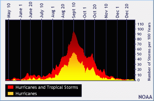
Today Is Statistical Peak of Hurricane Season
Today is the statistical peak of hurricane season and Francine makes our sixth named storm in the Atlantic Basin.
To put that in perspective, during the last 30 years, we usually have had 10 named storms by September 4 and 11 by September 14. So despite early dire warnings, this season has been less severe than normal.
The 2017 hurricane season should remind us all that it only takes one storm to change lives forever. Pray for our neighbors to the east. And remain vigilant.
Posted by Bob Rehak on 9/10/24
2569 Days since Hurricane Harvey and 69 since Beryl