Widespread heavy rainfall along and north of I-10 over the last 24 hours has resulted in rainfall amounts of 2-3 inches over much of that area. Pockets have received 4-5 inches. Those include northern Waller and western Montgomery Counties. Portions of Walker County received 4-6 inches.
Ongoing flooding through much of today closed several roads in low lying areas of northern Waller and Walker Counties. Run-off continues to progress down creeks and into mainstem rivers. Rises will continue along upper Spring Creek into tonight and Saturday. However, at the moment forecasters expect no significant flooding. See attached graphics for 24-hr rainfall totals and current channel status.
First Round Kicks Off Overnight
NWS satellite imagery shows moisture streaming up out of Mexico as of 7PM Friday. The area along the middle Texas coast from the coastal bend up to to about Wharton looks favorable for the formation of another round of heavy to excessive rainfall late tonight and early tomorrow. Models indicate this activity will occur mostly west of I-45 and south of I-10 into Saturday morning before it begins to weaken. Exactly how far northeast rain and heavy rain may spread is still in question. But according to Jeff Lindner, Harris County’s meteorologist, “The latest thinking indicates it will remain southwest of the areas hard hit today.”
Second Round of Storms Saturday Night into Sunday
Lindner predicts a weakening of the storm Saturday afternoon. But he warns to expect numerous showers and thunderstorms Saturday evening. He says they will invade the region from the southwest to northeast. Moisture levels will support heavy to excessive rainfall rates within any organized thunderstorms.
Rainfall Amounts
Expect additional rainfall amounts of 1-3 inches over the weekend with isolated totals reaching 4-6 inches…especially around the coastal bend and Matagorda Bay tonight into early Saturday.
Area Soils Now Saturated
I received 3.07 inches in my rain gage today and have standing water in my yard. Soils have become nearly saturated in areas that saw the greatest rainfall today, while areas around Galveston Bay have experienced little rainfall thus far. Heavy run-off in many areas north of I-10 will cause rises in several channels. Keep an eye on the East Fork of the San Jacinto River at FM 1485 into the weekend. The forecast there currently exceeds flood stage.
A good amount of water is routing into the West Fork of the San Jacinto also. But current forecasts keep the river from Conroe to Humble below flood stage. The SJRA is releasing water from Lake Conroe at almost 6000 cubic feet per second. Despite that, the lake level has risen almost a foot and a half today above its normal pool level.
As of 7PM 4/30/2021.
The areas north of the lake received some of the highest rainfall totals this morning. This lake is now 3.5 feet above where it was when the SJRA stopped the seasonal lowering last week. Had they now lowered the lake a foot, it would be even higher now. We can all learn from this experience.
Minor flooding will also be possible this evening along upper Spring Creek west of Hegar Rd with rural low lands near the creek inundated.
Additional rainfall over the weekend may change some of the current forecasts.
Posted by Bob Rehak on 4/30/21 at 8PM based on info from the NWS and Harris County Meteorologist Jeff Lindner
1340 Days since Hurricane Harvey
https://i0.wp.com/reduceflooding.com/wp-content/uploads/2021/04/Rainfall-4.30.21.jpg?fit=1200%2C669&ssl=16691200adminadmin2021-04-30 19:45:422021-04-30 19:50:27Two More Rounds of Heavy Rain Yet to Come; Flash Flood Watch Extended Through Sunday
UPDATED AS OF 10PM THURSDAY – Jeff Lindner, Harris County’s meteorologist, warns that heavy rainfall potential will spread across the region tonight through the weekend.
Rainfall accumulations expected by NWS in next 5 days. Updated at 5:51PM Houston time on 4/29/2021.
National Weather Service has issued a Flash Flood Watch for much of Southeast Texas tonight through Sunday morning. However, the risk is slight.
Most of the Houston region has a marginal or slight risk of flash flooding – less than 20%.
Lakes Houston, Conroe Being Lowered
Houston Public Works is currently lowering Lake Houston by 12 inches, from 42.5 feet to 41.5 feet in response to the newly updated forecast – 3 inches of rain in our watershed within 24 hours. Property owners along the lake should secure property along the shoreline. To monitor current water levels at Lake Houston, visit www.coastalwaterauthority.org.
The SJRA had stopped its seasonal release from Lake Conroe. Rains from last weekend pushed the lake back up past its normal full pool level of 201 feet. As of 7pm Thursday, the SJRA had not resumed releasing any water, but by 10pm it had.
Lake Conroe level as of 7pm on 4/29/2021
As of 10pm, SJRA had started releasing 530 cubic feet per second.
Inflow from Gulf Will Collide With Stalled Front over SE TX
“A slow-moving, upper-level, low-pressure system over the southwest will combine with a surface front that will move into southeast Texas later today,” says Lindner. He expects the fronts to stall over our area. He says they will produce numerous rounds of showers and thunderstorms from late this afternoon into Sunday.
Onshore flow has increased moisture over the region with dewpoints running in the low to mid 70’s. The surface front extends from northeast Texas to near Laredo. It will move slowly into southeast Texas late this afternoon and then likely stall between downtown and the coast by Friday morning. Other disturbances, says Lindner, will ride along this frontal boundary toward the northeast helping to produce several rounds of showers and thunderstorms.
With the upper level winds becoming increasing parallel to the stalling surface front and moisture levels remaining high into the weekend, the threat for heavy rainfall will be increasing. Storm motions are expected to slow on Friday, but coverage remains scattered, so some areas could see some decent rainfall while other get little.
Threat Remains Through Sunday
Expect widespread storms to develop on Saturday morning as the threat for cell training increases.
The slow moving upper level low will then move directly across the area on Saturday night into Sunday with additional rounds of thunderstorms…some of these storms could be severe along with more heavy rainfall.
Widespread rainfall amounts of 1-3 inches will be possible with isolated totals of 4-5 inches. With all the moisture in place, high rainfall rates could cause street flooding.
Jeff Lindner, Harris County Meteorologist
Lindner warns potentially higher totals are possible given the overall slow moving nature of the weather pattern.
Increasing Runoff as Grounds Saturate, Marginal Risk of Flash Flooding
The dry ground conditions now in place means soil will absorb much of this rainfall. Regardless, Lindner predicts rises on area creeks and bayous. He says that grounds will begin to saturate over the weekend yielding greater run-off as the storm wears on.
The National Weather Service has all of southeast Texas in a marginal risk for flash flooding starting Friday and into Saturday.
Posted by Bob Rehak on 4/29/2021 based on information by Harris County Meteorologist Jeff Lindner and the National Weather Service
1339 Days since Hurricane Harvey
https://i0.wp.com/reduceflooding.com/wp-content/uploads/2021/04/image001.gif?fit=800%2C561&ssl=1561800adminadmin2021-04-29 16:04:172021-04-29 22:20:56Heavy Rainfall Potential Tonight, Through Weekend
Flooding within the Halls Bayou watershed illustrates what happens when development, density, lack of detention and insufficient distance from streams put people and their property in harm’s way. Instead of protecting a strip of green space near the bayou years ago, developers built right up to the edge. As density increased and developers built further upstream without sufficient detention, people who crowded the Bayou then started to flood repeatedly.
As the images below show, once developed, the cost and time of mitigation increases exponentially.
All of that argues for better planning and the protection of green spaces that can accommodate future floods and flood mitigation projects throughout the region.
Halls Bayou Not Unique
This same scenario happened repeatedly in other Houston watersheds: Greens Bayou; Brays Bayou, White Oak Bayou, and Cypress Creek, for instance. But let’s save those for future posts. For now, let’s go back in time.
Solution Well Known for More than a Century
In 1913, recognizing the potential for continued growth, a well-known landscape architect, Arthur Comey created the first comprehensive plan for the Houston Park Commission. He observed that Houston ranked far behind other major U.S. cities in parkland. It had one acre of park for every 685 residents. Seattle was a distant second at 224 residents per acre.
For the most part, people have fixed their homes since the last big flood. These folks may be poor, but the vast majority take great pride in what they have.
The map below shows the route of Halls Bayou through surrounding mid-north neighborhoods. Homes are packed so close to the bayou that it’s hard to see it in places, so I outlined the route in red.
Route of Halls Bayou through mid-north part of Houston. Airline Drive is on left, I-45 in middle and US 59 on right.
Now, let’s superimpose floodplains over the same area.
Floodway = cross hatch, 100-year floodplain = aqua, and 500-year floodplain =tan.Map last updated in 2007 based on data from Tropical Storm Allison.
North to south along US 59 (on right), the floodplain extends almost 3 miles. And it will extend even farther when new maps based on Atlas 14 are officially released based on Harvey data. The image below shows what the area around US 59 and Halls looked like in 2002 shortly after Tropical Storm Allison.
Note subdivisions built right next to bayou.
Next, see how that area looks today where Halls Bayou crosses under US 59. Two large detention ponds exist where the subdivisions used to be.
Note the two large detention ponds, one on either side of the freeway. The one on the left was substantially completed in 2015 and the one on the right in 2018.
Each detention basin took about three years to build.
Time, Costs of Buyouts
Before HCFCD could construct the detention ponds, it had to buy out homes in adjacent subdivisions and demolish them. Buyouts near the detention areas above began in 2002 when HCFCD received a large grant from the federal government after Allison. Google Earth images show that the buyouts took at least another three years.
Then Flood Control had to get permits from the City of Houston to demolish the streets. That took additional years.
So from 2002 until the completion of construction took 13 to 16 years (2015 and 2018). But the construction itself took only 3 years.
Thus, the total project took 4-5X longer than construction.
$1 of Prevention Worth a $1000 of Flood Mitigation
This area started to develop in the 1940s. The earliest image in Google Earth (1944) shows that it was at the edge of the City then. With more wetlands and farm land to absorb rainfall, the flooding problems were probably not as bad. A few scattered subdivisions pressed against the edges of the bayou. But the lots were large. And had green space been set aside then, the story today might be different.
Halls Bayou in 1944. Note: only two subdivisions started to encroach on the bayou. Rest was rural.
Compare again the shot above with the one below for a dramatic example of infill development. The shot above is NOTHING like today’s below.
Compare the dramatic increase in density with the decrease in bayou width.
Just looking at these two maps, you can see how the dramatic increase in density limits flood mitigation possibilities and raises costs.
We no longer have any easy solutions.
To make matters worse, despite flooding, people often fight buyouts. Most people in neighborhoods like this depend on support networks of friends and family. They fear leaving those networks. Many date back generations.
Should Have Known Better
Developers and home buyers knew or should have known this area was flood prone. But still, they built or bought here at great risk to themselves, and ultimately at great cost to the community.
That raises the question: Why were people allowed to build so close to the bayou in the first place? Why wasn’t sufficient green space left along the bayou to widen it or build detention ponds?
There are no simple answers to that question. Residents may not have felt at risk until upstream development sent more water downstream faster. They may not have been knowledgeable enough about flooding to ask the right questions.
Some just wanted to live close to work. Some wanted to be near family and friends. Some needed the support. And some just pushed their luck because they liked the view or location and the lots were cheap. Regardless, everyone is paying the price for decisions often made decades ago.
Posted by Bob Rehak on April 28, 2021
1338 Days since Hurricane Harvey
https://i0.wp.com/reduceflooding.com/wp-content/uploads/2021/04/Halls-Flood-Plains.jpg?fit=1200%2C793&ssl=17931200adminadmin2021-04-28 15:50:252021-07-29 16:01:38Halls Bayou Illustrates Cost, Difficulty of Flood Mitigation in Overdeveloped Areas
Tuesday, Harris County Commissioners Court voted 5-0 to transfer $315 million of toll road revenue, unallocated County road bonds and other county funds to accelerate the construction of certain flood-bond mitigation projects. They will allocate the funds to mitigation projects using the 2018 Flood Bond Prioritization Criteria.
The transfer will provide backstop funding for 100% of the projects in the Road & Bridge Subdivision Drainage Program of the 2018 Flood Control Bond Program, removing the risk that partner-funding shortfalls prevent projects from being completed.
Text of Motion
The final language as amended and approved reads as follows:
Create a new funding facility of $115 million, made up of County road bonds or HCTRA surplus revenue, to free up Flood Control bond capacity currently used for the Subdivision Program. The Flood Control bond capacity will be allocated by utilizing the 2018 Flood Bond prioritization criteria.
Create an additional funding facility of $200 million, comprised of HCTRA surplus revenue or other County resources, to support completion of projects that are part of the 2018 bond program with the required transportation nexus.
The Subdivision Program consists of 91 projects which, according to HCFCD estimates, reduce the risk of flooding to more than 45,000 homes.
Background
The projects benefit neighborhoods with outdated drainage infrastructure or which never had modern drainage systems in the first place. Furthermore, multiple projects are located in watersheds that have been historically disadvantaged in securing federal funds for flood control. According to the Office of the County Engineer, the Subdivision Program has a current estimated total cost of $535 million (or ~$590 million including an approximately 10% contingency).
Among the objectives:
Provide backstop funding for partnership projects in case grants don’t materialize or are delayed beyond a reasonable time
Let projects with mature or advanced partner funding opportunities pursue those opportunities for a defined (but not unlimited) period of time..
The background sheet contains a list of eligible projects in each precinct. Any Subdivision Program project costs that have not received a notice or award of partner funding by August 31, 2021, would be eligible to receive additional money from the backstop funding.
Discussion
Discussion on the motion and amendment lasted about an hour. It became clear that commissioners believe they:
Must complete all projects in the bond.
Expect not to find partnership funds for some projects, leaving those projects underfunded.
Need more money.
Must use diverted funds on flood projects that have some connection to transportation, i.e., problems created by new highway construction.
This approval will remove a cloud of uncertainty from projects that rely on partnership funding which has not yet materializedfor some projects.
Including projects from all four precincts helped ensure a unanimous vote.
Another Bond? Not So Fast
Commissioners talked about the possibility of another flood-bond offering. However, the likelihood of that passing is slim. Poor people feel the money is going to affluent neighborhoods and affluent people feel the money is going to poor neighborhoods. If no one is happy with the way the current bond money has been handled, why would anyone vote to approve more?
Flood Control will try to collapse a ten-year timeline down to five years.
It’s unclear at this time how today’s development will affect HUD grants in the pipeline, the interest costs on borrowed money, or the availability of qualified contractors.
Posted by Bob Rehak on 4/28/2021
1338 Days since Hurricane Harvey
https://i0.wp.com/reduceflooding.com/wp-content/uploads/2021/04/20210303-RJR_6475.jpg?fit=1200%2C800&ssl=18001200adminadmin2021-04-27 22:07:242021-07-29 16:21:50Harris County Commissioners Supplement Flood-Bond Funds with Highway Money to Accelerate Mitigation
If you saw the recent front page article in the Houston Chronicle about Halls Bayou, you would think that Harris County Flood Control District (HCFCD) relegated residents in the watershed to “the back of the bus.” Even before the bond, Halls received four floodwater retention projects, three of which are major. HCFCD is trying to expand the fourth of those. And since the flood bond, HCFCD has virtually completed four more floodwater retention projects..
Here’s what I found by simply driving around after consulting the HCFCD website and Google Earth Pro. I wish the Chronicle writer had done the same. There’s just no substitute for laying eyeballs on the job sites before riling up millions of people. Let’s start with the flood-bond projects first. I took all the photos below on 4/25/21 and 4/26/21.
Almost Completed Stormwater Detention Basins in Halls Watershed
Basin on Little York east of US59
New basin at Hopper and US59
Third new basin north of Helms Road east of Airline Drive
Fourth new basin south of Helms Road west of Airline Drive.
Recently Completed in Halls Watershed
Hall Park Stormwater Detention Basin East of US59 at Parker. Google Earth images show this project was substantially completed in 2018.
Bretshire Stormwater Detention Basin West of US59 at Parker. Google Earth images show this project was substantially completed in 2015.
Keith Weiss Park Stormwater Detention Basin on Halls Bayou east of Aldine Westfield. Google Earth images show this project was substantially completed in 2015.
The Chronicle writer also claimed a “funding shortfall” for Halls of $272 million. Curious that he would make this statement just days before the GLO announces the winners of a statewide competition. Harris County could get some, none or all of its requests. To be clear, the competition is stiff; Harvey affected more than 40 counties. Regardless, there’s more than $2 billion up for grabs ($1 billion in this round and $1.144 billion in the next). It seems to me, the Chronicle writer could have waited a few days to publish results rather than rumors.
We Need Real Historical Data on Flood Mitigation Spending
And to imply that all the money is going to more affluent neighborhoods is simply false. That claim seems designed to inflame racial hatred. Kingwood, for instance, has NEVER received one federally funded capital improvement project from HCFCD. Yet the Chronicle’s readers evidently concluded rich neighborhoods get all the money. Again, there’s no substitute for research.
From the Chronicle writer’s Twitter feed.
Inflaming racial tensions based on false information is the last thing America needs at this time.
In my opinion, we need facts, not fiction. Asserting discrimination is not the same as proving it.
Chronicle Article Also Ignores Tax Issue, Funding Realities
The Chronicle’s “HCFCD-puts-poor-people-at-the-back-of-the-bus” narrative also ignores the mechanics of funding projects. Before the flood bond vote in 2018, I spent an hour with former County Judge Ed Emmett discussing funding needs. A high priority at that point was to make local tax dollars stretch as far as they could by leveraging partner funding.
The need to leverage partner funding was even addressed in the final flood bond language. Paragraph 14 G states “…the commissioners court shall provide a process for the equitable expenditure of funds recognizing that project selection may have been affected in the past and may continue to be affected by eligibility requirements for matching Federal, State and other local government funds.”
But there are two catches. First, you’re only eligible if at least 70% of residents that benefit from a project qualify as “low-to-moderate income” (LMI). Second, HUD is slow. To put “slow” in perspective, the Texas General Land Office just started accepting HUD grant applications from Imelda last Saturday. Imelda happened 586 days ago.
Looking at the flood bond spreadsheet (Page 6 of 10) and the expected partnership share of Halls Bayou Projects, you can see that 90/10 ratio reflected in most of the projected funding for Halls.
It’s unclear whether voters would have approved a flood bond that was 9X higher, especially when everyone, rich and poor alike, expressed concerns about not getting their fair share.
Alternative Sources of Halls Funding More Risky
Had HCFCD tried for FEMA funding instead, the low home values in Halls neighborhoods may have yielded a poor Benefit/Cost Ratio. Commissioner Ellis constantly reminds people about the perils of FEMA funding when applied to LMI neighborhoods.
So really, HCFCD had no choice but to focus on HUD for Halls projects.
The neighborhoods qualified.
The HUD match was far higher.
That minimized a tax increase.
It also maximized the number of possible Halls projects.
This was not a “gamble” as the Chronicle headline implied; it was actually the least risky option that seemed to benefit the most people.
Map above taken fromHUD CDBG-MIT Draft Grant Application from Halls Bayou Watershed shows that 144,000 people in the watershed qualify as LMI (low to moderate income). That’s 70.6% of the total residents.To see the complete draft, visit this page.
We all need to calm down and wait to see how much money HUD grants the Hall’s Bayou Watershed projects. Brittany Eck of the GLO told me that she expects decisions by the end of this month. That’s this Friday.
Posted by Bob Rehak on 4/27/2021
1337 Days since Hurricane Harvey and 586 since Imelda
The thoughts expressed in this post represent opinions on matters of public concern and safety. They are protected by the First Amendment of the US Constitution and the Anti-SLAPP Statute of the Great State of Texas.
https://i0.wp.com/reduceflooding.com/wp-content/uploads/2021/04/20210426-DJI_0567.jpg?fit=1200%2C900&ssl=19001200adminadmin2021-04-27 01:02:252021-07-29 16:22:47Four Halls Bayou Detention Ponds Recently Completed; Four More Virtually Done
On Friday, 4/23/2021, journalist-turned-private-investigator Wayne Dolcefino filed criminal complaints against two public officials for failure to comply with the Texas Public Information Act (TPIA) in regard to his widening Colony-Ridge probe.
The TPIA requests included communication records between State Representative Ernest Bailes, Colony Ridge developer Trey Harris, and Colony Ridge lawyer Brent Lane. Dolcefino has also been frustrated in his attempts to obtain communication records from Liberty County Precinct 2 Commissioner Greg Arthur.
Behind the Criminal Complaints
Dolcefino suspects the records may shed light on the relationship between developers and public officials, and who is behind the failure of Liberty County to produce a complete set of Colony Ridge drainage analyses. The drainage reports were sought earlier under a separate TPIA request and relate to flooding issues that suddenly developed in Plum Grove. After Colony Ridge development began, the town’s main road washed out and homes started flooding repeatedly.
The question now is “Why?” are officials so reluctant to comply with the law?
After 4 months, the County still has not supplied the drainage records. Nor has it fully complied with the request for communication records. The latter triggered Dolcefino’s criminal complaints.
Earnest Bailes and Greg Arthur Target of Complaints
“We do not tolerate public officials who ignore state law. The citizens of Plum Grove deserve to see the records that we have been asking for.”
Wayne Dolcefino, President of Dolcefino Consulting
Still Seeking Communication Records After 4 Months
Bailes’ Communication Records
Dolcefino formally requested a year of Representative Earnest Bailes communication records relating to state business; Trey Harris, the Colony Ridge Developer; and Brent Lane, Harris’ attorney. Dolcefino made the request in December 2020.
In four months since then, Bailes has provided screenshots for just one unidentified week of phone calls and seven text messages. Bailes’ office maintains there are no additional records. According to Dolcefino, Representative Bailes also refused to say whether he accepted trips from the developer.
“We have spoken with the San Jacinto County District Attorney and the San Jacinto County Sheriff’s Office,” said Dolcefino. “We are confident they will seek the immediate production of these records. Representative Bailes has had four months to destroy the records of his text messages and this investigation should include efforts to recover what was on his phone when our request was made.”
Arthur’s Communication Records
Precinct 2 Commissioner Greg Arthur was supposed to supply more than a year of communications records pertaining to county business. Dolcefino says Arthur produced pictures of phone records on a computer screen taken with a cell phone. “All of the images were hard to read and many were totally illegible,” said Dolcefino. “Commissioner Arthur has ignored repeated requests for the actual, legible phone records.”
Example of records produced by Liberty County Precinct 2 Commissioner Greg Arthur – out of focus images of computer screen.
Drainage Records Still Missing, Too
These criminal complaints came months after county officials failed to find and produce missing drainage reports. The engineering firm that worked for Colony Ridge, Landplan Engineering, has also refused requests by Dolcefino Consulting to provide the drainage records.
The records are instrumental in determining if Colony Ridge broke Liberty County development rules.
Wayne Dolcefino
“We have not asked for the Magna Carta,” says Dolcefino. “These are records that were allegedly reviewed by the former county engineer before he put his state stamp on their plans just a few years ago. At least we know where the Magna Carta is.”
Landplan Engineering classified Colony Ridge soils as more permeable than USDA says they are.
If you go by Landplan’s numbers, more rain would soak in and less would run off. That reduces the amount of detention ponds needed, saves the developer money, and lets the developer sell more lots.
But if you go by the USDA numbers, the opposite is true. More rain runs off, more detention ponds are needed, costs go up, and the developer sells fewer lots. And if you don’t build enough detention ponds, people downstream flood.
Who’s right? No one seems to be able to supply soil samples to verify the information. Dolcefino also requested those. But the infiltration rates of the soil types were not the only problem in the Landplan reports.
None of the reports explained HOW Landplan calculated drainage requirements. And none certified, as required by law, that there would be no negative impact to upstream or downstream properties.
Bob Rehak
Posted by Bob Rehak on 4/25/2021 based on input provided by Dolcefino Consulting and Liberty County
1335 Days since Hurricane Harvey and 584 since Imelda
The thoughts expressed in this post represent opinions on matters of public concern and safety. They are protected by the First Amendment of the US Constitution and the Anti-SLAPP Statute of the Great State of Texas.
https://i0.wp.com/reduceflooding.com/wp-content/uploads/2021/04/Arthur-Screen-Shot.jpg?fit=1200%2C673&ssl=16731200adminadmin2021-04-25 11:03:332021-04-25 21:36:32Officials Slapped With Criminal Complaints for Failure to Produce Records in Colony Ridge Investigation
Lawyers for Perry Homes CEO, Kathy Perry Britton, have filed a motion for a protective order to quash a request for her deposition. The motion involves lawsuits against her company and its subsidiaries for two 2019 floods that affected hundreds of homeowners in Kingwood’s Elm Grove Village and North Kingwood Forest. Ms. Britton’s basic argument: it’s beneath her.
Catch-22: Claims No Unique or Personal Knowledge
Ms. Britton’s attorneys claim she is an “apex-level” official and cannot be deposed without showing that she has “unique or personal knowledge” of discoverable information. This puts hundreds of plaintiffs in a Catch-22 situation – a paradoxical situation from which an individual cannot escape because of contradictory rules or limitations.
In essence, Ms. Britton says defendants can’t depose her because she doesn’t have anything worth knowing. But without deposing her, how could they know that?
Talking Is Too Intrusive
Ironically, her lawyers assert that plaintiffs must learn what she knows through “less intrusive methods” than talking to her. Her lawyers maintain that CEOs live by different rules than the rest of us, and cite seven pages of legal precedents to support their opinion.
Duh!!!!!!!! Making the Case for Negligence?
To reinforce her argument, Ms. Britton personally claims:
“I have no first-hand, personal knowledge of any relevant facts…”
“I have no first-hand, personal knowledge of the flooding events…”
“I have no first-hand, personal knowledge of the construction or engineering practices followed by Perry Homes, Figure Four Partners, Ltd., PSWA, Inc., or any of the subcontractors hired to work on the Woodridge Village Development.”
“I have no first-hand, personal knowledge of the selection, hiring, retention, training, or supervision of any of the subcontractors on the Woodridge Village Development.”
“I have no first-hand, personal knowledge of any engineering or design requirements for the Woodridge Village Development.”
“I have no first-hand, personal knowledge of the engineering design or plans implemented or created for the Woodridge Village Development, including whether and how such plans were approved or followed.”
“I have no first-hand, personal knowledge as to whether the work performed at the Woodridge Village Development was properly supervised.”
“I have no first-hand, personal knowledge as to what work was performed (or not performed) at the Woodridge Village Development…”
Perhaps this is why so many people flooded! In my opinion, it seems Ms. Britton just admitted negligence.
What’s Proper Response for CEO?
One might think that after approximately 200 homes flooded in Elm Grove and North Kingwood Forest on May 7, 2019, that any competent CEO would have been all over this situation to make sure it didn’t happen again. After all, hundreds of lives were disrupted and the damages could involve tens of millions of dollars. It doesn’t seem like a good time to stick your head in the sand.
If I were the CEO, I would at least investigate to see if my companies had any liability.
Bob Rehak
But no! Ms. Britton now lays bare the problem. The CEO kept her distance. It wasn’t her problem. And then it happened again.
Two to three times as many homes flooded during Imelda – only five months later. For the same reasons. And, if we take her at her word, she still kept her distance.
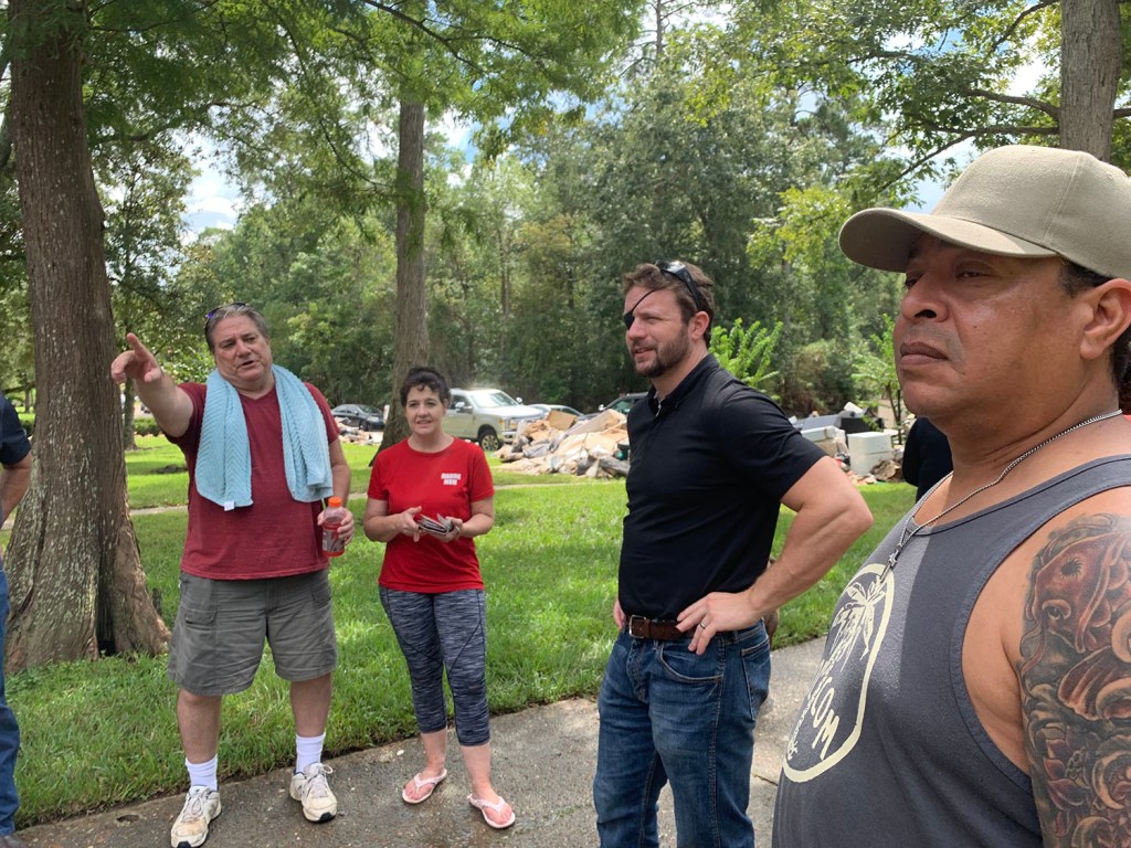
The floods were important enough for the Harris County Judge Lina Hidalgo; Dave Martin, the Mayor Pro Tem of the City of Houston; and US Congressman Dan Crenshaw to visit Elm Grove. But not Kathy Perry Britton.
Talk About Intrusiveness!
Sitting for a deposition in a comfortable conference room seems far “less intrusive” than having several feet of muddy floodwater invade your home, destroy your belongings, and ruin your vehicles. (Ms. Britton, if you want to know what “intrusive” is, see below.)
Abel and Nancy Vera live next to Woodridge Village (in the background beyond the trees). They burned out two power washers trying to get several inches muck off their driveway after Imelda. Vehicle destroyed in Imelda flood. Vera neighbor on Village Springs in Elm Grove.
Water in Keith Stewart’s home on Shady Maple after May 7th flood in 2019.
The hopes and dreams of children were dragged to the curb for the second time in five months after the September 19th flood in Elm Grove.US Congressman Dan Crenshaw talking with Elm Grove residents whose homes were destroyed in the September 2019 flood.
It’s curious that a US Congressman took the time to get personal, first-hand knowledge of the floods in Elm Grove and North Kingwood Forest. But Kathy Perry Britton could not. Perhaps picking wallpaper for her new model homes was more important.
1334 Days after Hurricane Harvey and 583 since Imelda
The thoughts expressed in this post represent opinions on matters of public concern and safety. They are protected by the First Amendment of the US Constitution and the Anti-SLAPP Statute of the Great State of Texas.
https://i0.wp.com/reduceflooding.com/wp-content/uploads/2019/09/Elm-Grove-9.19_68.jpg?fit=1500%2C1000&ssl=110001500adminadmin2021-04-24 06:59:582021-04-24 08:56:01Kathy Perry Britton Fights Being Deposed on Elm Grove Flooding
But four months later, the documents are still missing. Without explanation.
Either they got lost or were never developed in the first place. And no one will defend or explain the soil sampling in the documents that were produced.
Greg Arthur, Liberty County Precinct 2 Commissioner, won’t talk.
David Douglass, the Liberty County Engineer, won’t talk.
Louis Bergman, the former Liberty County Engineer, won’t talk.
Trey Harris, the developer of Colony Ridge, won’t talk.
Earnest Bailes, Liberty County’s state rep won’t talk.
Phil Struble, CEO of Landplan Engineering, won’t talk.
Enter Wayne Dolcefino, Investigator Extraordinaire
Wayne Dolcefino, formerly one of the country’s foremost investigative journalists and now a private investigator for the Plum Grove City Council, picked up the scent of a coverup. And he’s running it to ground…all the way to the Liberty County Courthouse and the headquarters of Landplan Engineering in Kansas. Landplan served as the engineering company for the Colony Ridge developer.
Simon and Garfunkle’s 1965 hit The Sounds of Silence became the theme song for Dolcefino’s latest exposé. In the 13-minute video, Dolcefino asks officials difficult questions about persistent problems that have driven off half of tiny Plum Grove’s population in the last few years.
I never get tired of watching Dolcefino wave his microphone in front of people who walk away to avoid answering questions.
For those who enjoy hard-hitting investigative journalism that speaks truth to power, this is a must-view video.
When it’s all over, you’ll ask yourself the biggest question of all: “Are these officials protecting the people who elected them or each other?”
We may soon find out. I interviewed Dolcefino this afternoon. He told me that his company, Dolcefino Consulting, is filing criminal complaints against State Representative Earnest Bailes and Commissioner Greg Arthur for failure to produce records requested under the Texas Public Information Act.
Keep your eye on this one. It has the potential to affect cozy relationships between developers and officials throughout the state.
Posted by Bob Rehak on 4/23/2021 based on a video by Wayne Dolcefino
1333 Days after Hurricane Harvey
The thoughts expressed in this post represent opinions on matters of public concern and safety. They are protected by the First Amendment of the US Constitution and the Anti-SLAPP Statute of the Great State of Texas.
https://i0.wp.com/reduceflooding.com/wp-content/uploads/2021/04/20210423-Screen-Shot-2021-04-23-at-1.32.20-PM.jpg?fit=1200%2C797&ssl=17971200adminadmin2021-04-23 14:40:532021-04-23 16:39:28Silence: Liberty County, Colony Ridge, Landplan Engineering Remain Mute on Missing Documents
Tuesday, I posted about three Harris County Flood Control District (HCFCD) floodwater-detention projects in construction on Greens Bayou. But HCFCD and the Army Corps recently completed three more. All three in the latter category started in 2015 – before the flood bond.
Magnitude of Recent Mitigation Investment on Greens
Looking at all six (in construction + recently completed) helps one understand the magnitude of investment in this watershed during the last six years.
The combined cost of all six projects totals more than $222 million.
The map below shows the locations of the recently completed projects in black; those still in construction are red. This post will focus on #4, #5 and #6 below.
#4, #5 and #6 represent three projects started in 2015 and recently completed.
#4: Greens Bayou Federal Flood Risk Management Project
The Greens Bayou Federal Flood Risk Management Project, also known as the Antoine Stormwater Detention Basin, lies just east of the Cutten Basin, discussed Tuesday. The U.S. Army Corps of Engineers Galveston District (Corps) and Harris County Flood Control District broke ground in 2015. Phase I cost $58 million. Phase II cost $21.4 million. And channel improvements cost $5.7.
Location of stormwater basin shown in yellow. Cutten basin is to left. Orange brackets show scope of channel improvements.
Phase I included approximately 3.7 miles of channel conveyance improvements from Cutten Road to Veterans Memorial Drive and approximately 108 acres of stormwater detention storage near the intersection of Antoine Drive and Beltway 8.
Phase II construction began in late 2016. It included completion of the north cell of the basin, located north of West Greens Road and excavation of the south cell, which is located south of West Greens Road.
From Google Earth Pro. Most recent satellite image is from 2/11/2019. For more recent construction shots, see below.
The Corps designed and built the project. It also planted trees, shrubs, and grasses on disturbed areas. These features will improve stormwater quality, support wildlife and provide opportunities for recreational benefits.
West Greens Drive bisects the Antoine basin, dividing it into two parts. However, box culverts connect them and they function as a single detention pond. The completed basin holds approximately 1,650 acre-feet, or 538 million gallons of stormwater. To put that in perspective, it holds a foot of rain falling over a 2.5 square mile area, or half a foot falling across 5 square miles!
Looking SW at the Antoine Stormwater Basin on Greens Bayou. Greens Drive bisects the project. Beltway 8 North is in background. Greens Bayou flows diagonally through the frame from right to left. Photographed on 4/22/2021
As part of a cost sharing arrangement, the Flood Control District purchased the 138-acre detention basin site. HCFCD also acquired other property and easements, and relocated utilities. The District will maintain the basin and channel in perpetuity.
#5: Kuykendahl Stormwater Detention Basin
Kuykendahl Stormwater Detention Basin sits on a 288-acre property near Kuykendahl Road and Ella Boulevard along an unnamed tributary of Greens Bayou.
The Kuykendahl Basin is the top purple area.
Contractors removed 3.61 million cubic yards of soil from the site. It holds 2,325 acre-feet, or 757.6 million gallons of stormwater. That’s a foot of rain falling across 3.6 square miles, or half a foot falling across 7.2.
2019 satellite image from Google Earth Pro of Kuykendahl Basin still under construction.
Following construction, contractors planted 22.19 acres of native tree and shrubs, and 12.79 acres of stormwater quality-treatment wetlands. They also created 14.04 acres of other wetlands to replace those impacted by construction.
What the Kuykendahl Basin looks like today, complete with picnic area.
Native, woody, riparian vegetation stabilizes banks, shades water, and creates habitat for birds.
FEMA awarded $39.2 million to the Harris County Flood Control District, under the Hurricane Ike Hazard Mitigation Grant Program (HMGP), for construction of this and another stormwater detention basin (see #6 below). The Flood Control District contributed matching funds for both projects.
Ceres Environmental Services Inc. constructed the two basins for $63.7 million. Combined, they were the largest construction contract ever managed by the Flood Control District up to that time. The two basins reduced or removed flooding risks and damages from more than 1,100 structures along Greens Bayou. “Avoided damage” exceeds $90 million in every flood.
Both projects (#5 and #6) are part of Progress Greens, a suite of flood damage reduction projects in the Greens Bayou watershed. All projects under the Progress Greens umbrella will function together to reduce flooding risks and damages for residents and businesses within the 213 square miles of the Greens Bayou watershed.
#6: Glen Forest Stormwater Detention Basin
The Glen Forest Stormwater Detention Basin lies southeast of the Kuykendahl Basin on a 160-acre site east of Interstate 45 and slightly north of Beltway 8. See P500-08-00 in the map below.
The Glen Forest project is at the purple location on the right.
The Glen Forest Basin project removed approximately 2.15 million cubic yards of soil in three connected cells. The completed basin holds approximately 894 acre-feet, or 291.3 million gallons of stormwater. That’s 1.4 square miles one foot deep or 2.8 square miles a half foot deep.
2019 satellite image from Google Earth Pro of Glen Forest Detention Basin at Beltway 8 North and 45while still under construction.
Basin design included 2.75 acres of native tree and shrub plantings and 0.81 acres of stormwater quality treatment wetlands.
Natural-channel design features, such as those in #5 above, provide environmental and water-quality enhancement.
The finished project today. Looking WNW from Imperial Valley Drive and Greens Road toward I-45 in background.
Regulation Vs. Mitigation
Areas both up and downstream from these ponds have extremely high-density commercial, industrial and residential development. Drive up Kuykendahl or Imperial Valley, for instance, and you will find mile after mile of apartment complexes. There’s little room for water to soak in during rainstorms.
More sensible development regulations that mandated onsite detention ponds when this area was being built might have prevented a lot of flood damage and heartbreak. Mitigating flood issues is always far more expensive, difficult and time consuming than preventing them. And many times, mitigating them after the fact is not even possible because of the shortage of land.
Value of Coalitions and Cooperation
Projects like the three above don’t happen without the combined efforts of elected representatives at the county, city, state and federal levels, plus community groups such as the Greens Bayou Coalition (GBC).
According to Jill Boullion, former director of the GBC, “The GBC advocated for $55 million in USACE funding from 2009 to 2015 for the Antoine Basin (Project #4) alone. We made many trips to DC, Galveston and Dallas to meet with elected officials, US Army Corps, Office of Management and Budget, and others. The Obama administration finally approved the funding! That was my first advocacy project and, boy, did I learn a LOT!!!”
The moral of that story: never underestimate the value of coalitions and cooperation in moving these projects forward.
Posted by Bob Rehak on 4/22/21
1332 Days since Hurricane Harvey
https://i0.wp.com/reduceflooding.com/wp-content/uploads/2021/04/20210422-DJI_0502.jpg?fit=1200%2C900&ssl=19001200adminadmin2021-04-22 13:46:222021-04-22 15:33:46Three More Major Projects on Greens Bayou Completed Recently by HCFCD, Army Corps
The Texas General Land Office will begin taking applications this Saturday, April 24, for Imelda assistance. $71,604,000 is available for Chambers, Harris, Liberty, Jefferson, Montgomery, Orange and San Jacinto Counties.
.Land Commissioner George P. Bush has announced locations of regional Homeowner Assistance and Reimbursement Programs (HARP) offices in advance of the 24th.
Applicants will be able to schedule an appointment in person in advance for the same day that applications will be available online.
Money Can Be Used For…
The money will cover repair or reconstruction of owner-occupied single-family homes and reimbursement up to $50,000 for certain out-of-pocket expenses incurred for reconstruction, rehabilitation, or mitigation.
Repayment of SBA loans is also eligible for reimbursement.
Car submerged during Imelda in Elm Grove. Photo courtesy of Allyssa Harris.
Appointments Required for In-Person Assistance
“Thousands of homes in Southeast Texas were damaged during during Imelda, devastating the livelihoods of countless Texans,” said Commissioner Bush. “In advance of the Homeowner Assistance and Reimbursement Programs application being released, the GLO is announcing locations of offices to provide residents with help applying for assistance.
Evacuation from Elm Grove during Imelda. Photo courtesy of Keith Stewart.
Where to Get Help
All applicants must make an appointment before visiting an office location.
Appointments will ensure proper capacity under COVID-19 restrictions. Applicants may request additional hours.
Harris County Location: St. Mark’s United Methodist Church 3811 N Main St, Baytown, TX 77521-3305
Montgomery County Location: North Montgomery County Community Center 600 Gerald St, Willis, TX 77378-3477
Chambers County Location:Chambers County Municipal Building 211 Broadway, Winnie, TX 77665-7781
San Jacinto County Location: Coldspring Area Public Library 14221 State Hwy 150 West, Coldspring, TX 77331
Jefferson County Location: First City Building 505 Orleans Street, Beaumont, TX 77701 Hours: By appointment only: Monday – Friday 8:00am – 5:00pm By appointment only: Saturday 8:00am – 12:00pm
Orange County Location: Orange County Convention and Expo Center 11475 FM 1442, Orange, TX 77630-5227
Pop-up Intake Locations Hours: All by appointment only Phone Number: 844-484-4277 (844-484-HARP)
Main Regional Office: Phone Number: 844-484-4277 (844-484-HARP)
Liberty County residents are eligible. An office in Liberty County may be announced in the future. For now, work through the main regional office above (in Beaumont).
Online, Email, Phone Assistance
Interested homeowners may also visit http://recovery.texas.gov/harp to apply online or download a printable version of the application.
Additionally, applicants may email the GLO at cdr@recovery.texas.gov or call 1-844-893-8937 to get help applying.” Up to date office locations and additional information are available at http://recovery.texas.gov/harp.
Before You Apply, Understand These Things
A single application can be submitted for reimbursement AND repair assistance.
However, an application must be submitted along WITH required documents for consideration.
HARP is “first-come, first-served,” and all homeowners are encouraged to apply immediately.
Households applying for reimbursement that do not meet the low-to moderate-income (LMI) threshold will be processed after the first six months from application opening, but may receive construction assistance prior to then, based on their application date.
HARP is only available for the homeowner’s primary residence.
Potential applicants can also find in-person assistance at regional HARP offices serving their area. In addition to a main office in each region, each county will have at least one application drop off location or satellite office. Additional satellite offices and application intake locations may be announced in the future and will be viewable at http://recovery.texas.gov/harp.
Posted by Bob Rehak on 4/21/21 based on information provided by the Texas General Land Office
1331 Days since Hurricane Harvey and 580 since Imelda
https://i0.wp.com/reduceflooding.com/wp-content/uploads/2019/10/Stewart-Evac-9.19.19-e1619020734162.jpg?fit=999%2C739&ssl=1739999adminadmin2021-04-21 11:11:312021-04-21 16:14:12GLO Announces Homeowner Assistance, Reimbursement Programs for Imelda