Instead, regular smaller rains kept the lake close to its monthly averages. Neither drought nor excessive heat caused lake levels, property values, business or tax revenues to plummet. Everything functioned much as it normally has since Lake Conroe was built in 1973.
Lake Stayed Near Monthly Averages
In the two months between April 1 and May 31, the lake only dropped below 200 feet by an inch or two for three or four days and then promptly refilled. In fact, at the end of May, 2.5 inches of rain caused the lake to rise above its seasonal norm, prompting a second release.
Two releases and smaller, spread-out rains kept the Lake Houston Area safe and Lake Conroe close to its monthly averages(200.32 for April and 200.44 for May; see below).Source: SJRA Board Presentation 7/23/20. Lake Conroe seasonal levels by month for 46 years. In April and May, Lake Conroe averages 200.32 and 200.44 respectively.Source SJRA Board Presentation.
During that time, the Lake Houston Area never flooded. Yet Lake Conroe was above its monthly average for the first three weeks of April. And it was only down about three inches for about three weeks in May.
The assertion that Lake Conroe is “normally” at 201 is a myth. That is the level at which the SJRA normally starts releases. Due to evaporation, which can take an inch a day, the lake is almost always well below that. A more accurate term for 201 would be “full pool.”
River Levels Up Slightly, but No Flooding
West Fork river levels rarely rose more than 2 or 3 feet even when rainfall was added to the release rate from Lake Conroe.
Release rates averaged about 600 cubic feet per second (cfs) and rarely exceeded 1000 cfs.
If the exercise proved anything, it was that releasing at those rates didn’t flood anyone.
River levels vs. rainfall for the last two weeks of the spring lowering.Source: SJRA Board Presentation 7/23/20.
Fall Lowering Starts This Saturday
The Houston Area lucked out with Hanna. Had the storm veered towards us, we would have received the torrential rains that swamped the Valley.
This fall, the lowering will be split into two phases: to 200 feet in August and 199.5 in September. The City of Houston has the right to call for an additional half foot in the event of a named storm.
Restatement of SJRA lake lowering policy for this year.Source: SJRA Board Presentation 7/23/20.
Even though Hanna missed us and Gonzalo fizzled, the next storm may not.
Finally, note that the target level for August (200 feet) is about an inch ABOVE the normal monthly average. So if evaporation does its job, the SJRA will not have to lower the lake.
Posted by Bob Rehak on 7/27/2020
1063 Days after Hurricane Harvey
https://i0.wp.com/reduceflooding.com/wp-content/uploads/2020/07/Release-Vs.-Lake-Levels.jpg?fit=1500%2C836&ssl=18361500adminadmin2020-07-27 16:12:472020-07-27 16:12:58SJRA Report on Spring Lowering of Lake Conroe
Overnight, TD 8 turned into Tropical Storm Hannah. Hannah’s track continues to take it toward Corpus and the Rio Grande Valley. The shift in direction compared to earlier projections means wind and rainfall threats to Houston are reduced. However, tropical storm warnings remain up for most of the Texas coastline, including San Luis Pass to the Rio Grande Valley.
Rainfall Amounts
Hanna should produce heavy rains, but the heaviest will fall in South Texas.
While portions of south Texas could see 10 to 15 inches of rain this weekend, rainfall amounts in the Houston area should average 3-5 inches along the coast and 1-3 inches inland.
Jeff Lindner, Harris County Meteorologist
Infrared imagery shows building of Hannah.
Rainfall accumulation for storm durationTotal accumulation in north Harris County is likely to be only 1-2 inches from Hannah.
Of course, that should hold down the risk of flash flooding in the Lake Houston Area, but Lindner says the Weather Service will likely issue flash flood warnings for portions of SE Texas later today. NOAA currently gives the north Houston area only a marginal chance of flash flooding.
Houston has only a 5-10% chance of flash flooding from Hannah.
Hannah Could Strengthen to 65 MPH
National Hurricane Center expects Hanna to strengthen and bring tropical-storm-force winds to portions of the Texas coast. NHC brings Hanna to a 65mph tropical storm at landfall. How long it takes any inner core to form today will determine if Hanna could potentially become a weak hurricane as suggested by some of the hurricane models.
Most tropical storm force winds should miss Houston.
Winds in the Lake Houston Area will not be that strong, of course, but could still reach 20 mph, according to forecasters.
Not the Weekend for Offshore Boating
Lindner says, “Wave heights near the center of Hanna will build today. As the system intensifies, waves could reach 10-15 ft tonight. Some of this wave action will move toward the upper TX coast with seas building today into the 4-6 foot range and 6-9 foot range tonight into Saturday. Large swells generated by the system will result in wave run-up and elevated tides of 1-3 feet starting later today and lasting into much of Saturday along the upper and mid TX coast. Minor coastal flooding will be possible at times of high tides in the typical sensitive areas along the coast.”
Forecast track shows Hannah coming onshore Saturday at 1PM in south Texas.
In summary, the brunt of the storm should miss us. But we will still get sideswiped.
Every once in a while, thoughts collide in a way that makes you see the world more clearly. Such a collision happened today. I suddenly realized that Texas, the state that leads the nation in billion-dollar, weather-and-climate related disasters, also has many developers plus city and county officials pushing back against higher minimum drainage standards that would reduce flooding. At a time when those disasters are increasing in frequency!
How Proposed Drainage Standards Will Affect Developers
I replied, “The proposed changes would force developers in the future to install detention ponds and storm drains large enough to help reduce flooding. It would also prohibit them from reducing the floodwater storage capacity of the 500 year floodplain. Finally, it would force them to raise the level of homes above the 500-year floodplain or flood-proof them.”
Then I added, “From a flood prevention point of view, these are all good things. But from a developer’s point of view, they add expense. If you buy a home in an area that complies with these standards, it will probably mean a higher-priced, but much safer home. I hear that developers and some civic officials are already pushing back against these proposed changes.”
Natural Disaster Costs, Frequencies
After sending the reply, I went to the NOAA site to find information about natural disasters, their costs, their frequency and their primary locations.
The last decade had twice as many billion-dollar weather disasters as the previous decade and four times more than the decade of the 1980s. The last five years had 69% of all such disasters in the entire 40 year period.
Tropical Cyclones and flooding comprised 29.5% all these billion-dollar disasters.
Reason for Increasing Costs, Even After Adjusting for Inflation
In explaining these rising costs, NOAA says, “These trends are … complicated by the fact that much of the growth has taken place in vulnerable areas like coasts and river floodplains. Vulnerability is especially high where building codes are insufficient for reducing damage from extreme events.”
Texas Leads Nation
And who leads the nation in billion-dollar, weather-and-climate-related disasters? Texas.
Connecting Some Tragic Dots
So there you have it.
The state with the most billion-dollar disasters has many developers and civic leaders pushing back against higher minimum drainage standards at a time when major weather disasters are increasing.
New Northpark Woods development in Montgomery County next to San Jacinto West Forkand its sand pits.
Posted by Bob Rehak on 6/8/2020
1014 Days after Hurricane Harvey and 263 after Imelda
https://i0.wp.com/reduceflooding.com/wp-content/uploads/2020/06/map_events_per_state_cumulative.png?fit=974%2C650&ssl=1650974adminadmin2020-06-08 16:19:232020-06-08 16:48:46Why Does the State that Leads the Nation in Billion-Dollar Weather Disasters Resist Minimum Drainage Standards?
Confidence is increasing that a tropical system will be moving northward through the Gulf of Mexico by this weekend. It will threaten some portions of the US Gulf coast. However, the National Hurricane Center advises that it’s still too early to pinpoint where the greatest impacts may be.
Harris County Flood Control Meteorologist Jeff Lindner advises residents along the Gulf coast to fully stock hurricane kits and have plans ready to enact. “By Sunday morning, it is likely there will be a tropical storm in the central Gulf of Mexico,” he says.
Source: NHC. Indicates conditions as of 10a.m. CDT on 6/2/2020.
At This Moment…
Slow-moving Tropical Depression Three (TD 3) is still in the Bay of Campeche and:
CLOSE TO TROPICAL STORM STRENGTH
LIFE-THREATENING HEAVY RAINFALL AND FLOODING CONTINUES OVER PORTIONS OF MEXICO AND CENTRAL AMERICA.
Summary of Watches and Warnings
A Tropical Storm Warning is in effect for Campeche to Puerto de Veracruz. A Tropical Storm Warning means that tropical storm conditions are expected somewhere within the warning area, in this case within the next within 24 to 36 hours.
Current Location and Conditions
At 1000 AM CDT (1500 UTC), the center of Tropical Depression Three was located near latitude 19.5 North, longitude 92.6 West. The depression is moving toward the west near 3 mph (6 km/h). The depression is forecast to move slowly southwestward or southward this afternoon and tonight, and meander over the southern Bay of Campeche through late Wednesday.
NHC forecasts the center of the cyclone to remain near the coast of the southern Bay of Campeche tonight through Thursday. Maximum sustained winds are near 35 mph with higher gusts. Some strengthening is forecast during the next 48 hours, and the depression is likely to become a tropical storm today.
USAF plane recorded flight-level winds of 44 kts.
The minimum central pressure reported by an Air Force Hurricane Hunter plane is 1005 mb (29.68 inches).
TD 3 A Rainmaker
NHC expects TD 3 to produce total rain accumulations of 10 to 20 inches with isolated maximum amounts of 25 inches over parts of the Mexican states of Tabasco, Veracruz, and Campeche.
The depression is also expected to produce total rain accumulations of 10 to 15 inches over northern Chiapas and other Mexican states, Quintana Roo and Yucatan.
Additional rainfall of 10 to 15 inches, with isolated amounts of 25 inches is expected along the Pacific coasts of Chiapas, Guatemala, and El Salvador. Some of these Pacific locations received 20 inches of rain over the weekend, and storm total amounts of 35 inches are possible.
Rainfall in all of these areas may produce life-threatening flash floods and mudslides.
Wind Probabilities
Tropical storm conditions are expected to first reach the coast within the warning area tonight.
Source: NOAA. Probably Tracking of TD 3 and earliest arrival of tropical storm force winds.
It is important for users to realize that wind speed probabilities that might seem relatively small at their location might still be quite significant. A chance exists that a damaging or even extreme event could occur that warrants preparations to protect lives and property.
Key Takeaways
Deadly flooding has already occurred in portions of Guatemala and El Salvador, and the depression is expected to bring additional heavy rainfall to portions of southern Mexico, Guatemala, Honduras, and El Salvador, which could cause life-threatening flash flooding and mudslides.
Tropical storm conditions are expected along the coast of Mexico where a tropical storm warning is in effect.
The system is forecast to begin moving northward across the Gulf of Mexico by this weekend. However, it is too soon to specify the location and timing of any potential impacts along the U.S. Gulf Coast. Interests in these areas should monitor the progress of this system through the week and ensure they have their hurricane plan in place as we begin the season.
Houston Forecast For the Week
Today, mostly sunny with light winds. Expect similar conditions on Wednesday, with the possibility of scattered showers and highs of around 90 degrees.
The second half of the week will see warmer weather as high pressure continues to build over the area. We are likely to see high temperatures in the low- to mid-90s. Mostly sunny skies and only slight rain chances during the afternoon hours. Nights will be warm and muggy, in the 70s.
The location of a high pressure system to our north late in the week will likely determine the track of TD 3. Monitor forecasts closely.
Posted by Bob Rehak on 6/2/2020
1008 Days after Hurricane Harvey
https://i0.wp.com/reduceflooding.com/wp-content/uploads/2020/06/image002.png?fit=897%2C736&ssl=1736897adminadmin2020-06-02 11:31:072020-06-02 11:31:19TD 3 Close to Tropical Storm Strength; Dumping Torrential Rains Over Mexico, Central America
Update: This post was created at 10 a.m. As of 1 p.m. the National Hurricane Center upgraded the chances of tropical development another 10% to 90%.
Pacific Tropical Storm Amanda moved into Central America and southern Mexico last weekend. It is now poised to re-emerge into the Gulf of Mexico and may form another tropical system. Since yesterday morning, the National Hurricane Center (NHC) upgraded the chances of formation within the next two days from 40% to 80%. The NHC also upgraded chances of formation within five days from 50% to 80%.
NHC expects this large area of disturbed weather to move northwestward over the southeastern portion of the Bay of Campeche later today or tonight. Environmental conditions there are expected to be conducive to support development.
A new tropical depression is likely to form within within the next day or so.
National Hurricane Center
The system is moving around the northern side of a nearly stationary central American monsoon trough.
Heavy Rainfall for Southern Neighbors For the Moment
Regardless of tropical cyclone formation, heavy rainfall should continue over portions of southern Mexico, Guatemala, El Salvador, Belize, and western Honduras during the next few days.
System Likely to Loop in Bay of Campeche Before Moving North
The tropical system will loop or remained stalled in the Bay of Campeche (the bay between the Yucatan and Mexican mainland) for the next 2-4 days. After that, most models take it toward the US Gulf coast, but there is little agreement among the models at this early stage of formation. Currently, they indicate landfall anywhere between Mexico and Florida. We should have a better indication of the track toward the middle of this week.
Official Start of Hurricane Season Today
Today marks the first day of the Atlantic hurricane season, which will run until November 30. The list of names for 2020 follows:
Two tropical storms, Arthur and Bertha, already formed this year in May. The next named storm that develops this season will be Cristobal.
Harris County Flood Control meteorologist Jeff Lindner advises residents along the US Gulf coast to closely monitor the progress of this system. “Now is a very good time to review plans and fully stock preparation kits,” he says.
Posted by Bob Rehak on 6/1/2020 at 10am with thanks to NHC, HCFCD and Univ. of Wisconsin
1006 Days after Hurricane Harvey
https://i0.wp.com/reduceflooding.com/wp-content/uploads/2020/06/20201531306_GOES16-ABI-gm-GEOCOLOR-1000x1000-1.jpg?fit=1000%2C1000&ssl=110001000adminadmin2020-06-01 09:50:542020-06-01 13:40:19NHC Upgrades Chances of Topical System Formation in Gulf to 80%
Last week, a friend sent me some links to NOAA’s coastal flood exposure mapper and several related sites. The NOAA tools have inland applications, too. Full functionality extends to the northern part of Harris County. The NOAA site combines so many different tools in the flood exposure mapper (and related sites), that they could become the “go to” sites to determine flood risk for many in the Houston region.
Their main value: the ability to overlay many different kinds of information on one map to precisely render the geospatial relationships, and easily share what you see.
The flood-exposure mapper site:
Incorporates FEMA’s flood risk zones
Identifies many more levels and types of risk, and their extent (see below)
Lets you change base layers, so you can view risk zones over maps or satellite images
Lets you toggle layers on and off, and vary their opacity, to help explore risks in your area
Allows you to share the map on your screen by simply copying the web address (as I did in the embedded links below).
17 Different Layers Available
You can render seventeen different types of information and overlay them in different layers.
HAZARD LAYERS
Coastal Flood Hazard Composite
High Tide Flooding
FEMA Flood Zones
Tsunami
Storm Surge
Sea Level Rise
SOCIETAL EXPOSURE
Population Density
Poverty
Elderly
Employees
INFRASTRUCTURE EXPOSURE
Development
Critical Facilities
Development Patterns
ECOSYSTEM EXPOSURE
Natural Areas and Open Space
Potential Pollution Sources
Natural Protection
Wetland Potential
EXAMPLES
Flood Zones vs. Critical Infrastructure
Say you wanted to see where critical infrastructure facilities, such as schools, hospitals, and police and fire stations, are in your neighborhood relative to mapped flood zones. Turn on the FEMA layers. Turn on Critical Infrastructure. Vary the opacity to suit your taste. And voila. You can see where everything is. Location could affect first responder response time in a flood, your ability to get to a hospital, or your ability to get kids at school. Also see it below.
Flood zones versus critical infrastructure in the Lake Houston Area.
Flood Zones Vs. Population Density
Want to map population density against flood zones?
Development Density and Time Frame
Curious about when certain areas were developed, and the intensity of that development
Green Infrastructure
Want to see how much green space developers left in your community?
289 Possible Searches
Only two layers at a time can be active. But with 17 different layers, you have 289 possible searches for any given area.
Note: some, but not all layers contain information for Montgomery County, Liberty County and other counties that have no coastal exposure. You just have to experiment.
Helpful Background Information
Puzzled about what some of the terms mean and how they relate to flooding?
Click on the info button for “Employees” and you will see this explanation. “This map shows the range in the number of employees for U.S. Census block groups (or geographies) that work in or near coastal flood-prone areas. Some of the most devastating disaster impacts to a community include the loss of income due to business interruption and the loss of jobs as a result of business closures. It is also important to know where people are located should a hazard event occur during work hours.”
Wondering what “natural protection” has to do with flooding. Click the info button. The following explanation pops up. “Natural areas and open space adjacent to development can buffer and protect against flooding. Wetlands hold floodwaters, reduce wave heights, capture sediments, and reduce erosion. Beaches and dunes absorb wave energy, and other natural areas such as forests and grasslands provide porous surfaces that can absorb, store, and slow water. Protecting these natural areas will ensure that communities continue to receive these benefits; however, with sea level rise, these habitats will need to move landward, so in addition, communities will want to assess and protect surrounding land to help facilitate this process.”
These are very powerful, well-laid out tools within an easy-to-use, intuitive interface. It’s actually fun to explore.
Sea-Level-Rise Visualizer
Speaking of sea level rise, without taking a political stance on global warming, NOAA provides an interesting inundation map/viewer. It lets you vary the amount of sea-level rise by 1 to 10 feet and shows how much coastline will be lost for any given amount of rise. You’ll be pleased to know that Lake Houston is not in danger, even with 10 feet of rise.
The sea-level-rise viewer also contains a high-tide flooding map, a vulnerability map, a marsh migration map and more.
Most of these sites are geared toward professionals, such as flood plain managers, developers, planners, government employees, and real estate people. However, that should not deter residents and home buyers. Each of these related sites offers excellent tutorials.
I would also say that during COVID-school shutdowns, science teachers and parents of teenagers have an excellent learning opportunity with these tools. There’s enough here to keep bored students interested for days. It can be something you explore together as a family.
More Information About Nature Based Solutions
For flood engineers, planners, developers, regulators and serious flood geeks, NOAA also offers the following:
After the Easter weekend, the San Jacinto River Authority (SJRA) started its seasonal-release plan. The river authority is currently releasing at a rate of 529 cubic feet per second (CFS) from Lake Conroe. At that rate, the lake should reach its target level of 200 feet above sea level by the end of April, according to Jace Houston, general manager of the SJRA.
SJRA Seasonal Release on 4/15/2020. One tainter gate open six inches releases a slow, steady stream of 529 cfs. Image courtesy of SJRA.
The slow rate of release avoids flooding downstream property and the lower lake level provides additional capacity in the lake. That additional capacity provides a buffer against flooding for downstream residents.
About Seasonal Lake Lowering Policy
Houston said the River Authority will hold the lake at 200 feet through the end of May, then allow it to reach its normal level for most of the summer.
Lake Conroe actually reached 200.75 feet before SJRA began its seasonal lowering this week.A reduction of .14 feet equates to about one and two-thirds inches of lowering so far.
At 200.75 feet, Lake Conroe was actually above its highest average monthly level for the year, which is 200.44 feet in May. The normal level for April is 200.32 feet.
Lake Conroe seasonal levels by month. From SJRA board presentation by Chuck Gilman in January.
Earlier this year, a bitter fight broke out between upstream and downstream property owners over the seasonal lake lowering policy. The SJRA board decided to extend the lake lowering plan, but modify it. In the fall, they will let the City of Houston, which owns two-thirds of the water in the lake, decide whether to take the lake down below 199.5 feet.
Despite the start of the seasonal release and last week’s rains, the level of Lake Houston has declined this week. And rivers are far from flooding.
Normal level for Lake Houston is 42.5 feet, but City is still lowering lake for spillway maintenance.
Uncertain Weather for This Weekend
Jeff Lindner, Harris County meteorologist, predicts that storms this weekend could bring several inches of rain. “With the Gulf of Mexico water temperatures running several degrees above average for this time of year, winds blowing off the Gulf will need little time to supply a rich moisture-laden air mass.”
The NWS predicts a 30-40% chance of showers and thunderstorms for this weekend as a front passes. However, Lindner notes, models diverge widely in their predictions. The Global Forecast System (GFS model) predicts that most rain will happen over the Gulf with little impact to land.
However, the European Medium Range Forecast Model (ECMWF) predicts a very wet weekend with several rounds of storms and several inches of rainfall for much of southeast Texas.
https://i0.wp.com/reduceflooding.com/wp-content/uploads/2020/02/20200220-RJR_8690.jpg?fit=800%2C1200&ssl=11200800adminadmin2020-04-15 13:26:562020-04-15 20:58:42SJRA Starts Seasonal Release to Lower Lake Conroe
Reasons: unusually warm seawater in the Atlantic and the likely LACK of an El Niño in the Pacific. El Niño in the Pacific usually sets up wind shear that tears apart storms in the Atlantic. Said another way, they help keep tropical storms from developing into full-force hurricanes. But without El Niño, the lack of shear allows more storms to develop and creates active hurricane seasons.
Source: NOAA, From April 2, 2020. Shows most of Atlantic has above-normal sea-surface temps, and that temps immediately offshore the upper Texas and Louisiana Coasts are now 4-5 degrees above normal.
CSU predicts 18 named storms will develop.
AccuWeather released its hurricane season predictions a week earlier. They predict 14-18 names storms. Of those, seven to nine will likely become hurricanes, and two to four are likely to hit the U.S. mainland.
NOAA should issue its forecast in late May.
Hurricane season extends from June 1 to November 30.
March Warmth Unrelated to Hurricane Season
Jeff Lindner, Harris County Flood Control’s meteorologist, says that the unusually warm March that south Texas just experienced (about 8 degrees above normal) will have little effect on tropical storm formation. “There is some correlation with a warm Gulf of Mexico and severe weather and flooding along the Gulf Coast during the spring months. But there is little to no correlation to tropical activity in the Gulf during summer months.”
3-4 Inches of Rain Possible in Next 5 Days
Speaking of Spring rains, Lindner also predicts a stormy weather pattern will set up over our area for the next 5-7 days. He says “some severe weather and heavy rainfall will be possible.”
“Widespread rainfall amounts of 1-2 inches with isolated totals of 3-4 inches will be possible between this afternoon and Saturday,” says Lindner. He predicts the heaviest rainfall across area north of I-10. Storms could train, producing the higher rainfall amounts. But Lindner also adds, “It has been dry of late and the soil can take several inches of rainfall as long as it is not all at once.” So no one is talking about flooding at this point.
NOAA predicts a slight chance of severe storms Friday evening, mostly west of Houston.
Here’s where NOAA predicts the heaviest rains to fall during the next 5 days and what the total accumulations should be.
Posted by Bob Rehak on 4/2/2020
947 Days since Hurricane Harvey
https://i0.wp.com/reduceflooding.com/wp-content/uploads/2020/04/atl_anom.gif?fit=800%2C737&ssl=1737800adminadmin2020-04-02 12:59:582020-04-02 13:06:34“Above-Average” Hurricane Season Predicted This Year
On February 20, NOAA announced computing upgrades that will enable new and improved weather and climate forecasting. Significant upgrades to supercomputing capacity, storage space, and interconnect speed of its Weather and Climate Operational Supercomputing System will keep the agency’s supercomputing capacity on par with other leading weather forecast centers around the world.
Why We Need More Supercomputing Capacity
As good as weather forecasting has become, it can still go much further. That’s why this item caught my eye.
Triple Capacity, Double Storage and Interconnect Speeds
This increase in high-performance computing will triple the capacity and double NOAA’s storage and interconnect speed. It will help NOAA create better forecast model guidance. The keys: higher-resolution and more comprehensive Earth-system models that use larger ensembles, advanced physics, and improved data assimilation.
“We will restore America’s international leadership with the best weather forecasts, powered by the fastest supercomputers and world-class weather models,” said Neil Jacobs, Ph.D., acting NOAA administrator.
Two new Cray computers, an operational primary and backup, will be located in Manassas, Virginia, and Phoenix. The computers each have 12 petaflop capacity. They will become operational by early 2022 after code migration and testing.
New Total of 40 Petaflops
Coupled with NOAA’s other research and development supercomputers, which have a combined capacity of 16 petaflops, NOAA’s new prediction and research computing capabilties will reach 40 petaflops.
A petaflop is a unit of computing speed equal to one thousand million million (1015) floating-point operations per second.
Earth Prediction Innovation Center
The new computers will help advance research and development under NOAA’s emerging Earth Prediction Innovation Center (EPIC). They should make the U.S. Global Forecast System the best model in the world.
“Through EPIC, we have an opportunity to regain our footing as a world leader in global weather prediction. The system will foster partnerships with university and industry scientists and engineers to advance U.S. numerical weather prediction,” added Jacobs.
EPIC will make it easier for developers across all sectors to collaborate on improving the nation’s weather and climate models. It leverages combined skills and resources and lowers barriers for interaction. It does that through the use of cloud computing and a community modeling approach called the Unified Forecast Systemoffsite link.
Current Acquisition Will Lay Ground for Future Advances
“The National Weather Service ran a competitive acquisition to ensure we have the supercomputing power needed to implement all the great modeling advancements we anticipate over the next several years,” said Louis W. Uccellini, Ph.D., director of the National Weather Service. “This is an exciting time for all of us in the weather research and operations community, with bold changes on the horizon. We are making sure NOAA is ready.”
Posted by Bob Rehak on 2/27/2020 based on information provided by NOAA
912 Days since Hurricane Harvey
https://i0.wp.com/reduceflooding.com/wp-content/uploads/2020/02/Digital-Globe.jpg?fit=1200%2C744&ssl=17441200adminadmin2020-02-27 18:27:082020-02-27 18:32:29NOAA to Triple Supercomputing Capacity for Weather, Climate Forecasting
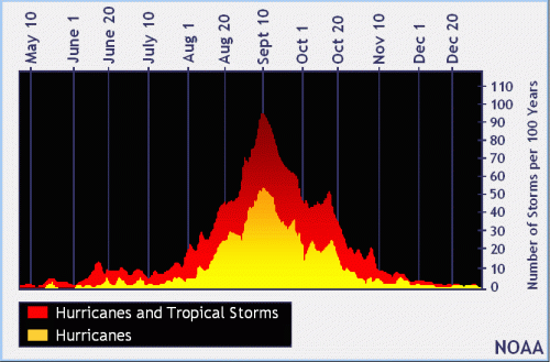
With two weeks left in August and no active tropical systems in the Atlantic, Caribbean or Gulf, I started wondering how this hurricane season stacked up against the average. Through the end of July, we had two named storms in the Atlantic. We also had six in the eastern Pacific, none of which threatened land. That makes a total of eight. How does that compare to a normal year? Below is a chart from NOAA. It shows the averages for tropical storms and hurricanes by month.
167 Years of Hurricane History
The first thing I noticed when looking at this table is the clear jump between July and August. Through the end of July, the averages for both tropical storms and hurricanes are below 1. That means the chances of NOT seeing one are greater than seeing one. However, August is where things heat up (pardon the pun). Your chances of seeing one are far greater than NOT seeing one.
Through the end of July, we exceeded the averages for The Atlantic and Pacific combined. But if you look at just the Atlantic, we are about on average, as the chart below shows.
Cumulative Number of Storms Per 100 Years in The Atlantic Basin.Source: NOAA
The official hurricane season for the Atlantic Basin (the Atlantic Ocean, the Caribbean Sea, and the Gulf of Mexico) is from 1 June to 30 November. As seen in the graph above, the peak of the season is from mid-August (now) to late October.
Current Outlook Clear
However, THIS August has been quiet so far. Season-to-date, we are still slightly above average, but the month of August is unusually quiet. We’re halfway through the month without any named storms in the Atlantic and NOAA expects no activity for the next five days.
Regardless, if you are the type to play the odds, so far this year Texans have to consider themselves lucky.
Lake Levels As of Mid-August
With that in mind, let’s look at what the San Jacinto River Authority (SJRA) and Coastal Water Authority are doing with Lake Conroe and Lake Houston to reduce the chance of flooding in the event of a major storm.
Both lakes are down about a foot. This creates an extra buffer against flooding by creating extra capacity within the lake.
The SJRA began lowering Lake Conroe on August 1. Normal level is 201 feet above sea level. As of this morning, Lake Conroe was at 200.03 feet and the SJRA continued to release water at a minuscule rate of 150 cubic feet per second. Evaporation is doing most of the work. The SJRA says the lake can lose up to an inch per day through evaporation in hot, dry weather, which we have had plenty of lately. You can always check the current lake level at SJRA.net.
The Coastal Water Authority is maintaining Lake Houston at 41.57 feet above sea level. Normal level is 42.38 feet. A recent lowering for dam maintenance combined with lack of recent rain and evaporation have all contributed to the current level.
The SJRA will continue releasing water at a rate that brings Lake Conroe down to 199 feet by September 1. The SJRA will maintain that level through the end of September, then allow the lake to gradually refill with rainwater until it reaches the normal level of 201 feet.
https://i0.wp.com/reduceflooding.com/wp-content/uploads/2019/08/peakofseason_sm.gif?fit=500%2C329&ssl=1329500adminadmin2019-08-14 11:52:152019-08-14 11:57:27How This Hurricane Season Compares to Others So Far