How This Hurricane Season Compares to Others So Far
With two weeks left in August and no active tropical systems in the Atlantic, Caribbean or Gulf, I started wondering how this hurricane season stacked up against the average. Through the end of July, we had two named storms in the Atlantic. We also had six in the eastern Pacific, none of which threatened land. That makes a total of eight. How does that compare to a normal year? Below is a chart from NOAA. It shows the averages for tropical storms and hurricanes by month.
167 Years of Hurricane History
The first thing I noticed when looking at this table is the clear jump between July and August. Through the end of July, the averages for both tropical storms and hurricanes are below 1. That means the chances of NOT seeing one are greater than seeing one. However, August is where things heat up (pardon the pun). Your chances of seeing one are far greater than NOT seeing one.

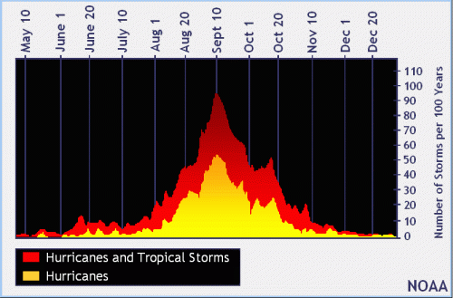
Distribution of Atlantic Storms by Month
Through the end of July, we exceeded the averages for The Atlantic and Pacific combined. But if you look at just the Atlantic, we are about on average, as the chart below shows.


The official hurricane season for the Atlantic Basin (the Atlantic Ocean, the Caribbean Sea, and the Gulf of Mexico) is from 1 June to 30 November. As seen in the graph above, the peak of the season is from mid-August (now) to late October.
Current Outlook Clear
However, THIS August has been quiet so far. Season-to-date, we are still slightly above average, but the month of August is unusually quiet. We’re halfway through the month without any named storms in the Atlantic and NOAA expects no activity for the next five days.

Regardless, if you are the type to play the odds, so far this year Texans have to consider themselves lucky.
Lake Levels As of Mid-August
With that in mind, let’s look at what the San Jacinto River Authority (SJRA) and Coastal Water Authority are doing with Lake Conroe and Lake Houston to reduce the chance of flooding in the event of a major storm.
Both lakes are down about a foot. This creates an extra buffer against flooding by creating extra capacity within the lake.
The SJRA began lowering Lake Conroe on August 1. Normal level is 201 feet above sea level. As of this morning, Lake Conroe was at 200.03 feet and the SJRA continued to release water at a minuscule rate of 150 cubic feet per second. Evaporation is doing most of the work. The SJRA says the lake can lose up to an inch per day through evaporation in hot, dry weather, which we have had plenty of lately. You can always check the current lake level at SJRA.net.
The Coastal Water Authority is maintaining Lake Houston at 41.57 feet above sea level. Normal level is 42.38 feet. A recent lowering for dam maintenance combined with lack of recent rain and evaporation have all contributed to the current level.
The SJRA will continue releasing water at a rate that brings Lake Conroe down to 199 feet by September 1. The SJRA will maintain that level through the end of September, then allow the lake to gradually refill with rainwater until it reaches the normal level of 201 feet.
Pre-emptive seasonal lowering helped avoid flooding last spring. Keep your fingers crossed!
Posted by Bob Rehak on 8/14/2019
715 Days since Hurricane Harvey


