Get Ready for the Rain Train
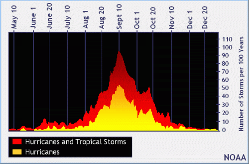
Forecasters predicted a higher than average hurricane season. We will find out whether they are right in the next three months – the peak of the season. But the rain train has already started.

The tropical wave that moved onshore yesterday produced 2 to 4 inches of rain over League City this morning.

Other Storms Already Stacking Up in Atlantic
Meanwhile, two more storms are stacked up out in the Gulf and Atlantic. (See below.) The National Hurricane Center gives the orange one a 40% chance of developing and red one a 90% chance in the next five days.


Tropical Wave Likely to Arrive Friday
NOAA says that a tropical wave currently over Cuba is producing a large area of disorganized showers and thunderstorms over western Cuba. NHC expects this system to reach the northwestern Gulf on Thursday and Friday. Tropical formation chance currently equals 40 percent.
Jeff Lindner, Harris County meteorologist, says, “Regardless of development, widespread showers and thunderstorms will begin to impact the upper TX coast as early as late Thursday evening. More likely the impact will be Friday and lasting into Saturday. Some of this rainfall will be heavy. Winds will increase into the 15-25kt range with seas building to 3-5 feet by late Thursday and likely higher on Friday.”
90% Chance of Formation for Atlantic Storm
NHC also expects that system midway in the Atlantic (now Tropical Depression 7) to get better organized. However they also say that less favorable conditions could limit additional development of the system by the weekend. Formation chance: 90 percent.
Here’s how it all looks on the GOES-East satellite imagery in earth colors. Note the system about to enter the Gulf and the steady stream of clouds rolling off the western coast of Africa and across the Atlantic.


I nicknamed the steady stream of clouds “the rain train.”
Trade Winds Powered Global Commerce for Centuries
Technically, though, they’re called the trade winds. The term has an interesting origin. For centuries, they powered trade between Europe and the Americas. This time of year, sailors from Europe heading to the Americas would first sail south to Western Africa. There, they would pick up the trade winds (visible in the photos above) that powered them west.
After completing their trade, they would head north along the Eastern Coast of the U.S. and pick up a return flow that would take them back to Europe.
It was a reliable, but often deadly route.
Of the 691 ships identified by the Spanish researchers that were lost between between 1492 and 1898, 91.2% were sunk by severe weather – mainly tropical storms and hurricanes.
Without satellites, hurricanes often caught them by surprise. The storms could snap their masts, at which point they would be “dead in the water.”
There’s an island off the coast of Honduras called Guanaja. The Spanish called it Isla de Los Pinos. Isle of Pines. It’s one of the few islands in the Caribbean with native pine trees. Columbus visited there on his fourth voyage. And according to local legend, Spanish sailors would often stop there after crossing the Atlantic to replenish their masts.
Posted by Bob Rehak on 7/21/2020, updated at 6:30 pm with info on TD7.
1057 Days since Hurricane Harvey


