The recent drought has reduced the rate of erosion under the Tree Lane/Bens Branch Bridge for now. But with wetter weather expected, we need to accelerate the repair effort. Recent pictures show the desperate need for repairs to the bridge. It’s next to Bear Branch Elementary School where more than 600 students attend grades K-5.
Power of Moving Water
The current state of this bridge and the area around it is a testament to the power of moving water … more than engineers designed the bridge to handle.
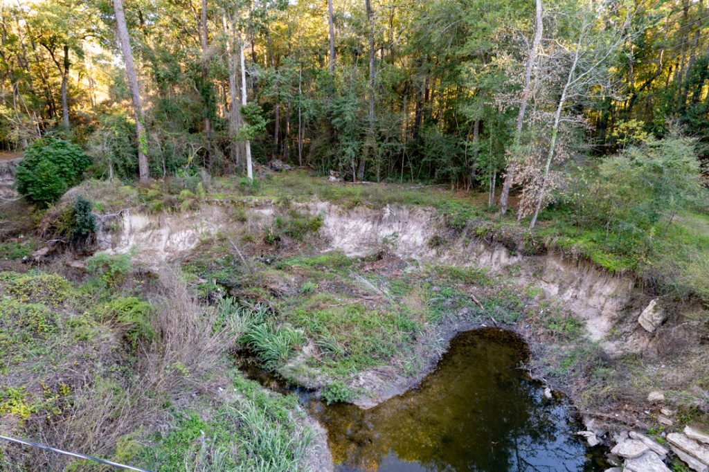
Water jetting under the bridge during storms has ripped away great slabs of concrete, eroded side walls, and partially blocked a storm drain outfall.
Condition of Tree Lane Bridge over Bens Branchon 11/24/23
It has also eroded the channel. Rip rap has done little to halt the erosion.
11/24/23. Condition of Tree Lane Bridge over Bens Branch.
Downcutting has exposed utility lines. And stormwater has carried chunks of concrete downstream like toothpicks.
11/24/23. Bens Branch downstream of Tree Lane Bridge.
Before Hurricane Harvey, the tree canopy in this area was so dense, one could barely see Bens Branch from the air. Now, there’s a gaping hole in the landscape caused by the “jetting.”
11/24/23. Downstream erosion of greenbelt caused by jetting water from under bridge.
As more and more water builds up behind the bridge during storms, it causes water to shoot under the bridge with greater pressure and accelerate erosion.
One can’t help but wonder whether the random and cumulative impact of several large storms caused this damage. Whether insufficiently mitigated upstream development helped nature along. Or whether the bridge simply reached the end of its normal life.
But a prolonged, intense drought last summer put an end to the acceleration. A close comparison of recent photos with those taken six months ago shows that the bridge now looks much like it did last June.
When Will Bridge Be Fixed?
I have learned that both the City of Houston and Harris County Flood Control District (HCFCD) are studying the bridge. In August, the City even allocated money to fix it. However, HCFCD worried about the impact to its Bens Branch channel. The two entities are now trying to reach a mutually agreeable solution.
Having lived near here for 40 years, one thing is clear to me. We can’t count on drought to prevent more erosion forever.
During El Niño years (like now), much of Texas is cooler and wetter than average. Northern storms generally track farther south, producing more clouds, rain and severe weather, according to the NWS.
Perhaps we’ll get some good news on Tree Lane bridge repairs or replacement by Christmas. I’ll let you know when we get the engineering report.
Posted by Bob Rehak on 11/28/23
2282 Days since Hurricane Harvey
https://i0.wp.com/reduceflooding.com/wp-content/uploads/2023/11/20231124-DJI_0174.jpg?fit=1100%2C733&ssl=17331100adminadmin2023-11-28 07:16:142024-08-11 18:22:43Tree Lane Bridge over Bens Branch Still Standing
In April of 2022, State Senator John Whitmire contacted me. He wanted to set up a meeting to learn more about flooding in the Kingwood area.
Whitmire carved out the better part of a day for me. I gave him a tour of flooded areas to show him the extent and severity of flooding. I also set up two meetings for him. The first was with business leaders. The second was with civic leaders and residents who had flooded.
Reaching Across the Aisle
Almost two years before the mayoral runoff election that started today, Whitmire was carefully planning his campaign and building bridges to communities throughout the entire City. That should tell you something about the gentleman and why he has been so successful for so long. Whitmire has served in the Texas Senate for 40 years and in the Texas House for 10 years before that. He is the longest serving member of the Texas Senate.
Whitmire also made flooding and infrastructure a part of his advertising campaign for mayor even though he doesn’t represent Kingwood in the Senate.
John Whitmire keyframe from campaign video.
A Study in Contrasts
I found Whitmire to be a good listener, soft spoken, considerate and thoughtful. I felt he was making a concerted effort to understand the needs of the community. It didn’t feel like political pandering.
In contrast, Sheila Jackson Lee did not reach out to me. Her campaign website makes no mention of flooding. And her website also shows an almost exclusive focus on issues relevant only to her core constituents.
If you want a mayor who listens to all of the people, not just some of the people, I recommend voting for Whitmire.
And then there’s this to consider. If elected Mayor, Jackson Lee would be responsible for managing more than 23,000 employees. But as this leaked audio shows, her management skills could use some polishing.
But I would not take anything for granted. There are three times more undecided voters than Whitmire’s current lead.
As Bill King, a former candidate for Mayor, points out, “During the City of Houston election runoff in 2019, turnout was 18%.” That gives a few committed voters enormous, outsized influence. They could determine the future of this city.
Said King, “The reality is that the City probably has far more effect on your daily life than the federal or state governments and this is possibly the most consequential City of Houston election in our lifetime. Don’t let this decision be made without your input.”
To see City Council races on your ballot, see this page.
Election Day is December 9. But 41 early voting centers will be open Monday, November 27 through Tuesday, December 5. (7 a.m. – 7 p.m. Monday through Saturday, 12 noon – 7 p.m. on Sunday).
Posted by Bob Rehak on 11/27/23
2281 Days since Hurricane Harvey
https://i0.wp.com/reduceflooding.com/wp-content/uploads/2023/11/Screenshot-2023-11-27-at-4.53.15%E2%80%AFPM.png?fit=1828%2C918&ssl=19181828adminadmin2023-11-27 17:36:342023-11-27 20:34:40In Mayor’s Race, Only Whitmire Has Made Flooding a Priority
(Note: Within an hour of posting this, I received additional information from a source familiar with Federal grants and have updated the section on Funding below.) Harris County Flood Control District (HCFCD) and Sprint Sand & Clay have ended their Woodridge Village excavation and removal (E&R) contract. As of Friday afternoon, 11/24/23, Sprint had removed all of its equipment from the worksite, including the construction trailer at the entrance. See photos below.
Empty entrance on Woodland Hills where construction trailer once stood.Looking NE at extent of excavation for new detention basin.Same basin, but looking in opposite direction toward SW.
This will pause construction of additional stormwater detention capacity on Woodridge Village property.
Why did the contract end?
Funding Played Role in E&R Contract Termination
The new stormwater detention basin on HCFCD’s Woodridge Village property was part of a much larger project involving improvements to Taylor Gully. The combined Taylor Gully/Woodridge Village project involved funding from multiple sources:
U.S. Representative Dan Crenshaw secured federal funding for Taylor Gully improvements in March 2022.
The Texas Water Development Board approved additional state funding in May.
Last summer, HCFCD also recommended the Taylor Gully/Woodridge project(s) for GLO/U.S. Department of Housing and Urban Development (HUD) CDBG-MIT funding.
The last comes with a firm, tight deadline for spending the money – Jan. 12, 2027 – three years away. It also comes with other “process” restrictions dictated by the CDBG-MIT funding.
Harris County requested a deadline extension. But because of the holiday, it is not clear whether HUD granted it.
Also, since originally posting this, an expert in Federal grants wrote to say, “The excavation and removal at Woodridge had to stop because Federal funds require a process to be followed. The excavation project that will be funded by CDBG mitigation funds has to follow NEPA (the National Environmental Policy Act). It does not allow any activity until NEPA has been cleared. Once the site was officially approved for CDBG mitigation funds, everything had to stop. The agreement with GLO was executed a week or two ago.”
“A similar thing happened to the Sprint excavation and removal at the Dinner Creek Basin,” he added. “It’s one of those sad facts about federal grants. You have to follow their process and everything is done in a linear fashion.”
Flexible E&R Contracts Allow Early Termination
HCFCD’s excavation and removal contracts are very flexible. They let HCFCD get a head start on construction as it worked out financing, design and other project details.
The terms of Sprint’s E&R contract let Sprint excavate up to 500,000 cubic yards of material and sell the dirt on the private market to make a profit. Sprint was meeting its 5,000 cubic-yard/month minimum. They averaged 6,000 to 7,000 cubic yards per month during the last two years.
By the end of October, the company excavated 156,478 cubic yards – about a third of the maximum. However, the additional two-thirds at the current rate would have missed the HUD deadline by at least two years.
If there’s good news here, it’s that:
The amount excavated to date already puts the site very close to meeting Atlas-14 requirements. The “head start” worked.
Once construction resumes, it could sharply accelerate.
Final HCFCD Recommendations Not Yet Revealed
In December 2022, engineers presented their preliminary plans to the Kingwood community and sought public input on four alternatives. Their recommended alternative included:
Expanding a portion of Taylor Gully and lining it with concrete.
Building yet another 412 acre-foot stormwater detention basin on Woodridge Village.
Replacing the culverts at Rustling Elms with a clear-span bridge.
HCFCD has not yet revealed final construction plans to the community. But it appears that the pot is starting to boil. Stay tuned. More news will follow soon.
Posted by Bob Rehak on 11/26/23
2280 Days since Hurricane Harvey
https://i0.wp.com/reduceflooding.com/wp-content/uploads/2023/11/20231124-DJI_0161.jpg?fit=1100%2C733&ssl=17331100adminadmin2023-11-26 14:04:332023-11-26 16:19:04Woodridge Village Excavation and Removal Contract Ends
In two weeks, approximately 40 acres timber has turned into toothpicks at the new Northpark South development. Clearing is now about two-thirds to three-quarters complete.
The development lies between Sorters-McClellan Road and the West Fork San Jacinto at the end of Northpark Drive. The developer, Century Land Holdings of Texas, LLC, hopes to build 236 homes, driveways, roads, and an 11.2 acre stormwater detention basin on a total of 54.4 acres.
If that sounds like a lot, Century has already applied for a variance from the City of Houston Planning Commission to create lots less than 5,000 square feet. Regardless, RG Miller Engineering still claims impervious cover will not exceed 66%. But that’s not the only curious takeaway from the RG Miller report.
No Mention of Wetlands
To achieve such density, Century will pave over wetlands. But the RG Miller report makes no mention of wetlands.
National Wetlands Inventory shows wetlands in middle on far right.
USGS has documented wetlands on this property since at least 1961, as you can see in this topographic map viewer.
However the developer apparently has not received a wetland development permit from the Army Corps.
In addition, the imagery showing the wetlands (the empty crescent-wrench-shaped area in middle right of blue outline) is misdated.
The caption in the drainage analysis says the image is from 2018. But the homes in the top left of the frame were not built until late 2020. And the image itself is from late 2021. So why would the image below be dated two years earlier.
Compare a Google Earth image taken on 2/23/2019 – before the onset of drought. When you zoom in a bit, you get a clearly different impression.
Scrolling back through 30 years of historical images in Google Earth shows evidence of periodic pondingin this location and distinctly different vegetationfrom the surrounding area.
Was the RG Miller image accidentally mislabeled or an attempt to show drier conditions that didn’t scream “wetlands”? We’ll probably never know.
According to one environmental expert I consulted, developers very often have consultants who assert that there are no wetlands on property. Therefore, they feel, there’s no need to involve USACE “because a permit isn’t necessary.”
The expert said, “In my mind, they are betting on not getting caught. They can save a lot of money by avoiding permits and those savings are apparently worth the risk.”
It’s also possible that the latest Supreme Court ruling on “Waters of the U.S.,” removed federal government protection for these wetlands. In that case, these wetlands would not require permitting.
Problems Building over Wetlands
The expert continued, “Comparing this information to the plans, it looks like there will be residential streets and houses on top of the historic wetlands. I would NOT feel safe living on top of a former wetland this close to the river. NO WAY! The land has a memory, deep in its soils, and I would expect future issues.”
Current Status of Clearing
I took the photos below on the afternoon of Friday, 11/24/23.
Looking west at extent of clearing in last two weeks. West Fork is beyond sand pits near top of frame.NorthPark Drive runs off bottom of frame.Looking E toward Kingwood. Detention basin will stretch between the woods on left and the road on right in the area close to camera.Basin will drain into pond in lower right foreground.Looking N toward a sister development (Northpark Woods) by same developer. Sand pit middle left belongs to another company.
High-Water Mark Shows Potential Danger
The image below shows where the new development sits in relation to the river and the high-water mark during Harvey.
Extent of flooding during Harvey relative to new development, according to nearby resident.Looking west down Northpark toward San Jacinto West Fork.
While Harvey was an extreme storm, keep in mind that pre-Harvey flood maps show inundation potential across most of Northpark South. And the new post-Harvey flood maps, which have not yet been released, will take in even more of the new development.
Buyer beware. There’s plenty here to chew on. Toothpick anyone?
Posted by Bob Rehak on 11/25/23
2279 Days since Hurricane Harvey
The thoughts expressed in this post represent opinions on matters of public concern and safety. They are protected by the First Amendment of the US Constitution and the Anti-SLAPP Statute of the Great State of Texas.
https://i0.wp.com/reduceflooding.com/wp-content/uploads/2023/11/20231124-DJI_0134.jpg?fit=1100%2C733&ssl=17331100adminadmin2023-11-25 13:51:352023-11-25 14:22:0840 Acres of Timber Turned into Toothpicks
FEMA’s Hazard Mitigation Assistance Division is attempting to speed up disaster relief with its Swift Current program. The goal is to shorten the disaster/repair cycle for repetitively flooded or substantially damaged properties.
According to a FEMA press release, “Swift Current strives to better align the delivery of flood mitigation funding with the disaster survivor experience. Swift Current seeks to speed up the availability of flood mitigation funding to disaster survivors.”
Rather than rely on annual grant cycles, Swift Current makes money available immediately from a pool of $3.5 billion under the Bipartisan Infrastructure Law. This is the second of several rounds of assistance.
The application period for this round opened on Nov. 15, 2023 and will close on Jan. 15, 2025. The funding opportunity is available on Grants.gov.
Eligibility Criteria
For Fiscal Year 2023, Swift Current Flood Mitigation Assistance will offer $300 million after flood disasters for eligible individual flood mitigation projects. Eligible projects include:
Repetitively flooded or substantially damaged properties…
Insured by the National Flood Insurance Program (NFIP)…
Following a flood-related disaster event.
Local government agencies must apply for grants first; individuals will be considered sub-applicants and must apply through the local government agency.
You or your local government relief agency can use grants to:
Acquire property, demolish structures and relocate residents
Elevate structures
Dry flood-proof historic residential structures or non-residential structures
Retrofit existing structures and facilities
Mitigate reconstruction
Applicants will meet eligibility criteria if they have received a major disaster declaration for a flood-related disaster event between June 1, 2023 – May 31, 2024. Flood-related disaster events include coastal storms, hurricanes, remnants of hurricanes, and floods. Additionally, one of the following criteria must be met:
The state has at least $1 million in prior National Flood Insurance Program claims from June 1, 2022 to disasters declared before May 31, 2024.
The state has 500 or more National Flood Insurance Program claims in a declared flood-related disaster event from June 1, 2022 to May 31, 2024.
75% – 100% Federal Cost Share
Swift Current funds for individual flood-mitigation projects fall into several different categories:
Repetitive Loss
Severe Repetitive Loss
Substantially Damaged
Socially Vulnerable
See below. The federal match varies depending on the category.
All eligible applicants must submit their FY 2023 Swift Current grant applications to FEMA via Mitigation eGrants. Upon Swift Current activation, the application deadline date will be provided to the applicant. All applications must be received by the deadline.
Local governments should consult with their state, tribal, or territorial agency to confirm deadline to submit subapplications for consideration.
This program is sorely needed and highly welcome. I know people whose homes have not yet been repaired from Hurricane Harvey in 2017.
Posted by Bob Rehak on 11/24/23 with thanks to Congressman Dan Crenshaw
2278 Days since Hurricane Harvey
https://i0.wp.com/reduceflooding.com/wp-content/uploads/2023/11/20231124-Screenshot-2023-11-24-at-11.30.13%E2%80%AFAM.jpg?fit=1100%2C487&ssl=14871100adminadmin2023-11-24 13:05:042023-11-24 20:54:47FEMA’s Swift Current Program Attempts to Speed Up Disaster Recovery Assistance
Part 3 of a 3-part series – In Part 1 and Part 2 of this series, I discussed root causes of flood damage. Today, let’s start a community brainstorming session about possible ways to address the issues. I’ll briefly summarize each of the root causes, then list three or four ideas to address them. What are your thoughts?
Unreliable Predictions of Future Rainfall
We can’t do anything about the amount of rain that falls from the sky. We can only control how we prepare for it.
Where do we build homes?
How high do we build them?
How much drainage capacity should we build in new subdivisions?
How much impervious cover should we allow?
How much stormwater detention capacity will it take to protect people downstream?
The amount of rainfall we predict forms the design basis for answers to all those questions and more. If you get the prediction wrong, you get the infrastructure wrong. Homes and businesses flood.
Compared to extreme rainfall estimates used through the 1990s, 100-year/24-hour estimates for Houston increased from 13 inches to 18 inches. 100-year events under the old system are now 25-year events.
If you designed a ditch to hold 13 inches of rain and got 18, where would that extra 5 inches go?
It would pond in streets, homes and businesses. The diagram below shows the difference.
Relative cross-sections of a ditch needed to accommodate a 100-year rainfall before and after Atlas 14.
Extreme rainfall probability estimates in this region have increased only twice since the 1960s. So there’s a lot of stormwater infrastructure around us built to old standards. It’s now under capacity. The problem is even worse in older parts of the city.
What can we do to improve reliability of our predictions and minimize this disconnect?
Build larger safety margins into both estimates and regulations. Instead of building one or two feet above the 100-year floodplain, build even higher.
Incorporate a rate of increase for potential climate change. (Note: NOAA is already working on this.)
Conflicting Floodplain Standards and Building Codes
Rural areas around Houston often still use older design standards. Lower standards help attract development because they lower developers’ costs. And more development fuels growth and tax revenue.
But it’s a dangerous bargain. Insufficient mitigation can flood people downstream. And as the region expands, insufficient mitigation will eventually cause even those recently developed areas to flood.
So, how can we get the entire choir singing from the same songbook?
Adopt a statewide or regional approach to development standards that affect flooding.
Create a regional flood authority.
Raise awareness of increased risk in/from areas with lower standards.
Building Too Close to Threats
People often build too close to flood risks, such as rivers. Developers love the cheap land and buyers love proximity to water. Until the floods come, it’s a “win-win” relationship propped up by the availability of nationally subsidized flood insurance. Then people realize they’ve been lulled into a false sense of security and they demand help.
But there may be no room for mitigation. To widen channels or build stormwater detention basins, HCFCD must sometimes buy out whole neighborhoods. That raises costs, extends mitigation timelines, and often creates political conflict.
Possible solutions:
Buy up green corridors along streams before areas develop. Use it for recreation to enhance community health and home values.
Require greater setbacks from rivers, streams, channels and detention basins to create room for future expansion.
Eliminate grandfathering clauses in floodplain regs that allow development in areas that we know will soon become floodways when new maps are released.
Change Benefit/Cost Ratios so that the purchase of raw land next to streams qualifies for federal grants before development occurs. Buying undeveloped land costs less than buying developed. But it’s difficult to estimate the future benefit of conserving undeveloped land.
Upstream Changes that Undermine Downstream Assumptions
Upstream development should not create “adverse impacts” downstream. But it frequently does. It can increase the amount of runoff; increase sedimentation; and make flood peaks build faster, higher, more frequently.
Suddenly, all those design assumptions for roads and developments downstream become invalid.
What do we do?
Protect green spaces next to rivers, streams and channels.
Tax floodplain development at higher rates.
Beef up enforcement to make sure developers don’t cut corners.
Ensure everyone plays by same rules.
Difficulty of Adapting to Those Changes Downstream
Once an area builds out, it’s difficult to expand stormwater infrastructure.
Historical Unwillingness to Fund Flood Mitigation at Meaningful Levels
As memories of major storms recede, so does the sense of urgency to prepare for the next ones. Historically, we have underfunded flood mitigation. Before Harvey, for instance, HCFCD’s budget averaged only $120 million per year.
Increase awareness of issues throughout the region; build consensus around solutions.
Communicate value being created…consistently.
Eliminate political interference in flood control; let professional engineers do their jobs.
Final Recommendations
Making such changes happen will take civic engagement by large numbers of people with a long view. It will also require putting public interest above self interest.
Politicians respond to voters. But they also respond to special interests.
In the end, our leaders must balance competing interests. Reducing future flooding will take relentless incremental change on many fronts. Even when memories of the last disaster fade.
Invitation to Comment
What are your thoughts on ways to mitigate the root causes of flood damage? Please send to me via the contact page of this web site. Remember to indicate whether I can use your name or you need to remain anonymous. I’ll make sure our leaders see your ideas either way.
Posted by Bob Rehak on 11/22/23
2276 Days since Hurricane Harvey
The thoughts expressed in this post represent opinions on matters of public concern and safety. They are protected by the First Amendment of the US Constitution and the Anti-SLAPP Statute of the Great State of Texas.
https://i0.wp.com/reduceflooding.com/wp-content/uploads/2020/01/HumbleFlooding.jpg?fit=1500%2C839&ssl=18391500adminadmin2023-11-22 12:25:072023-11-22 12:25:09Mitigating Root Causes of Flood Damage
Second in a 3-part Series on the Root Causes of Flood Damage – Yesterday, I posted about three root causes of flood damage. Beyond “too much rain,” they included:
Inaccurate predictions of future rainfall – Why we don’t expect enough and therefore underestimate risk.
Conflicting standards and building codes – How some jurisdictions fail to update and enforce floodplain standards/building codes as a way to compete for development.
Building too close to threats – How some people invest too much confidence in engineering stamps and government approval, and begin thinking of them as safety guarantees.
Today, I’ll discuss three more root causes of flood damage:
Upstream changes that undermine downstream assumptions
Difficulty of adapting to those changes downstream
Historical unwillingness to fund flood mitigation at meaningful levels
Through this series, I hope to distill key lessons from thousands of observations during the last six years.
Upstream Changes that Undermine Downstream Assumptions
As development expands upstream, it sometimes changes the landscape in ways that increase flood risk for people downstream.
The standard in the development industry is to create “no adverse impact.” However, it doesn’t always work out that way as this tragic story dramatizes.
People living downstream from Woodridge along Taylor Gully in Kingwood had never flooded, even during Harvey. Then they flooded twice in 2019 – AFTER Perry Homes and its contractors clearcut 270 acres of forested wetlands upstream.
Montgomery County Appraisal District Records and Interviews
Then Perry Homes bought the steeply sloping land. Their engineer’s plan called for clearing a section, developing stormwater detention basins for it, then moving on to the next section.
But contractors clearcut and graded the entire area all at once, increasing flood risk. Detention basins were only 7% complete at the time of the first flood and less than 23% at the time of the second. Many Elm Grove residents downstream had just finished refurbishing their homes from the first flood when the second struck.
During the ensuing lawsuit and investigation, it came out that Perry’s soil testing firm had taken samples outside of the known wetland areas. Thus, they overestimated the rate of infiltration by up to 10X.
And LJA, their engineering firm, said there were no floodplains. In reality, the floodplains were there; they just hadn’t been mapped – a tragic misrepresentation. The flood survey simply stopped at the county line.
Lawsuits followed. Perry Homes blamed the victims. LJA denied responsibility, saying they owed “no duty” to victims. But investigation showed many problems with their construction practices.
Even had they built the entire detention capacity specified in the plans before the September storm hit, the site would have been 40% short of new Atlas 14 requirements. Montgomery County had not yet adopted Atlas 14. This would have created a deficit in perpetuity.
In addition to damaging the homes of up to 600 downstream residents, sediment discharged from the site also reduced the capacity of Taylor Gully. Harris County Flood Control (HCFCD) had to clean it out and is now looking for ways to expand channel capacity.
After all that, Perry Homes still blamed the flooding on Acts of God, a common ploy in flooding lawsuits.
Had HCFCD and the City of Houston not purchased the property and started increasing detention capacity, downstream residents would likely suffer from more flooding in the future. The only alternative would have been to raise approximately 600 homes.
Perry and its contractors eventually settled the lawsuit two years after the second flood.
Difficulty of Adapting Downstream to Upstream Changes
Luckily, the purchase of the Perry property happened while there was still open land available to increase flood mitigation. That’s not always the case.
Sometimes, homes, schools, and businesses are built before the flood potential is discovered. Then, mitigation becomes much more difficult.
Properties – or even entire subdivisions – must be bought out before channels or stormwater detention capacity can expand.
Halls Bayou provides two examples near I-69. Note the two subdivisions inside the giant detention basins that bracket the freeway.
Streets inside detention basins no longer exist.
This area used to be farmland. Then it rapidly developed. It looks like this today.
Buyouts for the two giant stormwater detention basins started in 2002 after Tropical Storm Allison.
Then HCFCD had to get permits from the City of Houston to demolish the streets. That took several more years.
Construction took three years for each basin; they were completed in 2015 and 2018.
Start to finish, the detention basins took 13 to 16 years.
During that time, we went through Memorial Day, Tax Day and Harvey floods. Those storms, along with Allison and Imelda damaged more than 25,000 structures in the watershed, according to HCFCD Federal Reports, making it one of the most flood-prone in the county.
Worse, we no longer have easy flood-mitigation solutions in this watershed. Even with hundreds of millions of dollars from the GLO, mitigating flood damage will be difficult, expensive and time consuming. It will also be politically controversial because it will likely displace families and even whole neighborhoods.
Historical Unwillingness to Fund Flood Mitigation at Meaningful Levels
Another root cause of flood damage is historical unwillingness to fund flood mitigation at meaningful levels.
We tend to spend more on correction than prevention as you can see from the Woodridge Village example above.
Before the 2018 Flood Bond, HCFCD sometimes had to save up years to build one detention basin.
There was a bump in funding after TS Allison in 2001. But then, for the most part, mitigation spending averaged about $120 million per year through Harvey. Then, we had a large bump in spending with the flood bond.
A greater focus on prevention of flood damage through higher floodplain development standards, monitoring and enforcement could make more money available for mitigation.
Tomorrow, I will focus on more ideas that address the other root causes of flood damage.
Posted by Bob Rehak on 11/20/2023
2274 Days since Hurricane Harvey
The thoughts expressed in this post represent opinions on matters of public concern and safety. They are protected by the First Amendment of the US Constitution and the Anti-SLAPP Statute of the Great State of Texas.
https://i0.wp.com/reduceflooding.com/wp-content/uploads/2023/11/Screenshot-2023-11-20-at-4.18.25%E2%80%AFAM-e1700475638495.png?fit=1100%2C699&ssl=16991100adminadmin2023-11-20 09:48:492023-11-20 10:16:12Root Causes of Flood Damage, Part II
Part 1 of a three part series – We can’t stop flooding because we can’t control rainfall. But we can control flood damage – by regulating where and how we build. So, why do we experience so much flood damage?
If our scientific and regulatory systems always worked, homes would never flood. But they do flood. Why? Root causes include:
Inaccurate predictions of future rainfall
Conflicting standards and building codes
Building too close to threats
Upstream changes that undermine downstream assumptions
Difficulty of adapting to those changes downstream
Historical unwillingness to fund flood mitigation at meaningful levels
To keep this post from getting too long, I’ll consider the first three today, the second three tomorrow, and what we can do about them after that.
Inaccurate Predictions of Future Rainfall
Drainage studies start with worst-case rainfall estimates. When engineers design a community, these estimates form the design basis for:
Channels
Detention basins
Subdivisions
Building codes
Drainage
Roads
How much rain you predict determines how wide the channels need to be, how high buildings should be elevated, etc.
100% of the businesses in Kingwood’s Town Center flooded during Hurricane Harvey. Oops!
Worst-case estimates are based on a branch of mathematics called Extreme Value Analysis (EVA).
By definition, EVA uses extremely small data sets. That limits their reliability.
EVA has one other huge limitation. It assumes stationary, underlying processes. And many believe climate is changing.
From Atlas 14 –NOAA’s most current rainfall probability estimates for the north Houston areaas of 2023. NOAA is already working on Atlas 15 which will incorporate the results of climate change.These estimates vary by zip code.
So, estimates get updated periodically – especially after major storms such as Tropical Storm Allison in 2001 or Hurricane Harvey in 2017. A 1,000-year storm before Harvey is now considered a 100-year storm! But some areas still use estimates from the 1980s. As a result…
The margin of safety you thought you had when you bought your home may not exist today.
To add to the confusion, different areas within a watershed may use different rainfall probabilities. Right now, engineers throughout the region are designing subdivisions that appear to be outside of floodplains but actually are inside of them.
That’s because of inconsistent adoption of new rainfall probabilities. Some areas use lower standards as a way to attract new development. It’s a competitive tool that reduces developer’s costs.
As if the hodgepodge of standards weren’t complex enough for elected officials, regulators, engineers and residents to understand, the environment around us is constantly changing. The population of the Houston region grew 75% since 2000.
Our drainage systems are designed, built and maintained in pieces. At different times. By different people. Using different assumptions, rules, budgets and goals.
Conflicting Standards, Building Codes and Enforcement
That makes it difficult for engineers designing a new subdivision to know what to do.
But a standard has evolved in the industry called “no adverse impact.” The idea: a new development should not cause flood peaks to rise higher or faster downstream.
Engineers estimate adverse impacts by comparing pre- and post-development runoff rates, and recommending flood-mitigation measures such as stormwater detention basins to compensate for any increase in runoff caused by developments. They don’t always get it right.
In addition to the uncertainty discussed above:
Local officials may not want to adopt new higher standards because it could make them less attractive to developers and reducing tax revenue.
Contractors may not always build what engineers designed or regulations specify.
Local regulators may not have the staff to monitor compliance with regulations.
Business people rarely go beyond the minimum that regulations specify because it raises their costs.
A few may cut corners by falsifying drainage studies to reduce their costs.
Whatever the reason(s), consequences can be devastating.
During Harvey, excess stormwater from the Colony Ridge development in Liberty County blew out FM1010, a major evacuation route for tens of thousands of people.As of this writing, it still has not been fixed.
Even when regulations agree between different jurisdictions, outcomes may differ radically. Harris and Liberty Counties, for instance, have virtually identical regulations for the construction of drainage ditches. The regulations are designed to reduce erosion that can, in turn, reduce the conveyance of rivers downstream.
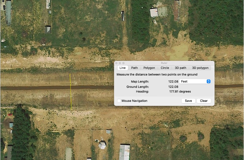
In the example above, the 3-mile long ditch on the right has expanded almost 80 feet between 2017 and 2023.
Google Earth Pro shows ditch was 122 feet wide in 2017 shortly after construction.By 2023, erosion had widened same ditch to 198 feet.
All that erosion contributed to the formation of a 4,000-foot sand bar where the San Jacinto East Fork meets Lake Houston. Sediment drops out of suspension where water slows down as it meets a standing body of water.
East Fork Mouth Bar in 2019
We frequently see similar runoff from sand mines and developments in Montgomery County.
Confluence of Spring Creek and San Jacinto West Fork. Spring forms the dividing line between Harris and Montgomery Counties. Photo taken 11/11/23.
Such sedimentation reduces conveyance at unnatural (accelerated) rates and creates blockages in the river.
West Fork mouth bar in headwaters of Lake Houston. Army Corps found conveyance of West Fork reduced by 90% because of this and similar blockages upstream.
Sedimentation is a maintenance issue everywhere at every scale. The montage below shows representative images of roadside ditches in Harris County that have filled in. During storms, blocked storm pipes trap water in neighborhoods.
Roadside ditches blocked by sediment keep water from reaching bayous and back water up into homes.
Acceptable foundation types in flood- hazard areas
Building in floodways including width, depth, bracing and other requirements for piers
Where fill can and cannot be used
Detention pond requirements
Wind resistance
Elevation above street level
After Harvey, Harris County Engineering compared damage found in subdivisions built before and after the new standards.
Subdivisions built with the updated standards experienced one twentieth the amount of damage.
However, “grandfathering” of new developments under older regulations often contributes to insufficient mitigation that can affect property owners downstream. For instance, one recently completed 77-acre RV park in the Kingwood area has a detention basin that holds half the stormwater required by new regulations, even though it was built after they went into effect.
Building, Buying Too Close to Threats
The goal of many engineering studies is to build “safely” near water. What do you have to do to protect a family from a hundred-year flood?
These scientific-looking studies are incomprehensible to most people. Yet the engineering seals on them create a sense of security. So does the availability of nationally subsidized flood insurance.
Given those reassurances and given that some people will pay a premium to live near water despite the threats, some developers push the envelope into areas prone to flooding. That’s how we get high-density development in floodplains.
Apartments crowd Brays Bayou at Kirby. HCFCD and its partners have spent more than a half-billion dollars since 2000 to mitigate flooding along Brays.
Similarly, some developers pave over wetlands and ponds that are nature’s stormwater detention systems.
Site of Madera development in Montgomery County at FM1314 (north/south) and SH242 (east/west).Same intersection but looking SW. Looking at what used to be wetlands on the NE side of SH242/FM1314.
Loss of these wetlands reduces floodwater storage. Before development, this area was a 10-year flood zone.
It’s sometimes possible to fix flood threats after the fact. But building on properties like you see here leaves little room for mitigation.
More to Follow
Come back tomorrow when I’ll elaborate on three more root causes of flood damage.
Upstream changes that undermine downstream assumptions
Difficulty of adapting to those changes downstream
Historical unwillingness to fund flood mitigation at meaningful levels
Posted by Bob Rehak on 11/19/23
2273 Days since Hurricane Harvey
The thoughts expressed in this post represent opinions on matters of public concern and safety. They are protected by the First Amendment of the US Constitution and the Anti-SLAPP Statute of the Great State of Texas.
https://i0.wp.com/reduceflooding.com/wp-content/uploads/2023/11/image-4.jpeg?fit=1226%2C610&ssl=16101226adminadmin2023-11-19 13:14:492023-11-19 14:44:06Why So Much Flood Damage?
11/18/23 – It was a busy week for the new Northpark South development. A Drainage Impact Analysis submitted to Montgomery County for the development at the west end of Northpark Drive shows that the developer intends to drain its property through adjacent sand mines owned by other entities. The analysis does not address potential sedimentation issues.
The developer also applied for several variances from the Houston Planning Commission.
Meanwhile Century Land Holdings of Texas, LLC continued clearing land at the west end of Northpark Drive that borders the sand pits along the West Fork San Jacinto River. In the last week, contractors have cleared approximately one third to one half of the 54.4 acre development.
Drainage from 107.2 acres outside (upstream from) the development flows through the development on its way to the West Fork.
The remaining 43.2 acres will contain 236 homes on narrow lots for an average of 0.18 acres/home (1/6th acre) with impervious cover of 66%.
Proposed layout in drainage analysis.
Drainage from the development and areas upstream will be routed into an on-site 11.2 detention basin (above) and, from there, into sand pits and the West Fork (below).
Outfall path from Northpark South to sand pits, channel and river.
The drainage analysis claims the outfall from the proposed detention basin will not increase flow to the sand pits.
The analysis by RG Miller also indicates that the on-site basin will provide a storage rate of approximately 1.26 acre-feet per acre. That exceeds the minimum of .55 acre-feet per acre recommended by Harris County Flood Control District for sites this size draining into Harris County.
RG Miller claims that the water surface elevations in the sand pits will decrease during both 25-year and 100-year storm events.
The engineering firm also claims that the proposed development lies outside the 100-year floodplain of the West Fork. However, that claim is based on old data.
100-year floodplain, shown in aqua. Note 2014, pre-Harvey date.
New flood maps, expected to be released next year, will likely show the floodway and floodplains expanding by 50- to 100%, according to preliminary guidance from HCFCD and FEMA.
However, RG Miller makes no mention of the shifting floodplains. Nor do its engineers mention any wetlands on the property which the US government clearly shows.
Large green area on right was among first to be cleared.
The engineering firm concludes that their design will have “no adverse impact” on downstream properties. Nor will it “unreasonably”:
“Impede the natural flow of surface waters from higher adjacent properties”
“Alter the natural flow of surface waters so as to discharge them upon adjacent properties at a more rapid rate or in a different location…”
One hydrologist I interviewed about this plan said, “Well, this isn’t how I would do it. He is draining directly to the sand pit and showing that he isn’t increasing flows going to the sand pit. Nowhere in the report did he document that he had permission from the sand pit owner to drain to the sand pit. Also, he didn’t have any field survey to back up how he knew the topography and details on the hydraulic connections between the sand pits and the river. So I don’t know how he can be certain of his results.”
The drainage analysis did not address what effect the proposed routing would have on sedimentation. The outfall to the drainage ditch is already severely restricted by sediment accumulations.
Proposed outfall. 11/17/23
Variance Requests
A request for variances obtained from the Houston Planning Commission shows a different outline for the property. It omits the areas designated as commercial at the entry.
Note difference between this diagram and one above in lower right corner by Northpark.
The MoCo Appraisal District (MCAD) shows that Hanover Estates owns the parcels that bracket the entry. MCAD also shows that Hanover and another company called Maryfield LTD jointly own the sandpits. The drainage analysis does not address the ownership issues or permissions.
Requests for Variances from Houston Planning Commission
This property lies within the City of Houston’s extra territorial jurisdiction. The developer requested three variances from the Houston Planning Commission:
To allow lots less than 5000 square feet.
To exceed intersection spacing by not providing a southern stub street (outlet).
To exceed intersection spacing by not providing an east/west street
The planning commission has not yet responded to an information request about whether it granted the variances. Meanwhile, clearing continues.
One Third to One Half of Site Now Cleared
In the last week, contractors have taken down an estimated one half to one third of the trees on the site. See below.
Looking west across Northpark South toward West Fork San Jacintoon11/17/23. Intersection of Northpark Drive in foreground and Sorters-McClellan Road running diagonally through frame.
Friday morning, 11/17/23, four tree gobblers were hard at work.
At this rate, the entire site could be cleared by early December.
A Closing Thought
The goal of most drainage studies is to figure out how to develop property safely. If all of the studies were always correct, we would never flood. But we do. Why?
And why is property that was too dangerous to develop before Harvey now safe after Harvey … when we now realize how much greater the risk is?
More on that in my next post.
Posted by Bob Rehak on 11/18/23
2272 Days since Hurricane Harvey
The thoughts expressed in this post represent opinions on matters of public concern and safety. They are protected by the First Amendment of the US Constitution and the Anti-SLAPP Statute of the Great State of Texas.
https://i0.wp.com/reduceflooding.com/wp-content/uploads/2023/11/20231118-Screenshot-2023-11-18-at-6.37.37%E2%80%AFAM.jpg?fit=1100%2C512&ssl=15121100adminadmin2023-11-18 08:08:502023-11-18 10:32:42Northpark South Will Drain Through Sand Mines
The Northpark Drive Expansion Project struck oil this week. But this was no Jed-Clampett moment. Oil in the context of a construction project is not good.
Workers discovered what appears to be oil dumped some years ago on the site of what will become the north pond at the 59 entrance to Kingwood.
Ralph De Leon, project manager for the Lake Houston Redevelopment Authority/TIRZ, said that contractors are currently trying to discover the extent of the spill to avoid future contamination on the site. Although the photos below certainly look like excavation, the work is definitely not part of the pond-excavation project, according to De Leon.
Looking south at oil spill areaReverse angle shows trucks entering and leavingThe nasty surpriseClose up of contamination
De Leon also said the budget contained a line item for contingencies such as this. It should not affect the overall cost of the project.
West Sidewalks Complete
De Leon also said contractors have completed the sidewalks west of 59 that connect the main part of the project to the Kingwood Place West and Kingwood College.
This morning, the last cement pour was drying and contractors were removing forms from areas completed earlier.
Workers are still cleaning up, but the job is essentially done. Looking west toward HEB from over 59.Reverse angle. Looking easttoward 59 at top of frame.
Dr. Katherine Persson, retired head of Kingwood College, requested the sidewalk extension to fill in a critical gap for her students who rode their bicycles to school.
Other Highlights
Extension of the drain pipe to Ditch One behind Public Storage is nearly complete. However, contractors still need to install a concrete headwall around the pipe to prevent future erosion.
Contractors are preparing an estimate to install the city-approved, water-main detour under Northpark to the new Parkwood Baptist Church. The original water main was too high and interfered with the box culverts being installed in the median.
Centerpoint has nearly completed relocating its utilities that interfered with the box-culvert installation. As soon as CenterPoint completes that work, installation of the box culverts will resume.
The pole-mounted traffic signal at Northpark and Russell-Palmer must come out before contractors can install the box culverts under that intersection. A wire-mounted, temporary signal will replace the pole-mounted system. The wire will stretch across the road. As construction advances, that will enable the signals to be moved left or right as lanes change.