In the wake of Hurricane Harvey, many officials complained bitterly that money from the State’s “rainy day” fund couldn’t be used for flood mitigation projects. Former Harris County Judge Ed Emmett often said, “If Harvey wasn’t a rainy day, I don’t know what is!”
Creighton Introduces Bill That Could Speed Flood Mitigation
Responding to a need that many recognized, in February, Texas State Senator Brandon Creighton introduced SB 695. On March 1, it went to the Senate Water and Rural Affairs Committee. It relates to state policies and programs that affect the funding of flood planning, mitigation, and infrastructure projects.
SB 695 went to the Senate Water and Rural Affairs Committee last Friday.
Creighton’s bill would appropriate $3 billion from the state’s economic stabilization fund to a dedicated flood infrastructure fund. The purpose: to make low- or no-interest loans to cities, counties, and water authorities for:
(1) planning for flood protection;
(2) preparing applications for obtaining regulatory approvals at the local, state, or federal level;
(3) activities associated with administrative or legal proceedings by regulatory agencies; and
(4) preparing engineering plans or specifications to provide structural or nonstructural flood mitigation or drainage.
$3 Billion In Ready Cash Could Streamline Process
The main benefit: the bill provides ready cash in emergencies, such as Harvey, to jumpstart mitigation projects.
Because of the complicated way that grant funding now works, political entities must often apply for grants to raise the money for a local match to then apply for a larger grant. The result: lengthy delays.
Example: it took 18 months to obtain $2 million for a San Jacinto River Basin Study that will take another 12-18 months to execute. By the time people start acting on the findings, it could be another year or two.
This important bill deserves everyone’s support, Democrats and Republicans alike. It could be one of the most important pieces of legislation taken up this year. My understanding is that former Harris County Judge Emmett, Harris County Flood Control and Houston Stronger all backed the idea.
Posted by Bob Rehak on 3/4/2019
552 Days after Hurricane Harvey
https://i0.wp.com/reduceflooding.com/wp-content/uploads/2019/02/capitole_1024.jpg?fit=1024%2C768&ssl=17681024adminadmin2019-03-03 19:13:162019-03-03 19:38:39Senator Creighton Introduces Bill that Could Speed Up Flood Planning, Mitigation
A knowledgeable reader with an engineering background looked at this morning’s post about flood-bond projects approved to date. He made an observation that, frankly, fleetingly occurred to me also. He said that the majority of the projects seem to be upstream rather than down. He also questioned the wisdom of that. Should we not start downstream and work back up? That way, he said, you don’t accelerate water rushing downstream to get caught behind a mouth bar. His fear: it could make flooding worse in downstream communities.
Official Flood Control Response
HCFCD logo
So I called Matt Zeve, the Deputy Executive Director at Harris County Flood Control. I related the reader’s concern and asked him why the commissioners approved the projects that they have.
It comes down to three things. said Zeve.
First and foremost, Flood Control didn’t want to stop any projects that were in the works and about to kick off when the bond was passed. Flood control was already pretty far down the road with most of the projects that have been approved.
Second, they have responded to extreme community pressure in some cases.
Third, the availability of partner funding accelerated some projects, too. For instance, two weeks ago, the County received commitments from FEMA, City of Houston, Montgomery County and the SJRA for the San Jacinto River Basin Study. The county quickly approved its share also. The intent: to honor commitments from partners that extend County funding.
Those all sounded like valid reasons. Zeve also acknowledged that in an orderly world, he would have preferred moving from downstream to upstream. Perhaps that may happen as the priority order of bond projects becomes finalized.
But in reality, other factors like partner funding may alter the order. I have to believe that if FEMA came up with $50 million to remove the mouth bar, the dredgers would attack it tomorrow.
Zeve now estimates that the new list should be posted by end-of-day Monday. Check back. We’ll see how Rev 2.0 changes the order now that the low-to-moderate income (LMI) ranking has been removed.
Posted by Bob Rehak on March 2, 2019
550 Days since Hurricane Harvey
https://i0.wp.com/reduceflooding.com/wp-content/uploads/2019/03/logo.png?fit=110%2C130&ssl=1130110adminadmin2019-03-02 17:43:442019-03-02 17:57:36Why Most Flood-Bond Projects Approved to Date Appear to Favor Upstream Locations
Six months have passed since the passage of the Harris County Flood Bond last August. Several projects have been approved so far that could benefit the San Jacinto watershed.
Tributary Map Showing Where the Water Fell During Harvey
This watershed map shows the volume of water carried by each tributary during Harvey.
Map of upper San Jacinto watershed basin shows streamflows during Harvey in cubic feet per second (CFS). Source: San Jacinto River Authority.
Flood Bond Projects Approved to Date
Projects approved so far:
Z-10 will resurvey and remap floodplains country wide. Contractors will factor in new rainfall data and use advanced modeling technologies to provide more accurate information on flooding risks.
CI-012 provides major maintenance for Cypress Creek, an upstream tributary.
CI-035 will update the 2003 Texas Water Development Board Regional Drainage Plan for Major Tributaries of Cypress Creek.
F-20 approved right-of-way acquisition and floodplain preservation, also for Cypress Creek.
Project C-58, final design of Drainage Improvements Along HCFCD Unit F101-06-00 (San Jacinto and Galveston Bay).
C-17, the San Jacinto River Watershed Study in cooperation with the SJRA, Montgomery County, and the City of Houston.
F-14, drainage improvements near Kingwood
F-110, drainage improvements in the Huffman area that drain to the San Jacinto, Luce, and Cedar Bayou watersheds.
F-19, right-of-way acquisition and floodplain preservation along Spring Creek.
Voluntary Home Buyout programs are also in progress county wide and will affect many Forest Cove residents south of Hamblen Road as well as in Humble.
To see the full list of projects approved for the bond fund, click here. They are arranged in alphabetical order by watershed. San Jacinto River Projects start on page 9. However, don’t overlook related tributary projects, such as additional upstream detention on Spring and Cypress Creeks.
Posted by Bob Rehak on March 2, 2019
550 Days since Hurricane Harvey
https://i0.wp.com/reduceflooding.com/wp-content/uploads/2019/03/Hurricane-Harvey-Peak-Inflows-1500-px.jpg?fit=1500%2C996&ssl=19961500adminadmin2019-03-02 08:55:502019-03-03 16:08:52Flood Bond Projects Approved to Date by Harris County Commissioners Court
A reminder. If you want to protest the high-rise development planned for Kingwood, today is the last day to email the Army Corps of Engineers and the Texas Commission on Environmental Quality. The deadline: midnight tonight.
The proposed high-rise development would wrap around the Barrington and border the soccer fields at River Grove Park. It includes 5000 condos, and multiple high rises from 25 to 50 stories tall. Developers, who are being sued for fraud by investors, are attempting to finance the project with EB-5 visas for foreigners.
High Rises in Area Apparently Deed-Restricted to Single-Family Residential
The development would take place in an area apparently deed restricted to single-family residential. Developers have refused to meet with the public to answer questions concerning the development or how they plan to get around the deed restrictions.
Sample letters that people and groups have written already.
Causes for Concern
Many of reasons exist to protest this development. Besides the 8,800 cars it would add to Kingwood Drive, the lack of evacuation routes, apparent deed restriction violations, impacts on wildlife including bald eagles, loss of wetlands and streams, flooding, adequacy of the market survey, safety issues (building high rises so near a floodway), water pollution from a giant marina operation, school over-crowding, and the experience of the developers.
How and Where to Protest
The Corps states explicitly that if they don’t hear from you, they assume you have no objections.
So please take ten minutes to email your objections to:
Feel free to copy from the letters of others. Make sure you include the project number in the subject line of your email: SWG-2016-00384
Posted by Bob Rehak on March 1, 2019
549 Days since Hurricane Harvey
The thoughts in this post represent my opinions on matters of public policy. They are protected by the First Amendment of the US Constitution and the Anti-SLAPP statutes of the great State of Texas.
https://i0.wp.com/reduceflooding.com/wp-content/uploads/2019/01/Woodland-hills-map.png?fit=1061%2C1024&ssl=110241061adminadmin2019-03-01 10:36:012019-03-01 11:08:21Last Day to Protest High-Rise Development in Kingwood
Harris County Flood Control has developed a new way to prioritize bond projects after a trial ballon turned into a lead balloon. Initially the county ranked projects based, in part, on readily available income statistics to achieve its equity goal in ranking projects.
However, giving low-to-moderate-income (LMI) neighborhoods higher priority than affluent neighborhoods facing greater flood threats hardly seemed fair. It sparked a tsunami of criticism.
When flood control shared its initial formula for ranking projects with small groups of community leaders, they pushed back immediately. They argued that the worst flooding problems should be tackled first. As a result, the county developed an alternative formula that didn’t rely on income.
Homes in Barrington in 500-year flood plain during Harvey. Photo courtesy of Julie Yandell. She was forced to flee with her husband and 81-year-old neighbor when waters rose without warning.
Factors in Initial Proposal
Version 1.0 of the prioritization attempted to rank-order projects based on seven factors, each given different weights.
Existing Conditions – Drainage Level of Service (How Bad Things Currently Are) – 20%
Equity (LMI) – 20%
Flood Risk Reduction (Looking only at # of Structures, not their Value) – 20%
Project Efficiency (Cost of project/# of Structures Benefitted) – 15%
Problems with Version 1.0
Scoring projects using these criteria pushed Kingwood – one of the hardest hit areas in the city – farther down the list in most cases. Therefore the leaders of the Lake Houston Area Grass Roots Flood Prevention Initiative sent a letter to the new County Judge listing these concerns.
Failure to appropriately recognize benefits from multi-million dollar partnership matching grants
Failure to capture full flooding impacts and full project benefits by not considering commercial property, schools, hospitals, and senior-care facilities
Not recognizing benefits to LMI areas received from projects executed in non-LMI areas
Not considering Costs/benefits of pre-Harvey Capital Improvement Projects
Lack of inclusion of URGENT NEED criteria in the matrix
Based on initial feedback, Harris County Flood Control has already posted version 2.0 of the ranking formula. The goal: to provide a defensible methodology for determining when one project will start versus another.
Differences in Version 2.0
Version 2.0 of the formula:
Takes LMI consideration out
Adds an eighth criteria, “Do we have a funding partner for a project? Yes/No?”
Changes weighting to give more urgency to parts of town that historically have had a lower level of service.
Looks at some old criteria in new ways.
Here are the new weights and criteria:
Flood Risk Reduction – 25%
Existing Conditions Drainage Level of Service – 20%
Lack of Service – 15%
Project Efficiency Weighting Factor – 15%
Partnership Funding – 10%
Long Term Maintenance Costs – 5%
Minimizes Environmental Impacts – 5%
Potential for Multiple Benefits – 5%
“You Have to Start Somewhere”
“You have to start somewhere,” said Zeve. “We’re trying to be as transparent as possible so people understand the order in which we attack projects.”
The revised project-priority list has not yet been posted. That should happen tonight or this weekend according to Zeve. They need to score and calculate many factors for hundreds of projects. I can’t wait to see the outcome. More news to follow tomorrow.
How to Be Heard
If you would like to participate in this process, or send written comments, please email Gabe Baker at gabe.baker@cjo.hctx.net.
Posted by Bob Rehak on 3/1/2019
549 Days since Hurricane Harvey
https://i0.wp.com/reduceflooding.com/wp-content/uploads/2019/02/IMG_0048-1-e1646428414628.jpg?fit=900%2C1200&ssl=11200900adminadmin2019-03-01 07:34:272019-03-01 09:41:17County Suggesting New Way to Prioritize Flood-Bond Projects
At its February 28th meeting, the San Jacinto River Authority voted to maintain its lake-lowering policy for another year. The policy calls for lowering Lake Conroe one foot below normal pool level (from 201 feet to 200) during the wettest months in Spring and two feet during the peak of hurricane season.
Extra Safety from Flooding
Until other mitigation measures can be put in place, the plan gives downstream residents an extra measure of safety from massive releases like those experienced during Hurricane Harvey. Those include dredging and additional flood gates for Lake Houston.
This is good news for the Lake Houston Area where Harvey made approximately 11,000 people homeless overnight.
Complaints from Lake Conroe Association in January Meeting
The Lake Conroe Association set the stage for conflict last month. The Association testified that last year’s lowering had a negative impact on business and home values in the area. They also maintained that the Board had acted unilaterally – without consultation – and that the project was only supposed to last through the end of dredging.
Having been at last year’s meeting where the proposal was discussed, I would disagree with these statements. The board considered dredging and gates for Lake Houston. The board also acted on the report of a consultant hired to review the proposal.
Mark Micheletti, a SJRA board member, said the board had received no complaints from businesses on the lake and that a check with realtors found no negative effect on home prices.
Reportedly, the Lake Conroe Association had also collected signatures on a petition asking for the policy to be reversed. At today’s meeting, the room was crowded with spectators, but I did not see the Association’s president, Mike Bleier. The association presented no petition.
The cataclysmic impacts on Lake Conroe’s economy did not materialize. Because of evaporation, the lowering really only amounted a little more than a foot in the fall.
Speaking for Kingwood
During the public comment section of the meeting, three Kingwood residents, Bill Fowler, Amy Slaughter and I, spoke FOR continuing to lower the lake. So did one Lake Conroe resident who flooded during Harvey.
I pointed out the fact that dredging was NOT yet complete and that the river still had an exaggerated flooding response to moderate rainfalls because of sediment dams. Fowler talked about normal evaporation levels in the lake and how the lowering was not as great as the targets would imply. Slaughter mentioned the impact of flooding on her family and recent Supreme Court rulings on inverse condemnation.
The Lake Conroe resident said he wished the Lake were lowered year round. He flooded during Harvey and thought that the lower levels would actually help Lake Conroe home values.
“But what if there’s a drought?”
When it came time to speak AGAINST the lowering, one man spoke up. He used water conservation as his main argument and posed the specter of drought.
When the board began debating the measure, Jace Houston, SJRA’s general manager, pointed out that many people misunderstood the measure. He said that the SJRA was not going to lower the lake beyond the 1- and 2-foot levels in the policy. If the lake was already down a foot due to evaporation, for instance, the SJRA would release no additional water.
Progress of the current West Fork dredging and Lake Houston Gates projects
Rainfall averages and historical lake levels by month
How the lowering and subsequent raising of the lake worked last fall
Staff recommendations
Graph presented by Chuck Gilman showed how gradual lowering and natural refilling of Lake Conroe worked last year. Gilman also showed a slide discussing the status of additional gates for Lake Houston.
To see all the slides in the original high-resolution PDF format, click here.
Brenda Cooper, a new SJRA Board Member, then mentioned that some Lake Conroe residents had approached her to voice their disapproval of the project.
Motion Passes Unanimously
Board President Lloyd Tisdale finally called for a voice vote. “All members present voted FOR the lowering,” said Mark Micheletti, one of the Lake Houston Area’s two members on the SJRA board. “The vote could not have gone better from the Lake Houston area’s perspective.”
The SJRA will continue to lower Lake Conroe seasonally. The measure will come up for discussion again next February.
Community Reaction
Bill Fowler, Vice Chair of the Lake Houston Area Grass Roots Flood Prevention Initiation, said, “I was impressed by the Board’s firm grasp of the importance of lowering Lake Conroe on a seasonal basis for downstream residents. Their willingness to help until permanent solutions can be implemented impressed me.”
Kaaren Cambio, another SJRA board director from the Lake Houston area, said, “I’m happy that the board is balancing the needs of both upstream and downstream communities.
Amy Slaughter, the Kingwood lawyer whose home flooded badly, said, “They did the right thing.”
Posted by Bob Rehak on February 28, 2019
548 Days After Hurricane Harvey
https://i0.wp.com/reduceflooding.com/wp-content/uploads/2019/02/2019-Temporary-Seasonal-Lake-Lowering-002_Page_08.jpg?fit=1500%2C871&ssl=18711500adminadmin2019-02-28 18:57:542020-01-17 10:01:45SJRA Board Votes to Maintain Lake-Lowering Policy for Another Year
Eighteen months ago, approximately 11,000 Kingwood, Humble and Atascocita residents went to bed thinking they had escaped the worst of Harvey’s wrath. Hours later, they woke up to find water seeping through their windows, doors and walls in the dark of night. Without any warning. Thanks in part to the release of 80,000 cfs from the Lake Conroe dam.
However, rumor has it that one or more members of the board want to present a petition by Lake Conroe boaters to NOT lower the lake level this year. To everyone who signed that petition, I dedicate this photo essay.
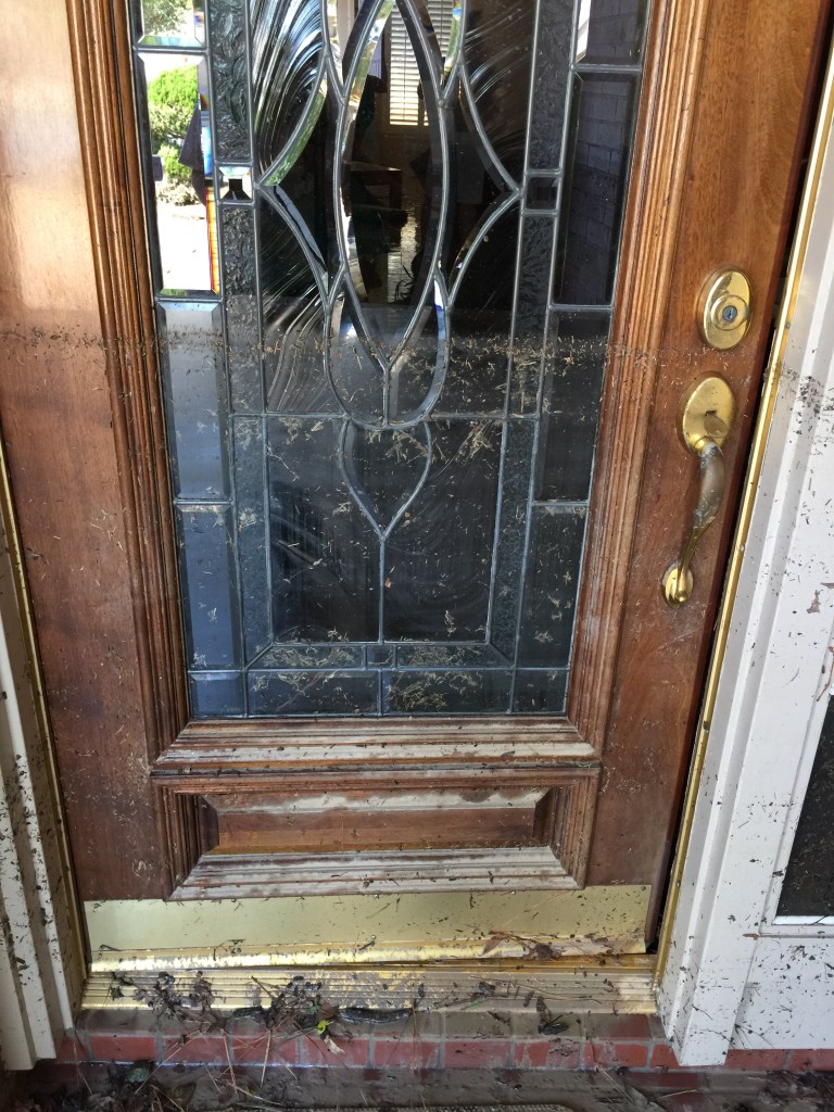
Water Sculptures by Julie Yandell. Taken during evacuation. Yard decorations take on an ominous feeling in the flood.The flood cut off Woodland Hills Drive, a major escape route for people in Kingwood Lakes, the Barrington and Kings Cove.Trash Day in the Barrington after Harvey. Photo by Joy Dominique.Siding from home washed downstream during Harvey. Photo by Dan Monks.Water skiing, anyone? Photo by Sidney Nice of Atascocita Point after Harvey.Sidney Nice’s kitchen after Harvey flooded the house to a depth of 63″.Sidney Nice’s house in Atascocita Point during Harvey.Rebecca Johansen’s front door shows how deep flood waters got in her home … 40 inches.Townhomes on Marina Drive in Forest Cove. Concrete and steel were less effective at preventing erosion than blades of grass.Elderly residents of Kingwood Village Estates trying to escape as Harvey’s floodwaters rose. Twelve residents later died: six as a result of injuries sustained during evacuation and another rise as a result of stress from losing their homes.Marilyn Davenport: Home Damaged During HarveyFrom Ann Crane: “We had over 70 people helping to clear and clean our house. The Kingwood community coming together.”Jennifer Manning: “What 18 inches of floodwater can do to your home.” From Walden on Lake Houston.Jennifer Manning: “We lived in Kingwood from 1992-2012 before buying a house in Walden that was ‘built above the ’94 flood.’ We finished our rehab in June.” Ten months!The Kelsey Seybold Clinic has also been vacant since Harvey. 44% of all businesses in the Lake Houston Area Chamber were damaged. Some will never return.Picture by June Ledet of Harvey flooding in Kingwood. Corner of Kingwood Drive and Forest Garden. Flooding here cut off escape routes for thousands more.
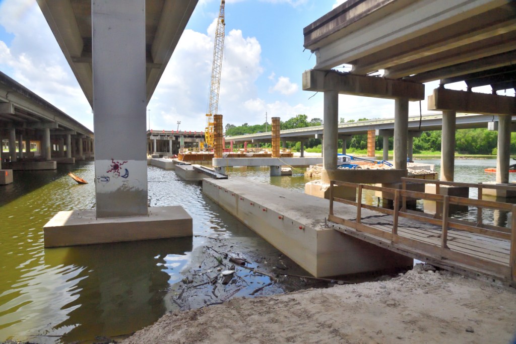
Classroom building at Lone Star College/Kingwood flooded during Harvey after SJRA release. Six of nine buildings flooded causing more than $60 million in damage. The College just fully reopened this month.
Milan Saunders home in Kingwood LakesThat’s all, folks! Harvey flipped the baby grand piano and broke to legs off the heirloom.Repairs to IH-69 took about 10 months and $20 million, disrupting all traffic into and out of the City for hours each day.The mother of all walk in closets…Amy Slaughter’s garage.
Home of a single mother who had just lost her job.
When sewage treatment plants flooded, toilets began flowing in reverse.
So please, Lake Conroe boaters. Let’s keep this in perspective. We understand your inconvenience. Please try to understand ours. Help us recover our lives.
To see more examples of how Harvey affected the lives of Lake Houston Area residents, please see the Submissions Page of this web site. It contains images submitted by residents affected by Harvey. If you have images you would like to share, please send them in via the Submissions Page.
Posted by Bob Rehak on February 28, 2019
548 Days since Hurricane Harvey
https://i0.wp.com/reduceflooding.com/wp-content/uploads/2019/02/IMG_0082.jpg?fit=1500%2C1125&ssl=111251500adminadmin2019-02-27 21:53:092020-01-17 10:14:23The Night that 11,000 Lake Houston Area People Became Homeless
With barely a spoken word, this video makes an eloquent case for lowering Lake Conroe again this year. It also makes a powerful argument for denying the permit to build 5000 condos and high rises in the surrounding wetlands.
Evacuation from the Barrington during Harvey. Video courtesy of Kenneth and Colleen Ulrich. They moved to Kingwood from New Orleans after Katrina.
Surprise Evacuation
Kenneth Ulrich Jr. shot this video as he and his wife Colleen were forced to evacuate without warning from the Barrington during Harvey.
They share this video on the eve of a key San Jacinto River Authority board meeting. Tomorrow, the board will take up the question of whether to seasonally lower Lake Conroe again this year. The lowering would help provide a margin of safety against flooding like this until other flood mitigation measures can be put in place.
Lake Conroe boaters have complained about the inconvenience of the lower lake levels. The video shows what boating in Kingwood looked like 18 months ago as Harvey’s floodwaters rose.
Many residents escaped with little more than the clothes they wore.
Imagine Evacuating 15,000 People Like This
The video makes another powerful argument. Against the high-rise development proposed for Kingwood. Developers hope to build it around the Barrington which you see here. They want to build 5,000 condos immediately to the north and a string of high rises, including a 50 story hotel, immediately to the south. Kingwood has an average household population density of 2.71. That means this development could add 15,000 people to the area.
Every one of the 283 homes in the Barrington flooded. Imagine trying to evacuate another 15,000 people by boat during the next Harvey.
The developers have planned only one way in and out of this project – Woodland Hills Drive – which will be under water when the next big flood hits.
Clearly, they did not consider evacuation when they planned this development.
How to Register Your Concerns
If you have concerns about the high-rise project, email the US Army Corps of Engineers at: swg_public_notice@usace.army.mil . Make sure you put the project number in the title of the email: SWG-2016-00384 .
To voice your concerns to the SJRA board, attend the board meeting Thursday, Feb. 28 at:
1577 Dam Site Road Conroe, Texas 77304 936.588.3111
Speakers are limited to three minutes each. Business attire is recommended. To reserve time to speak you must sign in by 7:45. The meeting will be in the tall building.
Allow an hour and fifteen minutes to an hour and a half to get there in rush hour traffic from the Humble/Kingwood area.
As always, these are my opinions on matters of public policy. They are protected by the First Amendment of the U.S. Constitution and the Anti-SLAPP statute of the Great State of Texas.
Posted by Bob Rehak on 2/27/2019
547 Days after Hurricane Harvey
https://i0.wp.com/reduceflooding.com/wp-content/uploads/2019/02/Barrington-Video-Keyframe.jpg?fit=1500%2C733&ssl=17331500adminadmin2019-02-27 11:49:282020-01-17 10:02:26Video of Barrington Evacuation During Harvey Makes Case for Lowering Lake Conroe, Nixing High-Rise Development
At its Thursday board meeting, the SJRA will reconsider whether to seasonally lower Lake Conroe again this year. Last year, the board lowered the lake as a way to provide an additional buffer against flooding until flood mitigation projects could be put in place. As part of the motion it approved last year, the board said it would revisit the decision each year. That time is now.
Even though Lake Houston area dredging continues and additional gates for the Lake Houston Dam have not yet been funded, re-approval of the lowering this year is far from automatic. Rumor has it that the Lake Conroe Association may present a petition urging the board to keep the lake at its usual height.
Details of Original Plan
What exactly was the temporary, seasonal lake lowering proposal? SJRA General Manager Jace Houston spelled out the details for the public in Dockline Magazine last year. I pulled these figures from there.As a point of reference, the normal pool level of Lake Conroe is 201’ msl (mean feet above sea level).
During the Spring season – April 1 through May 31 – the SJRA voted to start lowering the lake gradually on April 1 until it reached a level of 200 msl, i.e., one foot below normal. This is the rainiest part of Spring.
Then starting on June 1, the SJRA would begin to capture flows to restore normal lake elevation for June and July.
For the Fall season – August 1 through September 30 – which includes the peak of hurricane season, the SJRA would again reduce the lake gradually. Their target: 200 msl by August 15. That’s when most local schools resume and the summer vacation season starts to tape off.
After August 15, SJRA would continue gradually lowering the level of Lake Conroe until it reached 199 feet msl or two feet below normal pool by August 31.
Starting October 1, SJRA would again begin to capture flows to restore normal lake elevation.
If the lake level has already dropped to the target elevation just due to evaporation, no additional releases would be made.
If a storm enters the forecast while seasonal releases are being made to lower the lake level, such releases would be stopped and the river allowed to drain out until rainfall is out of the forecast.
Purpose for Season Lowering
Jace Houston cited three reasons for seasonal lowering as opposed to pre-releasing water immediately before storms.
Release of water from Lake Conroe prior to a storm would put flows into the San Jacinto River and Lake Houston potentially exacerbating flooding.
Staff from the City of Houston, the Coastal Water Authority, and the Harris County Flood Control District have expressed their desire to not pre-fill the river and Lake Houston prior to a storm with water released from Lake Conroe.
Lake Conroe is located in the upper basin where it makes sense to retain flood waters to the extent possible.
Until dredging is complete, we still need the buffer that lowering Lake Conroe provides.
Speak at Board Meeting
Residents have an opportunity to speak out for and against the seasonal lowering this Thursday morning, Feb. 28, 2019. Speakers are limited to three minutes each. Business attire is recommended. To reserve time to speak you must sign in by 7:45. The meeting will be in the tall building at:
1577 Dam Site Road Conroe, Texas 77304 936.588.3111
Allow an hour and fifteen minutes to an hour and a half to get there in rush hour traffic.
Hope to see lots of Humble and Kingwood people there. This is very important until we get mitigation measures in place.
If You Can’t Come, But Still Want to Help
Consider sending ReduceFlooding.com some of your most dramatic shots from the flood. See the Submissions page. We need to show the SJRA board how dramatic the flooding really was here. There are new faces on the board this year.
Posted by Bob Rehak on February 26, 2019
546 Days after Hurricane Harvey
https://i0.wp.com/reduceflooding.com/wp-content/uploads/2019/02/SJRA-Logo-2016-250x250.png?fit=250%2C250&ssl=1250250adminadmin2019-02-26 19:30:022020-01-17 10:02:54SJRA to Reconsider Lowering of Lake Conroe This Thursday Morning
Odum previously served as the President of Shell Oil Company. He volunteered to work for the City as the Mayor’s “Flood Czar” for 15 months on a pro bono basis.
Stephen Costello, the City of Houston’s Chief Recovery Officer in charge of Harvey efforts and the Mayor’s Flood Czar.
So I emailed Costello and heard back this morning. He replied, “I am the Chief Recovery Officer focused on Harvey recovery. Still doing the flood czar stuff as well.”
Evidently, the title of one of Costello’s jobs changed and he’s still picking up where Odum left off. Hopefully, Aho’s appointment will allow Costello more time to focus on flood mitigation.
Posted by Bob Rehak on February 26, 2019
546 Days after Hurricane Harvey
https://i0.wp.com/reduceflooding.com/wp-content/uploads/2019/02/Costelloo-e1551210507211.jpg?fit=907%2C1203&ssl=11203907adminadmin2019-02-26 13:38:022019-02-26 13:55:57Despite new Chief Resiliency Officer, Costello Still Heading Up Flood Recovery Efforts