While much of the press after Harvey focused on the wisdom of development in floodways and floodplains, the plight of homes and businesses much further from the San Jacinto was largely overlooked. Amy Slaughter and Jennifer Trimble bought homes more than a mile from the river, thinking they beyond the reach of floods. They weren’t. Homes near mine, almost two miles from the river, also flooded.
Page 13 of the Harris County Flood Control District’s final report on Harvey states, “Of the 154,170 homes flooded, 48,850 were within the 1% (100-yr) floodplain, 34,970 within the .2% (500-yr) floodplain, and 70,370 were outside of the 1% (100-yr) and .2% (500-yr) floodplains.” In other words, 46% were not in a marked flood plain. Which helps to explain the staggering number of uninsured homeowners.
Sixty-four percent of all the homes flooded did not have flood insurance.
Carolanne Norris took this shot while sitting on her stairs, watching her home fill with water.
Looking toward Kingwood Drive from Woods Estates and Twin Grove. Carolanne Norris took this from an upstairs window as the floodwaters rose during Harvey. Note the water level near the stop sign one block north of Kingwood Drive.
Carolanne Norris took this shot as she and her family hiked to safety. Shot is looking back down Woods Estates from a hill near Valley Manor . The Kings Forest Pool is on right. This is more than 1.75 miles from the river as the crow flies.
“Bath anyone?” Photo of Carolanne Norris’ tub after Harvey’s floodwaters went down and she could get back in her home.
“The water was strong enough to pick up my island with a granite counter (bottom) and slam it into my double ovens.” Photo by Carolanne Norris.
Carolanne Norris’ home took on 44 inches of water. Wakes from all the rescue boats had water lapping at her first-floor eaves.
“Nice reminder that you sometimes have to laugh when all you want to do is cry.” Photo by Carolanne Norris.
Photos by Karen Favero
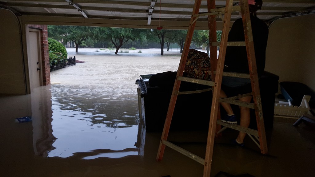
The Cleanup After Harvey Begins. Photo by Karen Favero. Favero lived in the Kingwood Town Center Apartments in a first floor unit. Distance from river is about 1.25 miles.
Flooded apartment in Kingwood Town Center as Harvey’s Floodwaters Receded. Photo by Karen Favero.
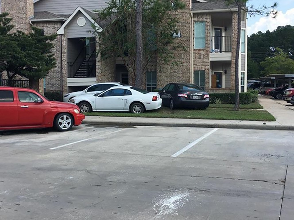
Car at Kingwood Town Center Apartments floated out of its parking spot by Harvey. Photo by Karen Favero.
More cars floated by Harvey into new parking spots. Photo by Karen Favero.
House on Kings Trail After Harvey. Photo by Karen Favero.
Folly of High Rise Development near the Floodway
Images like these so far from the river can only make one marvel at the folly of high-rise developers who insist on building on the edge of the current floodway. They know full well that, when new new flood maps are redrawn, their property will be IN the floodway. Of course, by that time, they will likely have resold it to unsuspecting buyers who are thrilled with the river views.
Underscoring Urgent Need for Flood Mitigation
If you have pictures that you would like to share, please send them to me via the Submissions Page of this web site. My thanks to Karen and Carolanne for sharing their experiences. They underscore the urgent need to put flood mitigation measures in place. It’s been more than a year and a half since Harvey and six months since the Everybody But Trump meeting in Austin. That that meeting, City officials came away hopeful that we were close to an agreement with FEMA to remove at least part of the Mouth Bar.
Sadly, not much has happened since then. But City Council Member Dave Martin, Mayor Turner and Stephen Costello have scheduled a meeting for March 21 at the Kingwood Community Center. That will be one year after Turner promised the community more gates for Lake Houston and additional dredging to reduce our flood risk.
Posted by Bob Rehak on March 11, 2019
559 Days since Hurricane Harvey
https://i0.wp.com/reduceflooding.com/wp-content/uploads/2019/03/CAN-Entry.jpg?fit=1500%2C2000&ssl=120001500adminadmin2019-03-11 17:19:302019-03-11 17:20:10The Long Reach of Harvey
A lengthy Associated Press article today talked about the long, slow demise of community newspapers around the country. Now you may ask, “What does this have to do with flooding?” It doesn’t directly relate. But indirectly, it does…or at least with the slow pace of recovery from disasters, such as Harvey.
Carolanne Norris took this shot as she and her family hiked to safety. Shot is looking back down Woods Estates near Valley Manor. Kings Forest Pool is on right. 568 days after Hurricane Harvey, her family’s flood risk remains just as high as it did before Harvey and the value of her home is half what it used to be.
Our founding fathers considered the press so important that they talked about it in terms of “The Fourth Estate,” a fourth branch of government (after the executive, legislative and judicial branches).
But with so many newspapers folding or cutting back, who’s ensuring government is doing its job?
Press as Government’s Report Card
Without someone looking over the shoulders of officials, would they act fairly? Would they spend your money wisely? Would they always follow rules?
Even with the press attending public meetings, it’s often difficult to learn how your money is being spent. Even big city newsrooms are on life support these days. Few editors rush out to do investigative stories on financial irregularities at city hall (I’m using city hall in the generic sense here). That could take months. They have a deadline at five. It’s much easier and more profitable to run a story on grandma’s nut bread recipe, or the best barbecue in Houston. Now there’s some real meat for people to sink their teeth into.
Link Between Editorial Costs and Ad Revenues
One of my local heroes is Cynthia Calvert, owner of the Tribune newspapers. I’ve seen Cynthia and her reporters at many local meetings when not one other soul shows up. School board meetings have to be the worst. This costs Calvert money. Not only to cover the meeting. But to print the story later and distribute it. And since she distributes her paper free of charge, she needs to sell a lot of ads to cover the cost.
Most newspapers closely watch their advertising-to-editorial ratio. If ad revenue dips, editorial must get trimmed. It takes financial courage to have a reporter investigate a story for weeks that may lead nowhere and have no payoff.
Mitigation Molasses
Against this backdrop, ask yourself why the city has been so slow to implement mitigation efforts since Harvey. Is it all the fault of other branches of government moving too slowly as the City would have you believe? Or is the City missing opportunities? Why can’t we get weekly updates on the status of mitigation efforts? Why will no one set deadlines and stick to them?
One thing is for sure. When Dave Martin holds his town hall meeting on March 21st, we’ll get the story that he, Costello and the Mayor want us to hear. Members of the press will dutifully report whatever they say. But how many will report what they don’t say and why?
How to Get Better Government
If you want better government, if you want faster flood mitigation, subscribe to your local newspaper and tell the editor you want answers. And for paper’s like Cynthia’s, make sure you tell local merchants how much you appreciate merchants who support their local papers with advertising. The payoff may not be immediate. But the connection is there. When officials know someone is watching, they’re on their best behavior.
Posted by Bob Rehak on March 10, 2019
558 Days since Hurricane Harvey
https://i0.wp.com/reduceflooding.com/wp-content/uploads/2019/03/CAN-KF-Pool-e1731972288338.jpg?fit=1100%2C825&ssl=18251100adminadmin2019-03-10 18:58:542019-03-10 19:34:45Decline in Readers and Ads Leads Hundreds of Newspapers to Fold. So What’s the Connection to Flooding?
Two weeks ago, when the San Jacinto River Authority reconsidered whether to lower Lake Conroe seasonally again this year, I put out a call for pictures from Harvey. I wanted the people of Lake Conroe to see how much the people of Lake Houston suffered from floodwaters. The community responded with dozens of images. I have just now finished posting the last of them on the Submissions page. If you’ve never been to this page before, check it out. The images speak volumes…silently.
Submissions from Karen Hudak
As I edited Karen Hudak’s pictures, I could almost feel what must have been her panic. Waking up in the dark to see water creeping up. Scrambling to elevate belongings. Pausing to photograph a panicked deer. Peering out a second story window to see how bad things were. Loading up a truck to escape then finding the water was rising too fast to get away.
Night of the Intruder. By Karen Hudak.
Barrington Homes about to be Engulfed as Harvey’s Floodwaters Rose. By Karen Hudak.
Sheltering in Attic as Harvey’s Floodwaters Rose in Utility Room. By Karen Hudak.
Deer Seeking Shelter During the Storm. By Karen Hudak.
Rescue Truck that Needed Rescuing. Photo by Karen Hudak.
No Go. Photo by Karen Hudak.
Submissions by Diana Aston
Diana Aston also submitted several pictures that captured the overwhelmingness of the event. They capture floodwaters rising outside, engulfing homes, swallowing cars, and her garage. And finally the return to shattered dreams…down the toilet.
16th Hole Marker, Kingwood Country Club Lake Course, As Harvey’s Floodwaters Rose. By Diana Aston
Flooding Cars in the Barrington during Harvey by Diana Aston
A Losing Battle. Harvey’s Floodwaters Creeping into Barrington Garage by Diana Aston
Toilet after Harvey Flood. By Diana Aston.
My thanks to Karen and Diana for allowing me to share their pictures with the world.
To see more pictures submitted by others, browse through the gallery on the Submissions page. To share your images with the world, follow the instructions on the page.
Posted by Bob Rehak on 3/9/19 with photos from Karen Hudak and Diana Aston
557 Days since Hurricane Harvey
https://i0.wp.com/reduceflooding.com/wp-content/uploads/2019/03/image4-e1552182578172.jpeg?fit=1224%2C1632&ssl=116321224adminadmin2019-03-09 20:51:002020-01-17 10:23:13Night of the Intruder: More Reader Submissions
Houston City Council Member Dave Martin announced today that Harris County Flood Control District (HCFCD) will begin demolition of several home-buyout properties in Forest Cove next week.
What 240,000 CFS can do to steel and stone.
The demolition in the Forest Cove Town Home community will begin with units:
803 and 805 Timberline Court
1060 Marina Drive
HCFCD plans to submit the demolition request for 1050 Marina Drive shortly.
Units in the Forest Cove townhome association destroyed by Harvey.
County Completing Buyouts
Currently there are several other units that are almost completely under HCFD’s ownership. When they are completely owned, their demolition will follow.
Martin thanked City of Houston Department of Neighborhoods Director TaKasha Francis for her assistance with expediting the demolition permits.
Within a few years, this could become part of Harris County’s new Edgewater Park.
“These town homes are a constant reminder to the community of the devastation caused by Hurricane Harvey,” said Martin. “HCFCD has done a tremendous job in keeping our office informed on the status of the demolition process for these Hurricane Harvey buyout properties.”
To learn more about HCFCD’s buyout program, visit their website.
Harvey swept away several of the townhomes in this area, leaving nothing but the foundations. Owners of several of the surviving units reported water as high as 17 to 22 feet at the peak of the flood.
Perched on the precipice with a waterfront view.Before the City picked up the trash. After Harvey, the townhomes became a convenient location for illegal dumpers, looters and squatters.
A Metamorphosis in the Making
I will cover this story as it develops. I have talked with both Harris County County Precinct 4 Commissioner Jack Cagle and the City of Houston Parks Board about this area. It’s about to undergo a metamorphosis. Within several years, this could become part of beautiful riverfront park that adds new luster to the community, provides a recreational resource to residents, and puts distance between homes and future floods.
Posted by Bob Rehak on March 8, 2019
556 Days since Hurricane Harvey
https://i0.wp.com/reduceflooding.com/wp-content/uploads/2019/03/SJR_304_018.jpg?fit=1800%2C1200&ssl=112001800adminadmin2019-03-08 17:50:542019-03-08 17:51:12Demolition of Home-Buyout Properties in Forest Cove Scheduled to Begin March 11
Seitzinger states in the opening that flooding cannot be eliminated when you get as much rainfall as we did with Harvey. But then goes on to say that, “There may be ways to limit the flooded areas in future.” His paper is intended to provide a better understanding of what happened. He hopes this will help design remedies that make the area more resilient to flooding.
River Obstructions Creating Backwater Effects
Seitzinger identifies six river obstructions creating backwaters:
The narrow Riverway near Lonestar College/Kingwood
The I-69 Bridge
A sand bar by the Kingwood Country Club
The Stream Mouth Bar
The 1960 Bridge
The Lake Houston Dam
He then spends the next 70 pages analyzing what happened at each of these during the flood and developing various strategies to deal with them. He breaks his recommendations up into short- and long-term.
Short-Term Recommendations
Short term recommendations include:
Establishing a regional authority to provide multi-county coordination on legislative, operation, mitigation and funding efforts for flood control
Reviewing and updating SJRA and CWA water release protocols.
Installing additional water-flow and level gages on the tributaries and Lake Houston with predictive flow algorithm.
Providing a better flood warning system for the general public.
Reviewing and legislating new sand-mining procedures and enforcement fines to prevent sand loss into the rivers during high water
Reviewing communications. Include clear regional decision maker assignments and house-to-house warnings for all homes in the floodway and below the 100 yr. levels at a minimum
Removing West Fork sand bars to re-establish main channel flow
Annual West Fork maintenance dredging.
Long-Term Recommendations
Longer-range recommendations for investigation and implementation include:
Dredging to return channel depths in West Fork and East Fork to original depths
Adding additional, controlled, water-release capability to Lake Houston
Widening the 59 bridge and FM 1960 bridge channels
Widening the 59 bridge and West Lake Houston Parkway bridge entrance and exit channels
Stopping flood plain re-development west of Hwy 59
Setting new regulations for storm zoning and land reservation
Adding controlled storm reservoirs to Cypress, Spring, and Lake Creeks and East Fork
Develop public-private partnership for river-sand removal and reclamation.
Limitations of Study
Seitzinger’s presentation is very technical; it is not easy reading. He targets other engineers with this and requests peer review.
One thing that will require validation: his velocity calculations. They seem at odds with velocities reported by rescue workers. I talked to an HPD officer, for instance, who estimated velocity in the vicinity of the West Lake Houston Parkway Bridge at 10 to 20 miles per hour. By calculating peaks as they moved downriver, Seitzinger estimates 1.03 mph. The difference could have to do with water jetting through the bottlenecks that Seitzinger describes. Unequal distribution of rainfall across upstream tributaries could also affect offsets among downstream peaks. Regardless…
Value of Study
Seitzinger provides all the data for others to check his calculations. The main value of an effort like this is that it collects all the crucial data in one place for posterity, cross-examination and comparison.
Kingwood is lucky to have many talented engineers, such as Seitzinger. This should stimulate much discussion.
Posted by Bob Rehak on 3/8/2019
556 Days since Hurricane Harvey
https://i0.wp.com/reduceflooding.com/wp-content/uploads/2019/03/Screen-Shot-2019-03-08-at-2.14.26-PM-copy.jpg?fit=1500%2C857&ssl=18571500adminadmin2019-03-08 14:56:452019-03-08 15:11:35Seitzinger Contributes Second Study on Harvey, Addressing Timing and Backwater Issues
The U.S. Army Corps of Engineers supplied this graphic. It updates the public on the latest dredging progress.
Two dredges, moving west to east (left to right), expect to complete dredging by the end of April, seven weeks from now. It was originally a nine month project scheduled to end around April 1, but heavy weather and multiple floods during December and January set the contractors back.
Great Lakes Dredge and Dock operates the red dredge that started at River Grove Park and is working its way toward the project midpoint.
Callan Marine operates the blue dredge that started at the midpoint and is working its way toward the end.
With roughly 50 days remaining (about 15-20% of the time depending on how many weather days you allow), the corps appears to be about 70% done. That means they must hustle to make up time. The contractors are already working 24/7.
Parents who want to give their kids a treat can take them down to Kings Harbor to watch the dredging. I was there today. It is truly impressive. There’s lots of big equipment on the river moving more sand than the Astrodome can hold. They’re pumping it miles upriver to two old sand pits.
While at Kings Harbor sample some frozen yogurt or one of the restaurants that recently re-opened. Please support the local merchants who bet their financial futures to make your life a little more enjoyable.
Yesterday, I learned about re-traumatization of people suffering PTSD (post-traumatic stress disorder) from Harvey. I had contacted Janice Costa, one of Kingwood’s leading psychotherapists to gain some insight. Keep in mind as you read this that neither Costa, nor I, have any idea how widespread this phenomenon is. However, Stephen Costello, the City of Houston’s flood czar, while speaking to a symposium on flooding at the University of Houston last year stated that 18% of Harris county’s residents suffered some sort of serious psychological distress after Harvey.
From presentation by Stephen Costello to Houston Geological Society in 2018 during a symposium on Flooding in Southeast Texas: The Science Behind the Floods. Costello said 18% of Harris County residents were suffering from “serious psychological distress” after Harvey.
I pointed out to Costa how the traffic on my site spiked when I posted The Night 11,000 Lake Houston Area Residents Became Homeless. Thousands of people have viewed it in the last week and are still viewing it. In fact, it’s my most popular flood post ever with the exception of the one with that snappy headline, Public Notice.
Trash Day in the Barrington after Harvey. Photo by Joy Dominique.
What Did I Tap Into?
I had accidentally tapped into some powerful emotions, but I wasn’t sure what or why and hoped Costa could help. Costa said victims sometimes feel such images and stories “validate” what they went through. “Yes! See. It was that bad!”
In the case of Harvey, it’s difficult for some people to let go, because they are constantly getting “re-traumatized” from related sources, she says. The examples below represent my interpretation of what she said, not literally what she said. I added dozens of examples that people have shared with me along the lines she mentioned.
Re-Traumatization, Day after Day
As if Harvey weren’t a big enough disaster, how about these complications? Do any of them sound familiar?
Flooding, but not having flood insurance, because you thought you were safely outside the 500-year flood plain
Power outages, spoiled food, Igloo coolers and grilling in the rain
Food lines, second-hand shops and shelter life
Separation from families, not being able to find loved ones in the shelter system
Loss of important papers, tax documents, and family albums
Losing the Bible that had been in your family for five generations
Gutting your own house, often with the help of strangers
Not being able to monitor everything they dragged to the curb
Seeing your life’s work piled on the street and picked over by looters
Your first Christmas without wallboard
Family heirlooms destroyed
Showering with a garden hose
Being displaced and dispossessed
Being forced to accept charity instead of feeling privileged to give it
Finding temporary lodging with friends, family or in hotels
Moving every few weeks so you didn’t wear out your welcome
Finding a vehicle and then finding out it had concealed flood damage
Stress at work from not being able to focus on your job while you rebuilt your life
The bad performance review at work that you knew was coming
Losing a business
Kids who cried themselves to sleep every time it rained
Breaking out in a cold sweat when you hear a helicopter
Feeling guilty about not being able to thank all the people who helped you
The two extra hours a day you didn’t get to spend with your kids because they were being bussed cross town to another high school.
Report cards that showed plummeting grades because your kids were traumatized
Educational handicaps that your kids may face for the rest of their lives as a result of effectively losing a year
Living in a camper
Your insurance benefits running out before repairs were completed
Losing your job
Losing your mind
Losing your spouse from all the stress
Trying to find money to rebuild
Living out of your car
Not having a car to live out of
Battling with the insurance adjuster
Battling with FEMA
Looking for help and battling a million other people looking for help
Struggling to find a contractor
Struggling to get the contractor to show up and do the work
Giving up the family vacation to supervise a contractor who didn’t show up
The contractor who ran off with your check
Finding out that the contractor hung your new front door upside down
Shoddy repairs with inferior materials
The City inspector who said the contractor did it all wrong
Lung ailments from breathing that unique Houston brew of mold, varnish, plaster dust and Clorox
Seeing friends and relatives succumb to the stress
Friends moving away to escape the stress
Going to the laundromat and using the machine next to the guy who was washing the clothes he had on
Living upstairs for a year and a half
Using your garage as a walk-in closet
Actually beginning to think of Taco Bell as haute cuisine
Learning to cook with a hot plate and a microwave
The stress zit that looked like a third eye in your forehead
Your favorite stores and restaurants being out of business for a year … or disappearing altogether
Going to college classes in a rented warehouse
Commuting two extra hours a day because the 59 bridge was out
Draining your retirement funds to rebuild
Then finding that wasn’t enough and tapping into your kids’ college funds
Not knowing how you’ll replenish them
Gaining 20 pounds from Chunky-Monkey stress relief
Jaw and neck pain from constantly grinding your teeth
FEMA and HUD help that arrived after you’d already rebuilt your home
Discovering that you lost all your repair receipts
Aches and pains from doing-it-all-yourself
Learning to love scratch-and-dent sales
Refurnishing your house from “Flooding Kingwood with Kindness”
Losing someone to cancer or heart-disease while trying to cope with everything else
The neighbor that abandoned the house next door…affecting your home’s value
Fearing what the next storm front could bring
My apologies to anyone I omitted!
More Re-traumatization!
Now consider the political systems around you. While we struggled individually, government offered help. Then came other kinds of re-traumatization.
The money from the drainage fee that wasn’t there when the City needed it to jumpstart flood mitigation projects
Being told you could build a firewall around drainage fees by approving the same leaky-bucket, Prop-A language that led to the problem in the first place
Learning that it took FEMA, the SJRA, Montgomery County, Harris County, and the City of Houston a year to fund a $2 million San Jacinto watershed study.
Wondering what that portends for the future of other flood mitigation projects
Watching that wonderful feeling of post-Harvey bipartisanship degenerate into political bickering while you…
Fear what the next storm could bring
The Lifeboat Mentality
In my opinion, people are looking for help and seeing hurt ahead. Many SAW the flood bond as a lifeboat. It buoyed their hopes and dreams for a return to safer shores. They were counting on the mitigation projects in it to protect them. Now, they feel thrown overboard by the struggle over prioritization of projects, i.e., who gets theirs first.
Our county judge called it “class warfare.” Fox News called it “bait and switch.” I call it maddening. I think residents rich and poor would agree.
Residents who suffer from PTSD, have suffered re-traumatization – so severely, so many times – that they may feel there is no escape. Political jousting just re-traumatizes them.
No one is telling them that more than half of the flood bond projects have started already.
Meanwhile, depression, anxiety and related illnesses are starting to surface. One of my dear friends lost her home to Harvey, her husband to cancer, and now is struggling with cardiac issues as she tries to rebuild her home. Alone.
Turning Negatives into Positives
Costa did offer a ray of hope. Some people have managed to find something positive in the flood experience, she said. For instance, those intent on remodeling might suddenly have the insurance money to do it.
One of my dreams is that Republicans and Democrats find a way to work together again. Maybe, collectively, we’ll find a way to create a functioning government that reduces flood risk and restores a sense of order to our lives in time to handle the next big hurricane. I think that would be a positive outcome from all of this. For all of us.
Posted by Bob Rehak on March 7, 2019 with help from Janice Costa
555 Days since Hurricane Harvey
https://i0.wp.com/reduceflooding.com/wp-content/uploads/2019/03/Screen-Shot-2019-03-07-at-3.13.11-PM-copy.jpg?fit=1500%2C913&ssl=19131500adminadmin2019-03-07 16:09:052019-03-07 18:52:14PTSD, Re-Traumatization, a Lifeboat Mentality and Flood-Bond Politics
Janet Botello, a USACE Evaluation Branch Chief, provided the following explanation about next steps in the Army Corps’ permit evaluation for the high-rise marina project in Kingwood.
High-rise marina project is at a cross-roads. Harvey Photo by Jay Muscat.
30 Days For Applicant to Respond
Said Botello, “As the comment period has closed, we are providing the applicant with those public comments we’ve received. Applicants have 30 days to respond to those issues and concerns raised during the comment period.”
Next Steps Contingent on Applicant Responses
Botello continued, “Once we receive those responses, we will be in a better position to determine if a public hearing will be held.”
Ms. Botello also stated, “If we determine that additional information is needed for us to make a decision on this permit application that has not been already gathered from the public or applicant through our public interest review process, the Corps may decide to hold some type of public meeting.”
The Corps did not give a firm deadline for the decision on a public hearing.
Assuming that:
It takes a week or two to log, parse, process and transmit all the comments to Romerica…
And that it takes Romerica another month to respond…
And that it takes the Corps a few weeks to review their responses…
…my guess is that we should be hearing from the Corps in May as to whether a public hearing is needed.
They also leave open the possibility that a public MEETING may be needed if they need even MORE information/input. Please note: the Corps draws a distinction between public hearings and public meetings.
Difference Between Hearing and Meeting
At a hearing, citizens state their complaints and the Corps listens, but makes no comment and asks no questions. A meeting, on the other hand, is more of a dialog. The meeting Romerica scheduled is NOT the meeting that the Corps refers to.
I am told by people who have worked these kinds of issues with the Corps before that it can take months before a final decision is rendered. One engineer suggested it could take the rest of this year. The Corps did not provide a total time estimate.
To see the original public notice with project specs, maps and details, click here.
Posted by Bob Rehak on 3/5/19
554 Days since Hurricane Harvey
https://i0.wp.com/reduceflooding.com/wp-content/uploads/2019/02/KingwoodGreens-e1551452236612.jpg?fit=1500%2C1038&ssl=110381500adminadmin2019-03-05 21:21:242019-03-08 11:15:15Next Steps for Army Corps in Evaluating High-Rise Permit Application
Mark your calendars. Monday, March 18th, 6:30 to 8:30 P.M. at the Kingwood Community Center.
The invitation reads, “Kingwood residents and interested parties are cordially invited to come and learn about The Herons development. This will be a great opportunity to meet the developer and his team. The main discussion topics will be:
USACE Corp Process
Phases of the Development
Current and Future Initiatives of Romerica”
GUEST PANEL INCLUDES:
R. Thomas Sankey, PWS, CSE Senior Project Manager / Senior Ecologist, SWCA
Melvin G. Spinks, P.E., CFM, President, Civil Tech Engineering, Inc.
Gabriel Haddad, Developer, Romerica
“Free” Meeting
Aside from saying that the meeting is “free” and open to the public, they don’t say much more. For instance, it’s not clear whether the panel members will take questions from the audience.
The public comment period for this closed on March 1. But I did think it was sporting of them not to charge admission.
Personally, I kind of wish they were addressing the issue of evacuation.
Woodland Hills Drive During Harvey by Julie Yandell. Evacuation is not on the agenda published by the developers.
No New Info Yet from Corps
The Corps has not yet responded to questions about whether they will hold a public hearing related to this project, whether a Corps represetative will be there, or when the Corps intends to rule on the permit. This is NOT a Corps meeting.
Posted by Bob Rehak on March 4, 2019
553 Days since Hurricane Harvey
https://i0.wp.com/reduceflooding.com/wp-content/uploads/2019/02/IMG_0125.jpg?fit=1500%2C2000&ssl=120001500adminadmin2019-03-05 17:59:372019-03-05 18:06:40High-Rise Developer Sets Public Meeting … After Close of Public Comment
Decades ago, I had a house that flooded due to frozen pipes. It wasn’t pretty, but it was expensive. So this warning goes out to all those residents who may still be working on flood repairs and don’t yet have insulation back in place.
ALERTHOUSTON Freeze Warning Issued for Houston from Midnight – 9 AM Tuesday
Weather Information The National Weather Service has issued a Freeze Warning for Houston from midnight to 9 a.m. Tuesday, March 5. As of 6PM, Monday, NWS predicts temps in the City could go down to 27 degrees.
In northern counties, though, the situation is more severe. Temps could fall below freezing by 9PM and go as low as 24 along a line from Brenham to Livingston.
A Freeze Warning means sub-freezing temperatures are highly likely. Cold weather can pose a danger to the health and safety. Proper care should be taken to reduce exposure to these conditions.
Protective Actions
When cold weather occurs, Houstonians should remember to protect the Four ‘P’s: People, Pets, Pipes, and Plants.
People
Dress in warm, layered clothing, including gloves, a coat, and a hat when you are outside.
Never leave children or the elderly in vehicles during cold weather, as they can act as refrigerators and expose anyone inside to sub-freezing temperatures.
Never use a generator, grill, camp-stove, or any gasoline, propane, natural gas or charcoal-burning device to heat your home (or any enclosed area). These devices can generate carbon monoxide, which cannot be seen or smelled, but is deadly.
Check on family, friends, and neighbors who may be susceptible to this week’s cold weather and/or not have access to housing and heating, including the elderly and those with special needs.
The Coalition for the Homeless is coordinating information for partner agencies and the general public and is keeping an updated list of those resources for individuals who may be experiencing homelessness:
Pets
Protect your pets by ensuring that they have a warm, safe place to sleep. The best place for a pet to sleep is in a heated environment.
Do not shave your dog down to the skin in winter. A longer coat provides more warmth.
Never leave your animal in a car during cold weather. Cars can act as refrigerators in the winter, holding in the cold and causing animals to freeze to death.
During cold weather, pipes may freeze and rupture, causing water leaks and damage to your home. Protect your home by opening the cabinets under kitchen and bathroom sinks to allow air from your home’s heater to warm the pipes under the sink.
Insulate outdoor faucets and pipes with insulation or newspaper, and be sure to disconnect and drain hoses from outdoor spigots.
Plants
Protect plants from freezing by covering them with plant-cover fabric, or a light blanket with plastic sheeting on top of it.
Bring in potted plants or group them together, near the edge of a building. Remember that soil in containers can get just as cold as the air temperature, and cause the roots to freeze, even if the above-surface leafs survive.
Sign Up for Alerts
AlertHouston is the City of Houston’s official emergency notification service. For updates on this situation, visit houstontx.gov/emergency.
After having my pipes freeze once, I never wanted it to happen again. So I set my faucets to drip at a slow rate whenever we get a hard freeze warning like this. Remember, hot water freezes before cold, so it’s most important to drip your hot water faucets – if you are going to do it. This is counter-intuitive. It’s like something out of Roswell. But it’s real. It’s called the Mpemba Effect. I’m sure all of the science classes in the Humble ISD will be buzzing about this tomorrow. In the meantime, good luck tonight.
Posted by Bob Rehak on March 4, 2019
552 Days after Hurricane Harvey
https://i0.wp.com/reduceflooding.com/wp-content/uploads/2019/03/image.png?fit=400%2C400&ssl=1400400adminadmin2019-03-04 18:03:322019-03-04 18:13:19Watch Your Pipes Tonight!