Provisions for Off-Site Overland Sheet Flow in Montgomery County Drainage Criteria Manual Warned Perry Homes of Dangers to Elm Grove
Section 5.3.5 of the Montgomery County Drainage Criteria Manual (Pages 83-84) specifically address flooding of established subdivisions by land under development. For example when Elm Grove was flooded from clearcut land in Woodridge Village. Had Perry Homes, its subsidiaries and contractors followed the requirements in the Manual, Elm Grove might not have flooded.
Provisions Adequate for Ultimate Development Can Be Severely Deficient for Intermediate Stages
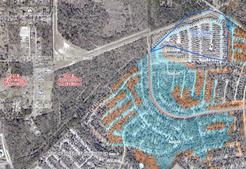
The section on Offsite Overland Flow starts out by saying, “Sheet flow from undeveloped areas into an existing or a proposed subdivision can create a localized flood hazard by overloading street inlets and/or flooding individual lots.” This is exactly what happened to Elm Grove Village and North Kingwood Forest in May and September of this year. City of Houston storm drains already taxed to the max became overloaded when water broke out of Woodridge Village and started flowing down the streets of Elm Grove and North Kingwood Forest.

The text in the Drainage Manual then continues. “Any drainage plan for a proposed subdlvision submitted for review and approval by the Montgomery County Drainage Administrator must address the drainage of all adjacent lands. Both under undeveloped and fully developed conditions. A plan which may be adequate under conditions of ultimate development can be severely deficient during intermediate conditions of development due to sheet flow from adjacent undeveloped land. Provisions must be made to divert 100-year sheet flows to a channel system or to the secondary street and storm sewer system.” [Emphasis added.]
The LJA Drainage Analysis claimed Woodridge would create “No adverse impacts to neighboring developments or Taylor Gully.” However, the LJA analysis did not:
- Discuss the drainage of adjacent lands, such as Elm Grove.
- Discuss intermediate conditions of development; they focus only on fully developed Phase 1 and Phase 2 Conditions.
- Mention the phrase “sheet flow” once.
- Make provisions to divert 100-year sheet flows.
No Swales to Redirect Sheet Flow
The next paragraph of the Montgomery County Drainage Criteria Manual starts, “Redirection of the sheet flow can usually be achieved through the use of drainage swales located in temporary drainage easements along the periphery of the subdivision.” Perry Homes built no such swales … at least not adequate ones.
No Berms to Block Sheet Flow
Later in that same paragraph, the Manual talks about building berms between the swales and adjoining neighborhoods to prevent the flow from overrunning the swale. Unfortunately, on May 7th, no such berms existed. They did for Imelda, but they proved inadequate to divert the sheet flow and they had gaps in them.
No Additional Storm Sewer Capacity
The next paragraph talks about building “additional inlet and storm sewer capacity … to prevent prolonged street ponding in the (neighboring) subdivision resulting from flow from the undeveloped area.” That didn’t happen either.
No Planning for Rain Before Detention Ponds Fully Built
Perry Homes took none of these precautions. LJA never planned for them (as far as I can see from publicly available documents). Reading LJA’s drainage analysis, one gets the impression that no one ever even conceived of rainfall before they could build all the detention ponds for Woodridge Village. That turned out to be yet another fatal assumption. Despite all the warnings and mitigation advice in Montgomery County’s Drainage Criteria Manual.
Add this to a long and growing list of other things they ignored, underestimated, or mischaracterized.
- Best management practices for clearing land
- Presence of wetlands
- Need to get wetlands clearance from Army Corps
- High clay content in soil
- Runoff potential
- Temporary vegetation during construction
- Erosion control
- Rainfall rates
- Completion of detention ponds
Stay Tuned for More
The list goes on and on. I have barely started. This series could last for weeks. The MoCo Drainage Manual goes on for almost 200 pages. And Woodridge Village is far from the only Perry Homes Development.
Perhaps the biggest question in all of this is for the Montgomery County Judge and Commissioners. How do plans like this get approved?
Posted by Bob Rehak on 11/12/2019 with thanks to Jeff Miller
806 Days since Hurricane Harvey and 55 since Imelda
The thoughts expressed in this post represent opinions on matters of public concern and safety. They are protected by the First Amendment of the US Constitution and the Anti-SLAPP Statute of the Great State of Texas.
For those who are interested, I have reprinted verbatim the full text of Section 5.3.5 from the Montgomery County Drainage Criteria Manual below.
Sheet flow from undeveloped areas into an existing or a proposed subdivision can create a locallzed flood hazard by overloading street inlets and/or flooding individual lots. Any drainage plan for a proposed subdlviston submitted for review and approval by the Montgomery County Drainage Administrator must address the drainage of all adjacent lands. Both under undeveloped and fully developed conditions. A plan which may be adequate under conditions of ultimate development can be severely deficient during intermediate conditions of development due to sheet flow from adjacent undeveloped land. Provisions must be made to divert 100-year sheet flows to a channel system or to the secondary street and storm sewer system.
Redirection of the sheet flow can usually be achieved through the use of drainage swales located in temporary drainage easements along the periphery of the subdivision. As the adjacent area develops to the point at which the street system can effectlvely handle the sheet flow condition, the temporary drainage swales and easements may be abandoned.. The drainage swales should be relatively shallow, with the excavation spoiled continuously along the subdivision side of the swale to prevent flow from overrunnmg the swale. The swale should have sufficient grade to avoid standing water, but not enough to create erosion problems. Generally, a minimum. grade of 0.1% should be maintained with the maximum grade strongly dependent on local soil conditions.
Such temporary drainage swales may be directed to inlets in the storm sewer system or, preferably, to the appropriate primary outfall channel. lf an undeveloped area is to be drained to a storm sewer, additional inlet and storm sewer capacity must be provided to prevent prolonged street ponding In the subdivision resulting from flow from the undeveloped area. Provisions for this flow must also be included in the design of the street drainage overflow system. The design of temporary drainage swales directed to Montgomery County drainage channels must include adequate provisions to drop the flow into the channel through an approved structure in order to avoid excessive erosion of the channel banks.
Outfalling the temporary swale into the backslope drainage system for the channel is unacceptable because the backslope drainage interceptor structures are not adequate to convey flow from an off-site swale. A typical approved structure is shown in Figure 6.3, With the exception of the pipe dimension. The pipe must be sized to handle the 100-year flow from the off-site area.