After 2.5 years of examining photos and videos of the so-called “dikes” in sand mines, I have come to believe that some are designed to fail. In some cases, mines cause them to fail.
In most cases, the “dikes” are not really dikes. They’re just the edges of pits that miners have excavated. Or roads around the pits made of sand that easily erode.
And because miners mine so close to the river, when those pits fill with water, they overflow. The resulting erosion cuts channels between the pit and the river that allow the pits to discharge a portion of their wastewater. Lake Houston and public drinking water become collateral damage.
High Cost of Flimsy Construction
After the storm, miners throw some sand in the breach and wait for it to happen again. The sand creates only the appearance of a fix.
Month after month, I’ve photographed active breaches, “patched” breaches, and scars in the landscape from older breaches. Many reopen multiple times.
Breaches are so common that, in my opinion, they may be part of some miners’ business plans.
High Cost of Silt
If discharges consisted of plain water, I might not care. But the water usually carries silt with it. Miner’s settling ponds can fill with silt which has little marketable value. Flushing it downriver solves another problem.
Miners externalize their cleanup costs by foisting them off on an unsuspecting public. That sediment clogs rivers that must be dredged to avoid flooding. It reduces the capacity of the lake. And it escalates the City’s water treatment costs.
A retired high-level Public Works manager told me he routinely investigated and found breaches at sand mines during floods. In his opinion, many of the breaches were intentional and the floods created the perfect “cover” for the illegal discharges. “Blame it on Mother Nature,” he said.
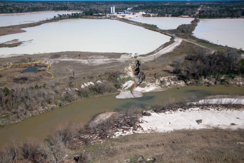
West Fork Images from February Flyover
Below, a sampling of more than 1000 images I took on 2/13/2020. The first batch shows mines on the San Jacinto West Fork between SH242 and US59. I traveled NW to SE toward 59. I’ve arranged images in the same order.
Sand mine pond and water’s path to the river (right).Pond is full to the brim and will overflow on a minor rain.
Another angle looking north toward the same breach.
West Fork is migrating toward pit on right and will soon enter it. A powerful argument for reasonable setbacks from river.
Another pond at the same mine. The only thing holding back another illegal discharge is a feeble road made of sand. See close up in next pic of area near poll just left of center.
Close up of road in upper left of previous photo. Note how water seeping through it is already causing road to collapse.
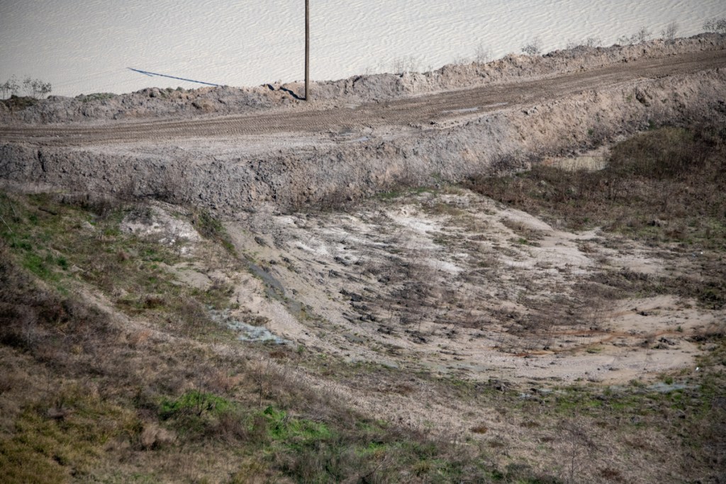
Silt spreading into settling pond. See also reverse shot below.
Reverse angle from previous shot, but same pond. See West Fork in background and note how road in foreground was cut by spreading silt.
Site of previous double breach at RGI mine. Note gray area in second row of dikes. Process water from the pond behind it broke into the settling pond in the foreground and from there into the West Fork. TCEQ cited owners.
Two separate ponds may have shared this same “wash” to the river (foreground). Pond in middle right is actively discharging into river. See reverse angle in next shot.
Same discharge as in previous shot. From this angle it is easier to see the active discharge.
Same breach from third angle. From this angle, you can clearly see the path and the discharge.
This pond has been discharging into the river for months. Note the difference in the color of the river water and discharge water. This indicates the discharge water is still holding silt.
Reverse shot of same breach highlights both the path and the color difference of the discharge.
This pond is leaking into a drainage channel that parallels Northpark Drive south of Oakhurst.
Former breach at Eagle mine on Sorters Road. West Fork in foreground.
Scars from previous breaches. One of these was intentional, though I’m not sure which. See video below.
Video by resident who wishes to remain anonymous shows intentional breach at the mine above.
Another scar from previous breach.
Confluence of Spring Creek (left) and West Fork San Jacinto (right).Facing west.Note color difference in water. It’s frequently visible.
Same area looking southeast toward Humble.West Fork on left.
Same area looking NE toward Kingwood.West Fork comes in from left.Between the 59 bridge in the previous shot and this area, the Army Corps spent more than $90 million removing sediment from the West Fork. The City, County and State could spend another $35 million removing this blockage.
Wider shot shows just how much forest was blown out in this breach, leading one to wonder whether this was caused solely by nature.Another former breach into Caney Creek from the Triple PG mine. Only this eroding road stands between the mine and the creek.
Also at the Triple PG mine in Porter, this breach into White Oak Creek remained open for months. It, too, was the subject the Attorney General’s lawsuit. A restraining order against the mine calls for repairs to be certified by a professional engineer. This looks as though they may have tried to add concrete to the sand and stabilize it with rebar. However, note that the concrete, if that’s what it is, doesn’t rise much above the water. The road is made from eroding sand that will blow out in the next storm.
Reverse shot of same breach looking west. No concrete or rebar visible here – only rilling along steep sides of road. Rilling is the term for those vertical erosion channels.
Posted by Bob Rehak on 2/24/2020
909 Days since Hurricane Harvey and 158 since Imelda
The thoughts expressed in this post represent opinions on matters of public concern and safety. They are protected by the First Amendment of the US Constitution and the Anti-SLAPP Statute of the Great State of Texas.
https://i0.wp.com/reduceflooding.com/wp-content/uploads/2020/02/20200213-RJR_7753.jpg?fit=1200%2C800&ssl=18001200adminadmin2020-02-24 15:22:182020-02-24 15:29:12Are Sand Mine Dikes Designed to Fail?
In the last month, workers made progress on pipeline bed repairs to two area sand mines. But repairs at one sand mine look substantial. At another, they look superficial. Triple PG in Porter is still edging into the danger zone.
Exposed by Erosion When Mining Came Too Close
In December and January, I posted about pipelines exposed when sand miners mined too close to them. Floodwaters then swept through the mines and undercut the pipelines, creating safety hazards.
Pipelines exposed by erosion at Liberty Materials Mine in Conroe. Photo taken January 20, 2020.
Several HVL (highly volatile liquid) pipelines (above) and one natural gas pipeline (below) were affected at mines in Conroe and Porter.
Exposed natural gas pipeline at Triple PG mine near Caney Creek in Porter. Photo taken December 3, 2019.
Here’s where things stand on repairs at both mines as of last week..
Triple PG Mine in Porter: Another Big Cover Up
The Triple PG Mine in Porter has covered up the exposed natural gas pipeline with sand. As of 2/13/2020, Triple PG had made no other visible attempts to stabilize the area, which is subject to repeated erosion. Harvey first exposed the pipeline, which Triple PG subsequently covered. Then Imelda re-exposed it. And Triple PG re-covered it.
Fresh sand covers exposed natural gas pipeline. Will it be washed away a third time in the next big storm?
Readers may remember that after Harvey, Kinder Morgan tunneled 75 feet under the mine and spliced in a replacement for the section that had been exposed. They then filled the cutoff section with inert gas. So the exposed section was not active.
Still, without further stabilization, the pipeline will likely be exposed again and again by future storms.
Triple PG still has made no attempt to stabilize erosion creeping toward the HVL pipelines that cross the mine in a utility corridor. The same erosion that exposed the natural gas pipeline will threaten those in future storms.
Five pipelines carry highly volatile liquids through this utility corridor. Triple PG mines sand from either side of them. During floods, Caney Creek runs through this mine creating the erosion you see here.
Liberty Materials Mine in Conroe: Fix Nearing Completion
At a Liberty Materials Mine in Conroe, a much more substantial fix is underway by the pipelines. The mine spanned both sides of the utility corridor. Water from one side, trying to get to the river on the other, washed under several HVL pipelines, exposing them.
Repairs began in January and were well under way in February. Crews first expanded the washed out area under the pipelines. Then they placed two giant culverts under the pipelines to allow water to move from one side to the other. They also cemented the culverts in place and drove vertical steel reinforcements in the ground to prevent re-exposure of the pipelines.
Two giant culverts will now carry water under the pipelines. Shown above: the outfall.Steel reinforcements rise above the level of the pipelines to help retard erosion.Photo taken 2/13/2020.Rip rap and other reinforcements will also help retard erosion.Inlets for the culverts. Photo taken 2/13/2020.Looking west toward The Woodlands. San Jacinto West Fork is at far end of sand mine. Note all the sand and sediment that has washed under this area to the far side of the steel reinforcements.
As of 2/13/2020, crews were filling dirt in under, around and over the pipelines.
The repairs here appear much more substantial than in the Triple PG mine. I just hope the volume of sand washing from one section of the mine to the other does not clog the culverts. The steel reinforcements will protect the pipelines in this location, but water has a habit of flowing around obstacles.
Posted by Bob Rehak on 2/23/2020
908 Days after Hurricane Harvey 157 since Imelda
https://i0.wp.com/reduceflooding.com/wp-content/uploads/2020/02/20200213-RJR_7697.jpg?fit=1200%2C800&ssl=18001200adminadmin2020-02-23 10:43:352020-02-23 10:57:20Progress on Pipeline Repairs at Sand Mines
What causes street flooding? At the risk of clarifying the obvious, rain accumulates faster than storm sewers and drainage ditches can carry it away.
A Lack-Of-Capacity Issue
Most streets are actually designed to be part of the flood retention system in any community. That’s because most storm sewers can only handle a two-year rain (about 2 inches per hour). When we get more than that – say a 10-, 25-, 50- or 100-year rain – water is stored in the street until capacity opens up in the storm sewers, ditches and creeks.
As you can see from the new Atlas-14 rainfall chart below, a 2-year rain in this area is 2.23 inches/hour; a 25-year rain 3.88 inches/hour; and a 100-year rain 4.88.
New Atlas-14 Rainfall Data for Lake Houston area from NOAA
When evaluating rainfalls, look at the storm totals AND shorter intervals, such as 15, 30 and 60 minutes.
Street flooding usually results from short, high-intensity downpours caused by slow-moving or training thunderstorms.
From a street-flooding perspective, getting 4 inches of rain in one day is not the same as getting 4 inches in one hour.
If you get 2 inches of rain in 30 minutes, you’re already at a 5-year rain. That’s well beyond the design capacity of storm sewers. You can expect water to back up into the street at that point, even if there are no blockages in the storm sewers.
That’s why builders elevate most homes several feet above street level and above the 100-year flood plain. It gives you an additional margin of safety.
How To Determine Intensity of Rainfalls
If you flooded from your street, first determine whether the cause was simply overwhelming rainfall or whether complicating factors existed.
How can you determine how much rain you got in any given time interval during a storm? Follow these simple steps:
Click on the gage nearest you. (For me, that’s Gage #755 at the San Jacinto West Fork and West Lake Houston Parkway. I will use that in the example below.)
In the pop-up window, click on the “For More Information” button.
At the top of the next window, select date and time intervals. The Time Interval varies from One Hour to One Year. I selected September 19, 2019 (the day of Imelda) and 24 hours. That shows me 24 1-hour intervals. From this and the table above, you can see that we had three very intense hours in a row during Imelda.
HarrisCountyFWS.org shows we got almost 11 inches during Imelda, the vast majority of it in three hours.Note: selecting other time intervals displays other time increments.For instance the system breaks hours down into 5-minute increments, years into months, etc.
From the two charts above, correlate the actual precipitation with the recurrence intervals. You can see that…
We had a 10-year rain, followed by a 5-year rain, followed by a 2-year rain – all in three hours!
Every single one of those hours met or exceeded the maximum capacity of the storm sewers. So it’s easy to see WHY we had street flooding.
When Street Flooding Turns into Home Flooding
In a small percentage of cases, street flooding turns into HOME flooding – when there simply isn’t enough backup capacity in the streets. (In the following discussion, I’m EXCLUDING homes that flooded from rivers, streams, or overland sheet flow during Imelda, i.e., Ben’s Branch, Elm Grove, etc.).
Extreme events reveal the weaknesses in any system. If your home was:
At a low point on the street…
Near a clogged storm drain…
A foot or two lower than surrounding homes…
At the bottom of a hill…
In an area where water collected or converged…
Near an outfall pipe that collapsed or was blocked…
Upstream from a ditch that was blocked…
…you may have flooded.
And then there are the bizarre cases.
I visited one man in Trailwood at the bottom of a hill that had NO storm drains. Inexplicably, someone placed the nearest drain in the middle of the hill – about half a block ABOVE his home.
Another man called me who lived near Village Park Drive next to a tributary of Ben’s Branch. The Community Association had erected a fence between the end of the street and the tributary. They built the fence so low to the ground that it became clogged with weeds and grass clippings during Imelda and formed a dam. In the heavy rain, water could not get under it and backed up into his home.
What Can You Do?
Short of praying or digging up every street in Houston to enlarge the storm sewers, homeowners DO have some remedies.
Keep storm drains clear. Keep yard waste out of them.
Call 311 for a storm-drain inspection if you suspect yours have become clogged. The City is currently inspecting ALL drains in Kingwood subdivisions that had street flooding last year.
Inspect outfall pipes where your storm drains enter the nearest ditch to ensure they have not collapsed or become blocked.
Look out for new construction, such as the fence above, that may back water up. Remove or elevate the horizontal rot board if it blocks the overflow of water from your street.
If the problem recurs in less extreme events, consider flood proofing or elevating your home.
Make sure you have flood insurance; that it’s up to date; and that it reflects the true replacement value of your home.
Wide shot from farther up the block of fence shown above. Gap under fence did not exist at time of Imelda.Note how rot board has NOW been elevated to allow water collecting in street to get into creek beyond fence.
Great Options Where Possible
If your area floods repeatedly, you may also be interested in lobbying the City or County to build an overflow spillway or detention pond between your street and the nearest drainage channel. Obviously, geographic circumstances may rule this possibility out for many. But if you have a vacant lot in your neighborhood and a nearby ditch…
Example of community detention pond with overflow channel to Taylor Gully (beyond fence). This wasn’t enough to protect North Kingwood Forest in Imelda, but their problem was complicated by sheet flow from Woodridge Village.
Posted by Bob Rehak on 2/22/2020
907 Days after Hurricane Harvey and 156 after Imelda
https://i0.wp.com/reduceflooding.com/wp-content/uploads/2020/02/20200203-RJR_7540.jpg?fit=1200%2C800&ssl=18001200adminadmin2020-02-22 19:33:112020-02-23 04:47:14Street Flooding: Causes and Cures
In a marathon meeting last night, the SJRA modified the seasonal lowering program for Lake Conroe. The adopted motion does not exactly follow the City of Houston’s last-minute compromise recommendation. It delays lowering the lake to 199.5 feet until after September 1 to accommodate boaters and businesses on Lake Conroe. The City had recommended lowering the lake to that level beginning August 1. The old policy called for lowering the lake all the way to 199 in both months.
Details of Plan
Minutes of the meeting have not yet been approved, but here is the preliminary summary:
Spring lowering:
Lower to 200’ msl (mean feet above sea level) beginning April 1 through May 31. Recapture begins June 1.
Fall lowering:
Beginning August 1, lower to 200’ msl.
Beginning September 1, lower to 199.5’ msl.
Tropical Storm Provision:
If a named storm enters the region, City of Houston may initiate an additional prerelease to 199’ msl by requesting the SJRA to do so in writing. SJRA staff will coordinate with COH staff on the details and timing of the lowering.
Duration of Program
The program will continue through December 2022, giving the City of Houston enough time to add additional gates to Lake Houston and complete West Fork dredging.
1400 Crowd Convention Hall for 5-Hour Meeting
More than 1400 people crammed into the meeting at the Lone Star Convention Center in Conroe. The meeting lasted more than five hours. Some people arrived hours earlier to make sure they got seats.
Estimated crowd of 1400. White shirts from Lake Houston, red from Lake Conroe.
Lake Conroe residents still outnumbered Lake Houston residents by 2 to 1, but it was far better than the 20 to 1 ratio in previous meetings on this topic.
Also present at last night’s meeting were people from between the two lakes in communities such as River Plantation. More than 1100 people between Lake Conroe and Lake Houston flooded during Harvey when the SJRA released 80,000 cubic feet per second.
Flooded Protester at February SJRA Board Meeting
Plea for Civility Starts Meeting
The meeting started with a plea by the chambers of commerce from the two areas for unity and civility. And the meeting was in fact far more civilthan previous meetings on this topic. Gone was the bar room atmosphere of jeers, catcalls, name calling, interruptions, and physical threats.
Staff Presentation and Mayor’s Letter Change Debate
Before public comments began, two developments totally changed the debate. Most people expected the SJRA to decide between continuing or scrapping the existing plan. However, the evening before the meeting, Houston Mayor Sylvester Turner sent a letter to the SJRA suggesting a compromise proposal: 200 msl in the spring and 199.5 in the fall. Then Chuck Gilman, SJRA’s Director of Water Resources and Flood Management, kicked off the meeting with an alternate proposal: 200 msl in spring AND fall.
Gilman’s presentation to the board emphasized lowering the lake one foot could have prevented releases in all but three storms in the last twenty years. Gilman’s team correlated the average rise in lake level per inch of rainfall in dozens of events. See graph below.
SJRA data shows that 1-foot of extra lake level (yellow line) would handle all but three storms that occurred in last 20 years. Hurricane Harvey was excluded from graph because it was considered an anomaly.
“A review of historic rainfall data and corresponding lake rise suggests less than 2 feet of storage is adequate to catch most storm events at Lake Conroe that occur in the fall,” said Gilman.
“Only two rainfall events that occurred in the months of August and September since 1999 (excluding 2017) resulted in more than one-foot of rise in Lake Conroe. More than 90% of these events resulted in less than 3 inches of rise in Lake Conroe. Five named tropical storms in this same period resulted in less than 12 inches of rise,” he said.
Many residents in attendance questioned why the SJRA excluded 1994 and Harvey from examination in the chart above. The worst downstream damage occurred during those two events.
Both the City’s proposal and the SJRA’s came as surprises to many people. Instead of choosing between A and B, suddenly C and D became options, too.
Board Settles on Compromise to Mayor’s Compromise Proposal
In the end, the proposal adopted by the SJRA differed from the City’s in one key respect. The level of Lake Conroe remains a half foot higher in August to accommodate boaters during vacation season. SJRA Board President Lloyd Tisdale characterized August revenue as vital to the area’s economy. Tisdale said vacationing falls off significantly after Labor Day.
Board member Kaaren Cambio who represents the Lake Houston area preferred the Mayor’s proposal but acknowledged that the final plan “balances flood mitigation with water supply and recreation. The board heard businesses and delaying the fall release will extend the boating season.”
The approved plan still lets the City of Houston call for lowering to 199 msl if forecasters predict a named tropical storm will enter the region within five days.
The City owns two thirds of the water in the lake. City Council Member Dave Martin said in his remarks before the board voted that “The City could take the lake down to 180 msl if it wanted.”
In the end, it appeared that the Board punted any responsibility for painful reductions and put that onus on the City.
State Emphasizing Need for Cooperation within Watersheds
Much of the board’s debate focused whether to adopt the City’s proposal verbatim. Board President Tisdale’s opening remarks cited the importance of partnership with other entities in the region. Legislation adopted in 2019 places a premium on cooperation within a watershed. The Texas Water Development Board can financially penalize those that don’t cooperate. They now score grant requests based on how well all affected areas work together. “We have to look at this as a regional flooding issue,” said Tisdale.
Upstream/Downstream Split
Both Lake Houston area Board Members, Kaaren Cambio and Mark Micheletti, argued for adopting the City’s plan, but none of the other board members agreed. In the end, they voted to adopt a plan that delayed lowering the Lake to 199.5 until September 1.
Net Effect Vs. Historical Averages
After a debate going back to 2018, we now have a lake-lowering plan that closely mirrors Mother Nature’s. Unless we’re in a very wet or very dry year.
Compared to historical averages, the SJRA will lower Lake Conroe:
4 to 5 inches in April and May
0 inches in August
3 inches in September
Historical monthly lake level averages since Lake Conroe was built. Variation due to evaporation and rainfall rates.Source: SJRA January 2020 Board Presentation by Chuck Gilman.
Of course, that assumes the City does NOT call for greater reductions. Also keep in mind that these are averages, not certainties. If the lake levels are higher or lower than the average in any given year, these reductions would vary.
The primary protection provided by the policy adopted by the SJRA would occur in a very wet year when the lake was full up to 201 msl. Then the reduction would be 12 inches in August and 18 in September.
State Representative Dan Huberty who gave a powerful speech before the board began deliberations, said, “I am proud of our community and how we came together, including the State (Especially Governor Abbott and Chief Nim Kidd), the City, the County, our Chamber and most importantly our citizens.”
Huberty continued, “Thank you for showing up and being respectful but forceful. We worked very hard, and in the end won a vote that achieves our goal of lake lowering. Special thanks to Mark Micheletti and Kaaren Cambio for having the courage to stand up with and for the recommendation from Mayor Turner and Mayor Pro-Tem Martin.”
The City of Houston provided no comment.
Posted by Bob Rehak on 2/21/2020
906 Days after Hurricane Harvey
https://i0.wp.com/reduceflooding.com/wp-content/uploads/2020/02/One-Foot.jpg?fit=1500%2C857&ssl=18571500adminadmin2020-02-21 14:05:282020-02-21 17:06:45SJRA Adopts Modified Lake Lowering Program
Houston Mayor Sylvester Turner and Public Works Director Carol Haddock have sent a compromise proposal to the SJRA board on the eve of the meeting that will decide the fate of their seasonal lake lowering policy.
Details of Original Proposal
The original policy has received heavy pushback from Lake Conroe people who claim its destroying property, schools, recreation and the Montgomery County tax base. It has also sparked vigorous support from Lake Houston Area businesses and residents. They see the extra storage capacity in Lake Conroe as a buffer against flooding until they can finish permanent mitigation projects such as dredging and the construction of additional gates on Lake Houston’s dam.
That original policy implemented in the fall of 2018 called for lowering the lake to 199 feet from 201 during the peak of hurricane season. It also called for lowering the lake to 200 feet in the rainiest months of spring.
Due to dry weather this winter, Lake Conroe never fully recovered its normal pool level. And at this writing, it remains at 199.21 feet.
Details of Proposed Compromise
The new proposal by Mayor Turner calls for continue lowering Lake Conroe to 200 feet during April and May. However, Turner calls for lowering Lake Conroe to 199.5 in the the fall from August 1 through November 1. That’s a wider window but a smaller reduction.
Turner puts two other conditions on the compromise:
The policy would remain in place until dredging is complete and the City has install new floodgates on the Lake Houston Dam.
In addition, Lake Conroe would be lowered to 199 feet any time a named tropical storm is predicted to impact our region within a 5-day forecast.
It seems that there is little for Lake Conroe people to argue about here. With the exception of an approaching tropical storm or hurricane, the lake levels would rarely be dropped much below the normal levels due to evaporation. See graph below. In fact, the most lake levels would drop manually beyond historical averages would be .42 feet in August or about 5 inches, unless a tropical system approaches.
Source: SJRA presentation by Chuck Gilman. Lake Conroe was built in 1973, so this data goes back to the beginning.
Turner Has Power to Order Reduction If Lake Conroe People Don’t Compromise
Although he did not explicitly say it, Turner has the power to order the reductions simply by calling for the water. The City of Houston owns two-thirds of the water in Lake Conroe.
The last paragraph in Turner’s letter, the one about collaboration and partnership, may be a veiled reference to that fact. If the SJRA does not cooperate, he may not feel obliged to either. In that case, Lake Conroe residents could find themselves with even lower lake levels.
I’d feel more comfortable with a larger reduction. But I’m sure the Conroe people would like no reduction. Such is the nature of compromise…a lost art in American politics.
Keep in mind that the figures above show AVERAGES. If a named tropical storm comes into the Gulf and the lake is already at or above 201, it would still be lowered to 199.5. That would be much more than 5 inches. But still, it should not create an abnormal hardship for anyone.
Make Your Voice Heard
Tomorrow is the last chance to make your opinion known about this issue before the crucial vote. For more information, see the Lake Lowering page of this web site.
BOARD OF DIRECTORS SPECIAL MEETING
Thursday, February 20, 2020
6pm at Lone Star Convention and Expo Center
9055 Airport Road, Conroe, Texas 77303
Doors open at 5pm.
Those wishing to address the board or register a comment at a special meeting may fill out a Comment Registration Form https://www.sjra.net/wp-content/uploads/2020/01/Comment-Registration-Form_01062020.pdf. Comment Registration Forms may be submitted at the special meeting. The form may not be mailed, emailed, or dropped off prior to the meeting date.
Posted by Bob Rehak on 2/19/2020
904 Days after Hurricane Harvey
The thoughts expressed in this post represent opinions on matters of public concern and safety. They are protected by the First Amendment of the US Constitution and the Anti-SLAPP Statute of the Great State of Texas.
https://i0.wp.com/reduceflooding.com/wp-content/uploads/2020/02/Letter-to-SJRA-RE-Lake-Conroe-Director-Haddock-and-MST.jpg?fit=1159%2C1500&ssl=115001159adminadmin2020-02-19 18:32:542020-02-19 19:30:06Mayor Turner Proposes New Compromise on Lowering Lake Conroe
After Harvey, one heard lots of talk about “resilience.” Frankly, it became the cliché of the day in many circles. One could not go to a seminar or public meeting without hearing someone spout the term with the zeal of a freshly minted MBA trying to impress his/her boss. The word-du-jour bestowed an air of insider knowledge that commanded attention in a room full of people looking for answers.
The problem with such amorphous terms is they fail to calibrate expectations and set boundaries. Because no one knows exactly what they mean, they can be twisted to mean almost anything and serve any parochial interest.
Making the City More Resistant to Flooding?
I, for one, thought it was all about making the city more resistant to flooding. Silly me. I should have known better. When I opened the final report last week, I found a blueprint for transforming the City into a Utopian society. The sentiments were all noble and borne of an egalitarian ethic. But very little of the report addressed ways to flood-proof the city.
180 Degrees from Flood-Bond Approach
This was nothing like the Harris County Flood Bond a year after Harvey. During that year, Flood Control put the county under a microscope. It met with residents, business owners and community leaders in every watershed. Then flood control developed a project list, estimated project costs, and gave voters something tangible to vote on – a $2.5 billion bond. After voters approved it, approximately half of the mitigation projects had begun within another year.
Instead of asking how can we prevent or reduce flooding, Resilient Houston looks at the City through the other end of the telescope. It asks how can we prevent or reduce the impacts of flooding on the poor, the elderly, the mentally ill, the hungry and more. Noble sentiments, no doubt. I have no quarrel with them. But from a pragmatic point of view, how do you address such a broad agenda? Wouldn’t it be easier just to reduce the flooding? Where do you find the money to address all those related issues? How do you measure results?
Boiling the Ocean
Business people have their own term for such overly ambitious plans: “boiling the ocean.” By attempting the impossible, no matter how noble, ocean-boiling exercises collapse from their own weight.
Yes, it’s good to have a vision for where you want to go.
But does the City of Houston really need to solve the problems of climate change, income inequality, disparities in health care, housing affordability, urban sprawl, carbon neutrality, homelessness, full employment, aging infrastructure, public transportation, wealth generation, and street crime in order to repair a sewer?
Why is it necessary for the City to invest in local arts, build “community cohesion,” and celebrate “neighborhood identity” to clean out a ditch?
You get the idea. It’s as if every group in the City needing a handout saw “resilience” as a meal ticket. “Yeah, let’s hitch our wagons to that star. Sink our hooks into that. That’s good for a grant or two.”
Making Room for Water
On page 99, the report finally declares that we need to “Make Room for Water.” Now, they’re talking! As long as it’s not in my living room.
This report has plenty of good ideas. Goal #11 says, “We will modernize Houston infrastructure to address the challenges of the future.” Gee. Where have I heard that before?
Wait! Ten years ago. The drainage fee. Prop A. A billion dollars later, where has the money gone? Why are the ditches still clogged?
Positives in Plan
Maybe it’s unfair to ask for an actionable plan and accountability in a report like this.
It does lay out an attractive vision for the City’s future.
After all, if you don’t know where you’re going, you’ll never get there. And it’s hard to have a beating heart and not feel for the people highlighted in this report.
Shortcomings of Plan
On the other hand, Resilient Houston has everything but a Gannt chart (showing a project’s key steps and critical path), a deadline and a budget.
Meanwhile, I know of hundreds of people in Elm Grove who flooded twice in five months last year. They just need someone to make Perry Homes get off its ass and build some detention ponds. They don’t have time to “Leverage Smart City Investments to Address our Most Critical Resilience Challenges” (Section 43), one of which is street flooding.
And if the City really wants to “Enable Houstonians to Make Mobility Choices that Improve Well-Being and Reduce the Cost of Living” (Section 50), the City could start by keeping floodwater out of people’s crankcases.
New vehicle destroyed by May 7th flood in Elm Grove.Another new vehicle belonging to same family destroyed by Imelda flood in Elm Grove just five months later.Vehicle destroyed in Imelda flood on Village Springs in Elm Grove. The street was full of such vehicles.This family lost two also.
If you want to reduce transportation costs for Houstonians, wouldn’t that be a good place to start? Like NOW. Do we really need to drag bike lanes and sidewalks into this debate? Yikes.
It took the City nearly 900 days to produce this report.
Posted by Bob Rehak on 2/19/2020
904 Days after Hurricane Harvey
https://i0.wp.com/reduceflooding.com/wp-content/uploads/2020/02/Resilient-Houston-Cover.jpg?fit=924%2C1184&ssl=11184924adminadmin2020-02-19 11:13:542020-02-19 11:17:25Resilient Houston: Boiling the Ocean
The Lake Houston Area Grass Roots Flood Prevention Initiative sent out this reminder via email. It contains information about the last SJRA Board meeting before they vote on whether to continue Lowering Lake Conroe seasonally. I’m posting it here, too, in case you aren’t on their mailing list and want to learn how you can make your voice heard.
Urge the Board to Continue Lowering Lake Conroe
Until other flood mitigation measures can be put in place, lowering Lake Conroe seasonally and temporarily is the only buffer we have against flooding. It creates extra storage in the lake that can reduce the size, duration, and rate of releases from Lake Conroe during a flood. Lake Houston residents and businesses need this. Lake Conroe residents and businesses want to end the policy.
How You Can Help
URGENT….your attendance is needed at the final SJRA meeting on Feb 20th at 6 pm
It is absolutely imperative that we have a large contingency from Kingwood, Humble, Atascocita, Huffman, etc. at the San Jacinto River Authority meeting this Thursday, February 20th @ 6:00pm. We need to show the SJRA board that we support the continued lake lowering policy for 2020.
The meeting will be held at Thursday, Feburary 20, 2020 at 6pm Lone Star Convention and Expo Center, 9055 Airport Road, Conroe, Texas 77303
It is important to show up as early as possible, especially if you wish to speak. (The January meeting was already full by 5 pm.) Note: You can simply write a comment and checkmark that you are not going to speak. If would like to share a public comment, the SJRA public comment form is available at https://www.sjra.net/wp-content/uploads/2020/01/Comment-Registration-Form_01062020.pdf.
If you do plan to address the SJRA board, we are encouraging people to speak in a cordial and friendly manner, even if the Lake Conroe residents pursue their verbal assaults. The temporary, seasonal lowering of Lake Conroe is necessary to protect all downstream property, not just the homes of those living around Lake Houston.
The Board is scheduled to make a decision on the Lake lowering at this meeting or immediately thereafter, making our presence critical. Buses are being arranged by the Lake Houston Area Chamber of Commerce. The Chamber also has more #LivesAboveLevels tee shirts.
Please see the information below copied from the latest email from the Chamber for more information about how to register for transportation and the tee shirts. You can also learn more about the #LivesAboveLevels campaign at the Chamber’s website http://www.lakehouston.org/recoverlakehouston/
Again if at all possible, please plan to attend. Thank for being involved and please help spread the word.
Sincerely-
Lake Houston Area Grassroots Flood Prevention Initiative
Below is a copy the information from the latest email from Lake Houston Area Chamber of Commerce.
Dress for Success. Get a T-Shirt at the Chamber for the last SJRA Board meeting if you plan to attend.
Lives Over Levels T-shirts Available at the Chamber
Lives Over Levels t-shirts are currently available at the Chamber! Pick up your t-shirt if you plan to attend the SJRA Board Special Meeting on February 20.
The San Jacinto River Authority Board of Directors will hold a special meeting on February 20 to hear public comment on the temporary flood mitigation strategy of lowering Lake Conroe on a seasonal basis.
We currently carry size S, M, L, XL, 2XL and 3XL.
LHA Chamber Address: 110 W. Main St. Humble, TX 77338
Registration is Open to Reserve Seats for Coach Buses, February 20
Three Coach buses with limited capacity have been generously donated by an anonymous donor for those who are unable to provide their own transportation to and from the meeting.
All buses will depart and return to Lone Star College-Kingwood.
Cancellations: We will be forced to cancel Bus B if we are unable to completely fill Bus A. Each bus holds 52 passengers. We will notify Bus B passengers if Bus B is transferred to Bus A. (Bus A and B currently leave at the same time.)
Posted by Bob Rehak on 2/18/2020 based on info from the Lake Houston Flood Prevention Initiative and the Lake Houston Chamber
903 Days since Hurricane Harvey
https://i0.wp.com/reduceflooding.com/wp-content/uploads/2019/04/LC-Dam-e1719277556742.jpg?fit=1200%2C549&ssl=15491200adminadmin2020-02-18 16:38:412020-02-18 16:38:50Reminder: Last SJRA Board Meeting Before Vote on Whether to Continue Lowering Lake Conroe Seasonally
River Grove dredging has finally begun. Silt and sand deposited by Hurricane Harvey 2.5 years ago is being removed from two areas: the boat launch and boardwalk. KSA obtained a final permit from the City of Houston and equipment arrived yesterday.
Boardwalk First Priority
As you can see from these pictures, the contractor wasted no time. Equipment has already started removing silt from in front of the boardwalk.
Mechanical dredging equipment excavates area near boardwalk.
Additional equipment is being staged from the parking lot.
Contractors closed off the parking lot adjacent to the boat launch for public safety.
Contractors have already started removing the top layer of vegetation adjacent to the boardwalkthat sprouted since Harvey.
Pictures From Immediately After Harvey
A huge sandbar deposited by Hurricane Harvey blocked the Kingwood Diversion Ditch which drains the western third of Kingwood.Note sand covering the parking lot. It was 5 feet deep in places.Taken 9/14/2017.
The lagoon in front of the boardwalk was badly silted in.Taken 9/14/2017.
Pictures Taken February 2020 Before Start of Dredging
Photo taken 2/13/2020 shows how vegetation grew up on silt in lagoon.Aerial photo of boat launch area taken on 1/20/2020 shows that Army Corps opened up the drainage channel to the river. However, the area near the boat launch remains too shallow for most boats to launch safely.
Dredging and cleanup should take about 6 weeks. Completion will make eager boaters and park visitors very happy. River Grove has long been one of the most popular parks in Kingwood.
Posted by Bob Rehak on 2/18/2020
903 Days after Hurricane Harvey
https://i0.wp.com/reduceflooding.com/wp-content/uploads/2020/02/IMG_0480-rotated.jpg?fit=1512%2C2016&ssl=120161512adminadmin2020-02-18 13:05:072020-02-18 13:06:01River Grove Dredging Begins
Note: This post has been modified to delete the mention of storm drains. On closer examination of older photos, it appears that the storm drains were installed before January 20th.
As of last Thursday, they were still doing touch-up work on detention pond S1. Specifically, they were removing soil that had eroded into the pond since last May.
Woodridge Village S1 Pond still has no grass on shoulders almost a year after substantial completion.Last week, workers were trying to repair sidewall erosion and remove sand from pilot channel.
Woodridge Village S1 detention pond still has no grass despite substantial completion before the May storms last year. Photo taken 2/13/2020.Woodridge Village S2 pond as of 2/13/2020 still shows little grass.
Perry’s letter to the City promised construction of a berm between S1 and S2. Work on the berm connecting S1 and S2 looked like it had not begun yet as of last week.
Area between S1 and S2 where berm should be. Photo taken 2/13/2020. I can’t see it in this photo, but in fairness, resident Jeff Miller feels Perry is building this area up slightly.
Work on Three Northern Ponds Still Not Started
Perry still has less than 25% of the promised detention capacity constructed. Work on the three northern detention ponds has definitely not begun yet as you can see from the photos below. I took all of them on 2/13/2020.
The N1 detention pond should go in the foreground in the northwest corner of the site.Montgomery County partially excavated this pond decades ago to count as detention for other development. Perry Homes must deepen it to create additional detention for this site.This is the N2 pond in the middle of the western side.The N3 Pond will go above the S2 pond shown in the foreground here.It should stretch almost all the way back to the far tree line.
How Long Will It Take to Build Ponds?
Neither Perry Homes, nor LJA engineering has published bid requirements for the ponds. The only thing we currently have to go on for a construction timetable is J. Carey Gray’s letter to the City.
In it, Perry committed to developing each of those ponds within 250-280 days. Assuming construction remains on schedule and that the deadlines are sequential, not concurrent, Perry should complete the remainder of the ponds in 2.3 years.
If the work on S2 is any indication, consider this. Perry had substantially completed the S2 pond before Imelda. As of today, they have gone 109 days past a 45-day self-imposed deadline. They still don’t have a maintenance road around it. Nor do they have grass established on the sides of it. Both are Montgomery County requirements.
Implications for Future
The end of Perry’s letter says, “…we will continue to consider alternatives that provide more robust mitigation.” Presumably that was a veiled reference to a potential buyout by the City of Houston or Harris County Flood Control. No one is talking about that alternative at the moment…if it exists. A spokesperson for the City this afternoon said only, “We support any alternative that reduces flooding.”
On one hand, it’s exciting that Perry is finally moving forward with work that should have been completed long ago. But on the other…
… the additions to infrastructure signal that hopes for a buyout by the City of Houston and/or Harris County Flood Control – to provide more robust mitigation – have vanished or are fading quickly.
We should not forget that even if Perry succeeds in building additional ponds, they are based on old rainfall statistics. The NOAA Atlas 14 rainfall statistics – on which new flood maps are being redrawn – require about 40% more detention capacity.
Posted by Bob Rehak on 2/18/2020
903 Days after Hurricane Harvey and 151 since Imelda
The thoughts expressed in this post represent opinions on matters of public concern and safety. They are protected by the First Amendment of the US Constitution and the Anti-SLAPP Statute of the Great State of Texas.
https://i0.wp.com/reduceflooding.com/wp-content/uploads/2020/02/20200213-RJR_8421.jpg?fit=1200%2C800&ssl=18001200adminadmin2020-02-17 20:32:472020-02-18 12:06:25Perry Homes Taking Bids on More Detention Ponds for Woodridge Village
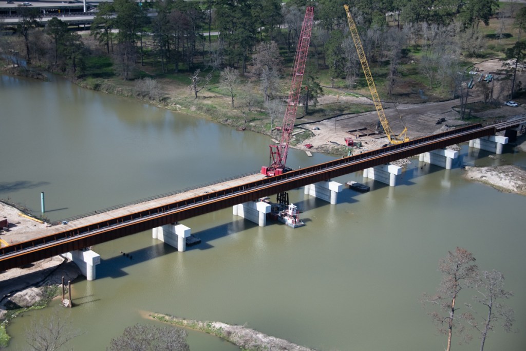
Replacement of the old Union Pacific Bridge across the San Jacinto West Fork is nearing completion.
Less than a month ago, crews constructing the new railroad bridge still had to remove the supports for the old bridge. See below the old four-post steel-frame structures between the new cement supports.
Photo taken on January 20, 2020 shows old supports still in place between new concrete supports.
By 2/13/2020, however, only one of the old supports remained. See photo below.
Photo taken on 2/13/2020 shows only one of the old supports remains.
Trees caught in Union Pacific Railroad Bridge supports during Hurricane Harvey.
The result: the tracks were destroyed. UP had to reroute northbound rail traffic out of Houston for months as they literally built a new bridge around the old one.
Harvey knocked out the Union Pacific Railroad bridge over the San Jacinto River near I-69.
The concrete supports for the new bridge are spaced much farther apart. Thus, they should allow trees to pass through in a flood and eliminate backwater effects.
Photo taken 2/13/2020, the same time as the first shot above. This is from the other side of the bridge.
Other Sign Job is Nearing Completion
Notice in the picture above that crews have already started removing the temporary bridge for cranes on the north side of the river.
All of this is good news from flood remediation and mitigation perspectives. It is yet one more sign that life is finally starting to return to normal after Harvey. The bridge should also help the community deal better with the next major storm.
Posted by Bob Rehak on 2/17/2020
902 Days since Hurricane Harvey
https://i0.wp.com/reduceflooding.com/wp-content/uploads/2020/02/20200213-RJR_7956.jpg?fit=1200%2C800&ssl=18001200adminadmin2020-02-16 19:46:332020-02-16 19:46:51Union Pacific Almost Done Removing Last Remnants of Old Railroad Bridge