A flyover of the lower portion of Ben’s Branch on March 6, 2020, revealed that Harris County Flood Control has nearly restored its conveyance, even if some sediment still needs to be hauled off.
With most of lower Ben’s Branch cleaned out, the Kingwood Library (left), Kingwood Greens (right), and The Enclave (background) can now breathe much easier.
Among Hardest Hit Areas During Harvey
During Hurricane Harvey, some of the hardest hit areas in Kingwood bordered Ben’s Branch. Ben’s Branch cuts diagonally through Kingwood from St. Martha Catholic Church on the north to Town Center, Kingwood Greens, The Enclave, Kingwood Village Estates and Kings Harbor on the south. Post-Harvey surveys showed significant sediment buildup along the creek which reduced conveyance.
The project scoped by HCFCD is to remove approximately 80,000 cubic yards of sediment between the red line at Kingwood Drive and the YMCA at the bottom right of the circle.
Flood Control estimated they would need to remove 75,000 to 80,000 cubic yards to restore the conveyance. Despite a setback called Tropical Storm Imelda, the project has been moving along nicely.
Looking west from the West Lake Houston Parkway Bridge at Ben’s Branch before the project started.To get a sense of scale, that’s a HCFCD surveyor in the yellow jacket!The same area today (looking west from a helicopter over the WLHP Bridge (lower left).
Here’s how the rest of the project looks.
East of the WLHP Bridge (foreground), some sediment is still drying along the banks before removal.However, the channel is openagain for business.The long stretch behind the Kingwood Town Center Apartments has been restored.The stretch just south of Kingwood Drive by ReMax still needs clean-out and touch up.The area just east of the YMCA is still being actively excavated.Same area, still being actively excavated near YMCA.
Merchants and residents alike should breathe much easier during the upcoming hurricane season.
Posted by Bob Rehak on 3/10/2020
924 Days after Hurricane Harvey
https://i0.wp.com/reduceflooding.com/wp-content/uploads/2020/03/20200306-RJR_9648.jpg?fit=1200%2C800&ssl=18001200adminadmin2020-03-10 08:06:022020-03-10 12:36:35Conveyance of Lower Ben’s Branch Nearly Restored
Greek food lovers in Kingwood received a small, but welcome sign of recovery this week – the community’s first Greek restaurant. It’s called Taste of Greek. And it opened in the shopping center next to the CVS pharmacy on the southeast corner of West Lake Houston Parkway and Kingwood Drive.
While the decor is modest, the taste is big.
Taste of Greek Grand Opening
Taste of Greek operated out of a food truck on North Park Drive for several years. I loved their food. But honestly, it was difficult to enjoy when the temperature climbed over a hundred in the shade.
I’ve been hooked on Greek food since going to college in Chicago. There’s a huge Greek community there. And I used to make regular pilgrimages down to Halsted Street for some of the best Greek food this side of the Atlantic. While Greek is not impossible to find in Houston, it takes some driving.
Family-Run and FRESH!
Now here’s the thing if you’re a gyros and baklava kind of person.
Taste of Greek beats every other Greek restaurant in Houston hands down. And it’s on a par with some of the best Greek food in Chicago.
The menu is not very lengthy and you find tablecloths, but OMG, is the food fresh! The pastries are better than “to die for.” They’re “to live for.”
Taste of Greek is a small family-run restaurant. The parents work the kitchen while the daughters serve and work the counter. They opened this weekend. My wife and I have eaten there TWICE so far. It’s that good.
An added bonus: seeing the pride in the eyes of a family that just graduated from operating a food truck to being the proprietors of a sit down restaurant.
Stop by and give them a try. If you like Greek food at all, I highly recommend it. Taste of Greek is guaranteed to take your mind off flood control.
Posted by Bob Rehak on March 9, 2020
723 Days since Hurricane Harvey
https://i0.wp.com/reduceflooding.com/wp-content/uploads/2020/03/Taste-of-Greek.jpg?fit=1299%2C1782&ssl=117821299adminadmin2020-03-09 19:22:202020-03-09 20:14:33Small, But Welcome Sign of Recovery: Taste of Greek
Since Hurricane Harvey, KSA has worked diligently to restore the damage to River Grove Park. It has been a massive job. Harvey filled in the lagoon in front of the boardwalk; left five feet of sand in the parking lot, disc golf course, and playing fields; and deposited a sand bar more than a quarter mile long and 12 feet high in front of the boat dock.
River Grove Waterfront on 9/14/2017, two weeks after Harvey. Lagoon filled in, five feet of sand filled the parking lot, and a 1400-foot, 12-foot-high sandbar blocked off the drainage ditch that empties the western third of Kingwood.
Army Corps Restored River Access
The Army Corps cut a channel through the sand bar that blocked the drainage ditch that empties the western third of Kingwood. That was a huge sigh of relief for a large part of Kingwood. But much work remained to restore the park itself. Among the last items on the agenda: restoring the lagoon and boat ramp access.
It’s hard to capture the scope of dredging operations from the ground – especially with access restricted for safety reasons. But last week, I did a flyover and captured these pics from a helicopter.
Looking west toward the River Grove Boat Ramp and Lagoon. Photo taken March 5, 2020. The dredge started by the boat dock and is working upstream now in the lagoon. Note the dewatering plant in the parking lot and the growing pile of spoils waiting for removal on the right.
In the photo above, you can see the 50-foot strip where Kayden removed vegetation. That will be the limit of dredging. KSA plans to remove 4-5 feet of sand from this area. The area still covered with grasses will remain wetlands. It will provide cover, habitat and food for birds and other species. That should help make River Grove a destination for birders again.
Harvey deposited sand several feet deep on the peninsula that defines the River Grove lagoon. That unfortunately killed many of the trees there. The wetlands remaining in the lagoon are now more important than ever. Eagles nest in the trees in the upper right of this photo on Romerica property.The dredge started in the area in front of the boat dock and is working its way upstream in the lagoon. Water from the dredge goes through a floating pipe to a dewatering plant in the parking lot. Water is then returned to the lake in a closed-loop process.
A Bit of the Oil Field Comes to River Grove
The dewatering plant separates sand and sediment from the water before returning the water to the river.This is the same type of equipment used in oilfields to separate drilling cuttings from drilling mud, before recycling the mud.
Expected Finish By End of March
KSA expects the dredging project to finish by the end of March, weather permitting. However, the boat ramp may not open immediately. The heavy equipment has damaged the asphalt in the parking lot. Repairs and restriping may take a few weeks more.
Originally, KSA expected to remove 10,000 cubic yards of sediment. The contractor now predicts they will remove 11,000 to12,000 cubic yards to complete the scope of work.
Other Park Improvements
The good news: When all of this is done, River Grove Park should be back and better than ever. During repairs, KSA decided to:
Convert several of the soccer fields from “league fields” to “public fields.” Residents have long requested that change.
Change the speed bumps to milder speed humps in the traffic circle. Boaters have long requested that.
Posted by Bob Rehak on 3/9/2020
923 Days since Hurricane Harvey
https://i0.wp.com/reduceflooding.com/wp-content/uploads/2020/03/20200306-RJR_9605.jpg?fit=1200%2C800&ssl=18001200adminadmin2020-03-09 15:54:072020-03-09 15:57:09New Aerial Photos of River Grove Park Show Extent of Dredging Project
Fourteen documents filed with the Harris County District Clerk’s office on February 27, 2020, lay out the case of plaintiffs in the Elm Grove flooding case against LJA Engineering, Inc. Lawyers for the plaintiffs named LJA as an additional defendant in their most recent amended petition. Other defendants include Perry Homes’ subsidiaries and contractors: Figure Four Partners, LTD.; PSWA, Inc.; Rebel Contractors, Inc. (which recently changed its name); Double Oak Construction Inc.; and Texasite LLC.
Accusations Specific to LJA
The amended petition alleges LJA:
a. Failed to follow the correct drainage guidelines in Montgomery County;
b. Failed to provide adequate drainage in the Development;
c. Failed to adequately model the Development;
d. Failed to adequately report the modeling;
e. Removed drainage channels;
f. Caused post-development discharges and water surface elevation to increase downstream of the Development;
g. Failed to design detention ponds with adequate capabilities for rain events;
h. Failed to use the correct hydrology method;
i. Failed to design emergency overflows for the detention ponds;
j. Failed to notify the Developer Defendants and Contractor Defendants of the importance of the existing levee; and,
k. May be liable in other ways described in the consulting engineer’s report.
Consulting Engineer Says LJA Used Outdated Drainage Criteria Manual
The defendants’ consulting engineer, L. David Givler, MSCE, PE, provides the details that back up these claims. Givler is president of Givler Engineering, Inc. Givler’s firm is licensed in Texas to design drainage projects similar to Woodridge Village, which was designed by LJA. A “Certificate of Merit” filed with the court states Givler’s credentials and conclusions. Givler also provides thirteen more exhibits as part of his affidavit. (See links at bottom of post.)
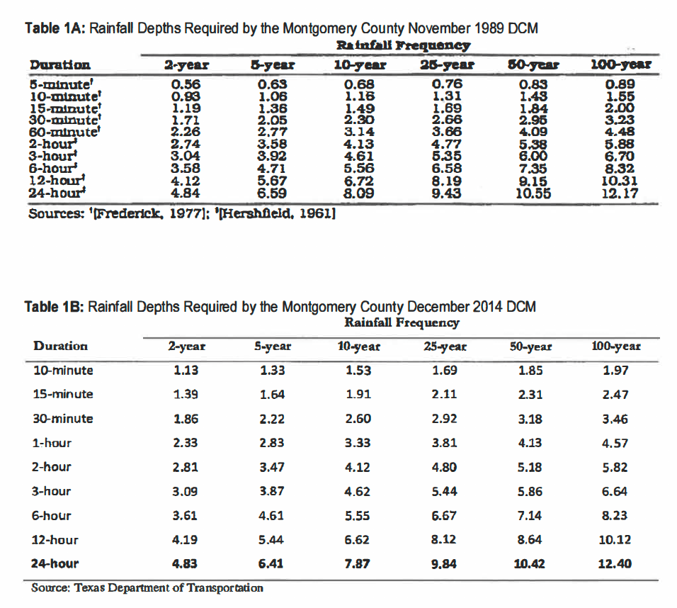
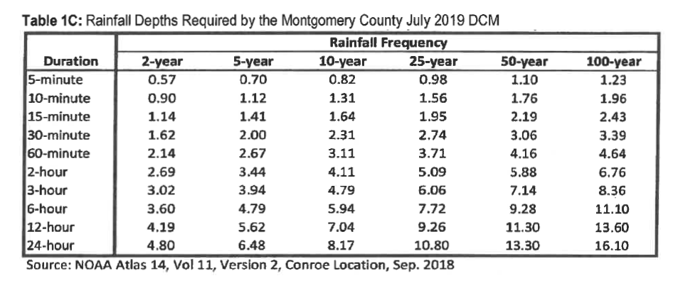
Perhaps Givler’s most explosive finding: LJA based all of its conclusions on an outdated version of the Montgomery County Drainage Criteria Manual (DCM) developed in 1989. MoCo has since updated its DCM twice – in December 2014 and July 2019. Givler asserts that LJA should have used the 2014 version when it submitted its drainage analysis in 2018. The rainfall that MoCo requires engineering firms to design detention basins for have increased since 1989 (see below).
Givler asserts that the increases, along with other other errors and omissions outlined below critically skew modeling results. Ponds that might not overflow based on the 1989 rainfall depths do overflow with 2014 and 2019 rainfall statistics.
Critical Levee Removed, But LJA Did Not Model Effect of That
Givler says in his testimony that grading associated with the construction project removed a levee that had been constructed along the south side of Taylor Gully. “Prior to being removed, the levee had successfully protected the Elm Grove Village Subdivision from flooding,” said Givler. “However, removal of the levee increased the probability for Taylor Gully to overflow southward and to flood the Elm Grove Village Subdivision.”
Givler asserts that the levee successfully protected Elm Grove from flooding in previous extreme events such as Hurricane Harvey, which he characterized as a 330-year storm.
LJA Did Not Use MoCo’s Recommended Method For Modeling Runoff
Mr. Givler also found that LJA did not use Montgomery County’s recommended method for modeling runoff. LJA used something called the Clark’s Unit Hydrograph Method instead of the NRCS Hydrograph Method specified in the 2014 version of the County’s Drainage Criteria Manual. The latter shows significantly higher peak runoff rates, according to Givler. “LJA’s selection of an alternative method (The Clark Method) caused the underestimation of peak runoff rates,” said Givler. “LJA also used low, outdated rainfall depths in its model, which exacerbated the underestimating of the peak runoff rates.”
Givler modeled whether LJA’s designs for the Woodridge Detention Ponds would have successfully held the runoff from the updated drainage criteria manual.
He found that the design for the ponds was “inadequate.” They overflowed. Significantly, Givler also found that LJA underestimated the volume of runoff sent downstream to Taylor Gully.
After May, Protection Not Implemented Against September Storm
“Even after the May 2019 flood, adequate measures had not been implemented to restore the pre-development level of protection or to prevent a recurrence,” said Givler. “Under Woodrige Village pre-development conditions, the Elm Grove Village subdivision was safe from flooding during the 330-year Hurricane Harvey rainfall. However, under construction conditions at Woodrige Village, Elm Grove Village was vulnerable to flooding in the 19-year and 92-year rainfall events.”
LJA Did Not Model Effect of Overflow Channel
Givler also noted that LJA’s plan claimed that the 100-year peak stage for the S2 detention pond would be 73.21. That would be high enough to cause water to backup into the grass-lined channel (bottom elevation 68.50) located at the northeast corner of the pond. “Since the highest adjoining ground elevation south and east of the grass-lined channel is approximately 72,” said Givler, “the peak 100-year stage would discharge to Taylor Gully downstream of the project and to the neighborhood east of pond S-2 [North Kingwood Forest]. Such discharges would increase flooding to the residential lots to the east…”
Figure 4 from Page 12 of Givler’s affidavit shows 100-year runoff overflowing Pond S-2 through the Grass-Lined Channel.The grass-lined overflow spillway in the center of this photo is designed to funnel water from Taylor Gulley into the kite-shaped detention pond (S2) if the concrete channel overflows. But Givler says LJA did not model the opposite. In May and September 2019, water flowed from the gulley into the homes at the bottom left of the frame, as well as homes opposite them on the far side of the gully.
Emergency Overflow System Not Provided
Another problem that Givler found: Section 7.3.13 of the Montgomery County Drainage Criteria Manual (2014 version) requires an emergency overflow system shall be provided “…designed to carry the 100-year allowable detention basin discharge at full-bank conditions… The emergency overflow system shall direct flows into an outfall channel and prevent flow in the direction of developed areas.” (as quoted by Givler).
Even today, the project does not include such an overflow system.
Runoff During Construction More Severe than Ultimate Buildout Conditions
Givler modeled actual construction conditions after the May storm. He found that “…with the project site cleared and stripped of vegetation, runoff conditions were more severe than even the ultimate buildout condition. LJA’s analysis does not address this condition,” he says. His analysis showed that under construction conditions, LJA’s partially-constructed detention ponds were inadequate, unable to contain the May 2019 runoff and the 100-year runoff.”
The temporary construction conditions he says, “caused the ponds to overflow and to discharge runoff to the Elm Grove Village subdivision at a peak rate of approximately 2,110 cubic feet per second.”
Water running through North Kingwood Forest into Elm Grove (background) during Imelda as Keith Stewart evacuates his family.
“LJA Failed to Act as a Reasonably Prudent Engineering Firm”
In his conclusions, Givler alleges that “LJA failed to act as a reasonably prudent engineering firm.” He added, “…three professional engineers and the engineering firm were negligent in the provision of professional services that they rendered, and they committed various actions, errors, or omissions in providing professional services by violating standards required by Montgomery County.”
In Givler’s opinion, LJA failed to comply with Montgomery County standards by:
a. Using an alternate (Clark) hydrology method rather than the NRCS method recommended by Montgomery County, resulting in the underestimation of the amount of runoff that the watershed would discharge to the detention ponds.
b. Using rainfall depths in the hydrology models which are smaller than what was required by the applicable county standard (2014 DCM) and that are much smaller than recently adopted values (2019 DCM).
c. Designing detention ponds, which are too small to contain and too small to detain or attenuate the 100-year design flood.
d. Failing to design adequate freeboard for the detention ponds.
e. Failing to design adequate emergency overflows for the detention ponds.
f. Designing a project, which diverts runoff to properties of others in a harmful and detrimental manner.
g. Allowing peak runoff discharges downstream of the project to increase due to the impact of the project and due to the limited effectiveness of the detention ponds.
h. Allowing water surface elevations downstream of the project to increase due to the impact of the project and due to the limited effectiveness of the detention ponds.
i. Erroneously representing that the project had no impact on downstream areas.
j. Failing to notify the contractor of the importance of the existing levee.
k. Failing to guide the contractor in a logical construction sequence that would reduce the flood risk during construction.
Violation of Professional Standards and Ethics Also Alleged
Mr. Givler also alleges that LJA and three of its employees violated standards established by the State of Texas and the Texas Board of Professional Engineers in the Texas Engineering Practice Act. “This negligence caused and/or contributed to the endangerment of lives, health, safety, property and welfare of hundreds of people near the project,” he says. They did this, he asserts, “by issuing misleading reports, which failed to indicate the increase in flood potential.”
Questions Remain
“I recognize that additional documents may be produced,” said Givler, “which I will be asked to review and, therefore, reserve the right to add to or to modify this affidavit based on information that may be provided to me at a later time.”
Except for general denials, neither LJA, nor any of the other defendants in this case have responded publicly yet to Givler’s specific allegations.
When LJA and the other defendants make their positions public, I shall review them and give them “equal time.”
The big questions I have at this time are:
Why would a firm with LJA’s substantial reputation make the blunders that Givler asserts? Were they pressured into producing a favorable report that made the economics of the project “work”?
Five previous developers owned this land and, after studying it, decided not to develop it. That certainly should have raised red flags for LJA and Perry, and caused them to review this closely. There must have been scuttlebutt circulating among local professionals. One engineer I consulted said Friendswood walked away from this property decades ago because it would have been too hard to develop. However, Perry decided to move forward based on dubious studies and incomplete data. Why?
Check out the original text of Mr. Givler’s affidavit and exhibits for yourself to ensure I summarized them fairly. His affidavit includes his findings, professional opinions, conclusions and Exhibit 1, his resume.
Exhibit 2 includes the list of documents Givler reviewed in developing his affidavit.
Exhibit 3 includes topographic mapping for construction and pre-construction conditions.
Exhibit 4 includes a topographic map showing the location of the former levee.
Exhibit 5 includes the approval letter by Montgomery County.
Exhibit 6 includes the rainfall values used by LJA.
Exhibit 8 includes reported locations of flooded properties.
Exhibit 9 includes the drainage impact analysis submitted by LJA on March 26, of 2018.
Exhibit 10 includes the drainage impact analysis submitted by LJA on August 28, of 2018.
Exhibit 11 includes Givler’s hydrology model for pre-development conditions.
Exhibit 12 includes Givler’s hydrology model for construction conditions.
Exhibit 13 includes Givler’s hydrology model for post-development conditions.
Exhibit 14 includes LJA’s design for detention pond S2, the one north of Village Springs.
Posted by Bob Rehak on March 8, 2020 based on testimony from David Givler PE
922 Days since Hurricane Harvey and 171 since Imelda
The thoughts expressed in this post represent opinions on matters of public concern and safety. They are protected by the First Amendment of the US Constitution and the Anti-SLAPP Statute of the Great State of Texas.
https://i0.wp.com/reduceflooding.com/wp-content/uploads/2019/10/Stewart-Evac-9.19.19-e1619020734162.jpg?fit=999%2C739&ssl=1739999adminadmin2020-03-08 14:18:022020-03-08 14:18:22Plaintiffs’ Engineer Alleges LJA Issued Misleading Studies, Followed Wrong Guidelines in Elm Grove Flooding Case
The land in Woodridge Village naturally slopes from north to south and west to east. That means it forms a funnel pointed at Taylor Gulley in the southeast portion of the development. During heavy rains, as we saw last May and September, that funnel turns into a water cannon aimed at Elm Grove and North Kingwood Forest. These new aerial photos show where the water is aimed.
Looking toward southeast, you can see how all the land in Woodridge Village slopes toward the far corner.North Kingwood Forest is the group of houses you can see in front of the water tower. Elm Grove is behind those and also the far tree line right of those.
When the land above was wooded and populated only by forest and wetlands, water percolated through the area slowly. Now that the Perry Homes’ gang clearcut the entire 268 acres, water shoots through it like the barrel of a water cannon.
“What Happens If We Cross The Streams?”
LJA Engineers designed the drainage for this development so that virtually all water would converge in the kite-shaped detention pond below before flowing into Taylor Gulley.
Looking west from the southeastern corner of Woodridge Village. North Kingwood Forest is at the bottom of the frame and Elm Grove is tucked into the trees in the upper left and beyond. Virtually all water from the development flows to the pond in the center of this photo. Then it flows through the twin culverts into Taylor Gully on the left.
When the pond fills and water starts to back up, channel starts flowing through the backwards of the homes at the bottom of the photo above.
Looking southwest. Water flows from top to bottom and right to left. Water from Taylor Gulley, the channel that forms a V above, must either squeak through a 3 foot pipe at the end of the concrete section on the left, or make a double U-turn into the detention pond and then back into the gulley on the left.That’s like forcing traffic make a U turn in the center of a busy intersection.
Egon: Don’t cross the streams. Peter: Why? Egon: It would be bad. Peter: I’m fuzzy on the whole good/bad thing. What do you mean “bad”? Egon: Try to imagine all life as you know it stopping instantaneously and every molecule in your body exploding at the speed of light. Raymond: Total protonic reversal. Peter: That’s bad. Okay. Alright, important safety tip, thanks Egon.
Obviously, the LJA Engineers who designed this drainage either didn’t see the movie or didn’t take it seriously.
Dumping Overflow into Surrounding Streets and Homes
In the photo below, you can see where the water goes when the streams cross during heavy rains. The pond and the stream (Taylor Gulley) leading to it become water cannons when they overflow. Water shoots into the homes in North Kingwood Forest (right). It also shoots down the streets of Elm Grove (bottom left).
Looking north up Village Springs Drive toward Woodridge Village. Virtually all water from the development converges in the kite-shaped detention pond. During floods, overflows shoots down Village Springs or into North Kingwood Forest (right).
Below are links to two videos that show water overflowing from the detention pond into Village Springs Drive and the homes there.
Of course, part of the problem with crossing these streams is that Perry Homes still has only installed 23% of the detention. There’s just no way that 23% can do the job of 100%. The rest of that water has to go somewhere else. Like living rooms, kitchens, and bedrooms.
Posted by Bob Rehak on 3/7/2020 with thanks to Dan Aykroyd, Harold Ramis, Alyssa Harris and Edy Cogdill
921 Days since Hurricane Harvey and 170 since Imelda
The thoughts expressed in this post represent opinions on matters of public concern and safety. They are protected by the First Amendment of the US Constitution and the Anti-SLAPP Statute of the Great State of Texas.
https://i0.wp.com/reduceflooding.com/wp-content/uploads/2020/03/20200306-RJR_0180.jpg?fit=1200%2C800&ssl=18001200adminadmin2020-03-07 16:48:322020-03-07 16:48:42Staring Down the Barrel of a 268-Acre Water Cannon
Court documents filed with the Harris County District Clerk show that the tempo of the Elm Grove lawsuits against Perry Homes, its subsidiaries and contractors is increasing. Litigants have filed 20 new documents in the last three weeks. The judge has set a trial date for July 13, 2020. That’s about three months from now.
Plaintiffs allege that LJA, when designing the drainage for Woodridge Village, used an outdated Montgomery County Drainage Criteria Manual. LJA went by the 1989 version when an updated 2014 version existed. Since then, MoCo has revised the documents yet again. A 2019 version now exists that took effect before Imelda last year. (Note: the link above leads to the updated manual, however, MoCo did not update the date on the cover page. So this gets very confusing.)
List of Charges Expands
Plaintiffs’ lawyers have added negligent retention and negligent supervision to the list of charges. They now accuse defendants of:
a. Removing drainage from the Development;
b. Removing a levee from the Development site;
c. Blocking the drainage channels;
d. Filling in existing drainage channels;
e. Failing to properly install box culverts;
f. Failing to create temporary drainage channels;
g. Failing to allow adequate drainage after construction;
h. Failing to install silt barriers;
i. Allowing the Development to force rainfall toward Plaintiffs’ homes;
j. Failing to pay proper attention
Plaintiffs argue that “the Contractor Defendants had actual, subjective awareness of the risk involved, but nevertheless proceeded with conscious indifference to the rights, safety, or welfare of others.”
The streets of Elm Grove are still littered with trash from reconstruction of their homes after Imelda – the second flood in 2019.This image was taken on Village Springs in Februaryof 2020.
Accusations Specific to LJA
The amended petition also lists charges specific to LJA.
a. Failing to follow the correct drainage guidelines in Montgomery County;
b. Failing to provide adequate drainage in the Development;
c. Failing to adequately model the Development;
d. Failing to adequately report the modeling;
e. Removing drainage channels;
f. Causing post-development discharges and water surface elevation to increase downstream of the Development;
g. Failing to design detention ponds with adequate capabilities for rain events;
h. Failing to use the correct hydrology method;
i. Failing to design emergency overflows for the detention ponds;
j. Failing to notify the Developer Defendants and Contractor Defendants of the importance of the existing levee; and,
k. Other ways described the consulting engineer’s report.
Plaintiffs Seek Exemplary Damages and Mandatory Injunction
The plaintiffs now seek exemplary damages and a mandatory injunction that forces defendants to return the property to its prior condition, wherein the surface water runoff properly flows into the drainage ditch.
Defendants also filed the reports of two expert witnesses: an engineer from Pennsylvania, who examined LJA’s performance, and another expert, who will testify about the magnitude of rainfalls on May 7th and September 19th. More on those in a future post.
No Response Yet from Defendants to Specific Charges
We still have yet to see the defendants’ specific responses to any of these charges except for the general denials they made last year.
Posted by Bob Rehak on 3/6/2020
920 Days after Hurricane Harvey and 169 since Imelda
https://i0.wp.com/reduceflooding.com/wp-content/uploads/2020/02/20200125-RJR_7513.jpg?fit=1200%2C800&ssl=18001200adminadmin2020-03-06 17:46:012020-03-08 09:39:48Elm Grove Lawsuits: New Defendant, New Charges, Amended Petition and More
A new web site, MyFloodRisk.org, gathers and presents information in a way that makes it easier than ever to accurately assess flood risks and costs.
One of the nation’s largest insurance companies developed the site after years of watching people fall victim to outdated and inaccurate flood maps. Therefore, the site analyzes data from many other sources to gain a much more complete understanding of risk.
Assesses Flood Risk for Every Property in U.S.
The site collects relevant flood-related information on every property in the United States and organizes it in a powerful way that makes it easy to visualize your flood risk. Just put in an address and boom. You’re scrolling through screen after screen that shows:
Your base flood elevation
Slab elevation
Proximity to flood zones
Total FEMA insurance claims in your county
Total recorded flood events in your county
FEMA disaster assistance grants in your state to date
Potential for storm surge (not really a factor in the Lake Houston area, but important in you have a vacation home further south)
Frequency of tropical storms, and more.
See a few of the screen shots below.
Quickly see what flood zone you are in and the percent of FEMA payouts in that zone.I was shocked to learn that even though I am in an X zone, 20% of all NFIP claims and one-third of all federal disaster assistance comes from an X zone.Based on your address, the site calculates the difference between your slab elevation and the base flood elevation.
Note, even though I’m more than 13 feet above the base flood elevation, during Harvey, the flood came up to my driveway, where first responders were launching rescue boats!
Total FEMA Insurance Claims in Harris County. County will change depending on address.A composite score pops up as last screen in series and lets you download a PDF of entire sequence.
Flood Damage Calculator Estimates Cost Per Inch of Floodwater
Not only is there a flood RISK calculator. The site also contains a flood LOSS calculator. For the latter, you plug in the value of your home and its contents. Then you set the flood height – from one inch to 48″. It calculates how much you could typically expect to lose with a flood of that height.
Potential Flood Loss Calculator. Input values for property and possessions, then use slider on right to see potential losses based on different flood heights.
The scary thing is how much you could lose even you get just an inch of water in your home! Play with it. You will see what I mean.
Free Service, No Purchase Necessary
The web site is affiliated with an insurance company, National Flood Insurance, LLC, which is licensed in all 50 states. I’m sure they will be happy to provide you with a flood insurance quote if you want one, but it’s not necessary to get a quote or talk to an agent to use this free risk and damage assessment service.
Professional Version Available
The site’s manager, Jennifer Scherff, says, “We have a professional version of the website as well that we offer to realtors and lenders. This version is free as well. For professionals we offer liability waivers on our flood risk reports, to bring awareness of true flood risk to the groups of people who are selling homes to unknowing individuals, especially in states where flood disclosure laws do not exist.
“At the end of our wizard tool where you are given a final flood risk score we have a new section that allows the user to answer a few questions and recieve a flood insurance indication quote in seconds. These quotes are the most accurate you’ll find,” claims Scherff.
Without recommending this, or any other broker/agent, I would just say this. If you live in the Lake Houston Area, you should have flood insurance. As we saw last year, river flooding is not the only threat. With the high intensity rains we get here, street flooding is a constant threat, too.
Delivers “The Right Five”
In the information technology business, they have a maxim called “The Right Five.” Success is all about presenting the Right Information to the Right People in the Right Format at the Right Time in the Right Place. This web site scores a check mark on all five.
Re: the Right Time, hurricane season starts June 1. Remember, it takes 30 days for flood insurance to go into effect. So if you think you MIGHT want it, the time to start thinking about it is NOW.
You could find all the information they present by yourself if you were willing to crawl the web for hours. They aggregate everything in seconds and present it in an easy-to-understand, graphically appealing format.
The site also contains tips on flood mitigation, flood restoration, a blog, a reference library and a link to get a quote.
919 Days since Hurricane Harvey and 168 since Imelda
https://i0.wp.com/reduceflooding.com/wp-content/uploads/2020/03/Flood-Loss-Calculator.jpg?fit=1200%2C684&ssl=16841200adminadmin2020-03-05 13:40:022020-03-05 16:30:41New Website Makes It Easier to Accurately Assess Flood Risk, Potential Damage
During the first phase of River Grove dredging, the contractor, Kayden, removed vegetation from the area to be dredged adjacent to the boardwalk (see photo below).
River Grove Boat Ramp and Lagoon on 2/13/2020 before dredging operation started. Looking south.
They completed vegation removal last week. They also completed cleaning silt out from under the boardwalk without impacting its stability or support. This week, they’re back with a tiny dredge and a giant mobile dewatering plant.
The Little Dredge That Could
The dredge was selected because it could maneuver in the tight spaces adjacent to the River Grove Boardwalk. It’s 12 feet wide and 51 feet long. The first word that came to mind when I saw it was “cute.” The second thing that came to mind was the child’s story “The Little Engine that Could.” As it sat there chugging away at sand and silt, I thought I could hear the John Deer, 6-cylinder, 13.5 liter diesel engine chanting, “I think I can, I think I can.”
Dewatering Plant Processes Sand for Removal, Returns Water To River
The giant dewatering plant operates much like shakers used in oil field drilling work. Water and sediment are pumped up from the lagoon by the dredge. They enter one side of the dewatering plant. There, they are pumped through centrifuges, then across a series of screens that vibrate. Water falls through the screens into a tank below. Sand accumulates on the screens until they dump it down chutes. From there, a front end loader scoops up the dirt and piles it up until trucks haul it away.
Video of dewatering plant in operation courtesy of Josh Alberson.Front end loader removes dirt from dewatering plant and piles it up for removal from River Grove.
Kayden then pumps the water back into the river.
Water returned to river after sediment removed. Photo courtesy of Josh Alberson.
Dredge Designed for Tight Spaces
River Grove dredging will not move nearly as fast as the dredging that Great Lakes and Callan were doing, but it seems to work well for the location. A major concern is overly aggressive dredging that could undermine the supports for the boardwalk and boat ramp. Another word that comes to mind is “precise.” Think about the difference between a van and an 18 wheeler. The major issue here is fitting in small spaces.
KSA intends to dredge only 50 feet from the boardwalk instead of all the way over to the trees. This shows the area where vegetation was removed earlier. Dredging will take place within this space.
Despite the size of the equipment at River Grove, the operation itself is far more compact than previous dredging operations. This could form a model for the dredging of inlets around the lake, like the one at Walden. However, County Engineer John Blount emphasizes that no decisions have been made in that regard yet.
The Safety Moment
If you take your kids to River Grove to see this operation, make sure you stay behind the yellow tape for your own safety.
Also, until the operation is complete in another month or so, remember that traffic at River Grove will be two-way. Just be aware.
Posted by Bob Rehak on 3/4/2020 with photos and video from Josh Alberson
918 Days after Hurricane Harvey
https://i0.wp.com/reduceflooding.com/wp-content/uploads/2020/03/20200304-RJR_8795.jpg?fit=1200%2C800&ssl=18001200adminadmin2020-03-04 16:56:292020-03-05 09:27:23River Grove Dredging Operation Moves to Next Phase
We step on them. Spit on them. Park on them. Ride on them. But we rarely think about them. If there’s anything we truly take for granted, it’s the lowly storm sewer inlet.
Critical Rate-Limiting Factor in Drainage
I’ve always known they were there. But I never realized how important they were until I posted about street flooding last week, omitted them, and an expert called them to my attention. Unless properly sized or designed, they can limit how quickly streets drain in heavy rains.
Think of storm sewer inlets like fire exits. Better have enough capacity in the right locations when you need it!
How tall is your inlet?
How wide is it?
Does it have a grate or a plate in it?
Or is it just a hole in the concrete between the street and the curb?
What is the slope of the street towards it?
Can it capture all the water that runs toward it?
Or does some get by?
What’s the spacing between inlets?
Have you ever really thought about these things? Who on earth does?!!!
Visual Inventory of Drain Types
Fortunately, engineers DO. And standards constantly evolve as they come up with better designs. Here are a few variations I spotted as I drove around.
Rectangular grate design in North Woodland Hills.Five inches high.Five feet wide.Steel plate design in Bear Branch. Also five feet wide.Also five inches tall.All concrete version in Sugar Land. Five feet wide……but 7.5 inches tall. That’s 50% more surge capacity than a 5-inch high inlet.
Inlet Trivia
In researching this topic, I discovered many fascinating pieces of trivia.
Thirty years ago, Sugar Land decided to enlarge all its storm sewer inlets. Street flooding is very rare there, almost unheard of.
Storm sewer inlet size and design varies by the type of street.
Thoroughfares usually get bigger inlets than feeders.
Feeders usually get bigger inlets than residential streets.
Hills and busy intersections often get special attention.
Double-wide inlet at the bottom of Kingsway Court by Kingwood High School. Below hillwith approximate 10% grade at end of cul de sac. Better not let the water get by this one!.
Many municipalities (including Houston) frown on grates. While they theoretically offer higher capture rates, they also clog easily and require constant maintenance, increasing costs.
The slope of the street (from the highest point of the crown to the lowest point of the gutter) can radically affect the capture rate of water flowing down the gutter. The slope “forces” the water into the inlet.
The geometry of grates can also radically affect capture efficiency (measured as percent of water intercepted). Below is a video by the U.S. Department of Transportation that shows the efficiency of different geometries for grate designs in a table-top experiment. (Attention science teachers: this is a “must see” video that will fascinate students and could even intrigue some enough to pursue careers in engineering.)
Produced by US Department of Transportation
City of Houston and Other Resources
For those who want to learn even more, here is a link to the current City of Houston infrastructure design standards for stormwater runoff. Page 139 shows you how much the capacity of inlet types can vary. Some inlets can handle four times more cubic feet per second than others.
When looking for a new home, storm sewer inlets may be the last thing you think about. But just like plumbing, maybe they should be one of the first.
Posted by Bob Rehak on 3/3/2020
917 Days after Hurricane Harvey and 166 after Imelda
https://i0.wp.com/reduceflooding.com/wp-content/uploads/2020/03/20200229-RJR_8776.jpg?fit=1200%2C800&ssl=18001200adminadmin2020-03-03 19:22:342020-03-04 09:59:02Storm Sewer Inlets: Often Overlooked in Cases of Street Flooding
Randy Reagan is tough. He grew up in the Conroe oil fields and riding bulls. But nothing prepared him for flooding five times in four years and the series of events that followed.
Reagan raised his family on a 5-acre lot in Bennett Estates. That’s a neighborhood between the San Jacinto West Fork and FM1314, just south of SH242. He made a modest living for himself as an oil-field technician by repairing turbines, first for a local company and then for GE. He harvested all the meat his family ate from his own property and the surrounding forests. Life was good.
Built Home Above 1994 High Water Mark
Bennett Estates rises up from the banks of the San Jacinto West Fork through the 100- and 500-year flood plains to even higher ground. Reagan’s slab is a foot above the high-water mark from the 1994 flood, which at the time involved a massive release from the Lake Conroe dam. So he figured he was safe for anything the future brought. Wrong!
Reagan lives between the sand mines east of the river, just above the mine at the bottom, in the aqua-colored 100-year flood plain. Source: FEMA.
A Happy Life, Until…
While Reagan was never destined for riches, he led a happy life. Until the sand mines came. Then everything changed.
Reagan now lives in a neighborhood five blocks deep – sandwiched between three sand mines comprising almost 1500 acres.
Despite being in the 100-year flood plain, his property has only flooded twice from the San Jacinto – in 1994 and 2017 during Harvey. However, in the last four years, he says, it has also flooded four times from sand mines – twice in 2016, once in 2018 and once in 2019 during Imelda.
As the sand mines have grown, they’ve removed forests and wetlands that used to slow water down during rainfalls.
Now the water rushes through sand pits largely unimpeded. While the mines like to tout how they offer detention capacity in storms, aerial photos show that they offer little. That’s because they are often filled to the brim…even before storms. So, it doesn’t take much to make them overflow in heavy rains.
Water flows down into the mines from higher ground and quickly fills the pits. The pits can then spill over into the river and surrounding neighborhoods.
LMI Pit to the North Sends Water South into Neighborhood
That’s what Reagan contends happened with the LMI pit to the north of him.
During Harvey, a satellite photo in Google Earth shows the water blew out the mine’s perimeter road, sending water gushing into Reagan’s neighborhood.
During other recent events, Reagan has ground-level photos that show silty, sandy-brown water coming from the direction of the mine, not the river.
LMI breach into Reagan neighborhood on 8/30/2017 during Harvey.Five HVL pipelines are now trying to repair damage caused when this mine mined too close to them.The LMI mine to the north of Reagan on Feb. 13, 2020. In heavy rains, there’s little to keep water from the mine from escaping into Reagan’s neighborhood out of frame at the bottom of the photo.Photo taken in moderate drought conditions.
Hanson Pit to South Backs Water Up into Neighborhood
The mine to the south of Reagan affects him in a different way. Twice, says Reagan, the mine has built walls that blocked the flow of ephemeral streams that used to run through his neighborhood.
The mine dug a ditch to the river in 2011 to let the water drain to the river. That worked for about five years. Then the ditch became overgrown and the volume of water coming from the northern mine became too much. Reagan flooded on Tax Day and Memorial Day in 2016, 2018, and Imelda in 2019. Not to mention the 93 inches he got during Harvey in 2017.
Dirt wall erected by Hanson Aggregates between their pond and Reagan’s property. The drainage ditch in the foreground that they dug in 2011 is no longer any match for water flowing south from the LMI mine behind the camera position.
Problems Grow as Sand Mines Grow
“The sand mines have destroyed our lives,” said Reagan. “We’ve lived here all our lives. This all used to be woods for acres and acres and acres. The first problem I had was back in the 90’s when the sand pits were getting bigger.”
“As they started developing more ponds, they started interrupting the natural runoff.”
Randy Reagan
“When we moved here in the late ’90’s, we had our homesite raised four feet. That’s where FEMA drew the line for insurance at the time. We figured if we built higher than the high water mark from 1994, we would never have to worry. Because in 1994, we had Lake Conroe releasing all that water on us.”
“There was another flood in 1998, but it never affected us. We were high and dry here. LMI still had not built the mine to the north of us at that point,” said Reagan.
“Now we’ve got water coming at us up from the river, downhill from one mine and backing up from another mine. Sand from the mines even blocks the street drains that lead to the river,” said Reagan.
“All this used to be woods back here with natural creeks and natural drainage. It’s just all gone now. These sand pits done tore it out,” said Reagan. “They’re like giant lakes with no water control.”
Memorial Day Flood in 2016 invades Reagan’s shop.Memorial Day Flood in 2016 nearly invades Reagan’s home. Note color of water.93″ of floodwater took this home in Harveyone year later.
“In 2016, we got a lot of rain, but the river never got out of its banks much,” he continued. “The people that live next to LMI (on the north) tell me that the LMI walls keep breaking. The water rushes through their property, coming from the sand pit. In 2016, we had milky brown, silty water sweeping through here. It was so swift that it almost took my truck off the road. I got about 20 inches in my garage during Tax Day and Memorial Day storms. But it never got in my home at that point.”
“The Tax Day Flood in 2016 was our wedding anniversary. We tried to celebrate our anniversary while our garage got flooded. That was LMI. And then we got flooded again on Memorial Day. That was LMI,” said Reagan. “In 2016, the river here was NOT out of its banks. We got flooded from the sand pits.”
“Then came Harvey. We might have been fine if all we got was the rainwater. It came close. But then they opened the gates at Lake Conroe. And the sand mine upstream of us broke loose again.
Floods Cause Cascading Series of Problems
“Not only did we lose our house, I lost my job and I lost my health. We really hit bottom.”
“I’ve got breathing problems,” says Reagan. “Everybody in our family has breathing problems.”
“I was still trying to recover from Harvey, the day I lost my job in 2018. I was admitted into the emergency room because of my breathing that same day.”
“In the meantime, we were living in a used camper. And it caught on fire. We didn’t have insurance on it,” said Reagan. “My mother had just died. So we were going through that grieving process. Then the camper burns!”
Never-Ending Noise and Vacant Homes
“It used to be quiet here,” he says. “The sand trucks used to run during the days, but never on weekends and never at night. Now they run 24/7 it seems.”
The sand mines and floods took more than Reagan’s health and home. When long-time residents fled to higher ground, they left behind vacant houses. He worries about a criminal element coming in now.
During Harvey, Reagan says water reached 93 inches in his shop. That’s above the door frame.
Reagan yard during Imelda. Note color of water…again.
“We’re living in my shop now. Everything we have left is in there.”
Posted by Bob Rehak on 3/3/2020
917 Days since Hurricane Harvey and 166 since Imelda
The thoughts expressed in this post represent opinions on matters of public concern and safety. They are protected by the First Amendment of the US Constitution and the Anti-SLAPP Statute of the Great State of Texas.