Here’s a construction update for Perry Homes’ Woodridge Village, the stalled development implicated in flooding Elm Grove and North Kingwood Forest twice last year.
On January 25, 2020, I flew over Woodridge Village. Not much had changed since my December flyover. However, Perry Homes, had concreted about 280 feet of Taylor Gully on the east side of the development facing North Kingwood Forest. And they started to build a berm between Woodridge Village and Elm Grove. Finally, they have started prep work for building more streets. See images below.
Overview of Construction Activity
Homes in North Kingwood Forest (bottom right) flooded twice in 2019 when water from the Taylor Gulley channel behind them overflowed.In December and January, Perry Homes, the ultimate developer of clearcut area called Woodridge Village, lined a portion of that channel with concrete.Closer View: Perry Homes also erected a berm along the southern edge of the kite-shaped S2 detention pond. Note the lack of activity above the pond.
Slanting Berm Between Elm Grove and Woodridge
Since the January flyover, Perry Homes has continued to build up a berm south of the S2 detention pond. The height of the berm is about 3-4 feet immediately west of Taylor Gulley (grassy channel in lower right). It tapers down to nothing before you get to Fair Grove Drive, one long block to the west (out of frame to the left in picture above).
Note height of berm at end of Village Springs Drive, adjacent to Taylor Gulley.Erosion from berm is already starting to collapse silt fence in numerous areas.Photo taken 2/8/2020.Looking east from opposite end of pond. At Fair Grove Drive, the berm is below the level of Elm Grove homes behind the tree line on the right.Photo taken 2/8/2020.
Whether Perry intends to build up the western portion of the berm is unclear. If they intend to go west beyond the point above and continue the berm south of the S1 pond, they have not yet done so.
The Strange Case of the Elevated Swale
Perry Homes has now dug a ditch at the peak of the berm to act as a backslope interceptor swale. Such a swale is designed to reduce erosion on the slopes of a detention pond by channeling water through pipes instead (note concrete opening of one such pipe in distance).Photo taken 2/8/2020.
Originally, I thought the berm might be the missing maintenance road that Montgomery County regulations specify around detention ponds. However, yesterday, Perry Homes’ contractor etched a ditch in the middle of the berm. I guess this ditch will act as the backslope interceptor swale, another requirement of detention ponds in Montgomery County.
Such swales channel water into ponds through pipes installed at low points. Their purpose: to prevent runoff from surrounding areas from flowing over the edge of ditches and causing erosion.
Except in this case, water from the surrounding areas would have to flow uphill several feet to get to the swale. So the swale will only channel water that falls directly on it.
No New Detention Ponds
No new detention ponds have been created since last August.
Prep Work for New Streets
However, Perry Homes is starting to add new storm drains to areas where roads have not yet reached on the north side of the S2 detention pond.
Storm drains being added to the north side of the S2 detention pond. Photo taken 2/8/2020.Note rilling (erosion) along side of pond.
Perry Had Promised No New Streets Until All Detention Ponds In
Point #1 in Perry Homes’ letter to the City Attorney about remediation efforts promised that Perry would delay additional street construction until three detention ponds on the northern part of Woodridge Village were complete. But as you can see from the first photo above, no additional detention ponds have even been started on the northern portion of the site.
Possible Impact of Changes on Flooding
The concrete channel will reduce erosion, but will do nothing to reduce flooding. As you can see from the video below, taken by Jeff Miller after a minor rain, Perry Homes needs the three additional detention ponds they promised in 2017, two and a half years ago, to reduce flooding.
The berm may redirect flooding. The berm has the potential to change the location of flooding. As floodwaters build up in the S2 pond shown above, they will eventually rise above the overflow channel between the concrete portion of Taylor Gulley and the pond. When that happens, the water will go around the berm. It could happen on two sides. On the west at Fair Grove (above) and on the east at Taylor Gulley (below).
Video by Jeff Miller after light rain on Jan. 28th shows flow from north side of Woodridge Village into Taylor Gulley. There should be a massive detention pond beyond the black fence.Taylor Gully concrete channel is approximately one-third fullon about a third of an inch of rain before this point in the day.See graph below. Photo taken around 5pm.The closest official gage at West Lake Houston Parkway showed 0.32 inches of rain before Miller took the photo above.
On the east side of the concrete portion of Taylor Gulley, notice how the edge slants down toward North Kingwood Forest (out of frame on the right).
Note levels on either side of the concrete culvert shown in aerial photos above. S2 detention pond is out of frame to left and North Kingwood Forest to right.Photo taken 2/8/2020.
Once floodwater gets into North Kingwood Forest, experience has shown that it will flow through streets into Elm Grove, bypassing Taylor Gulley.
Storm sewers, once connected to the detention ponds, will simply shorten the time of accumulation after heavy rains and fill the ponds even faster. That usually results in higher peaks. Again, without additional detention, there is no flood-reduction benefit for downstream residents.
Posted by Bob Rehak with help from Jeff Miller on 2/9/2020
894 Days after Hurricane Harvey and 143 after Imelda
The thoughts expressed in this post represent opinions on matters of public concern and safety. They are protected by the First Amendment of the US Constitution and the Anti-SLAPP Statute of the Great State of Texas.
https://i0.wp.com/reduceflooding.com/wp-content/uploads/2020/02/20200208-RJR_7558.jpg?fit=1200%2C800&ssl=18001200adminadmin2020-02-09 14:30:152020-02-10 06:47:08Construction Update: Perry Homes Adding Storm Sewers, Berm to Woodridge Village
Students in grades 8 – 11 can apply to join the national Youth Preparedness Council between until March 8, 2020.
US59 during Harvey. Photo taken from Sorters-McClellan overpass. Courtesy of Melinda Ray.
Purpose of Youth Preparedness Council
FEMA created the Youth Preparedness Council (YPC) in 2012. Its purpose: to bring together young leaders interested in supporting disaster preparedness. They make a difference by completing national and local preparedness projects. The YPC supports FEMA’s commitment to involve America’s youth in preparedness-related activities. Additionally, it lets young people share their perspectives, feedback, and opinions with FEMA .
Includes Representatives from All Ten FEMA Regions
YPC members represent all ten FEMA regions. They have a wide range of backgrounds and interests. Members have been leaders in their communities’ preparedness. They work in teams on projects relating to financial preparedness, citizen responder programs, and youth preparedness education.
Eligibility and Application Requirements
YPC applications remain open through March 8, 2020!
Students in eighth through eleventh grade are eligible to apply.
FEMA emphasizes that being selected to serve is an honor, but also a significant responsibility. The YPC requires dedication and time-management skills.
YPC members serve TWO years. Each YPC year begins in July with the YPC Summit. If members have not completed the mandatory requirements during their first year, FEMA may excuse the member from participating in a second year.
Members serve on committees with assigned tasks. They primarily communicate via email but have bi-monthly conference calls and other calls as needed.
For a full list of Roles and Responsibilities, CLICK HERE.
YPC Summit Held in Washington, DC on July 21 and 22
A YPC Summit is held annually in Washington, DC. In 2020, it will take place on July 21 and 22. Attendance is mandatory for all YPC members. The YPC Summit provides an opportunity for YPC members to meet FEMA representatives and each other.
Sessions during the YPC Summit cover a range of topics. In some sessions, YPC members are given the opportunity to share their ideas and questions with FEMA and community partners. In other sessions, members prepare for the projects they will complete during their time on the YPC.
Travel Expenses Covered for Member and Guardian
Each YPC member must have a parent/guardian or parent- approved chaperone to accompany him or her to the YPC Summit. In accordance with federal travel regulations, FEMA will reimburse transportation, lodging, and meals for each YPC member and his or her parent/guardian/chaperone.
Posted by Bob Rehak on 2/9/2020 with thanks to Congressman Dan Crenshawand photo courtesy of Melinda Ray
894 Days after Hurricane Harvey and 143 after Imelda
https://i0.wp.com/reduceflooding.com/wp-content/uploads/2020/01/Melinda-Ray-Harvey.jpg?fit=900%2C1200&ssl=11200900adminadmin2020-02-09 11:30:442020-02-09 11:30:54FEMA Taking Applications for Youth Preparedness Council
Three generations of the Giles family live together under the same roof in Elm Grove. Jerry Happ, Catrina Giles father, and Evonne Happ, plus Catrina’s children CJ, Dallas and Maverick. They had never flooded, not even in Harvey, until Perry Homes clear-cut 268 acres a block north of them without installing promised detention ponds. Then on May 7th and September 19th of 2019, they flooded twice. This is the story of how those floods affected a family and tore a neighborhood apart. As I drive up to their home on Shady Garden Drive for the interview, the first thing I noticed is that the foundation of their home is raised well above street level. In fact, it appears to be level with the top of my Chevy Tahoe. This is not an isolated case of a low-lying home.
Water Flows Down Street from Direction of Woodridge Village
Rehak: You said you wanted to make sure that Perry Homes knew about the damage that they inflicted on your community. Tell me what happened on May 7. Let’s start there. Where was the water coming from?
View from Giles front porch during Imelda
CJ (Catrina’s Oldest Son): It started off in the garage and my grandparents’ bedroom, which are on the north side of the house. Then it came in the back door and under the kitchen cabinets. And then it was just everywhere.
Rehak: It came in from the north? (The direction of Perry Homes’ development)
CJ: Yes.
Rehak: How high did it eventually get?
C. Giles: (Pointing to an electrical plug) Just under the outlets.
Gasoline, Paint, Paint Thinner Mixed with Floodwaters
Rehak: Tell me about the damage it caused.
CJ: We had a lot of personal items in boxes in the garage. It completely destroyed everything under two feet. All our tools got really messed up. There were a lot of things floating around in the garage. Paint. Gasoline. Paint thinner was mixed in with the water. So, it was a pretty big mess.
J. Happ: It came in, like CJ said, from the north. We had a bedroom set downstairs here…
E. Happ: My sister gave it to us before she passed away. Now it’s gone.
Current Felt Inside the House
J. Happ: The water was so powerful! The pressure of the water was so intense that it caused boxes underneath the bed to move around.
E. Happ: It broke my grandmother’s dishes that we stored under there!
CJ: We had an entire tote filled with family pictures. The lid popped off from hitting the sides so hard. The pictures are all gone now.
Family Heirlooms Destroyed
Rehak: You talked about your grandmother’s china. How old would that have been?
E. Happ: I’m 62. (pausing to calculate then giving up) It was old. They don’t make that kind of crystal anymore.
J. Happ: It was very old. Maybe late 1800’s.
E. Happ: And my bedroom furniture. I mean, no amount of money could ever replace that.
J. Happ: So, it was very devastating. A lot of personal items were in that room, and in the garage being stored at the time. They’re all gone now.
Rehak: I’m curious. You say the water pressure moved things around. It almost sounds like there was a current.
J. Happ: Oh, absolutely. Yes.
C. Giles: Everything in the lower cabinets was all destroyed.
It wasn’t, you know, water just coming in and oozing up. There was a current. Stuff was moving, even inside the cabinets.
Catrina Giles
Swing Set Picked Up by Flood and Moved
E. Happ: See that swing set back there by the big tree? The current picked it up and moved it against the shed.
Force of flood moved swing set and slide against shed (right)
J. Happ: When that water started coming in, we did the best we could. But we couldn’t move things fast enough. All of the furniture and appliances downstairs got damaged and had to be thrown out.
May flood took entire kitchen including appliances, plus washer/drier in utility room.
Refuse to Evacuate to Save Seven Animals
C. Giles: They asked us if we wanted to evacuate. Thank God we had the upstairs. Because they would only allow us to take one animal. And at the time we had seven.
We all have post traumatic stress now.
Evonne Happ
C. Giles: Yeah, It even affected our animals. They all lost weight. And two of them have died. One died shortly after the first flood from a snake bite. And the other just died from the stress. She had undergone her annual checkup, but her body just gave up at Christmas. We had to put her to sleep.
E. Happ: My dog’s scared to go out when it’s raining, even on the front porch. He used to sit on the front porch all the time with me. He won’t do it now if it’s raining, even if it’s just drizzling. He hides under the table. He’s scared of the rain because he KNOWS we’ll flood again. We. Could. Not. Control. Anything. And we got double the water the second time.
Second Flood Twice as Worse as First
J. Happ: Twenty-seven inches in the garage.
Rehak: You got about a foot of water in the May flood and double that in the second?
CJ: Twenty-two inches IN the house.
Rehak: Tell me about life BETWEEN the two floods.
C. Giles: It was very stressful because my husband was working in Pittsburgh for the first flood and Finland for the second. We are just trying to manage. Although we did have insurance for the house, we didn’t have it for the contents.
CJ: And we’re one of the few here with flood insurance to begin with.
“Just Not Comfortable Living Here Anymore”
C. Giles: Eventually we are going to hopefully try to sell. We’re just not comfortable living here anymore.
Rehak: And you had to pull out tile, cabinets?
J. Happ: Yes. We had to get two new sets of the cabinets, appliances, furniture, everythng. We were still paying on the first ones that were in the trash. When “Oh my God.” Yeah. “The second ones are apparently flooding.”
Effects on Family
Rehak: How did the rebuild affect you as a family?
J. Happ: We all lived upstairs in cramped quarters for the better part of a year. All our appliances were gone. We had no way to cook. So, we either had to eat out or bring it in.
We struggled as a family. It was a real hardship.
Jerry Happ, Catrina Giles father
All day long you have to listen to them hammer and saw. We had to go through all kinds of inspections for mildew. And before we could even get that, we had to get the driers, dehumidifiers and fans in here. We had that loud noise for, well, a month, before we could finally shut them down. There were a lot of different things going on at the time that caused a lot of real hardship.
C. Giles: That said, we basically have a brand-new home. We even have a new roof.
Rehak: How did the roof get involved?
C. Giles: In May, we had hail damage.
Rehak: Was Imelda just a repeat in September? Were you all still living upstairs and going through all the noise, construction and havoc?
Group: Yeah. Uh-huh.
Finished First Rebuild Two Weeks Before Second Flood
C. Giles: We had just finished our rebuild two weeks before Imelda.
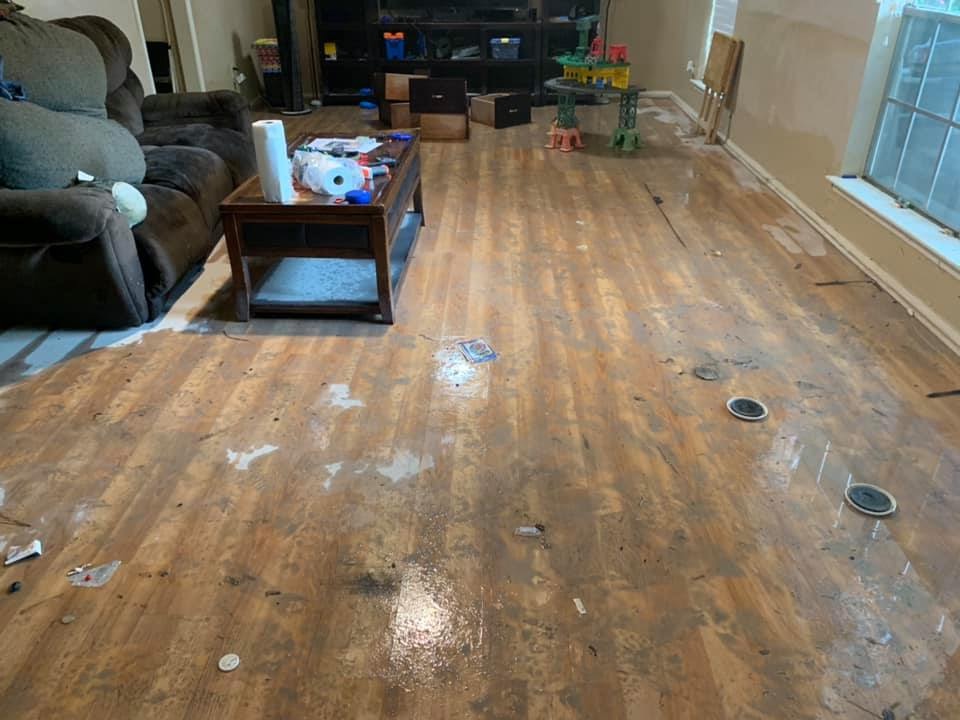
Floodwater in Giles living room during Imelda. When family saw water coming up during second flood, they immediately started moving furniture upstairs.
Rehak: And you’re done now with the second rebuild?
C. Giles: We have the windows and doors that need to be replaced. The front door and the sliding glass doors must be taken out. And these windows, because the muddy water came through them.
When water receded, a thick layer of mud covered everything. So much sediment could only have come from one place: Woodridge Village.
Rehak: You’re considering selling the house?
Impact of Floods on Neighborhood
C. Giles: We know it’s NOT going to be a fast turnaround. Realtors said that we have to have several big storms and NOT flood for people to have confidence that this is going to be a safe neighborhood again. Meanwhile, the majority of our neighbors have already left.
Rehak: How many people on the block?
C. Giles: On our corner, we’ve lost all four families. It’s like a ghost town here. In the cul de sac, they’re all gone, too.
Picture of neighbors house. Water still had not receded well after dark
E. Happ: At least 20 families here are gone. I sit on the porch all day because I smoke, so I see things and keep count.
Rehak: How far down the block did homes flood?
C. Giles: On our street, only two or three houses didn’t get affected by the first flood, but everybody got affected in the second. It was more…devastating.
Home Values Under Water
J. Happ: The house across the street, around the corner, they finished remodeling the whole inside just before the May flood. And they were getting ready to sell it. The day before the flood, their realtor was going to put up a sign, but he decided to hold off. Then we had the flood. Well, they had the house up for $220,000. They only sold it for $115,000. They lost $100,000.
E. Happ: People in here had to just walk away from their homes.
Rehak: Really?
Group: Yeah. Yes.
E. Happ: Houses are still sitting there.
CJ: There’s a house…they never gutted it from the first flood. They just up and left.
Rehak: How is that affecting you? Are there squatters or animals moving in?
Crime Up
C. Giles: Well, crime has picked up. We have all kinds of homes being broken into now. I mean, people are still living in campers and stuff and their houses are getting broken into. It’s just sad.
E. Happ: Contractors have left their vehicles in the neighborhood overnight. They’ve got broken into and all their equipment stolen. Luckily, that has not happened to our contractors.
C. Giles: The thieves don’t realize or care that people still live here. They think we’re all gone.
Rehak: Where do you go from here?
Post Traumatic Stress and Spinning in Circles
C. Giles: We are just taking it one day at a time and finally finding some normalcy. But then, the other night when it rained, I just sat there, you know, praying, “Please watch over my house.” Even my little autistic one, Maverick, who drew the picture of the house crying, could not go to sleep till like midnight.
Picture of house crying, by seven-year-old autistic Maverick Giles. The black part is tears, says Maverick. He says it represents him missing his home.
CJ: None of us sleep.
E. Happ: Maverick was so nervous. All he could do when he came in the house was spin in circles.
That’s how Maverick dealt with the house being all topsy-turvy. He’d just spin in circles.
Evonne Happ
C. Giles: It would be hard to move now. People are losing money on their houses and we’re just not in a place where we can afford that. So, we’re just trying to hang in there.
From Left to Right: Jerry Happ, Evonne Happ, CJ and Catrina Giles in front of their home on Shady Gardens in Elm Grove, now almost restored a second time.
E. Happ: We’ve been living here for the past five years. We’re gonna be leaving in the summertime, probably by August. I’ll go back to South Carolina. I can deal with those damn hurricanes; you can get out of their way. This! It just happened so fast. Each time.
Long-Distance Help
Rehak (to Catrina): What does your husband do?
C. Giles: He’s a quality manager working on a large project in Finland now.
Rehak: So, you’re restoring all this by yourself without your husband’s help?
C. Giles: He helped coordinate the insurance, inspections and contractors, but for the rip-out and rebuilding of our home…he hasn’t been able to be a part of that because of his work.
Two Wrongs Don’t Make a Right
Rehak: What do you feel about Perry Homes at this point?
C. Giles: Well…there’s anger. They just really need to be held accountable for what happened.
J. Happ: These houses were built more than 35 years ago. They’ve gone through hurricanes. You know, large rainstorms, whatever. NEVER been flooded. All of this happened since they started building that development.
C. Giles: Right. Our street flooded during Harvey. But the water never came up in the yard even. Perry just needs to know that they not only affected adults. They affected animals. They affected children.
Some children have a Ziploc bag of their clothes right beside their bed. That’s so if they flood again, they have a change of clothes.
Catrina Giles
Rehak: If you had Kathy Perry Britton sitting right here across the table from you, what would you say to her?
C. Giles: Well. (long pause) I’d be nice. Two wrongs don’t make a right. So, we would pray for her and hope that she made the right decision and fixed that (pointing to development). Because too many people have been affected by this. Our community has been tarnished.
https://i0.wp.com/reduceflooding.com/wp-content/uploads/2020/02/Catrina-Giles6.jpeg?fit=960%2C720&ssl=1720960adminadmin2020-02-08 12:50:452020-02-08 12:56:56Giles Family Struggles to Overcome Two Floods; Prays for Perry Homes to Do Right Thing
Mayor Pro Tem Dave Martin announced that Kingwood Storm-Water Line Inspections will continue and improve.
Houston Public Works will inspect junctures more critically. Martin’s office elaborated no further.
How It Works
“Most inspections already conducted have been clear,” said Martin. “Only a few spots needed debris removal.” The City, he says, addresses areas with debris in the lines prior to moving on to the next neighborhood. They use specialized equipment and “confined-space” personnel to remove the debris. To date, the City has inspected nearly 150,000 linear feet, or approximately 28 miles, of storm-water lines.
Order of Priority
The City has completed Elm Grove, Hunter’s Ridge, North & South Woodland Hills, Bear Branch, Forest Cove, Greentree Village, and Kings Crossing. This week, Houston Public Works started on Kings Point. Houston Public Works now expects to complete one community each week.
When Public Works finishes in a community, they post photos from their storm-water line inspection to Council Member Martin’s Facebook Photo Albums. If you see Houston Public Works crews conducting an inspection, Martin invites you to please say “hi” and watch how they work.
Houston Public Works has prioritized villages in Kingwood by the number of homes impacted during Imelda. The Department hopes to complete the project by June 1, 2020, weather permitting.
Working with HOAs to Alert Residents
Prior to Public Works moving to a new Village, Martin’s office will work directly with the affected HOA to make them aware of the impending storm water-line inspection.
How You Can Help Avoid Streets Flooding
Martin encourages the community to participate in the City’s Adopt-A-Drain program.
Other ways residents can help:
Make sure trash cans don’t tip over before pickup.
Dispose of yard clippings and leaves properly.
Clear gutters before bad weather.
Never throw trash down drains or inlets.
Just In Time for Storms Next Week
Harris County Meteorologist Jeff Lindner warns, “Widespread rainfall amounts Sun-Wednesday night look to average 1-2 inches across much of the area.” However, also says we could see totals of 3-4 inches or even higher along and east of I-45 if a surface low tracks over the area next Wednesday.
Posted by Bob Rehak on 2/7/2020
892 Days since Harvey and 141 since Imelda
https://i0.wp.com/reduceflooding.com/wp-content/uploads/2019/05/Victim_03.jpg?fit=1000%2C1500&ssl=115001000adminadmin2020-02-07 19:29:112020-02-07 19:49:02Kingwood Storm-Water Line Inspections Update
On January 25th Sharon Mize and her husband, B Ray, drove around Lake Conroe to see the impact of the lower lake levels on boating, fishing and commerce. Even though the water level was still at 199 feet, they saw dozens of boaters; full parking lots at the boat ramps and restaurants; and people getting boats in and out of the water.
On Jan. 25, 2020, SJRA recorded the lake level at slightly more than 199 feet.Screen capture by Sharon Mize.
An Outsider’s View on a Cold and Blustery Day
The Mizes quickly point out that they do not have enough history with Lake Conroe to determine whether what they saw was “normal.” However, they characterized the activity as “healthy,” despite a cold, blustery, overcast January day.
As you look at the photos below, look not only at the activity in the shot, look at the waterlines on piers and docks relative to the water level.
Photo taken from Wolfies restaurant at Lake Conroe ParkHouse and slip across from Wolfies. Note fisherman at right.Bulkheading across from Wolfies shows normal and current water lines.Slips by restaurants at Waterpoint Marina. Note normal water level on posts and smile on woman.Activity at Waterpoint MarinaBoats tied up at restaurants at Waterpoint Marina. A restaurant owner told me that business was down seasonally, but that it was normal year over year. The owner estimated winter was down 20% compared to the peak in summer during vacation season.Waterline at Waterpoint MarinaBoat Ramp still usable at La TorrettaWalden Yacht Club. Note normal waterline on pier in foreground.Fishermen near Walden Yacht ClubNote difference between water level and normal waterline on docks at Walden Yacht Club.The heaviest orange color shows the most common level of the lake. B Ray Mize estimates the lake was down about 12 to 18 inches compared to that.Boats entering and leaving harbor at Walden Yacht ClubAnother waterline on docks at Walden Yacht ClubShoreline across from Scott’s Ridge Boat Ramp. No excessive exposure of sediment at 199 feet.Boats by Scott’s Ridge Boat RampScott’s Ridge Boat Ramp Parking Lot filled with empty boat trailers.Boat about to land at Scott’s Ridge boat rampParadise Point North Boat Launch
In fact, during the months SJRA intentionally lowers the lake 1-2 feet, the lake level AVERAGES about 199.5. So, Lake Conroe residents would only lose about another half foot.
The 46-year January average for Lake Conroe’s level is 199.54, according to the SJRA. Note also that the average for any month has never exceeded 200.44 since the lake was built.
For more background on this controversy, see the Lake Lowering page on this web site.
Posted by Bob Rehak on 2/6/2020 based photos and input from Sharon and B Ray Mize
891 Days after Hurricane Harvey
https://i0.wp.com/reduceflooding.com/wp-content/uploads/2020/02/D-10-Walden-Yacht-Club-copy.jpg?fit=1200%2C533&ssl=15331200adminadmin2020-02-06 16:09:172020-02-06 17:48:18Lake Conroe at 199 Feet: Photos Show Little Impact on Boating, Fishing, Commerce
At its Feb. 20 board meeting, the San Jacinto River Authority will decide whether to continue lowering Lake Conroe temporarily until other flood mitigation measures can be put in place. Before then, Donna Dewhirst, a resident of Walden on Lake Houston, wanted to share some reminders of the damage that Harvey and the 80,000 CFS Lake Conroe release inflicted on the Lake Houston area.
A Horror Story in Pictures
Dewhirst’s outdoor kitchen took on knee-deep water. In the background, that’s the second story of her boat dock.As water started to subside, Dewhirst found trees and other debris lodged in her dock. The flood destroyed her boat.A 70-foot surprise became visible when floodwaters receded. The flood also destroyed Dewhirst’s boat.The railroad bridge just down from her caught another boat swept away in the flood.
“The water reached my back porch at the foundation of my home, but amazingly my house and garage got no water in them,” said Dewhirst.
Dewhirst feels lucky.Her neighbors less so.As water receded, the extent of flooding became more apparent.
“It was horrific,” said Dewhirst. “But we were lucky compared to others. I planned returning to a flooded home, but God of Heaven spared me. My son in law had put Flex Seal on the back doors and taped it with duct tape a few feet up. I’m sure that helped. But honestly from the water line on the house, it truly was a sheer miracle we didn’t flood.”
Can It Be Averted In the Future?
Aerial view of Aquatic Drive on Walden on Lake Houston after the Conroe release. Dewhirst believes this photo came from Greg Toole. If not, please let me know. I will correct the credit or remove the image if the author wishes.
If lowering Lake Conroe temporarily until other flood mitigation measures can be put in place, such as additional flood gates on the Lake Houston dam, I’m all for it.
For more information about that program and how to make your voice heard, visit the Lake Lowering page on this web site.
Posted by Bob Rehak on 2/5/2020
890 Days after Hurricane Harveyand 15 days before the SJRA decision
Nancy Vera and Edythe Cogdill live across the street from each other at the northern end of Village Springs. They moved to Elm Grove to build an idyllic life for themselves and their families. For years, it was a quiet, peaceful neighborhood filled with friends and block parties. Kids played in the streets and rode their bikes to schools on greenbelts. From their front porches, they could look north across the Montgomery County line and see forest laced with streams and trails. Then the bulldozers came. And spring rains. Suddenly, they found themselves at ground zero in a battle with Mother Nature, corporate giants, and a neighboring county that cared more about development than protecting downstream residents from flooding. Each woman flooded twice last year. As I interviewed them together, they shared their thoughts on every aspect of the experience.
Cogdill and Vera live at the tip of this 268-acre clear-cut funnel created by Perry Homes. See white dot for approximate location. Perry still has yet to install 75% of the promised detention.
Rehak: How badly did you flood in May and September?
Cogdill: We had about nine, 10 inches, in May. And 22 inches outside the fence during Imelda, but only 12 or 13 inches in the house. Our fence deflected a lot of water.
Edythe Cogdill looks with worry at Perry Homes’ Woodridge Village. Her home and camper are behind her. Her home flooded twice last year from Woodridge. She captured the harrowing ordeals on video to share with the world.
Rehak: And Nancy, in May, how much did you get?
Vera: We got two feet.
Rehak: And in Imelda?
Vera: Three.
Impact of Flooding on Neighborhood and Home Values
Rehak: We walked your block and discussed each house. All but one flooded. And you are the only two original families left. It’s like you’re living at ground zero.
Vera (left) and Cogdill (right) fret about the impact of renters on their once idyllic neighborhood.
Cogdill: Yes.
Rehak: Most of these other houses have sold to investors?
Cogdill: All with the exception of the one that has a brother living in it now. That family has to keep the house because they just bought it last year; they can’t afford to sell.
Rehak: Talk to me about property values in the neighborhood.
Cogdill: The house next door sold for $93,000. Our appraisal last year was $214,000.
Rehak: So it went for about half?
Cogdill: Another sold for $105,000.
Vera: It was appraised before the floods at over $200,000.
Rehak: Again, about 50 percent. Would that be a fair estimate for these others up and down the block?
Vera: That’s what I’ve been hearing. My son’s friend’s house sold for eighty. That’s on the next street over.
Vera: Most people are getting $80,000 to $100,000 now.
Homes on their block seem to have been in a perpetual state of repair since last May.
Rehak: And what would that one have gone for before?
Vera: $160,000 to $200,000 depending on square footage.
Rehak: Still, about 50 percent.
Vera: Yes.
Remodeling Right Before Flood
Cogdill: We totally remodeled our house in March of 2018, a year before the flood. All new paint inside and out. Totally gutted the bathroom and redid it. Added a very expensive back porch. And then it flooded.
Rehak: Did you have flood insurance?
Cogdill: We did.
Rehak: You did, too? (To Vera)
Vera: We did not have flood insurance in May. But I got flood insurance within a week after the first flood.
Vera’s living room has been reduced to “life with lawn furniture.” She has lived this way for almost a year. She and her husband have so little faith in Perry’s promises to fix Woodridge that they postponed repairs until after hurricane season.
Flood Insurance Experiences in Back-to-Back Floods
Rehak: Talk to me about your flood insurance experiences. You said one of your neighbors had a problem. Even though most of the house was rebuilt after the first flood, they didn’t get credit for that?
Cogdill: The adjuster merged the claims because they did not have their inspection complete before the second flood. They were going to get something out of the second flood, but it didn’t nearly cover the loss. They had to redo everything. And they weren’t reimbursed for everything.
After the second flood in five months and hassles with insurance adjusters, Vera’s neighbors gave up. An investor bought their headaches for 50 cents on the dollar.
And then they took a $10,000 loss on their camper. They bought the camper to live in after the May flood. They were days away from moving back into their house. And then everything – house AND camper – flooded again in September. So they were upside down. Her insurance gave them $10,000 less than what they owed on it.
Never-ending Parade of Contractors
Vera: I just want to get everybody out of my house, because every day, every day, every day, somebody is there.
Rehak: You have no privacy anymore?
Cogdill: You have contractors that say, “We’ll be there at 7:00 a.m.” And then they don’t come. Or you might take off work to let someone in and they don’t show.
Vera: And I had to buy cameras to put in my house, so I can see them.
Cogdill: The lady with the camper worked from home. And they would pound on her door every time, “Well, we’re here.” And she would be on a conference call. She just said, “I can’t do this anymore.” They’re gone now.
Managing Repairs and Full-Time Jobs
Rehak: I hadn’t really considered the “time off from work” aspect of all this. Nancy, you and your husband both work.
Vera: He can’t really take off because he’s overseeing a massive construction project. So I’m doing all the taking off.
Rehak: Where do you work?
Vera: I work for an insurance company. We handle benefits for school systems that we sell insurance to.
Cogdill: I was the construction manager on our rebuild. We were completely done with the remodel from the first flood.
Rehak: How long did it take you?
Finishing First Repairs Then Flooding Again
Cogdill: We finished two weeks before the September flood.
Rehak: How did that feel?
Cogdill: I sat down and I cried. It was exactly like the May flood. I was home alone and calling my husband every ten minutes, and then … then when it came in the back door, I just started bawling. And nobody could get home until right before dark. It started like eight o’clock in the morning.
Home Alone in Rising Waters
Rehak: What does it feel like when the water is coming up?
Cogdill: Everybody’s telling me on the phone, “Do this and do that. Put this up and get the dogs. Be sure you get your medicines. And I’m just looking around like, wow, OK, the dogs are walking through puddles … in the house. We lost our car in the first flood. It was in the driveway.
Postponing Rebuild and Wondering
Rehak: Nancy, after the May flood, you were a little skeptical about what Perry was going to do. So, you didn’t rebuild immediately.
Vera: We lived in a house with no walls, nothing all summer. We put up that Tyvek paper on all the walls. So that kinda helped. My house never got too hot. We were lucky; our air conditioning was brand new. It held up when everybody else was losing theirs.
Rehak: So, when the second flood came, you didn’t have demo to worry about?
The Vera kitchen after two floods, the first without insurance.
Vera: Partially. We had more damage the second time. A lot more.
Rehak: That’s right. You said it went up another foot. When did you make the decision to renovate and why?
Vera: We waited until hurricane season was over. And we said we would try to get it done as soon as possible. I was my own project manager to save money. We’re still on the fence as to whether we should sell and walk out.
I Bought This To Be My LIFE
Rehak: Let’s talk about that. Do you think Perry will sort this out?
Vera: You want to have hope.
Cogdill: You hope that they’re human. You want to keep your home.
Vera: This is my home. It’s not an investment. I bought this to be my LIFE.
Cogdill: This is where I wanted to raise our kids. That’s the reason I live here.
Vera: I don’t want to give up hope because in my gut I don’t want to sell my house. But then do you trust that they can fix it after you flooded twice … and you see that they’re not actually out there doing ANYTHING to problem solve?
The Cogdill and Vera families fret over the Perry detention pond that seems to be under perpetual construction. Building additional detention capacity that might help prevent future flooding does not seem to be a high priority for Perry. Meanwhile, they live in a state of perpetual fear.
Cogdill: It’s fixin’ to be, you know, flood season and all that. Why have they not been doing anything?
Rehak: What would you like to see done out there now?
Cogdill: This is such a hard question because there have been so many things out there that people have said could happen, may happen. The most recent one is to make a 300-acre lake out of it if Harris County Flood Control takes over. But I have worries with that, too. Look at all the places that flood in Harris County.
Vera: Right now, we’re very gun shy about anything. We don’t have the correct answer either, because we’re not experts. All we know is that we don’t want to flood again.
Biggest Fear for Neighborhood
Rehak: Beyond flooding again, what’s your biggest fear for the neighborhood?
Cogdill: Renters won’t take care of property as much as homeowners. They’re not going to keep up their yards. They’re not going to care about landscaping.
Rehak: Beyond your block, how many homes in this area have flipped or are up for sale.
Vera: Close to a hundred.
Ten homes in a row for lease in North Kingwood Forest by the same company. These are directly across Taylor Gully from Vera and Cogdill.
Cogdill: I would say 40 percent.
Rehak: How many more homes do you think flooded the second time than the first?
Vera: About 200 flooded the first time. At least 400 the second.
Living in a State of High Alert
Rehak: What would make you happy at this point?
Cogdill: We just want things back to normal.
Rehak: What do you consider normal?
Cogdill: Not living with the fear. To have everybody’s homes that have been destroyed fixed, repaired, restored back to the original.
Cogdill can never escape the fear of living with the development in the background.She worries about flooding a third time before someone fixes the problem.
Vera: Not to worry every time there’s a storm coming. We were up all night last night, even though we were told we were not going to flood again. But everybody was still glued to the TV, because we’re always on high alert. We ARE going to flood again because nobody has solved this problem. What do I want? To NOT live with anxiety all the time. But it’s always there.
Cogdill: I want to get back to a place where everybody is not whining, complaining, or scared. I want everybody’s homes fixed and to say, “Hey, we’re having a block party this month.” I just want to live in a normal community that’s not consumed with fear.
Accountability and Oversight
Rehak: What role do you see Montgomery County Government playing in all of this?
Cogdill: Montgomery County should be liable. City of Houston should be liable. And once these people start being held liable over this stuff, maybe they’ll stop letting it slip through the cracks. You know, it’s just somebody somewhere along the way pushed a bunch of stuff under the rug. And all of them shut their eyes to it. They all should have been involved. But my understanding is that Montgomery County won’t come inspect it. They have a job. And they should do it.
Vera: My biggest concern is that I don’t know what we can do about it. And we get a lot of spring rain.
Running Out of Hope
Rehak: Have you considered raising your foundation?
Vera: It was going to be like close to a hundred thousand dollars to do it.
A never-ending story: Once immaculate lawns and proudly maintained homes have given way to trash piles.
Rehak: Last question. What do you feel about the way Perry Homes has handled this?
Vera: I think they’re sick.
Such is life at ground zero in the flood zone.
Posted by Bob Rehak on 2/4/2020 with thanks to Nancy Vera and Edythe Cogdillfor sharing their experience
890 Days since Hurricane Harvey and 139 since Imelda
The thoughts expressed in this post represent opinions on matters of public concern and safety. They are protected by the First Amendment of the US Constitution and the Anti-SLAPP Statute of the Great State of Texas.
https://i0.wp.com/reduceflooding.com/wp-content/uploads/2020/02/20200111-RJR_6372.jpg?fit=1200%2C800&ssl=18001200adminadmin2020-02-04 19:48:332020-02-05 05:38:00Life at Ground Zero in Elm Grove
Last week, according to the Houston Chronicle, Harris County Commissioners discussed in executive session a deal to purchase the Woodridge Village development in Montgomery County. Woodridge Village has contributed to repeated flooding of Elm Grove and North Kingwood Forest. At issue: the possibility of turning the land into a regional detention facility that could help the affected communities and others on the East Fork of the San Jacinto.
Bizarrely, the article implied that Harris County Commissioners would be letting developers “off the hook.” What hook? Yes, Perry Homes is being sued by hundreds of homeowners. But Commissioners have nothing to do with the lawsuits and can’t influence them. The lawsuits are moving forward independently, as the article points out later.
The article claimed the parcel being considered for purchase is inside city limits. It is NOT. It is, however, within the City of Houston’s extra-territorial jurisdiction.
Another inaccuracy: The article said “Elm Grove” sits inside the 100- and 500-year flood plains. Only a portion of it does.
Getting to the Heart of the Mystery
The article claims that the new development also sits in floodplains. I agree. But now we’re getting to the crux of the flooding issue and the mystery surrounding these floods. This is where the Chronicle could have won a Pulitzer.
More than a year and a half after Perry Homes clear-cut this land and Elm Grove flooded twice, Perry Homes still has not even completed a quarter of the required detention pond capacity.
A glance at the construction plans and drainage analysis would have shown that Perry Homes did not build what was on paper. They failed to follow the permitted plans.
Perry obtained permits by saying it intended to develop only 30 of approximately 188 acreson the northern portion of the site in Phase 1. They then cleared the entire site, including the “non-existent” wetlands.
To add insult to inaccuracy, the article then goes on to claim that portions of Kingwood have flooded repeatedly in the last five years, as if that explains Perry’s problems. But those areas are not even in the same watershed as Elm Grove! They have separate issues; those other areas were built in the floodway of the San Jacinto river. Elm Grove, on the other hand, never flooded before Perry clear-cut 268 acres immediately upstream from them and then filled existing streams.
Dubious Slant Could Rile Up Voters, Torpedo Deal
Whether intentional, unintentional or both, the article’s omissions, inaccuracies, and mischaracterizations could rile up voters who may fear their tax dollars are being wasted by the “bailout” of a billion-dollar company that they don’t especially like. That kind of publicity often scares authorities who fear blowback. And that, in turn, could torpedo any land purchase and doom desperate people to more flooding. I sincerely hope not.
Advice for Houston Chronicle
If the Chronicle wants to write about this issue, I suggest they research it. Don’t just call both sides and think you have done a good job of balanced reporting. Get to the damn truth. Then maybe more people would buy subscriptions. Why:
People’s lives, homes, lifesavings, and sanity are at stake. I sincerely hope the Houston Chronicle starts digging for answers, instead of shoveling bull.
Posted by Bob Rehak on 2/4/2020
889 Days since Hurricane Harvey
The thoughts expressed in this post represent opinions on matters of public concern and safety. They are protected by the First Amendment of the US Constitution and the Anti-SLAPP Statute of the Great State of Texas.
https://i0.wp.com/reduceflooding.com/wp-content/uploads/2020/02/20200125-RJR_7493-2.jpg?fit=1200%2C800&ssl=18001200adminadmin2020-02-04 15:55:172020-02-05 10:09:46Would Purchase of Perry Homes’ Woodridge Village by HCFCD be a “Bailout”?
More than 850 days after Hurricane Harvey, the City of Houston has released a 170-page report called Living with Water™. (Caution: 60-meg download.)
A Primer on Green Flood Mitigation
In many ways, Living with Water is a primer on flood mitigation in the Bayou City. It lays out many of the problems we face as a region. It also points to many innovative solutions. It even takes three neighborhoods within the City (Greenspoint, Kashmere Gardens, and Independence Heights) and shows how various “green” strategies could reduce flood risk.
So far, nothing to argue with. The primary value of Living with Water lies in raising awareness of opportunities that can be used to solve problems throughout the region.
High-Level Ideas with No Actionable Plan Yet
But if you were looking for specifics – case studies, costs, plans, timetables, and budget line items associated with recommendations – you will be sorely disappointed. This isn’t that kind of report. And the absence of those specifics 887 days after Harvey will frustrate many who believe we should be far past brainstorming at this point.
Living with Water contains many magic-wand solutions that people in workshops often develop.
For instance, they identified “cooperation” as a strategy. Yet they failed to identify how to get upstream interests to factor downstream impacts into their development costs willingly.
From 2001 to 2016, most new development took place outside the Houston city limits. Yet during the first two decades of this century, the region added approximately three million people, nearly doubling in size. This creates development pressure in low-lying and risky areas that can impact downstream areas.
Another example: the creation of “interceptor streets.” They are never fully defined, but have something to do with storing stormwater under historic streets. Ten years after the implementation of the drainage fee, have we had one such project developed anywhere in the City?
Finally: a recommendation to “Bring back the prairie.” Great. Now how?
The Benefit: A Shared Vision of the Future
Regardless, it’s important that we share a possible vision of the future if we are ever to agree politically on solutions. Living with Water paints a positive vision of what that future could be. It also provides many tangible examples of how we could get there.
In the end, people will remember Living with Water for one thing. It shows how we could turn stormwater from the enemy into a series of amenities that enrich City life.
Whether this effort turns into reality or “credenza-ware” will depend on how quickly the City can implement pilot programs that demonstrate practical, achievable, cost-effective, flood-reducing benefits.
Posted by Bob Rehak on February 2, 2020
887 Days after Hurricane Harvey
https://i0.wp.com/reduceflooding.com/wp-content/uploads/2020/02/New-Development.jpg?fit=1200%2C1035&ssl=110351200adminadmin2020-02-02 18:05:132020-02-02 18:10:29City of Houston Releases “Living With Water™” Report
The first placement area: an active sand mine south of the Kingwood College between Sorters-McClellan Road and the West Fork. Note all the sand in the picture below. This sand mine was for sale, but the dredging spoils gave it new life. From here, sand goes to new construction projects across north Houston and southeast Montgomery County.
Looking SE at Placement Area 1, the Eagle Mine. West Fork San Jacinto in lower right. Sorters-McClellan Road cuts diagonally through top of frame above sand mine.Photo taken 1/20/2020.
Placement Area 2
The second placement area: an old pit on Townsend behind some flooded apartments in Humble.
Townsend in foreground turns from east/west to north/south. The apartments were heavily flooded during Harvey. West Fork and Army Corps Command Post in background. Some of this sand being sold too.
Placement Area 3: Berry Madden’s Property
Placement Area 3 is Berry Madden’s property south of the West Fork but north of FM1960. The water below is a back channel of the West Fork. Here, the spoils are being barged in from the mouth bar. The barges offload in the center left and the spoils are trucked inland. Should the dredgers shift over from mechanical to hydraulic dredging, this property can accommodate that.
Berry Madden’s property south of San Jacinto West Fork, west of Kings Lake Estates. Photo taken 1/20/2020. This placement area is just starting up. It will accommodate additional sand taken from the West Fork Mouth Bar. See below.
A Look at Mechanical Dredging
Currently, DRC is mechanically dredging the West Fork Mouth Bar. In hydraulic dredging, sand is pumped upstream continuously via pipeline. In mechanical, excavators scoop sand onto a barge, which shuttles it to a placement area as the pictures below show.
Excavator loads sand from west end of mouth bar onto waiting dredge.Photo by Josh Alberson 2/1/2020.Wider shot shows a second excavator and another barge working together farther east.Photo by Josh Alberson 2/1/2020.60-80 cubic yards are loaded onto a barge which is pushed upriver to Madden’s property. Photo by Josh Alberson 2/1/2020.After offloading, it returns to mouth bar for another load. Round trip time on Saturday afternoon: about 3 hours.Photo by Josh Alberson 2/1/2020.Back at the mouth bar, it’s time for a reload. Photo by Rachel Taylor, 2/1/2020.Bottoms up. Photo by Rachel Taylor, 2/1/2020.
Posted by Bob Rehak with photos from Josh Alberson and Rachel Taylor on February 2, 2020
887 Days since Hurricane Harvey
https://i0.wp.com/reduceflooding.com/wp-content/uploads/2020/02/20200120-RJR_7445.jpg?fit=1200%2C800&ssl=18001200adminadmin2020-02-02 04:19:042020-02-02 14:13:36What Happened to Sand From West Fork Dredging?