On 7/23/2020, consultants for the San Jacinto River Basin Master Drainage Plan gave the SJRA Board and the public a first look at a draft of the plan. The final report is due out at the end of August. The draft shows the broad outline of the team’s efforts.
Draft Shows Broad Outline of Recommendations
It shows the types of recommendations they will make. However, this draft does not yet include specific recommendations as to prioritization of projects. Those will change before the final report. For instance, much of the draft focuses on upstream detention. But specific detention site recommendations have not yet been finalized.
Funding and Partners
Below are the key slides and a brief explanation of the main point behind each. This drainage study is 75% funded by a FEMA Hazard Mitigation Grant and 25% by four local partners: the SJRA, City of Houston, Harris County Flood Control, and Montgomery County.
Scope of Study
The study area covers almost 3,000 square miles and the tributaries listed on the left.The SJRA primarily has responsibility for the portion of the watershed in Montgomery County. However, the scope of the drainage study extends to other counties including Waller, Grimes, Walker, Liberty, and San Jacinto.
Heat Map Shows Where Most Damage Occurs
The team started by looking at where flooding has occurred historically. The tan areas aboveshow where the most damage has occurred.
Goals and Methodology
The partners started by looking at vulnerabilities and identifying mitigation possibilities. Their main goals are in red. The final report will make specific recommendations for detention, buy-outs and improving conveyance. Recommendations will also improve flood warning and communication.The team started by integrating and updating all existing hydraulic and hydrologic models in the watershed as reflected on the latest 2018 lidar terrain data. They now take into account new construction, growth, additions to impervious cover, and Atlas-14 rainfall probabilities (which vary by sub-watershed within the larger watershed).To calibrate and verify its H&H models, the drainage study team examined four historical storms that, together, impacted the entire study area. They then adjusted the models using radar rainfall data, and USGS high water marks and peak flow data. The objective: to make the models reflect “ground truth.”The team is also looking at strategies to reduce sedimentation. However, this is not a major focus of this study. Their purpose is not to evaluate the relationship between sediment and flooding. Other studies will do that.
Three Main Areas of Focus
This slide shows the three major thrusts of drainage study effort over the last 1.5 years. The primary focus has been on: a) identifying the best locations for upstream detention that can reduce the volume of water coming downstream to populated areas during floods, b) where to install additional gages to improve flood predictions and warning times, and c) improving communication during emergencies.This shows the steps the drainage team went through to evaluate and rank-order potential sites for detention.
Areas of Highest Potential for Mitigation
Here’s where they found the highest and lowest potential for mitigation. The box explains the watersheds that see the most effective solutions within the SJMDP study area, as explained in the list to the left of the slide.Some drainage projects recommended in previous plans are no longer possible today because of upstream development. However, areas that once held potential for a single large project still hold potential for several smaller projects that add up to significant flood reduction.
Mitigation Project Funding
The cost all the drainage projects identified adds up to about $3 billion. They only reduce flooding of structures worth about $756 million dollars. Because costs exceed benefits, FEMA will not likely fund all of these.However, many of the projects are in areas with low to moderate income (brown and tan areas). See the large concentration in the eastern watershed. That opens up other sources of funding, such as the Department of Housing and Urban Development where the benefit/cost ratio may not be as important.
Harmonizing Regulations Throughout Region
The team will also make recommendations to harmonize floodplain development regs throughout the region. Continuing to allow unmitigated upstream development in floodplains could destroy any new investment made to protect highly populated downstream areas.
Some Problems May Only Be Solved Through Buyouts
Buyouts usually have a high benefit-to-cost ratio relative to construction projects such as detention ponds. Buyout strategies can target the most vulnerable properties, such as those in the 2- and 5-year floodplains. None of the detention projects recommended by the team will likely remove those from danger.
Steps Still Not Completed
The team has finished the steps in red. They in the process of prioritizing projects and developing a phasing plan. The last bullet point is not part of this study.
More Upstream Gages Needed to Eliminate Blind Spots
The team has also identified locations for additional upstream gages and local partners who can help maintain those gages. Think of these like a “distant early warning” system. They give river forecasters visibility into “blind spots.” Forecasters will be able to add up the rainfall on various tributaries and predict the impact and timing of flooding downstream.That could give people more time to evacuate.
Ways to Improve Communication
The team is also looking at ways to communicate better during flood emergencies. They are looking at inundation mapping, evacuation routes, and improved communication protocols.
Timetable for Remainder of Project
This chart outlines the project workflow. It shows completed steps in red, and incomplete steps in yellow.The final report with specific recommendations should be released at the end of August or in early September.
Every Little Bit Helps
I can’t wait to see this report in its final form. During the presentation, the presenter talked about reducing flooding downstream at the West Fork and I-45 by up to six feet if all upstream projects are implemented.
One thing to keep in mind: there is no single silver bullet that can solve the regions flood problems. All of these steps are additive. In my personal opinion, a foot here and a foot there can help offset future releases from Lake Conroe. People in the Lake Houston Area benefit from any and all upstream improvements.
Posted by Bob Rehak with thanks to SJRA and HCFCD
1064 Days since Hurricane Harvey and 313 since Imelda
https://i0.wp.com/reduceflooding.com/wp-content/uploads/2020/07/Screen-Shot-2020-07-23-at-10.27.52-AM.jpg?fit=1500%2C1141&ssl=111411500adminadmin2020-07-28 16:33:252020-08-03 15:02:43San Jacinto River Master Drainage Plan Draft Provides First Look at Final Report Due Out in August
Instead, regular smaller rains kept the lake close to its monthly averages. Neither drought nor excessive heat caused lake levels, property values, business or tax revenues to plummet. Everything functioned much as it normally has since Lake Conroe was built in 1973.
Lake Stayed Near Monthly Averages
In the two months between April 1 and May 31, the lake only dropped below 200 feet by an inch or two for three or four days and then promptly refilled. In fact, at the end of May, 2.5 inches of rain caused the lake to rise above its seasonal norm, prompting a second release.
Two releases and smaller, spread-out rains kept the Lake Houston Area safe and Lake Conroe close to its monthly averages(200.32 for April and 200.44 for May; see below).Source: SJRA Board Presentation 7/23/20. Lake Conroe seasonal levels by month for 46 years. In April and May, Lake Conroe averages 200.32 and 200.44 respectively.Source SJRA Board Presentation.
During that time, the Lake Houston Area never flooded. Yet Lake Conroe was above its monthly average for the first three weeks of April. And it was only down about three inches for about three weeks in May.
The assertion that Lake Conroe is “normally” at 201 is a myth. That is the level at which the SJRA normally starts releases. Due to evaporation, which can take an inch a day, the lake is almost always well below that. A more accurate term for 201 would be “full pool.”
River Levels Up Slightly, but No Flooding
West Fork river levels rarely rose more than 2 or 3 feet even when rainfall was added to the release rate from Lake Conroe.
Release rates averaged about 600 cubic feet per second (cfs) and rarely exceeded 1000 cfs.
If the exercise proved anything, it was that releasing at those rates didn’t flood anyone.
River levels vs. rainfall for the last two weeks of the spring lowering.Source: SJRA Board Presentation 7/23/20.
Fall Lowering Starts This Saturday
The Houston Area lucked out with Hanna. Had the storm veered towards us, we would have received the torrential rains that swamped the Valley.
This fall, the lowering will be split into two phases: to 200 feet in August and 199.5 in September. The City of Houston has the right to call for an additional half foot in the event of a named storm.
Restatement of SJRA lake lowering policy for this year.Source: SJRA Board Presentation 7/23/20.
Even though Hanna missed us and Gonzalo fizzled, the next storm may not.
Finally, note that the target level for August (200 feet) is about an inch ABOVE the normal monthly average. So if evaporation does its job, the SJRA will not have to lower the lake.
Posted by Bob Rehak on 7/27/2020
1063 Days after Hurricane Harvey
https://i0.wp.com/reduceflooding.com/wp-content/uploads/2020/07/Release-Vs.-Lake-Levels.jpg?fit=1500%2C836&ssl=18361500adminadmin2020-07-27 16:12:472020-07-27 16:12:58SJRA Report on Spring Lowering of Lake Conroe
The New York Times ran a story on flood-bond spending, but forgot to look at where the budget to date has gone.
The story by Christopher Flavelle was titled, “A Climate Plan in Texas Focuses on Minorities. Not Everyone Likes It.” It outlined arguments on each side of the equity debate in flood-bond spending. From a balance point of view, it did a great job. However, it came up short in two areas.
Problems with Article
First, the headline misleads.This isn’t about climate. The story is about how to distribute flood-bond dollars equitably.
Second, it makes no mention of where flood-bond dollars to date have actually gone. Nor does it mention historical spending except in a generalized way. It implies poor people got none; rich people got it all. By avoiding research into actual current and historical spending, it perpetuated myths that do little to protect people from flooding.
Had he bothered to check historical or federal spending, he might have found an even more exaggerated pattern.
Trap Laid by Ellis
Mr. Clavelle fell into the trap that Commissioner Ellis laid. In effect, the argument goes like this. “Because homes in poor neighborhoods cost less than those in rich neighborhoods, it brings down the benefit/cost ratio for poor neighborhoods. FEMA considers that ratio in grant requests. That disadvantages grants for poor neighborhoods and perpetuates a downward cycle.”
That’s literally true – if you look only at FEMA grants. But it’s the exact opposite for HUD grants which heavily favor disadvantaged neighborhoods. Mr. Clavelle fails to mention that. As do Mr. Ellis and his surrogates whenever they talk on this subject.
Approximately 70% of those HUD grants MUST go to disadvantaged neighborhoods. The actual percentage varies by storm and type of grant. After Harvey, Harris County received a billion dollars. And the City of Houston received $1.1 billion. Together, that’s almost as much money as in the $2.5-billion flood bond. And there are still billions of additional dollars available from HUD through the General Land Office.
Preserve Your Community
If more of this money continues to go south, the Lake Houston Area is sunk in the next big storm.
The County Judge’s office is inviting the public to share their thoughts and ideas on the proposed draft bylaws of the Community Resilience Task Force. You can register your opinion from now until July 30th, 2020, via one of the following methods:
Email CRTF@cjo.hctx.net and submit comments digitally, beginning July 21
Join a virtual focus group via Zoom. After registering, participants will receive a confirmation email containing information about joining the meeting.
Please express your opinions to the county judge. Nothing is more important to the future of the Lake Houston Area than achieving more balance in flood-bond spending.
Some Key Facts to Consider
Some key points I intend to make:
79% of flood bond projects to date have gone to neighborhoods that rate high on the social vulnerability index leaving only 21% to everyone else. We need to tweak the formula to achieve greater balance.
The argument that FEMA’s emphasis on Benefit/Cost Ratios disadvantages minority neighborhoods ignores the fact that billions of dollars in HUD grants advantage minority neighborhoods. Focusing only on one without acknowledging the other is intellectually dishonest.
HCFCD and USACE have historically underfunded flood mitigation projects in the Lake Houston Area. In the history of HCFCD, the District has not developed ONE USACE-funded project in this area.
For More Information
For more information on the “equity bias,” see this series on “Where Flood Mitigation Dollars Have Really Gone.” It was developed a year ago so the focus is on historical spending.
https://i0.wp.com/reduceflooding.com/wp-content/uploads/2018/07/HumbleFloodFromHCFCD-e1761946748900.jpg?fit=1100%2C821&ssl=18211100adminadmin2020-07-25 20:50:062020-07-25 21:48:15NY Times Covers Harris County Flood-Bond Spending, but Omits Spending Data
Imagine you pull up to a stoplight and two needy people approach you for a handout. You want to help, but have only $1 in your pocket.
Do you give the dollar to the person who has not eaten for the longest time? Or to the person from the zip code with the highest percentage of minorities and lowest average household income?
As you may have guessed, the people at the stoplight are a metaphor for flood victims.
More Needs than Dollars
Harris County doesn’t have enough dollars to build every flood mitigation project that everyone needs. Flood mitigation requires tough choices.
So the County is setting up a supposedly unbiased task force to decide whom to help. But its composition will be biased toward people who believe flood bond money should favor low income, minority neighborhoods, i.e., the constituents of the three politicians pushing the task force (Judge Lina Hidalgo, Precinct 1 Commissioner Rodney Ellis, and Precinct 2 Commissioner Adrian Garcia).
Stacking the Jury
Look at the proposed overview and bylaws for the Community Resilience Task Force. You will see that they embed the concepts of equity, social justice, and social vulnerability into every recommendation the task force will make. For flood mitigation. Housing. Health. Construction. Urban planning. And more. For the next 30 years!
Proposed bylaws for the task force explicitly state that the members MUST demonstrate:
An interest in “equitable” flood mitigation.
Interest in socioeconomic and demographic factors that affect resilience.
So they are baking “equitable” into the job descriptions.
Difference Between Equitable and Equal
“Equitable” treatment sounds like “equal” treatment. But it’s not.
Treating people equally means treating them identically. Treating people equitably means treating them differently, but fairly.
For instance, handicapped people get to park closer to the door. That’s fair…based on need.
But what happens when you start making flood mitigation decisions on the basis of race, income, and social vulnerability? Is that fair to more affluent communities destroyed by flooding?
Because poor people have a harder time recovering from floods, they should get more protection from flooding. They can’t afford to flood (…as if anyone can).
Hidalgo, Ellis and Garcia all advocate the use of a CDC social-vulnerability index and LMI (low-to-moderate-income) data to prioritize flood projects.
They argue in meeting after meeting that FEMA bases grant decisions on a benefit/cost ratio (BCR) that favors neighborhoods with more expensive homes. That’s true, but…
They never mention that Department of Housing and Urban Development (HUD) Community Development Block Grants for mitigation (CDBG-MIT) and disaster recovery (CDBG-DR) already favor poorer (LMI) neighborhoods.
Nor do they mention that the County has already received a BILLION dollars in CDBG-DR funds. Or that the Texas General Land Office is sitting on top of approximately $4.2 billion in CDBG-MIT funds that it’s trying to distribute. The vast majority of those funds must go toward LMI/socially vulnerable neighborhoods. (The exact percentages vary by storm and type of grant. But they often range up to 70%.)
Problems With Basing Flood-Mitigation Decisions on LMI Data
There are two more problems with basing flood-mitigation decisions on racial and LMI data.
First, it ignores need. Shouldn’t projects that help the largest numbers of people or the worst flooding be mitigated first?
Second, LMI data only comes by zip code. Zip codes can mask huge disparities in wealth. So even if you feel poor people deserve more flood protection than the middle class, it’s hard to ensure that result with zip code data. Elm Grove, for instance, is an LMI neighborhood embedded within an affluent zip code.
He did not mention Army Corps of Engineers grants to HCFCD for work on four bayous in his precinct. Nor did he mention that in the entire history of Harris County Flood Control (which dates back to 1937), not one federal dollar has ever been funneled through HCFCD by the Corps for work in the Lake Houston Area.
4 Out of 5 Flood Bond Projects in SVI Neighborhoods
How much have Ellis, Hidalgo and Garcia skewed flood bond spending to date?
During the Commissioners Court meeting on June 30, 2020, Harris County Flood Control was asked to prepare a report to document the status of flood bond risk reduction projects in socially vulnerable neighborhoods. See Item 2E on Tuesday’s Commissioners Court Agenda. It shows a startling fact.
Out of the 145 active bond projects, 79% are located in high or moderately high SVI areas.
Letter from HCFCD to Commissioners Court
The distribution looks like this.
79% of Flood Bond Projects are located in the most socially vulnerable neighborhoods; only 21% in the least socially vulnerable neighborhoods. Source: Memo to Commissioners Court from HCFCD.
If you live in a “socially vulnerable” neighborhood, you’re 4X more likely to have a flood bond project near you.
And those are just the projects based on Flood Bond money. The Flood Control District is also pursuing additional CDBG grants and Army Corps funding to help fund even more projects in socially vulnerable areas. Those projects are not reflected in these percentages.
Rushing Through Public Comment Period
One measure of how much Ellis, Hidalgo and Garcia want to institutionalize their own definitions of equity is that they’re giving only six more days for public comment with little public warning.
You can bet that the commissioners court meeting on the 28th will be packed with surrogate speakers for Ellis, Hidalgo and Garcia who favor the “equity bias.” They’ve shown up in Commissioners Court for months.
Why wouldn’t they? It’s worked. They now have 4 out of every 5 flood bond projects going into their neighborhoods and they could get even more if this task force goes through in its current form.
Meanwhile, the San Jacinto watershed, says the Greater Houston Flood Mitigation Consortium, received 0% of the mitigation budget prior to Harvey, yet had 14% of the region’s damages during Harvey.
How Do We Decide What’s Fair?
So, should projects go to neighborhoods that:
Had the fewest flood mitigation projects?
Flooded the worst?
Help the greatest number of people for the dollars invested?
Are the poorest?
Or should the money be split equally or on some other basis?
Personally, I think decisions like these should be left in the hands of engineers, not partisan politicians.
Register Your Opinion
The County Judge’s office is inviting the public to share their thoughts and ideas on the proposed draft bylaws of the Task Force. You can register your opinion from now until July 30th, 2020, via one of the following methods:
Email CRTF@cjo.hctx.net and submit comments digitally, beginning July 21
Join a virtual focus group via Zoom. After registering, participants will receive a confirmation email containing information about joining the meeting.
https://i0.wp.com/reduceflooding.com/wp-content/uploads/2020/07/Bond-Spending-by-SVI-Index.jpg?fit=1200%2C691&ssl=16911200adminadmin2020-07-24 17:07:032021-07-29 16:06:18Harris County Changing How It Will Choose Which Flood Projects to Support; Welcome to the “Equity Bias”
Overnight, TD 8 turned into Tropical Storm Hannah. Hannah’s track continues to take it toward Corpus and the Rio Grande Valley. The shift in direction compared to earlier projections means wind and rainfall threats to Houston are reduced. However, tropical storm warnings remain up for most of the Texas coastline, including San Luis Pass to the Rio Grande Valley.
Rainfall Amounts
Hanna should produce heavy rains, but the heaviest will fall in South Texas.
While portions of south Texas could see 10 to 15 inches of rain this weekend, rainfall amounts in the Houston area should average 3-5 inches along the coast and 1-3 inches inland.
Jeff Lindner, Harris County Meteorologist
Infrared imagery shows building of Hannah.
Rainfall accumulation for storm durationTotal accumulation in north Harris County is likely to be only 1-2 inches from Hannah.
Of course, that should hold down the risk of flash flooding in the Lake Houston Area, but Lindner says the Weather Service will likely issue flash flood warnings for portions of SE Texas later today. NOAA currently gives the north Houston area only a marginal chance of flash flooding.
Houston has only a 5-10% chance of flash flooding from Hannah.
Hannah Could Strengthen to 65 MPH
National Hurricane Center expects Hanna to strengthen and bring tropical-storm-force winds to portions of the Texas coast. NHC brings Hanna to a 65mph tropical storm at landfall. How long it takes any inner core to form today will determine if Hanna could potentially become a weak hurricane as suggested by some of the hurricane models.
Most tropical storm force winds should miss Houston.
Winds in the Lake Houston Area will not be that strong, of course, but could still reach 20 mph, according to forecasters.
Not the Weekend for Offshore Boating
Lindner says, “Wave heights near the center of Hanna will build today. As the system intensifies, waves could reach 10-15 ft tonight. Some of this wave action will move toward the upper TX coast with seas building today into the 4-6 foot range and 6-9 foot range tonight into Saturday. Large swells generated by the system will result in wave run-up and elevated tides of 1-3 feet starting later today and lasting into much of Saturday along the upper and mid TX coast. Minor coastal flooding will be possible at times of high tides in the typical sensitive areas along the coast.”
Forecast track shows Hannah coming onshore Saturday at 1PM in south Texas.
In summary, the brunt of the storm should miss us. But we will still get sideswiped.
Tropical Depression 8 is very close to becoming a tropical storm, likely later this evening or early Friday. TD 8 is continuing to move toward the WNW at 8mph. However, the track of the storm has shifted slightly south. That should reduce both rainfall and winds in the Houston area, compared to yesterday’s forecast.
Regardless, tropical storm warnings are issued for the TX coast from Port Mansfield to San Luis Pass. And a tropical Storm Watch remains in effect from San Luis Pass to High Island.
Landfall Now Predicted Between Corpus and Rockport
NHC now predicts landfall between Corpus and Rockport around mid-day on Saturday as an intensifying tropical storm, packing winds up to 60 mph. Some models predict it could become a hurricane.
3-5 Inches Still Possible South of I-10
Jeff Lindner, Harris County meteorologist now predicts, “3-5 inches of widespread rainfall south of I-10 with isolated higher totals. “Much of this will likely come from various feeder bands. Maximum totals of 10 inches or greater will be possible from Matagorda Bay southward.”
Winds in 20-30 mph Range
Winds across the Houston region could increase to 20-30 mph by early Friday. Higher winds will occur farther southwest. Says Lindner, “Sustained tropical storm force winds will be most likely near/around Matagorda Bay on Saturday with 40-50mph. Winds of 50-60mph will be likely in the portion of the mid coast from Corpus Christi to Seadrift.”
The National Hurricane Center (NHC) has begun advisories on Tropical Depression 8 in the central Gulf of Mexico. Tropical Storm Watches have been issued for the Texas coast from Port Mansfield to High Island including Matagorda and Galveston Bays.
Recent model guidance brings the system to the Texas coast with 48-60 hours over the Gulf waters. Some show the system over Gulf water for 72 hours as the system slows near the coast. NHC forecasts a 45mph tropical storm slamming the middle Texas coast on Saturday.
Houston should be on the dirty side of the storm.
If this does reach tropical-storm strength, it would be named Hannah. Ironically, another H storm hit Houston called Harvey in 2017. But Harvey happened a full month LATER in the season.
Next USAF reconnaissance flight will depart at 4:45 a.m. CDT tomorrow morning and will determine if a tropical depression or tropical storm has formed.
Source: NHC
Rainfall
Jeff Lindner, Harris County meteorologist, says predicted rainfall rates have increased. Widespread rainfall amounts of 3-5 inches will be possible along and generally south of HWY 105 with higher isolated totals. North of HWY 105 rainfall amounts of 1-3 inches will be possible. There is likely to be swaths of higher rainfall amounts where training bands develop, but where this may occur is difficult to pinpoint at this time range.
Channel 13 tonight predicts that some areas west of Houston could record a three day total of 14-15 inches of rain because of the slow speed of the storm.
Posted by Bob Rehak on 7/22/2020 at 10:30 p.m.
1058 Days since Hurricane Harvey
https://i0.wp.com/reduceflooding.com/wp-content/uploads/2020/07/image001-4.png?fit=897%2C736&ssl=1736897adminadmin2020-07-22 22:28:492020-07-22 22:48:27Tropical Storm Predicted to Make Landfall on Saturday; Rainfall Estimates Increased
Several deadlines are converging to force a decision on whether to purchase Woodridge Village from Perry Homes and turn it into a giant regional detention pond. Every day that passes makes that deal appear more remote for reasons I will discuss below. Luckily, Elm Grove residents have an option, which I will discuss at the end of this post. But first…
Deadline #1: Detention Ponds Nearing Completion
Contractors for Perry Homes have nearly finished all detention ponds on the site. Last week, they were cementing drainage pipes and pilot channels in place.
Gray is the lawyer for Figure Four Partners, Perry’s development subsidiary. In the letter, Gray promised the last item would be completed in 280 days. 280 days from the date of the letter (October 17th, 2019) is July 24 – this coming Friday.
Perry has said that it would not start building homes and roads until they finished work on detention ponds. With that work done, how much longer will they delay?
Deadline #2: 75 Days from County’s Redefining of Deal
Last week, Houston Mayor Pro Tem Dave Martin addressed the Kingwood Executive Group. He said that after the May 19th Commissioners Court meeting in which Commissioners redefined the terms of the purchase, Perry sent a letter saying “you have 75 days or we will sell the property.”
The next Harris County Commissioners Court Meeting is July 28th. They don’t meet again until August 11. Precinct 4 Commissioner Jack Cagle is placing an item on the agenda for next Tuesday to discuss the status of the purchase.
Deadline #4: Perry Says It Has Offer Waiting in Wings
At the same meeting of Kingwood executives, Mr. Martin reported that Perry said it had an offer to buy the property. But he also questioned how firm the offer could be, given all the pending litigation.
Deadline #5: Peak of Storm Season Approaching
Nature always gets the last say. Nature could make everyone involved in this deal look bad if Elm Grove and North Kingwood Forest flood again.
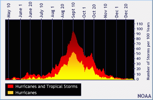
We’re now approaching the peak of hurricane season. Beginning in August, storms start to build rapidly. They peak on September 10. See below.
Number of Storms by Date for the last hundred years. Source: NOAA
We have two storms approaching now. One south of Louisiana. The other still in the mid-Atlantic.
Based on satellite and surface observations, a broad surface low pressure center has formed with the tropical wave moving into the central Gulf of Mexico. NHC has increased the chance of formation to 80% and advised that watches and/or warnings could be issued for portions of the TX and LA coast tonight or on Thursday.
Overall, says the National Hurricane Center (NHC), the organization of the system off the Texas coast is increasing and it is likely that a tropical depression or storm will form in the next day or two as the system moves generally toward the WNW around 10mph.
Jeff Lindner, Harris County meteorologist predicts it “could drop 1-3 inches with isolated totals of 4-6 inches. Heaviest rains may end up close to the coast, say south of a line from High Island to Wharton. There’s still much uncertainty, although visible images this morning show a better organized system in the Gulf.”
Latest satellite images show storm in Gulf building.Gonzalo, the Atlantic storm now looks like it will track into the Caribbean by Sunday and turn into a hurricane.
The second storm intensified this morning and was given the name Gonzalo. According to Lindner, Gonzalo may weaken as it moves across the Caribbean Sea if it encounters wind shear. So forecasters have low confidence in intensity predictions. However, “small systems such as Gonzalo can have rapid fluctuations in intensity,” says Lindner. And most models agree on the path.”
Nature, as they say in poker, could soon call everyone’s hand.
However, widening and deepening Taylor Gully could take some time. And there is intense competition for resources right now. That option could not be constructed in time to head off storms for this hurricane season. So keep your fingers crossed.
Posted by Bob Rehak on 7/22/2020
1058 Days since Hurricane Harvey and 307 since Imelda
https://i0.wp.com/reduceflooding.com/wp-content/uploads/2020/07/20200712-DJI_0035.jpg?fit=1200%2C900&ssl=19001200adminadmin2020-07-22 14:40:392020-07-22 15:00:30Deadlines Converging on Woodridge Deal; Option If Purchase Falls Through
Due to Covid, the San Jacinto River Authority (SJRA) Board of Directors will hold its regular board meeting via webinar Thursday morning. Start time is 8 a.m. One of the more interesting things on the agenda is a first peak at the San Jacinto River Basin Master Drainage Plan. Chuck Gilman, SJRA Director of Water Resources and Flood Management, says that Halff & Associates will provide a high level summary of the results and recommendations.
After registering, you will receive a confirmation email containing information about joining the webinar.
If you choose to participate via the GoToWebinar App, you WILL have the opportunity to provide comments during the designated portion of the meeting.
You can also LISTEN to the meeting via a telephone conference call, but you will NOT have the opportunity to provide comments if you choose this option. Only webinar participants may comment.
Telephone conference call phone number: 415-655-0052 and the audio access code is 882-885-021.
AGENDA
These meetings can run several hours. For folks who may not be able to see the whole meeting, but want to see the drainage plan presentation, here’s the full agenda. SJRA can not predict when the master drainage plan presentation will start.
1. CALL TO ORDER
2. PUBLIC COMMENTS (3 minutes per speaker)
3. DIVISION UPDATES – Receive updates from Operational Divisions and General & Administration Division related to ongoing projects, staff reports, or items on the consent agenda.
G & A: Jace Houston, General Manager
G & A: Heather Ramsey Cook, Director of Communications and Public Affairs
G & A: Tom Michel, Director of Finance and Administration
Woodlands: Chris Meeks, Utility Enterprise O&M Manager
GRP: Chris Meeks, Utility Enterprise O&M Manager
Lake Conroe: Bret Raley, Lake Conroe Division Manager
Highlands: Jay Smith, Highlands Division Manager
Flood Management: Chuck Gilman, Director of Water Resources and Flood Management
4. CONSENT AGENDA – This agenda consists of ministerial or “housekeeping” items required by law, such as routine bids, contracts, purchases, resolutions, and orders; items previously approved by Board action, such as adoption of items that are part of an approved budget or capital improvement projects, interlocal agreements, or action which is required by law or delegated to the General Manager; and items of a non-controversial nature. These items will be considered by a single motion unless removed and placed on the Regular Agenda for individual consideration at the request of any Director.
G&A
RAW WATER ENTERPRISE
5. REGULAR AGENDA
Items requiring individual consideration by the Board of Directors.
G&A
Resolution Adopting Policies and Procedures Related to Contracting with Historically Underutilized Businesses (HUBs)
RAW WATER ENTERPRISE
Amended and Restated Water Conveyance Contract with Coastal Water Authority
Ratify Contract for Time and Materials Services with Masters Advanced Remediation Service, Inc.
6. BRIEFINGS AND PRESENTATIONS
Presentation regarding the San Jacinto Regional Watershed Master Drainage Plan Project.
Presentation regarding the Fiscal Year 2021 Operating Budgets.
Presentation regarding the proposed Rate Order for Raw Water Customers.
Presentation regarding the proposed Rate Order for Woodlands Division Customers.
7. EXECUTIVE SESSION (Not open to public)
Consultations with attorney regarding:
Litigation related to Hurricane Harvey, including additional legal services to be provided by Hunton Andrews Kurth, LLP;
Litigation related to GRP water line breaks (Line Segments W2A and W2B); and
Expedited Declaratory Judgement Act litigation and other litigation related to GRP.
8. RECONVENE in Open Session
9. SETTLEMENT AGREEMENT for Lawsuit with Various Parties Associated with GRP Transmission Line Segments W2A and W2B
10. ANNOUNCEMENTS / FUTURE AGENDA
11. ADJOURN
Posted by Bob Rehak on 7/22/2020
1058 Days since Hurricane Harvey
https://i0.wp.com/reduceflooding.com/wp-content/uploads/2020/07/Overview_8x11_4_30_2019-1-e1563798772703.jpg?fit=850%2C1100&ssl=11100850adminadmin2020-07-22 09:44:352020-07-22 09:50:39SJRA to Offer First Peak at Master Drainage Study Results Thursday Morning
Houston Public Works will conduct its final 5-month-long bridge repair project on the West Lake Houston Parkway Bridge beginning Monday, August 3. The project consists of repairing bents 25-28 underneath the bridge.
Bents underneath the West Lake Houston Parkway Bridge. Photo taken 9/16/2018, one year after Harvey. Note the flood debris still caught in the bents.This is a random photo and not intended to show the damaged bents.
Cost More than $4 Million
The cost of the project is $4,385,197 and will be funded through the Dedicated Drainage and Street Renewal Fund. The contractor for the project is NBG Contracting, Inc. The work is expected to be completed by Saturday, January 9, weather permitting.
Road Closures and Schedule
On Monday, August 3, work will begin at 7:00 a.m. by closing the outer lanes of the bridge. Two-way traffic will be maintained on the inner lanes. Construction activities are expected to take place Monday through Friday from 7:00 a.m. to 7:00 p.m. Crews will occasionally work from Sunday at 5:00 p.m. though Monday at 5:00 a.m. when work requires closure of one side of the bridge. During these occasional work hours, pedestrian sidewalks along both sides of the bridge will be barricaded and closed for safety.
Please be aware of flagmen and orange traffic cones in place on-site assisting with traffic flow through the construction zone. All lanes of the bridge and pedestrian sidewalks will reopen following the completion of the project on Saturday, January 9, weather permitting.
This project follows the completion of repairs done by Houston Public Works this spring and the temporary repairs last October after three bearing pads slipped from their concrete beams. The work completed this month are the final repairs needed for the bridge to ensure the longevity of the infrastructure.
For more information, please contact Mayor Pro Tem Martin’s office at (832) 393-3008 or via email at districte@houstontx.gov.
Posted by Bob Rehak on 7/21/2020with thanks to Josh Alberson for piloting the boat
1057 Days after Hurricane Harvey
https://i0.wp.com/reduceflooding.com/wp-content/uploads/2020/07/ImeldaWoodstream_001_02.jpg?fit=1200%2C800&ssl=18001200adminadmin2020-07-21 18:13:222020-07-21 18:17:42More West Lake Houston Parkway Bridge Repairs Scheduled