Forecasters predicted a higher than average hurricane season. We will find out whether they are right in the next three months – the peak of the season. But the rain train has already started.
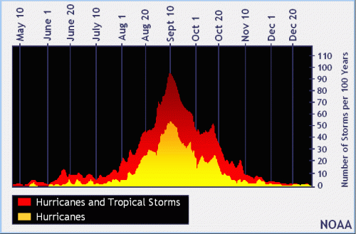
Distribution of tropical storms and hurricanes by date in last hundred years.Source: NOAA.
The tropical wave that moved onshore yesterday produced 2 to 4 inches of rain over League City this morning.
Meanwhile, two more storms are stacked up out in the Gulf and Atlantic. (See below.) The National Hurricane Center gives the orange one a 40% chance of developing and red one a 90% chance in the next five days.
Source: National Hurricane Center as of 3PM Tuesday 7/21/2020.As of 6:30 PM on 7/21/2020 the NHC has upgraded the central Atlantic Storm to a tropical depression, likely to enter the Caribbean this weekend. Source: NOAAOne model has the storm building into a hurricane. However, most don’t at this time. The intensity forecast for days 4-5 is low confidence according to Jeff Lindner, Harris County meteorologist.
Tropical Wave Likely to Arrive Friday
NOAA says that a tropical wave currently over Cuba is producing a large area of disorganized showers and thunderstorms over western Cuba. NHC expects this system to reach the northwestern Gulf on Thursday and Friday. Tropical formation chance currently equals 40 percent.
Jeff Lindner, Harris County meteorologist, says, “Regardless of development, widespread showers and thunderstorms will begin to impact the upper TX coast as early as late Thursday evening. More likely the impact will be Friday and lasting into Saturday. Some of this rainfall will be heavy. Winds will increase into the 15-25kt range with seas building to 3-5 feet by late Thursday and likely higher on Friday.”
Here’s how it all looks on the GOES-East satellite imagery in earth colors. Note the system about to enter the Gulf and the steady stream of clouds rolling off the western coast of Africa and across the Atlantic.
Note clouds over western Cuba and another mass starting to spin in mid-Atlantic.Closer shot with land masses outlined.
I nicknamed the steady stream of clouds “the rain train.”
Trade Winds Powered Global Commerce for Centuries
Technically, though, they’re called the trade winds. The term has an interesting origin. For centuries, they powered trade between Europe and the Americas. This time of year, sailors from Europe heading to the Americas would first sail south to Western Africa. There, they would pick up the trade winds (visible in the photos above) that powered them west.
After completing their trade, they would head north along the Eastern Coast of the U.S. and pick up a return flow that would take them back to Europe.
It was a reliable, but often deadly route.
Of the 691 ships identified by the Spanish researchers that were lost between between 1492 and 1898, 91.2% were sunk by severe weather – mainly tropical storms and hurricanes.
There’s an island off the coast of Honduras called Guanaja. The Spanish called it Isla de Los Pinos. Isle of Pines. It’s one of the few islands in the Caribbean with native pine trees. Columbus visited there on his fourth voyage. And according to local legend, Spanish sailors would often stop there after crossing the Atlantic to replenish their masts.
Posted by Bob Rehak on 7/21/2020, updated at 6:30 pm with info on TD7.
1057 Days since Hurricane Harvey
https://i0.wp.com/reduceflooding.com/wp-content/uploads/2020/07/Atlantic-Geocolor.jpg?fit=1200%2C1200&ssl=112001200adminadmin2020-07-21 16:30:422020-07-21 18:32:15Get Ready for the Rain Train
Small part of an estimated 15 acres still without vegetative cover.Photo taken 7/19/2020.
Moreover the company still has not removed rusting equipment.
Excavator and fork lift parked near entranceon 7/19/2020
13 Previous Investigations
TCEQ investigated the plant 13 previous times in the last five years.
The Texas Concrete Plum Grove Plant was already part of an active enforcement case (#57254) due to an unauthorized discharge and for failing to meet final stabilization requirements before terminating coverage under the Texas Discharge Pollutant Elimination System (TPDES).
Final stabilization requirements include the planting of “vegetative cover” to retard erosion before abandoning the site. Texas Concrete ceased operations at the site and pulled down its signs. However, approximately 15 acres of the site remain unplanted; they have no vegetation.
According to the TCEQ report, the company claims it planted grass, but the grass failed to establish. A company spokesperson was not available for comment.
The definition of final stabilization is as follows: “All soil disturbing activities at the site have been completed and a uniform (e.g. evenly distributed, without large bare areas) perennial vegetative cover with a density of 70% of the native background vegetative cover for the area has been established on all unpaved areas and areas not covered by permanent structures, or equivalent permanent stabilization measures (such as the use of riprap, gabions, or geotextiles) have been employed.”
TCEQ did not respond to a request for an explanation of how it measured 70% of the native background vegetative cover. Background vegetation is this case is a dense pine forest, not grass.
Rusting Equipment Allegedly Sold, But Still on Site
The company also seemingly abandoned rusting equipment on the site. The equipment includes a dredge, excavators, front loaders, dump trucks and trailers. Since the TCEQ’s followup investigations in June 2020, the company removed several dump trucks, but the vast majority of the other equipment remains – despite assurances from the company that it had all been sold. Neither the TCEQ, nor Texas Concrete has volunteered when the company will remove the equipment.
Weeds growing around tanker testify to how long it has remained there.7/19/2020Dredge still on site as of 7/19/2020Cyanobacteria have taken over some of the ponds at the abandoned Texas Concrete Mine. 7/20/2020. The pond was not tested for cyanotoxins.
No Additional Leaks Found
There is some good news from the latest investigation. Texas Concrete plugged previous breaches in its dikes. The investigator did not find any new unauthorized discharges, or discharges that failed to meet water quality specs.
Approaching Peak of Hurricane Season and Year Wasted
Still, three tropical disturbances making their way across the Atlantic at this moment make a stark reminder of why abandonment requirements exist. This site has sat unused for approximately a year. That should have been plenty of time to establish grass at a minimum and to restore this site.
Texas Concrete brags that it is a member of TACA and that TxDoT is one of its customers.
If the State of Texas is serious about enforcing environmental regulations, now would be a good time to start. And this would be a good place.
The only thing that separates neighborhood kids from playing in the sand, climbing on the equipment, and swimming in the colorful water. The security guard sign is a bluff.
Posted by Bob Rehak on 7/20/2020
1056 Days after Hurricane Harvey and 305 since Imelda
The thoughts expressed in this post represent opinions on matters of public concern and safety. They are protected by the First Amendment of the US Constitution and the Anti-SLAPP Statute of the Great State of Texas.
https://i0.wp.com/reduceflooding.com/wp-content/uploads/2020/07/20200719-DJI_0178.jpg?fit=1200%2C900&ssl=19001200adminadmin2020-07-20 16:51:282020-07-20 16:56:23TCEQ Complaints Against Texas Concrete Plum Grove Plant Still Unresolved
Hopefully, by now, regular readers of this website should know all about FEMA’s National Flood Hazard Layer Viewer and be able to identify whether they are in a recognized flood zone. But fully understanding flood risk can be far more complicated.
In a heavy rain, will water run toward or away from your home? Exactly how far below the 500-year flood plain is a given location? When water at a river gage reaches X, how much water will you be standing in at Y?
Every week, people alert me to new online tools that help assess different aspects of flood risk. Last week, I learned about three.
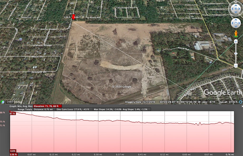
Elevation Profiling in Google Earth Pro
One is actually a feature within Google Earth Pro called “Elevation Profiling.” Many parts of Houston are so flat, it’s often hard to tell with the naked eye whether your home is at the high point or low point in your neighborhood. Which way does the land slope? How steep is the grade? What are the average and maximum grades? These are all good things to know if you want to make sure you don’t buy at the bottom of a bowl or waterfall.
From the NW corner of Woodridge Village to the home on Right Way, the elevation dropped approximately 16 feet. The average slope is 1.4%.
Elevation dropped 15 feet along the eastern border of Woodridge, 12 feet along the western border and 3 feet from west to east along Taylor Gully. No matter which way you look at it, everything on Woodridge sloped in their direction.
To use this feature in Google Earth Pro:
Select the Path tool.
Define a path. It can contain multiple points. For instance, you might want to trace the elevation along street that curves.
Highlight the path in the side bar.
In the Edit menu, select “Show Elevation Profile.”
The red box will then appear at the bottom of the screen with the profile and related information.
Running your cursor across the elevation profile will highlight the corresponding point on the satellite image and show you its elevation, distance from the start, and grade from the start.
Houston Public Works offers a variation on FEMA’s floodplain maps. It shows you in one foot increments how far below the 500-year floodplain (the City’s new benchmark for building) you are at any given location in the City. Are you barely in it? Or more than five feet below it? Knowing the answer can help you assess how much risk you’re taking on when you buy a new home. Said another way, it gives you much more detail.
National Weather Service Inundation Viewer
Want to know how deep the water will be in your home when a river gage near you reaches a certain level? This is the tool for you.
Gage is at the green marker. Click on any point in the blue, and it will tell you how deep water will get at that point for a selected gage height (left).
Start by clicking on Inundation and a gage height in the left hand column. As you click on different levels, watch the floodwaters expand or contract. (This shows the extent of floodwaters when the gage is at 66 feet.) Then click on another point within the floodwaters. A pop up box tells you how deep the floodwater will get at that location.
As you click on different gage heights in the left column, watch the water increase or decrease within the pop up box. At a gage height of 78 feet, people at the red dot could expect to be under 12 to 14 feet of water.
Locate your gage then click on Inundation in the left column.
Next, select a level of flooding.
Within categories (Minor, Moderate, Major), you can select one foot increments.
Then on the map, click on any other nearby location.
Within a pop-up box, it will tell you how much water you can expect for any given gage height.
This information will be useful in deciding when and whether to evacuate. For instance, clicking on a bridge will tell you at what point it goes under water.
Clicking on other tabs, will show you hydrographic and probability information, and more.
I look forward to the expansion of this powerful tool to other gages.
Posted by Bob Rehak on 7/19/2020
1055 Days after Hurricane Harvey and 304 after Imelda
https://i0.wp.com/reduceflooding.com/wp-content/uploads/2020/07/Innundation-A.jpg?fit=1200%2C762&ssl=17621200adminadmin2020-07-19 20:33:212020-07-19 20:53:13Three Online Tools To Help You Better Understand Flood Risk
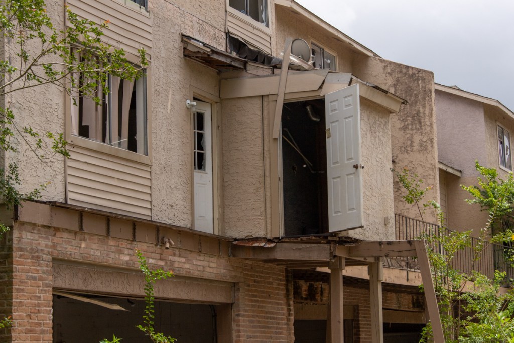
This is the story of a first responder who helped rescue dozens of families during Harvey. His own home later flooded during Imelda. Then he was the one calling for help. But that’s just the start of this gripping story. A house he rented (next to Woodridge Village) had flooded months earlier in May 2019, but Camillo Properties, the management company, said it had not. Within days of moving in last September, it flooded again. And that was after being in the emergency room most of the previous night with his stepson, who was diagnosed with pneumonia. Then the management company sued him for non-payment of rent – which he had paid. You don’t want to stand next to this guy in a lightning storm. Despite all his troubles, though, he says his relationship with his fiancé is stronger than ever. For job reasons, he needs to remain anonymous. I will refer to him only as John.
Rescue of Friend Turns into 12-Hour Marathon
Rehak: You had worked for a fire department in Montgomery County before Harvey. During the storm, you got a call from a terrified friend in the Barrington who was trapped in rising floodwaters. Tell me what happened.
John: Six to eight hours before calling me, she posted to Facebook saying she was in her living room, watching a movie, sipping wine, and “Everything is normal.” Then she called at 2 a.m. asking if I had any contacts who could rescue her.
Every back-channel contact was overwhelmed. So, I went down there in my Jeep to see if I could make it in. When I arrived, it was a lot deeper than I thought. Then a gentleman showed up with a huge aluminum boat – the kind that HFD uses for water rescues.
He said, “Hey, I’ve got a couple of friends back here, too. Let’s go see what we can find.” This was just before dawn. We got everyone into the boat. Then we started looking and realized, “It’s not just a few people who didn’t evacuate.” There were hundreds upon hundreds back there.
That’s about when rescue organizations started showing up. Eventually, there were dozens of boats pulling people out.
Rehak: How many times did you go back in?
John: I couldn’t say. But I didn’t leave till about four that afternoon.
Rehak: You evacuated people for 12 hours!
John: We had to stop when we ran low on fuel.
Rehak: Could you estimate the speed of the current in the Barrington?
John: No. But I’ll tell you that it got real hairy, real quick, even with a 150 horsepower motor.
Delayed Emotional Impact and Navigating Hidden Dangers
Rehak: What was it like emotionally as the day wore on?
John: After the fact, it was like…”Holy crap! How many people just lost everything that they had?” But at the time, we were too busy to think about it.
Coast Guard Rescue in Barrington filmed by Johnduring boat rescue.
John: Coast Guard Seahawks were doing hoist rescues in areas boats couldn’t get to. And we were dodging submerged obstacles. We hit a couple of communal mailboxes. Those aren’t typical hazards you think about when operating a boat.
Rehak: Were there any other dangers that made things hairy?
John: Desperate people. Many weren’t thinking clearly. Some families didn’t want to leave, including those with kids.
Rehak: Were they in two-story homes?
John: Yes. But they had no access to resources past the initial push. Food, fresh water, working toilets.
Rehak: It was unsafe.
John: And water was creeping up to power meters. CenterPoint had not yet killed the area.
Rehak: Were there cars under water, too?
John: Oh, yeah. You could barely see the tops of some.
Rehak: Any other stories stand out in your mind?
John: Some families with kids had to make decisions about who would get in the lifeboat first and who would stay behind. It was heartbreaking.
“No. No. No. That House Never Flooded”
Rehak: Let’s talk about YOUR flood experience now in September of 2019 during Imelda.
John: We had been leasing an apartment at the front of Kingwood. The lease was coming up for renewal. So, we started looking at houses to lease and found one in North Kingwood Forest. It looked brand new even though the neighborhood was several years old. Looking back, that should’ve been a red flag.
Camillio owned many properties on the street where John lived. Photo taken 12/22/2019, after homes had been repaired from Imelda on 9/19/2019.
Rehak: What attracted you?
John: It had more space. It was affordable, and there were many young families with kids. We applied, were approved within a couple of days, and set a move in date. As luck would have it, that turned out to be just SEVEN days before Imelda.
Rehak: Your pictures looked as though you weren’t even fully unpacked when the flood hit.
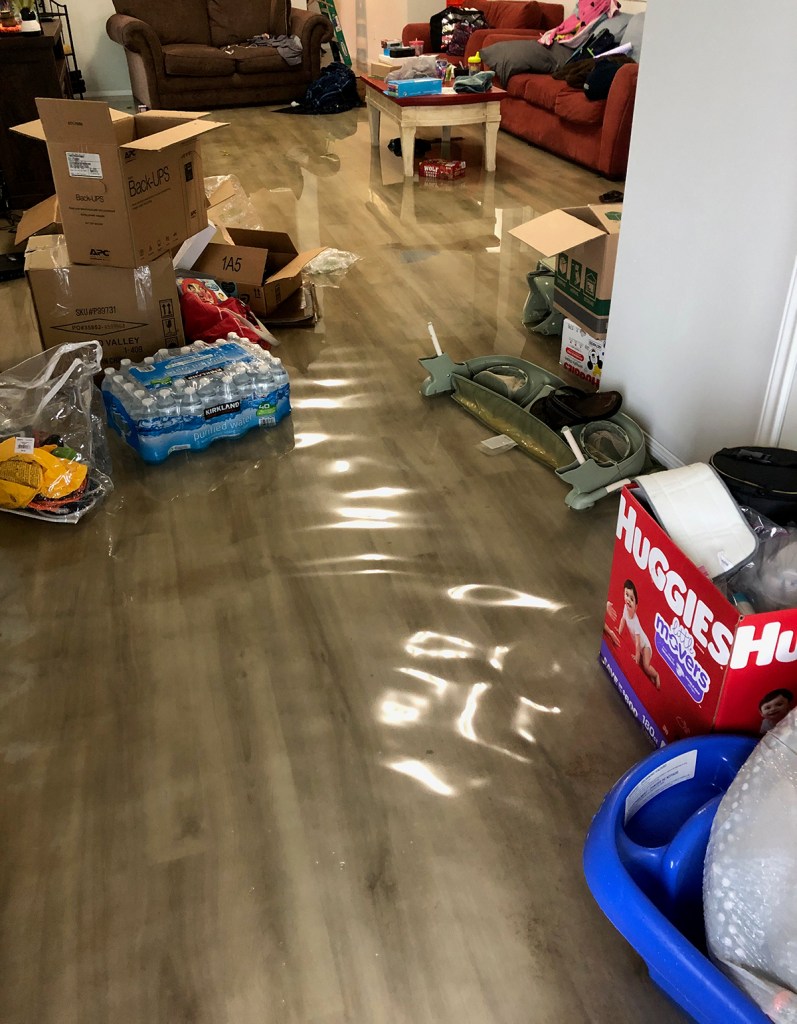
Still unpacking after move when flood hit.
John: We had only unpacked essentials. And we had just done a big Costco run with cases of water, six-packs of chili, everything you need to stock a pantry. And then…
Rehak: Before you signed the lease, did you ask whether this place flooded before?
John: Unfortunately, we asked just after signing. My dad talked to our neighbor next door when we were moving in. She asked him whether they told us that the house had flooded in May.
View of street from John’s garage during Imelda
Rehak: Surprise!
John: So, I called the landlord and asked, “Did that house ever flood?” I was told, “Oh, no, no, no. That never flooded. Only the other side of the neighborhood flooded.”
8 days after the flood
Relocation to Spring Triggers Landlord Lawsuit
Rehak: Did that become a point of contention between you and the owners?
John: Not immediately. The landlord offered us another place in Spring. It seemed like they were trying to be accommodating. So, I didn’t really call out their lie at the time.
Rehak: What happened later to change your mind?
John: Towards the end of October, beginning of November, we got a letter from them saying that we had not paid our rent at the Spring location. Of course, we had, so I called them and said, “Hey, this is an error.” I sent them copies of bank statements showing the rent payments cleared. We had even paid through their online portal. They said, “OK, we’ll look into it.”
Fast forward, two weeks later, a Constable serves us with an eviction lawsuit. This was a couple months after losing 70 percent of everything we owned.
Rehak: What did you do?
John: I contacted an attorney friend and he began calling them. They fed him the same line, “Oh, we will need to look into it.”
My attorney called me two days before court and said, “I have not gotten any response from them. We’ll have to go to court.”
There, we met Camillo’s representative from Nationwide Evictions. We showed her our bank statements. But their paperwork showed only a move in and then nothing being paid. The judge found our evidence overwhelming and ruled in our favor. That was the end of that. But it left a sour taste.
At that point, I thought to myself, “As soon as our lease is up and we can get away from this management company, we’re going to.” And we did.
Impact on Relationship
Rehak:. You have a fiancé who is a paramedic. How did this affect your relationship?
John: I tell people, “After two moves in 10 days, on top of a flood, you’re either going to split up or you’re going to last a lifetime. We’re still together!
Trip to Emergency Room Night Before Imelda
John: To top it off, the night before Imelda, he developed pneumonia. We were in the Kingwood Emergency Room with him until the wee hours. Fast-Forward to 9:30 or 10 the next morning. My fiancé woke me up and said, “We’re flooding.”
View out front door when John woke up.
Rehak: What went through your mind?
John: I felt this has got to be a nightmare. That’s what she told to me later – that I rolled out of bed half awake and said, “This has got to be a nightmare.” Then I stepped down into water. That woke me up real fast!
Water flowing between John’s house and neighbor’s during Imelda.
From Pneumonia to “Water Park”
John: You’d think my stepson would have been sad or scared. But like a typical 4-year old, he thought it was a freakin’ WATER PARK! I can’t help but think that contributed to his pneumonia. It took him two weeks to get over that. There were a lot of sleep-deprived nights for us. We were mentally drained.
Rehak: So, on top of the flood, you’ve got a sick kid during your second move in two weeks! How did the people at your workplace react?
John: They came together. I have to say. They gave me time off work. They established a “go fund me.” Financially, they took care of us. They did right by us.
“Start Taking Out Fence Pickets”
Rehak: Tell me more about what happened during the Imelda flood after you woke up.
John: We reached out to family and friends and started stacking things on couches, countertops, anything to get stuff up off the floor. Then we called Camillo and said, “We are actively flooding. What do we do?”
She said to start taking out fence pickets to allow the water to flow around the house versus through the house. That’s when I suspected that they knew this house had a tendency to flood. Otherwise, why would you say, “Take out fence pickets”?
Fence slats removed from neighbor’s house in May 7th flood. Photo taken May 24, 2019.
Water Coming From Back, Not Street
Rehak: Your video shows water flowing quickly from the back yard toward the street. How deep was the water in your back yard?
John: About a foot above my knees. It was that much higher in the back than on the street side. There was sand and silt throughout the house after the water receded.
Sand and silt in garage as flood receded.
Rehak: That didn’t come from the street.
House where John lived in relation to Woodridge Village construction in background. Photo taken 7/15/2020. Note fence repairs. Every home in this photo flooded.
John: Nope. There was only one place it could have come from.The 268-acres they had just cleared next to us.
Woodridge Village on 11/4/2019. Arrow shows approximate location of John’s home. In this photo you can feel the slope in the land that funneled water toward Taylor Gulley behind the twin culverts near the far tree line.
Posted by Bob Rehak on 7/18/2020
1054 Days after Hurricane Harvey
The thoughts expressed in this post represent opinions on matters of public concern and safety. They are protected by the First Amendment of the US Constitution and the Anti-SLAPP Statute of the Great State of Texas.
https://i0.wp.com/reduceflooding.com/wp-content/uploads/2020/07/IMG_7350.jpg?fit=1200%2C900&ssl=19001200adminadmin2020-07-18 07:45:222020-07-19 20:12:43The First Responder During Harvey Who Flooded During Imelda
It’s a minor victory. And it may not actually change anything on the ground. But the City of Houston today sent a signal to developers, who now have to identify flood prone areas on their general plans.
The move should eliminate any doubt among bankers, buyers and real estate agents as to whether a particular property is in a floodway or flood plain.
By following all the other guidelines, developers can still get their plans approved. This change helps people seeking truth and full disclosure in the sales process.
There’s one other key change. Another new requirement is that, as each section of a general plan is platted, it has to adhere to the then current standards. That is important so that the entire development isn’t grandfathered by the approval date of the general plan.
These changes may make some developers think twice about buying and developing flood-prone property. Especially if they target unknowledgeable buyers, such as young people or foreigners, who may be unfamiliar with American flood standards.
Today’s press release by the City of Houston’s Planning and Development department says the changes will go into effect July 24, 2020.
The release is being blasted out to developers also. It’s titled “Platting Updates for Flood Prone Areas.” I have reprinted the full text verbatim below.
IDENTIFICATION OF FLOOD PRONE AREAS ON GENERAL PLAN
Effective July 24, 2020
Flooding events have been increasingly severe in the City of Houston and our region. The 2018 amendment to Chapter 19 City of Houston Code of Ordinances mandated that it was necessary to evaluate development within the 100-year and 500-year floodplains to protect investments made by residents and business owners in real property within the City. Harris County and others have developed their own needs in improving the drainage in their regions.
To mitigate and reduce the risk of flood loss for future development, the 100-year, 500-year floodplains and floodway will be required to be identified on all General Plans submitted to the Department with the Plat Tracker application. Applicants will be required to graphically depict the location of the floodplains and or floodway on their General Plans and provide related note.
This information must be provided as part of initial submittal of a General Plan for Planning Commission consideration. The General Plan application will be marked incomplete if this information is not included as part of the initial submittal.
HOW TO ILLUSTRATE
The way to depict this information correctly is to go to the FEMA website through the following link: https://msc.fema.gov/portal/search#searchresultsanchor.Enter the address, place, or coordinates. The site will produce a map that will identify whether the property is located in the 100-year, 500-year flood plains or floodway. Provide a dashed line on your General Plan identifying the 100-year, 500-year flood plains or floodway as depicted on the FEMA map.
GENERAL PLAN RELATED NOTE
Also, include on the face of the General Plan the following related note as follows: Portions of the property included in this General Plan lie within the known floodway and the 100 and 500-year floodplains. As each section or parcel is platted and developed, the then-current standards of City of Houston [or if ETJ: Harris County] drainage, elevation, and building regulations must be adhered to.
For additional information contact Dipti Mathur at 832-393-6560.
Imagine how the general plan of “Orchard Seeded Ranches” would look. It would clearly show that virtually every property was subject to severe flooding. Also imagine now how those new townhomes in Kings Harbor will look to Chinese investors.
Developers who specialize these types of distress properties may have to rethink their marketing strategies.
Posted by Bob Rehak on 7/17/2020
1053 Days since Hurricane Harvey
https://i0.wp.com/reduceflooding.com/wp-content/uploads/2020/07/Screen-Shot-2020-07-17-at-4.56.38-PM.png?fit=810%2C404&ssl=1404810adminadmin2020-07-17 17:12:202020-07-18 06:48:48City of Houston Will Now Require Developers to Identify Flood-Prone Areas on Their General Plans
Note: the post below was condensed and adapted from a longer USGS article. The U.S. Geological Survey (USGS) records continuous stream stage (height of a river) and streamflow (how much water is flowing) with thousands of gages throughout the nation. But how can they determine flood height where no gages exist?
Simple, USGS correlates high water marks after floods with peak gage heights during floods.
“If, for example, records show that stream stage reached 17 feet during a storm, a high-water mark will show the hydrologist what a stage of 17 feet means in terms of how high the water was on the riverbanks and surrounding land.”
Finding high water marks on or near buildings is easy. You look for the mud line or the edge of debris fields. The same principle applies in nature. Sometimes it’s easy.
Think of high water marks like a bathtub ring around a flooded area. Shown here: East End Park after Imelda.
But they’re not always that obvious.
Can You Spot High Water Marks In Pictures Below?
Below are two pictures used by USGS for demonstration purposes. They took the pictures a few days after a record storm. High-water marks show in both pictures, although a hydrologist would only regard one of the marks as being reliable.
Spot the high water marks.
The pictures below are close-ups of the high-water indicators in the top pictures. Did you spot them?
The left picture shows a poison ivy vine with the bottom leaves covered in dried mud. Where the mud stops shows how high the floodwaters reached.
The right-side picture shows a limb that hangs over the same creek. During a flood, rapidly-moving water carries leaves and pine needles, etc.! They stick on limbs that are partially submerged. When the stream recedes the signs remain. The top of the leaves and pine straw indicate how high the creek was during the storm.
The mud on the vine is a much better high-water mark than the tree limb, though. During high water, the fast-moving water will cause partially submerged limbs to move up and down. Therefore, hydrologists would not use the limb to estimate high water.
How High Water Marks Are Used
Planning Development
Documenting high water marks helps plan development near floodplains. If you know that water reaches a certain mark on the bank every few years, you certainly don’t want people building homes and businesses there.
Determining Extent and Severity of Flooding
Gages can determine the height of a flood. But high water marks can also show the width and extent relative to topography.
After most major flood events, USGS partners with FEMA and other state and federal agencies to flag and survey high water marks in areas that flooded. USGS did so here after Harvey to determine the extent and severity of the flooding.
Prediction of Future Floods
Forecasters can use the data associated with high-water marks to predict the severity of future floods, delineate flood zones, and update current maps that may account for changes in upstream conditions.
Flood Frequency Calculations
High-water mark data is also part of the flood-frequency (or recurrence interval) calculations that FEMA uses to identify areas that are likely to experience a 1 percent chance of happening in any given year. These floods, known as 100-year floods, serve as the foundation for flood management planning.
Inundation Mapping
Another significant use: Flood-Inundation Mapping. A flood-inundation map shows the extent and depth of flooding that occurred in various communities as a result of a major storm or flood event. Inundation maps help determine things like:
Changes needed in building codes
Evacuation routes
Heights of bridges and roads.
Once inundation maps are complete, USGS documents them and makes them publicly available online.
Recreating Data from Damaged Gages
If a flood knocks out a gage, as it did with the one at US59 bridge and the Kingwood Country Club on the San Jacinto West Fork, high-water marks can provide maximum height of a flood after the fact. If the cross section of the river is known (or surveyed), hydrologists can even back-calculate the flow rate.
Posted by Bob Rehak on 7/16/2020 with thanks to USGS and Diane Cooper
1052 Days after Hurricane Harvey and 301 since Imelda
https://i0.wp.com/reduceflooding.com/wp-content/uploads/2020/07/20170915-San-JacintoRJR_3366_308.jpg?fit=1200%2C800&ssl=18001200adminadmin2020-07-16 19:57:082020-07-16 20:23:08How High Water Marks Help Fill Gaps in Flood Knowledge
Almost 40 years ago, when I moved to Houston, I fell in love with the extraordinary beauty of this City. And nowhere in Houston is more beautiful than the Lake Houston Area. The pictures below show why it’s worth fighting for.
Nature in the Lake Houston Area isn’t a place you go to visit. You don’t have to drive or fly to it. It’s all around you. Step out your back door and you’re already there. You’re breathing it. You’re being it.
Harvey Was an Eye Opener
Right up until Hurricane Harvey, I felt, on balance, this was the most perfect place in America to raise my family. Houston offers career opportunities found in few other cities. And the Lake Houston Area, in particular, offers the things my family and I value.
Harvey didn’t change my mind about those things. But it did open my eyes to some things I should have paid closer attention to. All around us, that perfect environment was quietly and steadily being eroded for decades.
It’s not gone. But it is threatened. Every day. More than a thousand other posts on this web site amply chronicle those threats. I won’t dwell on them here. Nor will I dwell on how “the greatest flood ever” kept being replaced by the new “greatest flood ever.”
What We Need to Fight For
I would like, instead, to share several images that show it’s not too late to preserve what we have. But to do that, we have to fight for it.
We need to fight for:
Responsible aggregate mining.
Better development practices that respect nature.
Upstream floodplain regulations that reduce flooding.
Flood mitigation efforts that keep the 100-year floodplain a 100-year floodplain.
Why We Need to Fight
I took all of the pictures below in the last three months. They show what we need to save. All were shot inside America’s fourth largest city, which makes them even more unique.
The Kingwood Country Club’s Lake Course.Can you spot the thousands of homes around it?West Fork of the San Jacinto with Lake Houston on the horizon. Looking SE.For decades, development preserved nature.This is the result.Looking north at Lake Houston across the spillway.Looking south over the Lake Houston Dam toward the industry that powers America and the world.Looking east from the West Fork toward the East Fork of the San Jacinto with Royal Shores between them.Looking north along the East Fork. Kingwood’s East End Park is in the center and Huffman is on the right.Looking SE. FM1960 cuts across Lake Houston and through Huffman in the foreground Looking Southwest in the opposite direction from over FM1960, with Lake Houston in background.Looking East across FM2100 and Huffman toward Kingwood on the other side of the lake.Looking West. The Luce Bayou Interbasin Transfer Project where it enters into Luce Bayou and the headwaters of Lake Houston.Looking north from the Commons on Lake Houston toward where the new Grand Parkway is circling Houston (out of sight) near the top of the frame.This entire area could soon be developed.Looking southeast across Kingwood Park High School. Kingwood, where 70,000 people live, is almost invisible, hidden among the trees between the school and Lake Houston at the top of the frame.Looking north over Forest Cove, toward I-69 and Insperity, Kingwood’s $4 billion company, all hidden in the trees.Looking NW from the confluence of Spring Creek and the San Jacinto West Fork.All of this land has been bought by a developer.Fishing from your back door.
If this isn’t worth fighting for, I don’t know what is.
Bob Rehak
Please join the fight. There’s another legislative session starting in six months.
Posted by Bob Rehak on 7/15/2020
1051 Days since Hurricane Harvey
https://i0.wp.com/reduceflooding.com/wp-content/uploads/2020/07/20200616-RJR_3539.jpg?fit=1200%2C800&ssl=18001200adminadmin2020-07-15 21:33:202020-07-15 23:00:01Worth Fighting For
How do we break the process of building in floodways and then repairing flooded homes with taxpayer-subsidized flood insurance as many as forty times?
A 66-page study by Erica Vilay and Phil Pollman, two candidates for Masters Degrees in Public Policy from Harvard, examines the broken buyout process for flooded homes in Houston floodways. The study also makes recommendations to improve the process. But they won’t revolutionize it. And that may be what this process needs.
The merit in this study is that it takes a holistic view of buyouts and examines them as one of many alternatives available to flood victims living in floodways. From the public’s perspective, buyouts have unquestionable and compelling safety and financial benefits.
Buyouts produce $7 in benefits for every $1 invested. And they take people out of harm’s way.
Speedier Options Available to People In Time of Need
But the process is slow. People have options. And, according to the study, they almost always prefer those other options. In fact, the rate of buyouts is so slow that it will take the City 60 years to meet its 10-year objective, claim the authors.
The paper cited one property that had been repaired a record 40 times. So why is it so difficult to get people to move out of a floodway into housing that won’t jeopardize their lives or lungs?
Vilay and Pollman examine the reasons. The incentives, they say, all favor rebuilding or selling to developers rather than accepting government buyouts.
Tax-subsidized National Flood Insurance Policy premiums remain affordable, offset risk, and usually reimburse homeowners within 60 days after a storm.
Selling to a developer/investor can happen within days or weeks.
Consummating a buyout through the maze of Federal, State, County and Local government agencies can take years.
Federal funding is slow, inflexible, and extremely complex to manage effectively and efficiently.
At the current closing rate, it would take nearly 60 years to buy out the 7,000 habitable structures in Houston floodways, says the study. But Houston-area realtors sell that many homes in a typical MONTH, according to the Greater Houston Partnership! Even in the middle of a pandemic.
“This is a No Brainer”
So one of the big reasons people are reluctant to be bought out is speed. Their lives have just been destroyed in a flood. They need a place to live. Then along comes the government saying, “Let me buy you out. I’ll get you your money in 2-3 years. Or you can just repair your home for the fortieth time and we’ll pay for it immediately.” This is a no-brainer, say the authors.
How hard are buyouts? The authors claim that “As of January 2020, HCFCD has used $3 million out of a $10 million bucket of federal funding allocated to the City for flood events that occurred in 2015.”
Barriers Beyond Slowness
But degree of difficulty and process slowness aren’t the only reasons people shun buyouts.
People get attached to neighbors and neighborhoods.
They may have family living nearby.
There may be a shortage of affordable housing elsewhere.
Alternative housing may be farther from their work.
They may want to stay within a school system.
Goals: Slow Inflow, Speed Outflow
The authors define two goals. They say we need to:
All of these recommendations are solid and, to a large degree, self-explanatory. They are hard to quibble with if you are trying to improve a process.
Incremental Improvements vs. New Concept
The authors never really address, however, whether incremental improvements will achieve the stated goals. Or whether we need to nuke the process and start over with a revolutionary, new concept.
As I read this study, I kept wondering what Steve Jobs, Jeff Bezos, or Elon Musk would recommend. That’s a pretty steep burden to impose on grad students. But we shouldn’t forget that Fred Smith had the idea for Fedex while still a student at Yale.
Each of those people made the world a better place by designing new products or services that leapfrogged incremental improvements in existing systems and made the old way obsolete.
Inside-the-Box Thinking for an Outside-the-Box Problem
Insi-e the-box thinking will certainly produce incremental improvements. But in the estimated time it will take government to buy out 7,000 homes, Houston realtors will sell more than 5 million. That’s 70,000% better. Which would you rather have in your employ?
So I would ask these questions. What if you:
Privatized this process?
Offered flood victims an “instantaneous home SWAP” as they were ripping out sheetrock?
Made flood insurance reflect its true cost?
If ever there was a need for “business process re-engineering,” this is it.
Posted by Bob Rehak on 7/14/2020 with appreciation and admiration for Erica Vilay and Phil Pollman
1050 Days since Hurricane Harvey
https://i0.wp.com/reduceflooding.com/wp-content/uploads/2020/07/20200627-RJR_0059-1.jpg?fit=1200%2C800&ssl=18001200adminadmin2020-07-14 18:18:182020-07-14 20:23:45New Harvard Study Examines Barriers to Buyouts; Will Process Improvements Be Enough?
In a court document filed today, Perry Homes LLC has answered Elm Grove flood victims and says the damages suffered by flood victims were their own fault.
Last month, lawyers for flood victims named Perry Homes LLC as an additional defendant. (Previously, only Perry’s subsidiaries and contractors had been named as defendants.)
Perry Homes is asking the Court to enter a judgment and let the Plaintiffs take nothing. The company claims plaintiffs’ allegations are not true and has issued a general denial.
In addition, Perry claims that:
Plaintiffs’ damages are a result of pre-existing conditions.
Damages resulted from an act of God.
Damages resulted from independent causes for which Defendant is not legally responsible
Damages were caused by acts, omissions, or negligence of third parties over which Defendant had no control
Plaintiffs shared the fault and therefore Perry shouldn’t be held wholly responsible.
Plaintiffs claims should be barred because Perry acted with care and complied with all laws.
Plaintiffs’ claims should be barred because plaintiffs somehow failed to mitigate their own damages (presumably decades before the damages occurred).
Plaintiffs have not fulfilled all conditions necessary to maintain the lawsuit.
Plaintiffs’ recovery, if any, should be subject to the one-satisfaction rule. (Under Texas law, the one-satisfaction rule states that a plaintiffs can only recover damages once. For instance they can’t recover total damages from Perry and then again from LJA Engineering, which was also named as an additional defendant).
Plaintiffs’ claim for pre-judgment interest is limited by the dates and amounts set forth in Chapter 304 of the Texas Finance Code. (The law specifies that the prejudgment interest rate is equal to the post-judgment interest rate applicable at the time of judgment. It also specifies that interest may not compound and when interest charges may start.)
Again, even if they are at fault, Perry should not be fined for exemplary or punitive damages. Exemplary and punitive damages, they claim, violate:
The Fifth, Sixth, Eighth and Fourteenth Amendments of the U.S. Constitution
Article 1, Sections 3 and 19 of the Texas Constitution
Due process and equal protection under the law
In regard to the last point, Perry Homes makes no mention of the laws that allow exemplary or punitive damages. Nor do they reference cases that point to standards of proof for exemplary or punitive damages.
Pleads “Further and In the Alternative” Thirteen Times
The lack of specificity in Perry Homes’ filing makes it difficult to decipher what the claims actually mean. However, Perry uses the phrase, “Pleading further, and in the alternative, and without waiving the foregoing…” 13 times. Basically that means, “If the judge or jury won’t buy X, we still reserve the right to plead Y.”
This is more than a shotgun defense; it’s a blunderbuss defense. But why would lawyers who get paid $1000/hour want to get to the point, tip their hand, or limit their client’s options?
Victim Blaming At Its Finest
There’s an undercurrent of victim blaming in much of Perry Homes’ points.
Perry subsidiaries have previously claimed that many Elm Grove homes were in the floodplain. Claiming victims should have somehow prevented flooding in homes that were built 40 years earlier – when they never flooded until Perry clearcut land immediately upstream from them – is the height of chutzpah.
I use that term in the sense of “brazenness” or “audacity.”
It’s like pleading that the shooting victim was at fault because he failed to get out of the way of the gunshot.
It ignores the fact that someone pulled a trigger. Collectively, Perry, its subsidiaries and contractors violated Section 9.2 of the Montgomery County Drainage Criteria Manual.
Section 9.2 states that “Pursuant to the official policy for Montgomery County, development will not be allowed in a manner which will increase the frequency or severity of flooding in areas that are currently subject to flooding or which will cause areas to flood which were not previously subject to flooding.”
Perry Homes’ victim blaming shows how Perry now thinks. Their bizarre logic – and the hollow claim that they followed all laws – explain a lot about why Elm Grove flooded. Perry today is a far cry from the company that Bob Perry founded in 1968.
Posted by Bob Rehak on 7/13/2020
1049 Days since Hurricane Harvey and 298 since Imelda
The thoughts expressed in this post represent opinions on matters of public concern and safety. They are protected by the First Amendment of the US Constitution and the Anti-SLAPP Statute of the Great State of Texas.
https://i0.wp.com/reduceflooding.com/wp-content/uploads/2019/09/Elm-Grove-9.19_68.jpg?fit=1500%2C1000&ssl=110001500adminadmin2020-07-13 16:51:432020-07-13 18:49:45Perry Homes Blames Elm Grove Flood Victims
Texans for Responsible Aggregate Mining (TRAM) is a statewide coalition of member groups seeking to work with lawmakers, state agencies, and good-faith industry operators. Their goal: to create state standards for best management practices in the rapidly expanding Aggregate Production Operation (APO) industry, and adopt those standards into law.
You can also visit the sand mining page or the index page of this web site to review information on APOs and sand mining specifically in the Houston region.
Posted by Bob Rehak on 7/13/2020
1049 Days since Hurricane Harvey
https://i0.wp.com/reduceflooding.com/wp-content/uploads/2020/07/TRAM-Counties.jpg?fit=1200%2C927&ssl=19271200adminadmin2020-07-13 12:14:442020-07-13 12:25:23Statewide Group Called TRAM Has Formed to Lobby for Responsible Aggregate Mining