The excavation rate of a sixth detention pond on Harris County Flood Control District’s (HCFCD) Woodridge Village property increased during the last month of 2022. That brought the total for the year to 73,745 cubic yards of soil removed under Sprint Sand and Gravel’s Excavation and Removal (E&R) Contract.
The reported total at the end of November was 67,529 cubic yards. That means the total for December was 6,216 cubic yards, the most for any month since last July. Compare the previous totals below.
Weekly totals through November
Excavation under E&R contracts varies depending on demand for fill dirt. Sprint’s contract with Harris County Flood Control District lets it take dirt basically for free and then sell the dirt on the open market to make its money.
The work could more than double the stormwater detention capacity on the site that flooded Elm Grove and North Kingwood Forest twice in 2019.
According to HCFCD, E&R agreements provide an opportunity for making progress in advance of future basin construction. These agreements essentially provide a head start in the excavation process before the detention basin is designed and constructed. In these agreements, an excavation company agrees to remove soil from a basin site during an agreed upon time period for minimal compensation. This is a cost-effective way for the material to be removed and it also provides significant savings by minimizing trucking and disposal fees.
Pictures Taken 1/03/23
Looking west toward the site entrance on Woodland Hills Drive.Contractors appear to be leaving some existing concrete culverts in place that will allow the new pond to drain into the old one at the top of frame.Looking NE. The pond could eventually extend as far as the grove of trees in the distance.
HCFCD expects that Sprint will excavate the full 500,000 cubic yards stipulated in their contract. That will expand the current stormwater detention capacity by 166%. The property only needed 40% more to meet Atlas-14 requirements. So this will provide a considerable margin of safety.
Other improvements include:
A concrete-lined, low-flow channel within the existing channel to expand conveyance from 350 feet downstream of Creek Manor Drive to 1500 feet downstream of Mills Branch Drive. The concrete portion would be four feet deep and 20 feet wide.
A new clear-span bridge at Rustling Elms to replace the current bridge over two culverts.
1955 Days since Hurricane Harvey and 1204 since Imelda
https://i0.wp.com/reduceflooding.com/wp-content/uploads/2023/01/20230103-DJI_0594.jpg?fit=1200%2C799&ssl=17991200adminadmin2023-01-05 11:53:522023-01-05 11:58:00Woodridge Village Excavation Rate Ticks Up
According to its new website, the controversial Laurel Springs RV Resort near Lakewood Cove plans opening in January 2023. Recent aerial photos show workers putting the finishing touches on the “resort.” Even though the City of Houston permitted 182 spaces, the website advertises 226.
The photos below show the status of construction on 1/3/2023. The portion closest to camera in the first shot, looks ready to go. But workers are still scurrying about the northern portion of the site.
Looking N from southern end of property.Plans for the park claimed only 66% impervious cover.Last remaining dirt work in NW corner of detention pond.That triangular space comprises the resort’s dog park. Dachshunds and chihuahuas fit in the narrow end.Trees planted just before Christmas will soon brush up against utility wires.Water still ponds in the area below where the resort buried pipes through the dike.
The permit plans stipulate that the site’s detention basin must have a dry bottom within 48 hours of a storm. It hasn’t had a dry bottom in quite a while.
The resort’s website calls the basin a “retention pond.” Retention ponds are designed to hold water permanently.
The Resort’s new typo-plagued website has about as much attention to detail as its permit applications did. RV owners can only hope they do better with invoices. See below.
A scrolling banner on the website trumpets the Resort’s marketing theme – “Join the Adventure.” It promises to be exactly that – an adventure…right next to the railroad tracks, which the owners forgot to mention.
Posted by Bob on 1/4/23
1954 Days since Hurricane Harvey
The thoughts expressed in this post represent opinions on matters of public concern and safety. They are protected by the First Amendment of the US Constitution and the Anti-SLAPP Statute of the Great State of Texas.
https://i0.wp.com/reduceflooding.com/wp-content/uploads/2023/01/20230103-DJI_0520.jpg?fit=1200%2C799&ssl=17991200adminadmin2023-01-04 11:55:042023-01-04 12:10:26Laurel Springs RV Resort Plans Opening This Month
After more than eight months of clearing, grading and drainage prep, The Residences at Kingwood, a 19.7 acre apartment complex on West Lake Houston Parkway between Upper Lake Drive and Kings Park Way, is finally under construction. The developer’s website says the complex will feature 240 Garden Apartments and 49 Townhomes.
The photos below show that carpenters have started framing buildings on the south end of the property and are working their way north.
Looking S. West Lake Houston Parkway on right. Upper Lake Drive in lower right.Closer shot of construction at south end of property.Detention basin seems to be functioning. Harris County specifies a minimum detention rate of .65 acre feet per acre for sites this large.
Although neighbors have complained of mud on West Lake Houston Parkway and surrounding streets, I have received no complaints of flooding yet.
Location
The map below shows the location of two parcels on West Lake Houston Parkway that comprise the new development. They are approximately halfway between the West Fork at the top of the frame and FM1960 at the bottom.
From HCAD.The cul-de-sac at the south end of the property (right)will be called Kings River Commercial Drive.
About the Developer and Project
The developer, High Street Residential, is a wholly-owned operating subsidiary of Trammell Crow Company.” In the last 15 years, High Street Residential has completed more than $2.7 billion with a current pipeline of more than 4,500 units.
The Residences at Kingwood will offer homes ranging in size from one to three bedrooms and will feature stainless steel appliances, in-unit washers and dryers, custom cabinetry, and nine-foot ceiling heights. Select units will also offer walk-in closets, private outdoor space, and one- or two-car garages. The development will feature:
A resort-style pool
Grilling areas
Fitness center with a yoga & Pilates studio, and an outdoor workout area
Resident lounge with an art gallery and an entertaining kitchen, along with a conferencing and remote-work suite
Pet grooming center
On-site storage
Putting green, bocce courts, pickle ball court
Multiple outdoor dining areas
Connection to the Kingwood Greenbelt trail system.
https://i0.wp.com/reduceflooding.com/wp-content/uploads/2023/01/20230103-DJI_0641.jpg?fit=1200%2C799&ssl=17991200adminadmin2023-01-03 14:25:382023-01-03 14:29:27240 Apartments, 49 Garden Homes Going Up on West Lake Houston Parkway
The problem: Changes affect both water quality downstream and land development upstream. That’s why the rules change so often. Competing interests! Public health and safety vs. economic expansion.
The Cuyahoga River caught fire a total of 13 times dating back to 1868. It is still rated one of the most polluted rivers in America by almost every group that compiles lists. Photo: Cleveland State University Library.
The photographers took about 81,000 images, more than 20,000 of which were archived. At least 15,000 have been digitized by the National Archives. They form a time capsule showing the way things were.
Warning: These images are disturbing…for people on both sides of the political net.
Why the Changes This Time?
The AP article by Jim Salter and Michael Phillis says, “The Trump-era rule, finalized in 2020, was long sought by builders, oil and gas developers, farmers and others who complained about federal overreach that they said stretched into gullies, creeks and ravines on farmland and other private property.”
However, the writers continued, “…the Trump rule allowed businesses to dump pollutants into unprotected waterways and fill in some wetlands, threatening public water supplies downstream and harming wildlife and habitat.”
They quoted Kelly Moser, Senior Attorney for the Southern Environmental Law Center’s Clean Water Defense Initiative. She said, “Today, the Biden administration restored needed clean water protections so that our nation’s waters are guarded against pollution for fishing, swimming, and as sources of drinking water.”
At Issue: Definition of “Waters of the U.S.”
Meanwhile, courts at various levels are still pondering the definition of “Waters of the U.S.” At issue: How far up in the branching structure of a river may the government enforce regulations? As far as it’s navigable? One level up from that? Two? Three? Infinitely? And do the rules apply to desert areas the same way they do to subtropical areas like SE Texas?
The Biden administration decision is a setback for various industries. It broadens which wetlands, streams and rivers can be regulated under the Clean Water Act.
But given the impacts to public health and the immense economic interests at stake, this won’t be the last time we see the rules change. An army of lobbyists is likely mobilizing right now.
Local Impact
Several developments in the Lake Houston Area contained wetlands affected regulation changes. Consider, for instance, the case of Woodridge Village. The Army Corps ruled that it contained wetlands, but that the wetlands didn’t fall under their jurisdiction because of rules in effect at the time. So there was no violation of the Clean Water Act. Hundreds of homes in Elm Grove and North Kingwood Forest flooded, partially as a result of the environmental destruction.
Confluence of Spring Creek and West Fork by 59 Bridge. TCEQ found that Liberty Mines discharged 56 million gallons of white waste water into the West Fork.Repeated and multiple breaches atTriple PG mine discharged sediment-laden water directly into Caney Creek. This one lasted for months.
Searching on the word “breach” in ReduceFlooding.com pulls up 116 stories, many of which show multiple breaches.
But mining isn’t the only upstream issue at stake. So is sediment pollution from new development.
Drainage ditch in Artavia.March 2020 in West Fork watershedEroding ditch in Colony Ridge (East Fork Watershed) due to lack of backslope interceptor systems and grass.
Making Private Expenses a Public Cost
The EPA lists sediment as the most common pollutant in rivers, streams, lakes and reservoirs. It has contributed to flooding thousands of homes in the Lake Houston Area.
West Fork mouth bar almost totally blocked the river where it meets Lake Houston.East Fork Mouth Bar grew 4000 feet in two years between Harvey and Imelda.
Both mouth bars above have since been dredged at great public expense, but abuses continue. I just wish we could all find a way to live together. This should not be a case of health and safety vs. economic development. We need all three for communities to prosper.
Posted by Bob Rehak on 1/2/23
1952 days since Hurricane Harvey
The thoughts expressed in this post represent opinions on matters of public concern and safety. They are protected by the First Amendment of the US Constitution and the Anti-SLAPP Statute of the Great State of Texas.
https://i0.wp.com/reduceflooding.com/wp-content/uploads/2019/11/RJR_4154-e1775771233982.jpg?fit=1100%2C733&ssl=17331100adminadmin2023-01-02 11:04:302023-01-02 11:49:14Biden Changes Trump’s Changes to Water Regulations
On November 21, 2022, the U.S. Government filed a 70-page motion for a summary judgment in the Addicks-Barker Downstream Cases. In 2020, Judge Loren A. Smith dismissed the downstream cases, ruling that the plaintiffs had no right to sue the government for “taking” their property in what he called a 2,000-year storm. However, in June 2022, a federal appeals court reversed Judge Loren’s decision, re-opening the case. The appeals court ruled on a number of procedural issues and remanded the case back to Loren’s court for further consideration.
Both appellants and the government had urged the appeals court to order a summary judgment. But the appeals court declined. It noted that “due to the fact-intensive nature of takings cases, summary judgment should not be granted precipitously.”
In summary, the government contends that the Addicks and Barker dams:
Historically prevented far more damage ($16.5 billion through 2016) than the release of water during Harvey caused
Reduced plaintiff’s level of flooding by up to 7-8 feet
Did not “cause” – in a legal sense – the plaintiffs’ flooding
Further, the government contends that plaintiffs’ claims are based on a single, extraordinary, catastrophic event and any action undertaken by the Corps during the event does not constitute a “taking” under the Fifth Amendment.
Dams Modified in Response to Downstream Development
The original design from the 1930s included a downstream channel with a capacity of approximately 18,000 cubic feet per second (CFS), and 4 ungated and 1 gated outlets on each dam. They permitted a combined, uncontrolled discharge of floodwater into Buffalo Bayou of approximately 15,700 cfs.
In 1948, the Corps constructed gates on two additional conduits on each dam so that three of the five conduits were gated. This design reduced the combined uncontrolled discharge into Buffalo Bayou to approximately 7,900 cfs, which was considered at that time to be the capacity of that channel.
“However, increasing urban development along Buffalo Bayou in the 1940s and 1950s created a potential flood threat from uncontrolled releases at that level,” says the motion.
The Corps then added gates to additional conduits in the early 1960s to provide more protection to developing downstream areas. With all conduits gated, “[t]he total of all releases, plus local runoff downstream of the dams, would start at 4,000 cfs and be gradually increased to 6,000 cfs except under emergency conditions.”
Later, the motion states, “Continued residential development along Buffalo Bayou downstream of the reservoirs resulted in channel encroachment and by late 1970, water flows in excess of 3,000 cfs in the unimproved channel below the dams would begin to threaten the first floor elevations of some residences, and release rates of 2,500 to 2,800 cfs would produce nuisance type flooding of flower beds, trees and lawns in some areas along Buffalo Bayou and its tributaries.”
Causation Argument
Plaintiffs claimed that the opening of the dams’ gates during Harvey caused their flooding. But the government argues that the plaintiffs must demonstrate what would have happened if the government had not acted at all. In other words, the government argues that “causation” must be “based on the entirety of government actions.” See Page 26. That includes construction of the dams! And without them, the government says on Page 42, “properties along Buffalo Bayou would have experienced much greater flooding.”
“Plaintiffs have not alleged—let alone identified any evidence to prove—that their properties experienced more flooding than they would have experienced if the Corps had never constructed the Project, their claims fail,” the government argues.
Doctrine of Relative Benefits
The government also invokes a legal principle called the “relative benefits doctrine.” Under the relative benefits doctrine, “[e]ven if a causal relationship exists between the Government’s action and plaintiff’s damage . . . no liability attaches if the Government’s conduct bestowed more benefit than detriment on plaintiff’s property.”
The motion then alleges that the benefits to downstream properties far outweigh the Harvey-related damages. A 2016 study the government quotes alleges the dams reduced/avoided damages to downstream properties by $16.5 billion. That total is updated annually and based on a with/without the dams comparison.
Comparison of Peak Inflows/Outflows
The government motion cites the following statistics of the two reservoirs during Harvey:
Addicks peak inflow: 70,000 cfs
Addicks peak release: 6,500 cfs or 9.3% of the peak inflow.
Barker peak inflow: 77,000 cfs,
Barker peak outflow: 4,821 cfs or 6.3% of the peak inflow.
Peak flow rates downstream along Buffalo Bayou ranged from 13,800 cfs to 36,400 cfs. The government alleges that at those levels, plaintiffs properties would flooded regardless of discharge from the dams. The government also alleges that without the dams, flooding in Piney Point would have been 7 to 8 feet higher.
The Corps calculated after Harvey that the dams prevented 30,000 structures from flooding.
In this section of the motion, government lawyers point out that plaintiffs’ properties would have flooded in previous floods such as Tax Day and Memorial Day had it not been for the dams.
What Constitutes a Taking?
In conclusion, the government argues that the flooding during Harvey did not constitute a “taking” under the Fifth Amendment.
It was not intended.
It resulted from an extreme hurricane with unprecedented rainfall.
The government’s role in any flooding of downstream properties was secondary to the severe rainfall.
The dams were designed and built decades before the plaintiffs’ properties.
Releases during Harvey were designed to protect the integrity of the dam.
Flooding of plaintiffs’ property is not frequent enough to rise to the level of a taking.
The failure of government to take certain actions alleged by plaintiffs would constitute a tort a most, not a taking.
A tort is a failure to take action that results in damage to someone.
I will let you know how the plaintiffs’ lawyers respond later this month.
Posted by Bob Rehak on 1/1/2023
1951 Days since Hurricane Harvey
https://i0.wp.com/reduceflooding.com/wp-content/uploads/2022/05/20210520-RJR_6640.jpg?fit=1200%2C725&ssl=17251200adminadmin2023-01-01 14:12:402023-01-01 14:22:49Government Again Moves for Summary Judgment In Addicks-Barker Downstream Cases
Data provided by the National Weather Service (NWS) shows that precipitation appears to be increasing with temperature in Houston and Harris County. A reader recently asked whether there was a correlation. The hypothesis: in this climate, if temperature increases, then so will evaporation and rainfall. Eighty to 130 years worth of data at different locations show both variables trending up. But most scientists would consider the coefficient of correlation weak to non-existent.
Behind the Theory
The theory is plausible from several perspectives.
Warm air holds more moisture than cool air. Warm air also rises. As it cools at higher altitudes, precipitation forms. Think “afternoon thunderstorms on hot summer days.”
Precipitation also forms when warm and cool fronts collide.
It often forms when warm moisture-laden air streams in from the Gulf.
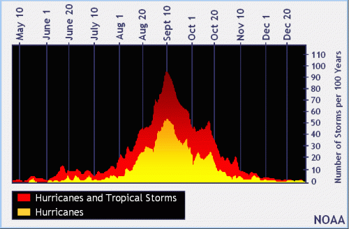
Hurricanes form in the hottest parts of the year.
Distribution of hurricanes by month during the last 100 years.
But the question concerned correlation, not causation.
Other outside factors could reduce precipitation, such as droughts triggered by changes in Pacific Ocean currents. Those who remember the drought from 2011 to 2014 may also remember how hot it was.
But looking at 80 to 130 years of data highlights long-term climate trends. That “evens out” the influence of individual events.
Qualifiers
NWS plotted all available historical data for precipitation and temperature on line graphs and then superimposed trend lines. The graphs show official data from two sources: Houston-Hobby Airport and the “City of Houston.”
I put City of Houston in quotes because the the official City-of-Houston data is currently collected at Bush Intercontinental Airport. But the location has bounced around. So the “City” isn’t one location, but many:
Cotton Station (July 1881 – September 1909)
Stewart Building at Preston and Fannin (September 1909 – February 1926)
Shell Building at Texas and Fannin (March 1926 – August 1938)
Federal Building at Franklin and Fannin (August 1938 – May 1969)
Intercontinental Airport (June 1969 – Present)
We have less data for Houston-Hobby because Hobby Airport didn’t exist until 1927. That’s when someone turned a 600-acre pasture into a landing field. The City of Houston purchased the field in 1937 and expanded it.
With those qualifiers, see the charts below. Both temperature and rainfall vary from year to year. But rainfall shows extreme variance. Regardless, in all four graphs the trend lines slowly increase.
Houston-Hobby Airport
Mean temps at Hobby increased from 69 to 73 degrees – a 4 degree increase between 1931 and 2022.During roughly the same time period, precipitation increased approximately 9 inches from about 48 to 57 inches.Also notice the extreme range – from less than 30 to more than 80 inches.
City of Houston Data
The City of Houston data covers a wider time period. Within that, the location varied as noted above. The big jump was from downtown to Bush Intercontinental Airport in 1969. Generally speaking, as you go farther north from the coast, precipitation decreases. But the difference is less than an inch. Atlas 14 shows that a 100-year, 24-hour storm is 17.6 inches at Hobby, 17 inches downtown, and 16.9 inches at Intercontinental.
City data indicates mean temp has increased roughly 4 degrees in last 120 years.During roughly the same years, precipitation increased about 5-6 inches. Here, the range was even more extreme. From less than 20 inches to 80 – a 4X difference.
So the change in where the City collects official data actually worked against the hypothesis. And it shows.
Summary of Trend Differences
Summarizing the key differences:
As the temp trend line increased 4 degrees at Hobby, precipitation increased 9 inches.
As temp increased 4 degrees at various City locations, precipitation increased 6 inches.
Low Coefficient of Correlation
Jimmy Fowler of the National Weather Service’s Houston/Galveston office calculated the coefficients of correlation between the two series of data at each location.
For Hobby, the coefficient of correlation is only .03. The City’s is slightly higher at .11.
Jimmy Fowler, Meteorologist, National Weather Service
For those who didn’t study statistics in college, the coefficient of correlation tells you how much one variable changes in response to another.
A perfect positive correlation is 1.0. Example: population growth and food consumption.
A perfect negative correlation is -1. Example: hours worked and free time.
In both cases, one unit of change in the first variable accounts for an equal unit of change in the second. But most correlations fall between the two extremes with different degrees of strength.
The chart below indicates how scientists would characterize correlation coefficients of .03 and .11. Both are considered “very weak” or having “no association.”
So, if the trends are all up, why is the co-efficient of correlation so low? Part of the answer has to do with those R2 (R squared) values you see at the bottom of the charts. They show the data doesn’t conform to the trend lines very well. Temperature fits moderately well. But precipitation shows extreme variance.
A perfect fit (1.0) would show all the data points on the line. As a rule of thumb, 0.8 (80%) or higher is considered a good fit. But the R2 values in these trend lines range from 0.03 to 0.5.
Conclusion
You can read into this data whatever you want depending on your point of view. Climate change advocates might see proof in the consistent slope of the trend lines that warming temperatures and more precipitation are related. A deeper dig into the data reveals the correlation is weak at best and possibly non-existent. Other factors may be at play and influencing the data.
To demonstrate causation, you need to show a directional relationship with no alternative explanations. But with weather, you have a multitude of alternative explanations.
Remember that weather is global and that we looked only at Houston in this instance.
However, a friend who traded weather-related derivatives before retirement tracked hundreds of temperature sites. He found they all trended warmer over time. But he believed the variance resulted primarily from changes in surrounding ground cover, i.e., replacement of natural ground cover with concrete – also known as the urban heat island effect.
He also tracked variance to changes in measurement locations (as with Houston).
Finally, remember that some of the hottest and coldest places on earth get very little precipitation. The Sahara and the North and South Poles are all considered deserts based of the amount of precipitation they get.
Net: I find the similarities in the graphs interesting enough to keep digging. As my friend suggested, it would be interesting to find the coefficient of correlation between population growth and temperature change. I won’t leap to any generalizations at this point.
Posted by Bob Rehak on 12/30/2022with thanks to Jeff Lindner, Harris County Meteorologist and Jimmy Fowler of the National Weather Service.
1949 Days since Hurricane Harvey
https://i0.wp.com/reduceflooding.com/wp-content/uploads/2022/12/Hobby-Rainfall.png?fit=3144%2C2282&ssl=122823144adminadmin2022-12-30 17:24:042022-12-31 12:50:38Is Precipitation Increasing with Temperature?
Creating a land bank for future flood-mitigation could reduce mitigation costs, speed up projects, and protect the lives and homes of millions.
When we should acquire land for future flood mitigation.When we usually try to acquire it.
Why Flood Mitigation Takes So Long and Costs so Much
Five and a half years after Harvey, officials are still struggling to finance many flood-mitigation projects. Part of the issue has to do with high land-acquisition costs for large, stormwater detention basins and for widening channels.
The San Jacinto River Basin Master Drainage study recommended 16 such projects in the upper basin. The plan includes 10 large regional detention facilities comprising approximately 229,000 ac-ft and six channel projects covering about 38.5 stream miles. Total cost: $2.9 to $3.3 billion (including construction). Land acquisition comprises a large percentage of that total. To put that in perspective, 229,000 acre feet is more than half the capacity of Lake Conroe. And 38.5 miles is exactly the distance from downtown Conroe to downtown Houston. And the cost totals more than Harris County’s 2018 flood bond.
Acquisition costs can vary greatly depending on whether the land is rural or urban; in a flood plain or not; wetlands or not; at a low or high elevation; distance to market; highway access; and other factors.
Ironically, the SJRA studied some of the same recommended detention basins along Spring Creek and its tributaries more than almost 40 years ago. A 1985 study on the Upper River Basin included a chapter on planning. It recommended…
“Right of way and reservoir land acquisition should occur while the land is open and available.”
Had people only listened, taxpayers might have saved a billion dollars or more. Land costs then were a small fraction of today’s. Only 1.8% of the watershed was developed. So why didn’t the interested parties start buying the land back then?
How Benefit/Cost Ratio Can Disincentivize Planning
Even though the costs were far lower, the benefits of buying farm or timber land were even lower still. Developments had to creep much closer before the Benefit/Cost Ratios increased enough to justify the expenditures. But of course, at that point people were already flooding or in danger of flooding. Now, repetitive payouts from the National Flood Insurance Plan help document the “benefits” of buying the land.
So why not create a land bank for future flood mitigation projects?
Buy the land when it’s cheap.
Put it “in the bank.”
Build detention basins on it when needed.
Land-Bank Precedents
There are precedents for this idea.
USDA started its Soil Bank in 1956. Basically, it pays farmers to take land out of production to support crop prices and farm income while preserving soil.
Land banks around the world acquire, hold, manage, and sometimes redevelop property for productive use and to meet community goals, such as increasing affordable housing or stabilizing property values.
Wetlands mitigation banks help preserve valuable wetlands to mitigate damage associated with new developments
HCFCD’s Frontier Program buys up land in rural areas, then develops flood mitigation projects on it. The District sells “detention capacity” to developers to help reduce its costs. This also ensures sufficient capacity for planned developments and optimum efficiency for flood-control projects.
In a similar vein, why not create land banks for flood-mitigation?
Forty years ago, when these projects were first studied, the benefit/cost ratio didn’t justify the purchase. Fast forward.
Benefits of Land Bank
Now, we’re looking at purchasing the same land, but because of inflation and development, the land cost is vastly higher. Had the land been purchased and “banked” way back then, the results would have been:
To be eligible for the proposed flood-mitigation land bank, the land would have to be:
Near a stream or river
Suited for building flood-mitigation projects (i.e., have the right topography)
In or around growing areas, such as Houston, where it would be needed for flood mitigation in a reasonable number of years.
If it contains forests or wetlands, it gets bonus points because its already reducing flooding.
In summary, the idea is to reduce future costs by purchasing land (at market rates) when it’s cheap. It has the added benefits of:
Preserving floodplains, wetlands and forests
Preventing flood damage
Shortening the time needed to develop mitigation projects
How Much Flood Damage Could Have Been Prevented?
The United States needs to re-engineer its flood-mitigation business processes. Flood mitigation takes costs too much and takes too long because we wait too long.
The San Jancinto River Master Drainage Plan released in 2020 points out significant flooding in 1940, 1960, 1973, 1994, 2016, 2017, and 2019 along with numerous other smaller flood events. We’ve been studying the problem for more than 40 years without actually mitigating it. A flood-mitigation land bank could help reduce costs speed up mitigation, and protect people before they flood.
It would be interesting to calculate how much damage could have been prevented in the last four of those floods had all the projects in the 1985 plan been implemented.
Posted by Bob Rehak on 12/28/2022
1947 Days since Hurricane Harvey
https://i0.wp.com/reduceflooding.com/wp-content/uploads/2022/12/20220722-RJR_0571.jpg?fit=1200%2C800&ssl=18001200adminadmin2022-12-28 19:56:232022-12-28 20:06:46Create Land Bank for Future Flood-Mitigation Projects
In a devastating ruling for Quadvest, L.P., and Woodland Oaks Utility, L.P., John Delaney, visiting judge in the 284th District Court in Montgomery County, rejected their pre-trial arguments and granted a summary judgment that validated the San Jacinto River Authority’s Groundwater Reduction Plan (GRP) contract. Both Quadvest and Woodland Oaks have been subsidence deniers in the past.
The key to reducing subsidence in Montgomery County. SJRA water treatment plant at Lake Conroe Dam. Image courtesy of SJRA.
The only question now is whether the SJRA’s water rates are fair. However, Jace Houston, SJRA general manager, points out that SJRA makes no profit from selling water and that the defendants have cost the river authority more than $12.7 million by withholding contractual payments due under the GRP contract.
Other signers of the contract who did not contest it have had to pick up the slack for Quadvest and Woodland Oaks, placing an unfair burden on them. Both companies are private companies that pump groundwater in Montgomery County.
In a separate order on the same day, Judge Delaney ruled on the defendant’s defenses. Quadvest and Woodland Oaks claimed:
Lack of consideration
Failure of consideration
Fraud
Illegality
Mutual Mistake
In the second order, the Judge simply stated that those defenses were DENIED.
The order concluded, “The Court has determined as a matter of law that “SJRA’s GRP Contracts are incontestable, valid, and enforceable according to their terms.”
Why Contract is Incontestable
State law makes it clear that when a contract is signed that relates to a bond offering and which has been approved by the State Attorney General, the contract is incontestable. In this case, the SJRA issued $550 million of bonds and the Texas Attorney General approved the contract.
SJRA used the bonds to build its surface water treatment plant on Lake Conroe and a distribution system. The distribution system also required acquiring rights of way.
“Consideration” received by the 80 entities signing the contract included:
Reduced costs because they didn’t have to re-dig wells as often when aquifers depleted.
Quadvest and Woodland Oaks claimed they received no consideration because LSGCD had since changed its rules after the current Board became elected in 2018 – thanks in large part to major contributions by Quadvest.
The goal of reducing groundwater usage was an attempt by suppliers in the region to reduce subsidence.
Since 2020, Quadvest and Woodlands Oaks have refused to pay the rate due under the contract, but have continued to charge their customers as if they are abiding by the contracted amount.
Jace Houston, SJRA general manager, points out that the defendants had 30 other groundwater reduction plans they could have joined back in 2010 (when the contract went into effect) if they felt they weren’t getting fair consideration.
Subsidence reduced, then leveled off for several years after the contract. However, it is now accelerating again thanks to virtually unlimited groundwater pumping by Quadvest and others.
Second Lawsuit Still Winding its Way Through Courts
Although the ruling applied only to Quadvest and Woodland Oaks, it also has implications for two other entities, the Cities of Magnolia and Conroe.
Both signed the SJRA GRP contract. And both withhold payments. Magnolia is currently $800,000 in arrears and Conroe owes $15.8 million. With Quadvest and Woodland Oaks, that brings the total owed to the SJRA up to $29.3 million.
However, Magnolia and Conroe are not making the same claims as the two private entities. They claim “governmental immunity.”
Interestingly, the attorney general is worried about such claims BETWEEN governmental entities. If for some reason a judge allows the claim, a high percentage of regional water supply contracts in the State of Texas could become unenforceable, according to Mr. Houston. As a result, the Texas Water Development Board has stopped making loans and grants to entities in breach of such contracts. Interestingly, of the 80 parties signing the SJRA GRP contract, virtually half are governmental entities of some sort.
Next Steps
“Quadvest and others have tried for years to cloud the issues and confuse the public about the GRP Contracts, and today all of that has been put to rest,” said Mr. Houston. “Decisions up to this point have been on pre-trial matters such as jurisdiction and venue. We are pleased to have a ruling on the merits that declares the GRP contracts valid and incontestable in any court.”
“Any further proceedings in Montgomery County should only be to verify that the rates are reasonable,” said Houston. “We look forward to presenting to the court how SJRA takes great care to prepare a very conservative and reasonable budget, and charge rates that are ultimately voted on by our customers.”
Judge Delaney’s rulings, though not directly on the subject of subsidence, have the potential to impact it. Without a financial incentive by companies like Quadvest to deny subsidence, perhaps the LSGCD board will quit trying to deny it, too.
Posted by Bob Rehak on 12/21/2022
1940 Days since Hurricane Harvey
The thoughts expressed in this post represent opinions on matters of public concern and safety. They are protected by the First Amendment of the US Constitution and the Anti-SLAPP Statute of the Great State of Texas.
https://i0.wp.com/reduceflooding.com/wp-content/uploads/2022/12/20100405-2016_09_30_AERIAL_SJRA-WTP_26.jpg?fit=1200%2C818&ssl=18181200adminadmin2022-12-21 15:46:332022-12-27 17:57:51MoCo District Judge Slams Door on Subsidence Deniers
Early in the morning on December 16, 2022, NASA launched a new satellite that will map and subsequently measure changes in virtually all of the Earth’s rivers, lakes and oceans. High-resolution imaging will even be able to measure changes in ocean currents and temperatures. Scientists will use the imaging capabilities to better understand flooding, droughts and coastal erosion. One said it will “revolutionize hydrology.”
About the Satellite and Orbit
The satellite will orbit more than 550 miles high. Nicknamed SWOT (Surface Water and Ocean Topography), the mission will cover the globe between the Arctic and Antarctica at least once every three weeks.
About the size of a SUV, the satellite will measure the height of water on more than 90% of Earth’s surface. It will enable scientists to track water flow and identify potential high-risk areas.
SWOT’s dual antennas at work. Image Credit: NASA.
The heart of the improvements is an innovative instrument called the Ka-band radar interferometer (KaRIn) – a major technological advance. KaRIn bounces radar pulses off the water’s surface and receives the return signal using two antennas on either side of the spacecraft.
According to NASA, for the first six months after launch, SWOT will be in a “fast-sampling” phase with a 1-day repeat orbit. Objectives in this phase include calibration and validation while studying rapidly changing phenomena.
The next phase – Operations & Sustainment – should last about three years It will have a 21-day repeat orbit to balance global coverage and sampling. NASA chose this “non-sun-synchronous orbit to minimize tidal aliasing and ensure coverage of major water bodies on land.” SWOT’s 75-mi-wide swath will result in overlapping measurements over most of the globe with an average revisit time of 11 days.
For a discussion of “tidal aliasing,” see this article in Geophysical Journal International. It’s about overcoming errors in current models that have to do with undersampling, uncertainty, imperfections and low-resolution.
Scientists Describe Anticipated Benefits
Scientists working on the mission described anticipated benefits:
Larry Smith: “Through acquisition of high-resolution, spatially continuous measurements of inland water surface elevations, SWOT stands poised to revolutionize terrestrial hydrology in much the same way that Seasat transformed physical oceanography in 1978.”
Mike Durand: SWOT will help us “better understand how precipitation is partitioned (runoff, evapotranspiration, storage).”
Colin Gleason: “SWOT’s downstream estimates of river discharge will form perhaps the world’s most complete accounting of human alteration of river flow.”
Marc Simard: It will tell us “where surface water flows and where it is stored, everywhere on Earth.”
Doug Vandemark: “New data will aid existing weather prediction models in terms of how they resolve and predict heat and energy exchange between the atmosphere and oceans in both fair and foul weather situations.”
Demitris Menemenlis: SWOT will give us “increased predictive skill for weather forecasting.”
David Sandwell: It will “improve our mapping of the marine [environment] by perhaps a factor of 5.”
SWOT is a joint effort of NASA and the French space agency CNES, with contributions from the Canadian and United Kingdom space agencies.
Posted by Bob Rehak on 12/18/22
1937 Days since Hurricane Harvey
https://i0.wp.com/reduceflooding.com/wp-content/uploads/2022/12/Screenshot-2022-12-18-at-11.42.09-AM.png?fit=1414%2C826&ssl=18261414adminadmin2022-12-18 11:47:132022-12-18 11:54:03New NASA Satellite Will Measure Changes in Earth’s Rivers, Lakes, Oceans
This week, contractors completed the demotion of the old Kingwood Middle School (KMS). This clears the way for construction of the new, larger, permanent stormwater-detention basin and rebuilding of athletic fields in front of the new KMS. Even the foundation has been removed.
Photos Taken Dec. 17, 2022
Demolition of old school complete.Looking NW toward Woodland Hills.Looking East. Note temporary detention pond alone Pine Terrace on right.Looking N toward new schoolLooking west toward Woodland Hills at what will become the new athletic fields.
The old Kingwood Middle School was the first middle school in Kingwood and served Kingwood students for 45 years. Humble ISD built it in 1977.
With completion of the demolition of the old KMS, a piece of Kingwood history is gone. But a new chapter begins with a gorgeous new showcase that speaks for the resilience and quality of one of the finest communities in southeast Texas.
Progress of Construction in Photos
For photos showing the progress of KMS construction and demolition, see below.
I can’t wait to see this project when it is complete!
Posted by Bob Rehak on 12/17/22
1936 Days since Hurricane Harvey
https://i0.wp.com/reduceflooding.com/wp-content/uploads/2022/12/20221217-DJI_0507.jpg?fit=1200%2C799&ssl=17991200adminadmin2022-12-17 17:45:012022-12-17 17:45:06Demolition of old KMS Complete