Although much finish work remains, contractors have finished blocking out New Caney ISD’s new West Fork High School. Walls, structural steel and roofs are up. Some windows are in. Now they are widening Sorters-McClellan Road. They are also building another access route through woods that will connect to Kingwood Place Drive, the street immediately west of the HCA Kingwood Medical Center.
Photos Taken 11/6/2021
I took all of the shots below on November 6, 2021, with the exception of the last one from November a year ago.
New Caney ISD West Fork High School Construction as of 11/6/2021. Looking NE from over Sorters-McClellan Road toward HCA Kingwood Medical Center and Insperity in top center.Looking south from over Sorters-McClellan Road, which is apparently being widened in front of the high school and then some.Note the wetlands and cypress trees in the upper right.Looking north from over detention pond at south end of campus. I-69 in upper right.Fieldhouse, track and football field.New access road through woods will connect with Kingwood Place DriveLooking south. Note windows being installed in center.Looking SE. Much sitework remains.From a higher altitude, you can see the proximity to the San Jacinto West Fork. From the upper left, it curves around the large pond then becomes visible again to the left of the sand mine in the upper right.
Wetlands Gone Forever
From US Fish and Wildlife Service Wetlands Mapper. Green areas are/were freshwater forested/shrub wetlands. Blue/gray areas are freshwater ponds. High school site is in center of frame. Image taken shortly after clearing.Note large area of former wetlands where athletic fields will be.
I’m sorry to see the wetlands go, but now that they’re gone, I want to see them complete the drainage for this campus ASAP to make sure everything gets channeled into the detention pond. That will minimize the chance of flooding neighbors.
New Caney ISD expects to finish construction by the summer of 2022.
General plan for New Caney High School #3
Posted by Bob Rehak on November 8, 2021
1532 Days since Hurricane Harvey
https://i0.wp.com/reduceflooding.com/wp-content/uploads/2021/11/20211106-DJI_0723.jpg?fit=1200%2C799&ssl=17991200adminadmin2021-11-07 17:24:212021-11-07 21:25:37New Caney ISD’s West Fork High School Blocked Out; Access Being Enhanced
Imagine you’re getting on an airplane and you see someone popping rivets out of the wing. You ask the pilot, “What’s that guy doing!?”
The pilot says, “Oh, he’s popping rivets. Our accountants have found that can eliminate weight and improve fuel economy.”
“But won’t that increase risk?” you ask.
The pilot replies, “Somewhat, but our engineers believe it won’t bring the plane down.”
Would you get on that airplane? Would you live in this proposed development? Or downstream from it? See details below.
Details of Northpark South
Here are the plans presented to the Planning Commission last Thursday for a plat of Northpark South. The commission deferred action on them until the next meeting. The developer is Hannover Estates, LTD. RG Miller engineered the development.
Pretty location!Just don’t let your kids go fishing there.
Of course, the homes will be built on the highest ground. But look how far the floodplain (dotted line) cuts into them.
Northpark South floodplains. Of course, these are based on 1980s data. Don’t be fooled by the data on the map. That’s the date of the background image. In Harris County, the new flood maps will reportedly expand the floodplains by 50% as a rule of thumb. But this is MoCoand the last update was much longer ago.
Here’s how that area looked during Harvey.
US Fish & Wildlife Service Map of wetlands (and former wetlands) on the site (center of frame).
Looking W from over end of Northpark Drive. Sorters-McClellan cuts through bottom of frame from left to right. West Fork cuts through sand mines in the background.
The barren spot just right of center is the wetland area that will be filled in to make home sites.
Meet the neighbors.
Where the subdivision drainage will go…straight into the West Fork.
Water flowed so quickly through this area during Harvey that it moved and sunk this excavator within the mine.
Another Development Targeted at the Uninitiated?
The shame of it is that if Northpark South gets built, the developer will likely build starter homes and market them to couples with young children. They’re the least knowledgeable about flood risk.
Posted by Bob Rehak on 10/31/2021with thanks to Paul Ehrlich for the parable and Mai Truong for the heads up on this
1524 Days since Hurricane Harvey
The thoughts expressed in this post represent opinions on matters of public concern and safety. They are protected by the First Amendment of the US Constitution and the Anti-SLAPP Statute of the Great State of Texas.
https://i0.wp.com/reduceflooding.com/wp-content/uploads/2021/10/20211031-DJI_0631.jpg?fit=1200%2C800&ssl=18001200adminadmin2021-10-31 19:31:372021-11-01 17:50:50More West Fork Wetlands near Northpark Drive Could Soon Be Developed
Wetlands are nature’s way of slowing water down after a rain. They also filter runoff before it reaches streams, reducing the amount of sediment pollution.
Looking north from a helicopter. Notice how ditch and roads are beginning to push into woods at top of frame.As with previous sections recently developed, Colony Ridge is not too picky about piling dirt next to ditches where sediment can wash back in.Piling dirt next to the ditches seems to be a standard practice.Note how it’s already washing back into the ditch in the lower left of this photo.
If the developer were following best management practices, according to the TCEQ and Stormwater Pollution Protection Plan recommendations, you would expect to see temporary grass, rock gabions, silt fences, and hay bales in these photos. All check the flow of sediment into ditches.
Draining the swampLooking SE toward the east part of Sante Fe (Sections 6-11) already cleared. Note swampy areas at bottom left.
Biden Trying to Restore Clean Water Act Protections
Ironically, all this development comes as the EPA under the Biden administration seeks to put teeth back into the Clean Water Act. The administration is trying to restore the definition of “Waters of the United States” that Trump restricted. Yesterday, the Justice Department submitted a legal filing that begins that process.
The EPA and Department of the Army have formally requested repeal of the Trump-era rule. That rule exempted many developments near upstream tributaries such as Luce and Tarkington Bayous from the need to obtain permits under the Clean Water Act. It basically removed large swaths of land from regulation by the US Army Corps of Engineers.
According to this Associated Press article by Matthew Daly on 6/9/2021, environmental groups and public health advocates said Trump’s interpretation of Waters of the US “allowed businesses to dump pollutants into unprotected waterways and fill in some wetlands, threatening public water supplies downstream and harming wildlife and habitat.”
Daly quotes Jaime Pinkham, acting assistant Army secretary for civil works as saying, “The Trump-era rule resulted in a 25% reduction in the number of streams and wetlands that are afforded federal protection.”
It’s unclear at this time whether rollback of Trump regulations will affect Colony Ridge. Even if the changes survive legal and legislative challenges, it could be years before they take affect.
The thoughts expressed in this post represent opinions on matters of public concern and safety. They are protected by the First Amendment of the US Constitution and the Anti-SLAPP Statute of the Great State of Texas.
https://i0.wp.com/reduceflooding.com/wp-content/uploads/2021/06/RJR_8410.jpg?fit=1200%2C800&ssl=18001200adminadmin2021-06-10 17:39:512021-06-10 17:56:09Colony Ridge Expanding North Into More Wetlands
A study by Samuel D. Brody, Sammy Zahran, Wesley E. Highfield, Himanshu Grover, and Arnold Vedlitz called “Identifying the impact of the built environment on flood damage in Texas” quantifies the flood reduction benefits of wetlands along the Gulf coast. The authors studied property damage in 423 floods between 1997 and 2001. They identified the effect of several built-environment issues, including wetland alteration, impervious surface and dams on reported property damage while controlling for biophysical and socio-economic characteristics.
Their statistical results suggest that naturally occurring wetlands play a particularly important role in mitigating flood damage. But how much? The results vary by location, of course, but in one county, they discovered that a 3.4X increase in wetland alteration permits correlated to a 10X increase in flood damage.
Floods damage more property than any other type of natural disaster in America – billions of dollars every year. However, the author’s say, there is lack of research on the relationship between the built environment and flood impacts in the eastern portion of Texas. Say the authors, “Such information is critical given the continued development of coastal areas and the increasing vulnerability of human populations to inland coastal flooding.”
What Study Correlated and How
The authors correlated flood property damage (total dollar loss adjusted by the consumer price index) to variables such as:
Precipitation (day of flood)
Precipitation (day before flood)
Percentage of county in 100-year floodplains
Duration of flood
Dams
Percent impervious surface
Wetland alteration
FEMA Community Rating System
Median Household Income
They measured everything by counties. Watershed data would have been better for floods, but damage is not often aggregated by watersheds.
Researchers measured “wetland alterations” by counting wetland permits issued by the US Army Corps of Engineers in Galveston under Section 404 of the Clean Water Act. They simply counted the number of permits issued up to the day of any given flood. This enabled them to measure the cumulative impact of wetland alterations over time.
FEMA’s Community Rating System encourages city and county leaders to promote responsible development over time. The more an area reduces flood damage through regulations, mapping and 18 flood mitigation measures, the higher the discounts that residents earn on flood insurance.
The researchers used multivariate regression analyses to find which factors most influenced the degree of flood damage in eastern Texas. Multivariate regression identifies the degree of influence that multiple variables have over each other. It measures correlation, not causation.
Major Findings
Specific characteristics of the human-built environment in eastern Texas have an important influence on property damage resulting from floods, even when controlling for biophysical and socio-economic factors. Below are four major findings from the study.
First. the amount and duration of precipitation associated with a given storm flood largely governs flood damage.
When looking at biophysical variables, timing of precipitation is particularly important. “Heavy precipitation the day before the actual flood event is by far the strongest predictor of total property damage,” say the authors. This may be because of the delay in the rise of water or the saturation of soil. “It is important for decision-makers and the public to understand that heavy precipitation followed by sunny skies can still result in significant flood damage the next day.”
Second, the most important built-environment indicator of flood damage is the the alteration of naturally occurring wetlands.
“Impervious surfaces have long been criticised for their contribution to increased flooding and associated damage. However, the most significant impact may not depend solely on the total amount of imperviousness in a watershed or drainage basin, but rather on where exactly these built surfaces are placed. Altering or removing a wetland to construct car parks, roads and rooftops, for instance, effectively eliminates its ability to capture, hold and store water run-off.”
For example, comparing two identical rainfalls four years apart in De Witt County showed a 10X increase in damage. During that time, the number of wetland permits granted increased from 5 to 17 – 3.4X.
Similarly, comparing two 1.5 inch rainfalls in Wharton County, damage doubled while the number of wetland-alteration permits increased from 17 to 26.
Incredibly, Galveston County experienced a 20X increase in flood damage based on two 0.09 inch rainfalls three years apart. During that time, the number of wetland permits increased from 546 to 921.
“Developments initially believed to be safe from flood threats become an unexpected target of expensive flood damage over time,” say the authors. “The planning goal in this situation is to allow development to proceed without reducing the hydrological function and value of wetland systems.”
The authors suggest that achieving this objective will involve identifying and protecting wetlands through local land use policies. They include zoning restrictions, land acquisition programs, clustered development, density bonuses and more. Net economic benefits to a locality may result by reducing costs related to repair of damaged structures and mitigation solutions.
Third, wetlands may be more effective than dams in mitigating property loss over time.
Dams are extremely costly mitigation alternatives. And they can encourage development in flood-prone areas out of a false sense of security. See more below.
Fourth, FEMA’s Community Rating System reduces property damage.
Communities ranked high by FEMA for mitigation measures experience significantly lower amounts of flood-related property damage. “In fact, CRS participation appears to reduce community-wide flood damage more than dams, which are far more costly,” the study claims.
Economic Tradeoffs
In comparing the relative effects of various variables on flood damage, the authors also assessed economic tradeoffs of various mitigation measures.
For instance, they compared the cost in property damage in a flood to the price of wetland permits and dams. They found that 129 wetland alteration permits cost as much property damage per flood as one dam saved.
“Given the expense of building dams, their negative environmental ramifications, and the possibility of structural failure, protecting naturally occurring wetlands may be a more rational policy alternative,” says the study.
Posted by Bob Rehak on 1/30/21 based on a study by Samuel Brody, et. al.
1250 Days since Hurricane Harvey
https://i0.wp.com/reduceflooding.com/wp-content/uploads/2018/11/SJR_704_048-e1612057029212.jpg?fit=1200%2C811&ssl=18111200adminadmin2021-01-30 19:57:462021-02-01 15:54:48Scientists Quantify Flood-Damage-Reduction Benefit of Texas Wetlands
The National Weather Service distinguishes between four major types of flooding: coastal, riverine, street and sheet flow. After flying over Colony Ridge on New Year’s Day, I would add a fifth: flooding by government neglect.
Despite dire predictions for the New Year’s Eve storm, the Plum Grove/Colony Ridge area in Liberty County only got about two inches of rain. Yet I saw hundreds of flooded lots. They were all in a development that:
Worst of all, when residents asked for help from their elected Liberty County officials, those officials berated and rebuffed them. They refused even to acknowledge problems in Colony Ridge.
Where It Starts
Irregularities that most banks would catch as part of a title search and survey during the mortgage application process never get caught here.
That’s because the developer targets a vulnerable population more likely to use Western Union money orders than banks. He offers them owner financing with low down payments and interest rates five times higher than the market.
These un-savvy buyers are so desperate to own a piece of the American dream that they wind up mired in one nightmare after another. Many speak English as a second language if they speak it at all.
A Two-Inch Rain
Trade those SVUs in for swamp buggies. Here’s what much of the development looked like 24 hours after two inches of rain fell on New Year’s Eve.
Note how the drainage stops in the middle foreground.Also note how it’s not infiltrating like the engineers said it would.Close up of home in first shot. At least the home didn’t flood although the four-wheelerand dining area did.Even if an owner builds up one part of his/her lot, it can flood another.Lot after lot flooded. Water would not sink in. The soils have a low rate of infiltration, not the high rate promised by LandPlan Engineering.Totally flooded lot. Note how drainage stops to left of driveway.Do-it-yourself repairs.But are they up to code?Former wetlands?
Targeting the Vulnerable
Most of these people never complain. The areas in Mexico and Central America where many came from may have conditions far worse. So what you see here may be an improvement for them.
Still, one can’t wonder whether – in its zeal to grow – Liberty County has turned a blind eye to conditions that violate its own regulations as well as human dignity.
Conditions such as these will take generations to improve. In the meantime, the County’s residents are in for decades of pain due to government neglect. Not just in Colony Ridge, but in neighboring communities such as Plum Grove and others farther downstream.
This developer has permanently altered the hydrology of the watershed in a way that increases flood risk for everyone.
And the county has lowered its standards in a way that will likely discourage investment from quality developers.
Posted by Bob Rehak on 1/3/2021
1223 Days after Hurricane Harvey and 472 after Imelda
The thoughts expressed in this post represent opinions on matters of public concern and safety. They are protected by the First Amendment of the US Constitution and the Anti-SLAPP Statute of the Great State of Texas.
https://i0.wp.com/reduceflooding.com/wp-content/uploads/2021/01/20210101-RJR_4809.jpg?fit=1200%2C800&ssl=18001200adminadmin2021-01-02 20:55:332021-01-03 16:57:55Flooding of the Fifth Kind: By Government Neglect
One of the most beautiful parts of Kingwood also helps protect the area from flooding: East End Park. If you’ve never seen it, you should. The park comprises 158 acres and contains about five miles of nature trails. With the help of boardwalks, the trails wind through wetlands that form the perimeter of the park.
Those wetlands help slow runoff during storms. And the park itself puts distance and elevation between the East Fork of the San Jacinto and the nearest homes.
Park Almost Became Another Subdivision During 1980s
The park was not always destined to become a park. Originally Friendswood Development wanted to build another subdivision where the park is now. As Friendswood cut streets in nearby Kings Point, they dumped the extra dirt in what is now the park’s giant meadow. That’s why it’s so much higher than surrounding wetlands.
These meadows comprise approximately 45 acres of tall grass, an abundant food source for migrating birds.Looking south. The East Fork San Jacinto is on the left. Sand damage from Harvey and Imelda at Eagle Point is in the foreground.Birdhouses once 10-feet up on trees are now at ankle height.Looking west from the north side of the park on the left. The East Fork (out of frame to the right) and Caney Creek converge at East End Park’s Eagle Point.Also to the right is the 5000-acre Lake Houston Nature Park.Looking south again. The East Fork on the left empties into Lake Houston in background. Trails border the river within the trees.
But in 1988, the EPA issued a cease and desist order because they were jeopardizing the wetlands. Blocked from further development, Friendswood tried to turn a problem into an amenity that could add value to homebuyers. The company donated the land to the Kingwood Service Association to own and operate as a park for the benefit of all Kingwood residents.
Development as Nature Park in 2000s
Not much happened with the park for about a decade. Then KSA, with the help of volunteer groups, like the Boy Scouts, started building a small trail network, mostly on the north side of the park.
Around 2000, KSA debated the future of the remainder of the park. Should they turn it into more sports fields? Or keep it a nature park? The nature park faction won out. And for the next fifteen years, KSA slowly built new trails and improved old ones as money became available.
Birder’s Wonderland
The Lake Houston Nature Club has documented approximately 150 species of birds in the park, some threatened or endangered. In season, birders seem everywhere. Migrating birds munch on the abundant tall grass which seems to go to seed just in time for the migration.
In the park, I’ve spotted everything from painted buntings to majestic bald eagles. In fact, part of the park is named Eagle Point because of the frequent eagle sightings there.
Healing Power of Nature
Shortly after KSA put in the Eagle Point Trail, I encountered a man sitting in the same place on the river bank day after day. I asked him what his attraction was to that particular place. He said that it helped him heal. I asked if he wanted to explain that. He said he was undergoing treatment for cancer and the the beauty gave him the will to go on living. I suspect he’s not the only one who has found sustenance in nature there.
One often sees families walking with young children there. I also suspect kids learn to translate the love they feel from parents on such walks into a lifelong love of nature.
Living Lessons
Sadly both Harvey and Imelda completely inundated the park. Eagle Point became covered with 10-15 feet of sand which killed many of the trees there and filled in some of the wetlands. Regardless, the park remains a natural gem and a living lesson about the cycles of nature.
The pictures below show some of the natural beauty. To get to the park, take Kingwood Drive east until you run out of road. You can see the park entrance from the parking lot.
East End Park poster.
Sunrise over Lake Houston from Kingwood’s East End Park at Otter Point. By Dr. Charles Campbell.
Posted by Bob Rehak on 11/8/2020
1168 Days since Hurricane Harvey and 416 since Imelda
https://i0.wp.com/reduceflooding.com/wp-content/uploads/2020/11/20201023-DJI_0896-copy.jpg?fit=1200%2C900&ssl=19001200adminadmin2020-11-07 19:26:012020-11-08 10:40:39East End Park from the Air: A Wetlands Success Story
Often, I post about sand mines or developments that encroach on floodplains and floodways to the detriment of people downstream. But when I learned of this story, it made me extremely happy. The Bayou Land Conservancy (BLC) announced last week that Joe Swinbank and Don Poarch, partners at Sprint Sand & Clay, have donated 117 acres of unspoiled wetlands to the organization. The land borders Spring Creek in Tomball, north of Lone Star College and Harris County Precinct 4’s Spring Creek Park. It will have a significant impact on conservation, according to the BLC.
Natural wetlands on the tract donated to BLC by Swinbank and Poarch. This and all photos below are courtesy of the Bayou Land Conservancy.
“We are excited to own this ecologically rich nature preserve that will help us connect the community to the benefits of land conservation”, said BLC board chair Lisa Lin. “This donation will benefit the community for many generations, and be an enduring legacy of the incredible generosity of Mr. Swinbank and Mr. Poarch.”
Spring Creek meanders along the property’s southern border.
Ecologically rich wetlands such as these help retain water during floods, reducing the impact on downstream residents.
Land Originally Purchased for Mining
“As the greater Houston area continues to grow at a rapid pace, striking a healthy balance between land preservation and land development has never been more important as we seek to protect the many economic and community benefits we all enjoy,” Swinbank said. “The Bayou Land Conservancy’s extensive network of preserved trails and waterways just minutes from Houston is impressive in its form and function—a model of what can be achieved when community stakeholders work together. We’re proud to partner with the Conservancy to continue these important environmental efforts and extend BLC’s preserved trails and waterways west into the Tomball area.”
Don Poarch echoed his partner’s sentiments in acknowledging the award. “We’re grateful for the recognition as this year’s Conservation Champions and happy to continue to champion the BLC and its important mission to preserve these lands for natural flood control, cleaner water and wildlife protection,” Poarch said. “On behalf of our entire team at Sprint Sand & Clay, Joe and I hope this land along Spring Creek enhances the community with protected green space while providing beautiful trails and waterways for people to reconnect with nature and each other.”
Family History Led to Donation
Beyond the positive environmental and community impact, the land in Tomball has personal significance to Swinbank and his family. “My wife was raised in the area, and her extended family has deep roots in Tomball and Rosehill going back to the area’s original German settlers,” Swinbank added. “My family and I couldn’t be happier that the Conservancy will ensure this land is preserved and protected for generations to come.”
Location of new preserve
Online Gala to Honor Conservationists Nov. 13
BLC will honor Swinbank and Poarch at its annual Annual Land Lover Gala as Conservation Champions. The Gala will be held virtually this year from 6-7 pm on Friday, November 13th. More information about the event can be found here. Wildlife film maker Ben Masters will be the keynote speaker. Mark your calendar.
No-Cost Gala Great Way to Learn More About BLC
Because of COVID, BLC’s net proceeds will likely be down this year. There’s no cost to attend the virtual event. “We’d just like to encourage people to join us,” said Jill Boullion, Executive Director of the BLC.
On a personal note, I will say this. The Bayou Land Conservancy and its committed staff stand tall among many worthy conservation groups in the Lake Houston Area. Their cooperative strategy is simple.
They put conservation easements on environmentally important land that is bought or donated so that it serves its natural function. They make a huge difference and deserve everyone’s support.
Bayou Land Conservancy protects land along streams for flood control, clean water, and wildlife. BLC is a nationally accredited, community-sponsored land preservation organization working to permanently protect land, with a focus on the streams that feed Lake Houston, an important source of drinking water for millions in the region. More information is available at: www.bayouland.org.
Posted by Bob Rehak on 10/31/2020
1159 Days since Hurricane Harvey
https://i0.wp.com/reduceflooding.com/wp-content/uploads/2020/10/20190627-Poarch-Swinbank-22-2019-6-27.jpg?fit=1200%2C900&ssl=19001200adminadmin2020-10-31 14:30:112020-10-31 20:53:56Sand Miners Donate 117 Acres of Unspoiled Wetlands Along Spring Creek to Bayou Land Conservancy
In three years of writing about flooding, this is one of the most dramatic case studies I have seen about the value of wetlands. It starts with a developer clearing wetlands and ends with the developer at war with a neighboring town.
Wetlands as Protectors
Michael Shrader lived in a modest home in Plum Grove in Liberty County. It was an idyllic, rural lifestyle in many ways. He did tech work remotely while raising animals on his small plot of land near the East Fork of the San Jacinto and Maple Branch. Shrader never flooded for the first 29 years he lived in Plum Grove despite living on a creek. Not in 1994. Not in Allison. Not in Rita. And not in Ike.
Forests filled with wetlands surrounded him. Water ponded during heavy rains. Much of it soaked in and was absorbed by tree roots. The creeks ran clear.
Before Colony Ridge
In this 2008 Google Earth image, you can see the vibrant greens. And if you look closely enough on a desktop display, you can even see the ponds and wetlands east of FM1010.
Note area east (right) of FM1010.
For those reading on smaller displays, here’s the same image, but with data from the US Fish and Wildlife Service National Wetlands Inventory superimposed.
The bright, solid greens represent wetlands in the national inventory. Superimposition courtesy of Michael Shrader.
Then Came the Bulldozers
In 2016, the developer of Colony Ridge started clearing land and replacing wetlands with ditches that fed into Maple Branch. It runs right behind Shrader’s home. As the developer filled in more and more of the wetlands, water started getting higher in the creek after every rain, according to Shrader. Harvey, May 7th, Imelda: those were the high-water marks. And the low points in Shrader’s life. He flooded all three times.
By last year, the developer had replaced virtually all the wetlands by this.
By 2/23/19, most of the wetlands had been turned into streets with ditches in the world’s largest trailer park. Shrader lives on a stream that cuts across the NW portion of the grid.
Since the satellite image above was taken, even more forests and wetlands farther east and north have been replaced by what is now the world’s largest trailer park.
Eastern area in June, 2020.
Slash and burn development practices at Colony Ridge. Photo June 2020.Note how contractors are draining wetland area on left.
Lives Disrupted
With the wetlands gone, Shrader’s house flooded in 2017 during Harvey (admittedly an extreme event), and twice in 2019. Not only did his house flood, so did most of Plum Grove, including the City Hall. Now, Shrader says, many homes are vacant.
The fence below, immediately downstream from the Camino Real Subdivision in Colony Ridge, was pushed over three times by the increased flow of floodwaters coming down Maple Branch. The owners of the red-roofed house bought this property just before the first of three floods.
Flooded Plum Grove home near Maple Branch and Colony Ridge. Owners stopped repairing the fence after the second flood.
At least one investigative journalist is exploring alleged predatory lending practices.
Allegations of corruption in Liberty County politics abound.
Commissioner’s Court and City Council meetings have degenerated into heated shouting matches.
Soon, Hollywood screenwriters will develop screenplays based on the Plum Grove experience and pitch them as “the next Erin Brokovich.”
Eroded drainage ditch in Colony Ridge that blew out FM1010 at far end. Three years after Harvey, the road still had not been repaired, much to the dismay of residents.
FM1010, one of the main roads into and out of the development, destroyed by out-of-control stormwater.The loss of this road has led to massive traffic jams on alternate access routes, such as FM2090.
Sadly, a little more respect for Mother Nature could have easily prevented all that trouble for the developer. One wonders whether the engineers and environmental consultants whom he hired to obtain permits served him well.
Posted by Bob Rehak on 10/22/2020
1050 Days after Hurricane Harvey and 398 since Imelda
The thoughts expressed in this post represent opinions on matters of public concern and safety. They are protected by the First Amendment of the US Constitution and the Anti-SLAPP Statute of the Great State of Texas.
https://i0.wp.com/reduceflooding.com/wp-content/uploads/2020/10/20200616-RJR_3713.jpg?fit=1200%2C800&ssl=18001200adminadmin2020-10-22 01:54:072020-10-22 09:38:22How Loss of Wetlands Led to War
The City of Plum Grove on the San Jacinto East Fork has sued the developer of Colony Ridge over alleged breaches of an agreement that governs development in the City’s extra territorial jurisdiction. Colony Ridge is the world’s largest trailer park. Specifically, the City claims that Colony Ridge:
Allowed stormwater runoff from the development to flood the City
Failed to contain sewage that overflowed into neighborhoods and waterways
Parallels with Elm Grove Lawsuit against Woodridge Village Developer
This lawsuit has many parallels with a lawsuit by Elm Grove Village homeowners in Kingwood. They are suing Perry Homes, its subsidiaries and contractors for flooding hundreds of homes last year. Similarities include:
Neighboring homeowners vs. a developer that…
Clearcut land
Filled in wetlands
Without allegedly installing adequate detention or drainage
More than $1 Million in Damage to City Hall, Roads and Other Property
Plum Grove seeks damages for Colony Ridge’s “repeated and serious damage to City-owned or maintained buildings, roadways and other property.” The City claims more than $1 million in damages to date. But the City is not seeking compensation for damages. It wants the developer to fix the problems that are causing repeated flooding and sewage spills.
Causes of Action
Lawyers for Plum Grove cite several “causes of action” to support their claims and damages:
Breach of Contract
Negligence
Private Nuisance
Violation of Texas Water Code § 11.086
Trespass
Breach
“The fundamental breach of the Agreement arises from the fact that Defendant has paved over wetland area and/or diverted the flow of surface water without construction of adequate drainage or detention facilities. Because of developments by Defendant without conforming to applicable drainage standards and regulations, Plum Grove and the surrounding area are now experiencing significant flooding after major rainfall events,” says the lawsuit on pages 6 and 7.
From Liberty County Stormwater Regulations. Plum Grove’s agreement with the developer specified that the developer had to comply with these regulations.
Negligence
A defendant’s actions rise to the level of negligence under Texas law if 1) the defendant “owed a duty” to plaintiffs (had an obligation); 2) the defendant breached that duty; and 3) the breach caused the plaintiff’s damages.
Nuisance
Private nuisance is a condition that substantially interferes with the use and enjoyment of land by causing unreasonable discomfort or annoyance. In that regard, the suit mentions both flooding and the repeated overflow of sewage into creeks, ditches and property.
Water Code Violation
The Texas Water Code, Chapter 11.086, prohibits a person from diverting the natural flow of surface water in a manner that damages the property of another.
“Because of the increased stormwater runoff from Defendant’s developments during significant rain events like Hurricane Harvey, Tropical Storm Imelda, and the May 7, 2019 storm,” says the suit, “City Hall was flooded, City-owned/maintained roads, and residential areas have been inundated and City-owned/maintained bridges and culverts have experienced significant damage. Defendant’s actions constitute the wrongful diversion of surface water onto City property.”
Plum Grove residents allege that Colony Ridge cleared forests, filled in wetlands and re-routed runoff without adequate detention. And as a result, flood risk has increased within tiny Plum Grove which has only several hundred residents left. Many have been driven off already.
Trespass
The most interesting legal theory is that the stormwater “trespassed” on neighbor’s property. A defendant commits “trespass to real property,” claims the suit, “where there is an unauthorized entry upon the land of another, and may occur when one enters—or causes something to enter—another’s property.”
Problems Became Apparent in 2015
Further, the suit alleges that Colony ridge was aware of drainage violations since at least 2015 (Page 7). Finally, it alleges that had Colony Ridge followed County regulations and standards as required by the agreement with Plum Grove, that flooding and its impact on the City and nearby properties would have been significantly reduced.
Long-Time Resident Verifies City Claims
Resident Michael Shrader says that his property never flooded before Colony Ridge started clearing land upstream from his home on Maple Branch. He has lived in Plum Grove since 1987 and weathered huge storms in 1994 and 2001 (Tropical Storm Allison) without flooding. “The extreme flooding in my yard and home during more recent storms,” said Shrader, “was clearly a result of the Camino Real Colonia’s stormwater run-off that’s all directed to the head of Maple Branch that then runs behind my back yard. Colony Ridge is the only major change to the landscape since I’ve lived here. All the wetlands that were there are now gone!”
Area the way it existed in 2011, before Colony Ridge
Same area in 2019. Colony Ridge is still expanding today.See area at right.
Shrader’s house as water was still rising during Harvey. Shrader says it eventually got up to the windows in the foreground.
Maria Acevedo, another local land owner and activist has seen firsthand the construction practices at Colony Ridge. “Their lack of Best Management Practices has sent silt downstream. That silt as clogged drains and ditches, causing water to back up and overflow. The TCEQ has documented these practices. The longer such abuses continue, the more pushback this developer will get from Plum Grove residents and also residents of Colony Ridge.”
“We are not going away until they comply with the law.”
Maria Acevedo
More on that TCEQ report tomorrow. It’s 184 pages long and deserves its own post.
Posted by Bob Rehak on 10/15/2020
1143 Days since Hurricane Harvey and 392 since Imelda
The thoughts expressed in this post represent opinions on matters of public concern and safety. They are protected by the First Amendment of the US Constitution and the Anti-SLAPP Statute of the Great State of Texas.
https://i0.wp.com/reduceflooding.com/wp-content/uploads/2020/10/Front-Yard-Aug-27-2017.jpg?fit=1336%2C752&ssl=17521336adminadmin2020-10-15 18:17:332020-10-15 18:53:49Plum Grove Sues Colony Ridge Developer Over Floodwater, Sewage Leaks
Rapid runoff from Colony Ridge, perhaps the world’s largest trailer park, in Liberty County contributed to a washout of FM1010. Nearby residents in Plum Grove say it also contributed to the flooding of their homes. Moreover, erosion from the development has contributed to the buildup of sedimentation in the East Fork.
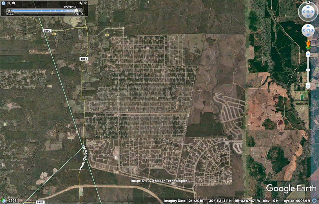
Nine years ago, this area was mostly forested wetlands. Today, it’s mostly mobil homes, many on barren lots, stretching mile after mile.
World’s Largest Trailer Park?
There is no definitive source ranking the size of trailer parks, but multiple references to Sun Valley in Nevada come up when you Google “world’s largest trailer park.” That development is one third the size of this one!
Nine years ago, Colony Ridge didn’t exist.
Satellite image from 2011.The land that would become Colony Ridge was covered with forests, wetlands and rice fields.Paper companies owned most of this land for decades and periodically harvested timber.Colony Ridge today. This is just the southern section. Two more sections are out of frame on the north.
By the end of 2019, Colony Ridge had grown to cover approximately 10,000 acres and it’s still expanding. It has transformed the landscape massively, and it’s not clear whether the development has provided sufficient detention to keep runoff at its predevelopment rate. Judging by the frequency of flood damage to surrounding homes and roads since Colony Ridge was developed, many local residents believe the answer is no.
Documentation about the design and effectiveness of the drainage systems is hard to come by. Authorities in Liberty County have not returned emails or phone calls. And the information is not posted online.
Entire Population Growth of Liberty County in Last Decade
Colony Ridge alone can account for all of the population growth in Liberty County in the last decade. The U.S. Census Bureau officially estimates that Liberty County’s population grew from 75,000 to 88,000 between 2010 and 2019. Unofficially, one local politician estimates the population of Colony Ridge to be about 20,000. Firm numbers are difficult to come by because many residents are undocumented and uncounted.
Contributing to Flooding?
Thousands of acres of trailer homes with open-ditchdrainageand no deed restrictions.Typical landscape in Colony Ridge is highly susceptible to erosion and rapid runoff.
The lack of deed restrictions means many have not planted grass. That accelerates runoff.
Also consider that the developer created many of the lots by filling in wetlands and clearing trees that used to retain water in storms. The absence of wetlands and trees also accelerates runoff.
Wetlands drained by Colony Ridge from USGS National Wetlands Inventory.
Contributing to Road Blow Out
FM1010 lies in the path of a drainage ditch more than 2.5 miles long and 60 yards wide in places. It cuts like a butcher knife through the heart of Colony Ridge.
Satellite image shows massive erosion in straight-line drainage ditch that stretches for 2.5 miles toward Plum Grove Road, out of frame on the left.
The straight line nature of such ditches accelerates water and erosion even more. During Harvey, a combination of factors (population growth, lack of ground cover and deed restrictions, design of drainage, loss of forests and wetlands, impervious cover and extreme rainfall) all contributed to washing out FM1010. (See images below.)
Acceleration of runoff also shortens the time of accumulation during floods which heightens flood peaks.
The developer of Colony Ridge had an attractive vision for a niche market: to provide affordable plots of land without deed restrictions (at least in the early stages) to low-income families trying to escape the City. He marketed mainly to Hispanics who dreamed of owning their own land in America. The result may be a dream for some, but it’s turning into a nightmare for others.
A low-altitude shot looking west toward Plum Grove Road (concealed in tree line in distance).
Unintended Consequences or Foreseeable Tragedy
The giant ditch shown above leads directly to where FM1010 washed out. Along the way, there’s little to slow water down. The developer has installed twin culverts under a road that crosses the ditch. They may help. But judging by the results, they’re not working very well.
Cropped and enlarged from wide image above of Colony ditch.
From the bridge above, the elevation drops more than 27 feet in three quarters of a mile before stormwater goes into a strip of woods between FM1010 and the development. There, it gathered the momentum to blow out the road.
In the last part of its journey across Colony Ridge to the East Fork (left), water drops 27 feet with only a strip of woods to slow it down before it reaches the part of Plum Grove Road that washed out.FM1010, Plum Grove Road has been impassible since Hurricane Harvey 1020 days ago.Looking upstream toward Colony Ridge out of frame in the background (upper left)Looking downstream toward the East Fork about 200 yards to the east.
Detours and Delays
More than 2.5 years after Harvey, this road has yet to be repaired.
The loss of FM1010 makes northbound traffic detour through Colony Ridge or up US59 and then back east. As a result, residents say that it can now take an hour during rush hour to go the five miles from US59 to Plum Grove on FM 2090. But that’s not the only problem.
Rapid Sedimentation Downstream
Downstream from Colony Ridge, we’re now getting rapid sand build ups on the East Fork, much like we have on the West Fork from sand mines. According to boaters, the area shown below was 18 feet deep before Imelda. The deepest point in the channel when this picture was taken last December was 3 feet.
1020 Days since Hurricane Harveyand 269 since Imelda
The thoughts expressed in this post represent opinions on matters of public concern and safety. They are protected by the First Amendment of the US Constitution and the Anti-SLAPP Statute of the Great State of Texas.
https://i0.wp.com/reduceflooding.com/wp-content/uploads/2020/06/20200612-RJR_3144.jpg?fit=1200%2C800&ssl=18001200adminadmin2020-06-14 01:45:052021-04-18 15:07:05Rapid Runoff from World’s Largest Trailer Park Wipes Out Plum Grove Road in Liberty County and More