9/10/25 – Ralph DeLeon, Northpark project manager, had good news to share this afternoon. Two out-of-place water lines that have slowed the Northpark expansion project for months are finally being moved out of the way.
Construction crews discovered the out-of-place pipelines during the boring operation under the UnionPacific Railroad tracks back in July. Contractors were trying to insert two 60″ steel pipelines under the tracks, in order to convey stormwater from the west side to the east and then onward to the Kingwood Diversion Ditch.
Abandoned Water Lines Had Cascading Effects
But the utility conflicts had cascading effects. Without the twin bores, surface lanes on top of them could not be built. And without the surface lanes traffic could not be rerouted to make way for other improvements.
The pictures below show removal of the first of the two lines.
Workers begin cutting into the first pipe.Pipe section being removed from pit and……lifted out of hole……and carried away.State of pit as of 3PM on 9/10/25. Note gap in pipe on right.
It’s unclear whether that small black line on a diagonal is the second water line or a brace for the pit walls. DeLeon was not available to clarify.
However, De Leon’s email did say, “The contractor removed the 18” abandoned water line underneath the rail tracks and expects to complete extraction of the second conflict by today. … They expect to resume boring and installing the 5′ steel pipes by Friday this week.
Traffic Switch Delayed
In other news, the traffic switch initially scheduled for today and tomorrow has been delayed by a week. De Leon said, “The contractor did not get enough concrete sections built to move forward with the traffic as initially scheduled.”
The Lake Houston Redevelopment Authority website now says, “Beginning September 17th at 9pm and thru September 18th, the Northpark Drive Project Contractor, Harper Brothers Construction, will shift westbound traffic, between NorthPark Christian Church and Loop 494 to the newly constructed westbound lanes. The existing east bound traffic lanes will also shift onto the previous westbound traffic lanes from Loop 494 to RecNation RV & Boat Storage.”
These traffic shifts are planned to last approximately four months.
Greatly reduced. For a full-size, high-res PDF with better readability, click here.
Posted by Bob Rehak on 9/10/2025
2934 Days since Hurricane Harvey
https://i0.wp.com/reduceflooding.com/wp-content/uploads/2025/09/20250909-IMG_5382.jpg?fit=825%2C1100&ssl=11100825adminadmin2025-09-10 16:55:222025-09-10 16:59:51Major Causes of Northpark Project Slowdown Being Removed
According to Harris County Precinct 3 Commissioner Tom Ramsey, PE, “Exciting plans are in motion for Edgewater Park in Kingwood!” Ramsey’s most recent newsletter says that starting in 2026, visitors can look forward to:
New trail connections
Improved access
Additional parking
A brand-new restroom facility
“And that’s just the beginning,” says Ramsey. “This is only Phase One of a three-phase project!” Future improvements will bring:
Even more trails
A playground
A public boat/canoe launch
Plans to redevelop the park were first announced in 2018 back when Kingwood was still in Precinct 4. Redistricting, permitting, budget, and wetlands issues delayed construction and forced the Precinct 3 Parks Department to rethink its plans.
Edgewater Park is located on the northeast corner of the San Jacinto West Fork and US59/Loop 494, just south of Hamblen Road.
Fourth Largest Urban Trail Network in North America
All of these upgrades are part of the Spring Creek Greenway connectivity plan. It will expand recreational opportunities across the region and create one of the largest urban trail networks in North America.
According to ChatGPT, the 40 miles of trails along Spring Creek and another 100+ miles in Kingwood would create the fourth largest urban trail network in North America. Only Calgary (600 miles), Philadelphia (400 miles) and Dallas (200 miles) have longer connected hike and bike trail networks.
Three Phases of Development Starting in Q4 2025
Edgewater Park will be developed in three phases:
Phase 1 – Regional Trail connecting under-crossing and Ross Road, parking lots and nature trail access, and a restroom. Ross Road is the westernmost road between Hamblen and the river.
Phase 2 – Additional Trail, Parking Lot, and Playground.
Phase 3 – Parking Lot and Public Boat Launch.
Heppen anticipates that Phase 1 will be bid in the 4th Quarter of this year with construction starting in the 1st Quarter of 2026.
Heppen provided this PDF showing the current plans.
Note that the plan contains four detention basins, two on each side of the utility corridor that bisects the park.
Heppen says that the ponds be shallow and have dry bottoms. The goal: let nature and the coastal grasses start to take over the bottoms to provide more of a natural feel.
Trails will wind around and over the basins and through the woods.
Heppen says that Phase 1 will form the backbone that enables future phases. It will create the final connection between the West Fork and Spring Creek Greenways. Once complete, residents will be able to use the Spring Creek Greenway from any point in Kingwood without going onto busy Hamblen Road.
Northern Parcel Will Remain Wetlands
The County owns some land north of Hamblen, too. However, at this time, Eric Heppen, PE, PMP, Precinct 3’s Director of Engineering, says the County has no plans for it at present.
Specifically, Heppen is referring to the area between Loop 494, the Laurel Springs RV Resort, Laurel Springs Lane, and Hamblen, which is dotted with cypress ponds.
Evidently, wetland considerations restrict development of that area.
Dog Park No Longer Part of Edgewater Plans
The county also originally had plans for a dog park in Edgewater. However, that has changed, too. Heppen says the county is now working with the City of Houston to find an alternate location in Kingwood.
Posted by Bob Rehak on 9/9/2025
2933 Days since Hurricane Harvey
https://i0.wp.com/reduceflooding.com/wp-content/uploads/2025/09/20250909-Edgewater-2026-Plans.jpg?fit=1100%2C719&ssl=17191100adminadmin2025-09-09 16:51:022025-09-09 19:00:51Development of Edgewater Park Restarting
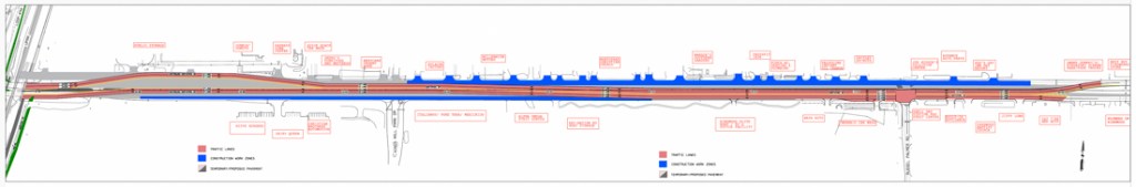
9/8/25 – In the quest to build an all-weather evacuation route from Kingwood, contractors for the Northpark Drive expansion project will switch traffic to accommodate new phases of construction.
Beginning September 9th at 9pm, Harper Brothers Construction will shift westbound traffic between NorthPark Christian Church and Loop 494 to the newly constructed westbound lanes.
The existing eastbound traffic lanes will also shift onto the previous westbound traffic lanes from Loop 494 to RecNation RV & Boat Storage.
Both switches are east of the railroad tracks. See below.
Greatly reduced. For a full-size, high-res PDF with better readability, click here.
During this phase of work the contractor will install additional drainage and reconstruct the existing roadway. These traffic shifts should last approximately four months.
Two utility pipelines on diagonals still remained at noon todaybut should be removed this week…with luck.
Photos from 9/8/25
I took the following photos today. They show the state of construction along Northpark from east to west. And they should help put the map above into perspective.
Looking W at Eastern end of Phase 1 (Project T-1013) toward US59. Phase II will start behind camera position and go slightly past Woodland Hills Drive (far enough for turn lanes).Contractors have demolished and removed all the concrete from the old westbound lanes (right).They continue to install drain pipes under the cleared lanes, heading east (behind the camera position).Working from the bottom up. Drain pipes being installed before surface work.
Storm-sewer crews are installing drainpipe on westbound Northpark east of 494.
After they install drainage, other crews prepare the sub-grade before pouring concrete.The sidewalk and driveway crews come next. This is near the entrance to Kings Mill. Bottom left.
The road splits at the start of the bridge (not yet built) that will eventually carry traffic over the railroad tracks and Loop 494.
On the left, note streets going in for a new development called the Enclave. It will have 100 homes on 10 acres.
Also note preparation of the sub-grade (above and below) for new surface lanes on the left that will be built between the bridge and the Enclave.
Rebar has been placed for another concrete pour as you approach the railroad tracks and Loop 494 (top of frame).Stockpiled 60″ steel drain pipes for boring under tracks.Contractors are mobilizing this week to resume boring under the tracks (from right pit to one in center).
After the two utility conflicts are removed, all bore activities should finish within two weeks.
West of Loop 494
Looking W from Loop 494 toward US59. Contractors will soon start preparing the sub-grade and paving the dirt area in the center where old lanes were removed.The Exxon Station at 59 will reportedly lose an island of pumps and part of its canopy.Grading of the north detention pond should start the week of 9/15 and continue for at least two weeks.Ditto for the south detention pond.
It’s not clear yet whether those detention ponds will be ready or this Christmas. After grading, several steps remain. They include:
Placement of a liner to retain water in the ponds
Drilling a well
Filling the ponds
Landscaping
Wouldn’t that be a wonderful gift for the community if the ponds could be ready by Christmas!
https://i0.wp.com/reduceflooding.com/wp-content/uploads/2025/09/20250908-DJI_20250908122201_0017_D.jpg?fit=1100%2C619&ssl=16191100adminadmin2025-09-08 17:06:572025-09-10 17:02:17Northpark Drive Lane Switches Scheduled for This Week
9/6/2025 – On August 26, 2025, Harris County Flood Control District (HCFCD) transmitted an update to Commissioners Court on the release of new flood insurance rate maps. The update showed the release date slipping yet again. This makes at least the seventh postponement in four years.
The amount of time it’s taking FEMA to vet the maps may now exceed the time it took HCFCD to create the maps.
Visual Chronology of Updates
Below are seven screen captures that I took from MAAPnext’s website, presentations and transmittals through the years.
On 11/30/2021, the maps were going to be available to the public by Spring, 2022.But by Jan 26, 2022, the release had slipped to summer or fall that year.
By November 2022, the release was an unspecified date sometime in 2023, a much larger window.
On June 8, 2023, the release date window widened to two full years. Three months later, on Sept. 6, 2023, the release had been firmly pushed to 2024.The update presented at the 8/26/25 Commissioners Court meeting shows release of maps in early 2026, but……copy on the MAAPnext project-schedule page says “end of 2026.“
Keep in mind that it can take another 2-3 years for the preliminary maps to go through public review, public comment, appeals and become the final “effective” maps.
Many different groups depend on having the best information available. They include, but are not limited to:
Developers
Home builders
Home buyers
Home sellers
Lenders
Realtors
Politicians
The National Flood Insurance Program
In some cases, their interests may be diametrically opposed.
Delays may help some in the short term. However, in the long term, sound public policy must rest on data, not delusions.
HCFCD does not have to wait for FEMA to release MAAPnext data. The District could make it publicly available with the flip of a software switch today.
If FEMA wants to change something, HCFCD can modify its maps later. But at least in the meantime, all those interests above could make decisions based on the best available data.
Harris County Appraisal District and HAR.com report that 85,163 single-family homes sold in Harris County in 2024. The same HAR report gives a total dollar volume of $41.1 billion in 2024 for single-family home sales in the Houston region. And those numbers do noteven include townhomes, condos, or commercial real estate.
I would urge anyone who suspects they may have purchased a home in a floodplain that isn’t currently shown in a floodplain – or anyone considering purchasing a home – to complain to the Texas Board of Professional Engineers and Land Surveyors.
If they start yanking licenses, we may quickly see maps more current than those developed 24 years ago after Tropical Storm Allison.
Posted by Bob Rehak on 9/6/25
2930 Days since Hurricane Harvey
The thoughts expressed in this post represent opinions on matters of public concern and safety. They are protected by the First Amendment of the US Constitution and the Anti-SLAPP Statute of the Great State of Texas.
https://i0.wp.com/reduceflooding.com/wp-content/uploads/2025/09/20250906-7.18.35-PM.jpg?fit=1100%2C677&ssl=16771100adminadmin2025-09-06 21:05:342025-09-06 23:49:09Flood Insurance Rate Maps Slip for Fourth Straight Year
9/5/25 – The Texas Commission on Environmental Quality (TCEQ) has completed investigating exposed pipelines carrying highly volatile liquids at a sand mine in Porter operated by Texas Frac Sand Materials Inc.
Exposed HVL pipelines in utility easement near Caney Creekphotographed on July 24 and August 14, 2025
TCEQ documented the pipeline issue and referred it to the Railroad Commission of Texas, which regulates pipelines in the state. As of this writing, it is unclear whether the pipelines remain exposed.
Other Alleged Violations Found
While at the mine, the TCEQ investigator noted other alleged violations that are now part of an active enforcement action. Specifically, the report notes that the operator had not stabilized the entrance. Nor had the operator installed structural controls along the bridge that crossed White Oak Creek.
In addition, the investigator noted breaches in the dikes of the mine’s southernmost pit. One came in from White Oak Creek and the other flows out to Caney Creek.
Previous Alleged Violations
The report also notes that a 2023 investigation found three previous issues at the mine. They included failure to:
A 2024 investigation noted that the vegetative control issue had been resolved. However, the other two issues remained and were referred to the TCEQ’s enforcement division.
A followup investigation in 2024 noted failure to prevent the unauthorized discharge of process wastewater into waters of the state.
Other Problems Dating Back Before Harvey
Prior to Texas Fracsand operating the mine, Triple PG Sand Development (the property owner) operated it.
Triple PG also had multiple run ins with the TCEQ. One resulted in a million dollar lawsuit.
The lawsuit, which the state attorney general lodged on behalf of the TCEQ, has been delayed for six years by legal maneuverings. It began in October 2019 and is still waiting to come to trial in Travis County. See Case D-1-GN-19-007086.
The lawsuit alleged uncontrolled and unauthorized release of process wastewater from the mine’s dredging pond into the headwaters of Lake Houston. And it sought $1.1 million in damages plus $25,000 per day that the releases continued. The text of the lawsuit details other alleged violations dating back to 2015. However, Montgomery County Appraisal District records show that Triple PG acquired the property in early 2017.
In November 2019, Triple PG began a flimsy repair of its dikes. The repair later washed out and had to be redone. Then that repair washed out, too.
Pollution from the mine even became an issue in Tony Buzbee’s campaign for Houston Mayor.
The thoughts expressed in this post represent opinions on matters of public concern and safety. They are protected by the First Amendment of the US Constitution and the Anti-SLAPP Statute of the Great State of Texas.
https://i0.wp.com/reduceflooding.com/wp-content/uploads/2025/07/20250724-DJI_20250724140935_0601_D.jpg?fit=1100%2C619&ssl=16191100adminadmin2025-09-05 15:51:542025-09-05 16:20:37TCEQ Investigates Exposed Pipelines at Porter Sand Mine, Finds More Alleged Violations
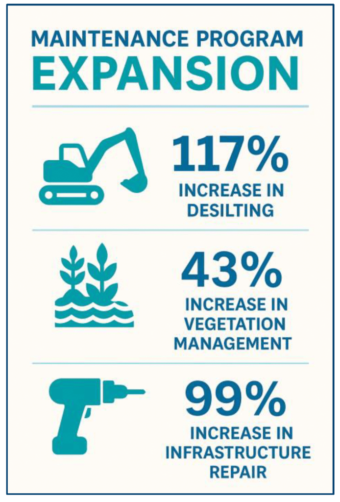
9/4/25 – Harris County Flood Control District (HCFCD) issued an update on its maintenance activity to Commissioners Court in a transmittal on 8/26/25. Without explaining exactly where (geographically) the money went, the 7-page overview details HCFCD’s increase in activity enabled by its November 2024 “Proposition A” maintenance tax.
The tax provides another $100 million annually dedicated to maintenance. See some of the highlights below.
Developing a Sustainable Infrastructure Practices Program
Scaling maintenance programs while addressing a Deferred Maintenance Backlog and expanding Citizen Services
Developing an Asset Management Program
It hopes to meet citizen’s maintenance expectations by Fiscal Year 2028.
Since the start of their “Major Repair and Replace” program, HCFCD has designed 65 projects, constructed 10, and completed two.
The number of “Moderate Repair and Replace” projects handled through “on-call contracts” increased from 3 to 11 so far this year. Spending on that program has nearly tripled from $2.7 million to $7.8 million.
New Equipment
HCFCD purchased $17 million of new equipment, including excavators, dozers, vehicles and chainsaws. The District has yet to take delivery of all the equipment but says, “This investment strengthens both preventive maintenance and repair efforts, allowing crews to work more efficiently and respond quickly to emerging needs.”
The District hopes to receive most of the equipment in Fiscal Year 2026.
Desilting Has Largest Percentage Increase, But…
In addition, HCFCD’s channel desilting efforts increased by 117%. Out of 2500 miles of channels in 23 watersheds, HCFCD went from desilting a total of 24.6 miles of channels to 53.5 miles. That’s a little more than 2% of the total mileage. But it is double the previous 1%.
The update does not address needed maintenance intervals. I hope that number increases. At that rate, it will take half a century before crews return to your channel.
Recruiting Challenge
Finding employees, especially equipment operators, to scale up operations has been challenging. Of the 54 new hires authorized by Commissioners Court, 22 positions have been filled and 11 offers are pending. “Recruiting has been challenging,” says the update. 24 job offers had to be withdrawn for various reasons.
Fast-Action Funding Grows by $330,000
Funding for HCFCD’s Fast Action Service Teams, which handle community concerns such as debris and fallen trees that block channels, has already increased from $1.04 million per year to $1.36 million per year.
New Computer System
To help run its Asset Management program, HCFCD is digitizing its computer systems and assets. The District hopes to complete and deploy a new Computerized Maintenance Management System by the end of 2026.
Consultant Search
HCFCD also is seeking a consultant to help scale its maintenance programs and address the backlog of deferred work. It hopes to conclude the review process, which started in May, by early Fall 2025.
Looking Ahead
HCFCD’s report concludes with these encouraging words. “The progress outlined in this report demonstrates the tangible benefits of sustained investment in maintenance and the significant return Proposition A has delivered for Harris County residents.”
“By combining new funding with strategic scaling of staff, equipment, and operational practices, the Flood Control District is rapidly addressing decades of deferred maintenance while laying the foundation for a proactive, resilient system.”
“As the Maintenance Matters program continues to grow, the Flood Control District remains committed to transparency, accountability, and community partnership. FY2026 will mark another year of historic investment, ensuring that Harris County’s flood risk reduction infrastructure is not only restored and maintained, but strengthened to serve future generations.”
For More Information or to File a Maintenance Request…
9/3/25 – A new study by City of Houston Controller Chris Hollins found that Houston is underprepared for disasters. FEMA ranks Harris County #1 nationally for hurricane risk. However, Houston has roughly half the disaster reserves of other cities studied and half the amount recommended by Government Finance Officers Association (GFOA) Best Practices.
It reviews the City’s disaster reserve funding policies and economic vulnerabilities that limit flexibility in disasters.
It also proposes strategies to make Houston more financially prepared for future disasters.
Houston Has History of Disasters
Houston has faced 25 FEMA-declared disasters since 1983 with frequency rising sharply during the last decade.
From Page 8
FEMA gives Houston/Harris County and Miami/Dade County the highest possible hurricane risk scores – a perfect 100. The scores reflect expected losses, social vulnerability and community resilience.
In recent years, this area exxperienced the second and tenth costliest storms in U.S. history (Harvey and Ike).
Economic Vulnerabilities
The report next looks at the causes of Houston’s economic vulnerability. They include:
Structural budget deficits
Property tax cap
Sales tax volatility
Public safety costs
State legislative policies
After a temporary boost from the American Rescue Plan Act (ARPA) during Covid, Houston’s disaster fund will experience some of the sharpest declines in history.
From Page 11
A number of state and local laws, such as property tax caps, limit Houston’s revenue. Police, fire and debt consume 75% of the City’s budget, leaving little flexibility.
Disaster Reserve Funding
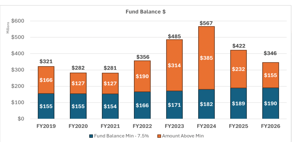
In 2024, the City’s disaster reserve fund peaked at a record high – $385 million above the minimum mandated by policy. However, that surplus has been drawn down to close budget gaps.
From Page 16
At present, Houston’s reserves lag behind peer cities and recommended best practices. The target as a percent of the total general fund in:
Houston is 8-9%
Dallas 19-20%
San Antonio 15-16%
Miami 20%
GFOA Best Practices 16.7%+
Recommended Policy Changes
The report recommends:
Raising the minimum fund balance to strengthen reserves
Raising the allocation percentage to strengthen the City’s safety net
Allocating excesses above the minimum to create a consistent funding mechanism
Clawing back dollars not dedicated to grow reserves without raising taxes
Separating economic and disaster uses for special funds to preserve disaster funds during economic downturns.
Posted by Bob Rehak on 9/3/25
2927 Days since Hurricane Harvey
https://i0.wp.com/reduceflooding.com/wp-content/uploads/2025/09/Fund-Balance.png?fit=1786%2C976&ssl=19761786adminadmin2025-09-03 21:13:162025-09-03 21:16:15City Controller Finds Houston Underprepared for Disasters
9/2/2025 – The following is reprinted from Houston District E City Council Member Fred Flickinger’s newsletter. It relates to the purchase of backup generators to keep critical city facilities such as sewage treatment plants, running when power goes out during storms. This issue has plagued the Lake Houston Area. Some of the money below will still go toward generators, just not as much.
“In August, City Council approved the submission of a plan to the U.S. Department of Housing and Urban Development for how the City will allocate nearly $315 million in federal disaster recovery funds from the Derecho storm and Hurricane Beryl last year. Council Members Huffman, Peck, and I co-authored a joint op-ed explaining our vote against the proposed plan. We submitted this to the Houston Chronicle for publishing, but they refused to do so. You can read what we wrote below:
Why We Voted Against the $100 Million Home Repair Amendment
As Houston City Council Members, our responsibility is to make decisions that improve the quality of life and safety of Houstonians in the most responsible and fiscally prudent way possible. That’s why, when faced with a $315 million disaster recovery action plan, we could not support an amendment that would have redirected $50 million away from critical disaster recovery tools and into additional home repair funding.
The amendment proposed raising home repair funding from $50 million to $100 million, split evenly between single-family and multi-family homes. While the intention was noble, the extra dollars would have come from the budget set aside for generators at essential city facilities. These generators power community centers, sewage lift stations, and police and fire stations—places that become lifelines when disaster strikes.
We are deeply sympathetic to Houstonians whose homes were damaged by storms. But we voted no for three key reasons:
Generators Are Vital for Disaster Recovery
When the power goes out, safety risks increase dramatically. Community centers must be able to provide shelter, and first responders need reliable facilities to do their jobs. We must continue to make sure that our water and wastewater plants have electricity to provide these services as well.
A University of Houston Hobby School of Public Affairs survey found that 88% of registered voters in Harris County are concerned about outages lasting more than a day this summer. That is not an abstract fear—it is based on lived experience. For the first time, we have an opportunity to obtain generators, and cutting the funding jeopardizes public safety at the very moment Houstonians need it most.
The Home Repair Program is Inefficient
Currently, the program doesn’t just fix storm damage—it often rebuilds entire homes. Instead of only fixing storm damage, the City pays for repairs needed in the rest of the house, whether the damage was due to a storm or not. What might begin as a small roof repair can become a complete home rebuild. This drives the average cost per home to about $200,000, per Mayor Whitmire’s office.
For $50 million in single family home repairs, that would mean that we are only able to assist approximately 250 homes. In a city of 2.3 million people, while incredibly impactful to the small number of people receiving the benefit, it is negligible for the rest of the population. With smarter policies, we could stretch these dollars further and help more people. Until those changes are made, pouring in more money only perpetuates inefficiency.
Furthermore, the multi-family housing aspect of this program is even more problematic. Multi-family housing essentially means apartment complexes. While we must make sure that people have safe places to live, apartment complexes are businesses that almost without exception should have had insurance for protection.
Businesses are crucial to our economy, and apartments are no exception; however, paying to essentially remodel an apartment complex with this money does not help prepare anyone for future storms.
The Actual Need is Unclear
Damage estimates are made immediately after storms, but we are now more than a year out from the derecho and Hurricane Beryl. Many homeowners and multi-family owners have already completed repairs. Based on past storm data, the final need may be much lower than $100 million.
The City of Houston still has $40 million in home repair funding from Winter Storm Uri that Houstonians can access for home damages that must be addressed as well. Scaling up to manage a program of this size could require additional staff and new systems—raising the risk of falling short on federal requirements and jeopardizing future HUD funding.
We have already seen this exact scenario play out in the aftermath of Hurricane Harvey. Although we know Mayor Whitmire and his administration will handle this process with care and accuracy, we do not know yet the scale on which we would need to increase this program in order meet the demands.
We continue to support Mayor Whitmire’s commitment towards disaster recovery and response, and he and his team have done a phenomenal job in recent storms to make sure that Houstonians were cared for. He faced a difficult task in shaping this action plan, and we commend him for listening to residents who called for home repair assistance.
His decision to shift $50 million toward repairs—when the original plan had none—was a fair and thoughtful compromise. At this stage, however, $100 million does not advance our goal of preparing Houston for disasters. Given the choice of repairing 250 homes and an indeterminable number of private apartment complexes versus addressing needs for 2.3 million people, we chose the latter.
We remain committed to supporting Houstonians in times of crisis. But we must do it in a way that is sustainable, efficient, and does not undermine other critical recovery tools.”
Posted by Bob Rehak on 9/2/25 based on CoH Council Member Flickinger’s September Newsletter
2926 Days since Hurricane Harvey
https://i0.wp.com/reduceflooding.com/wp-content/uploads/2024/04/COH-CM-Fred-Flickinger-at-KWCC.jpg?fit=1100%2C733&ssl=17331100adminadmin2025-09-02 19:30:212025-09-02 19:50:17Flickinger Explains Vote on Disaster-Recovery Funds
2/16/26 – Update – Mealer now endorsed by President Trump – Two local Republicans have announced their intention to run for Congress in the newly redrawn U.S. Congressional District 9. Alexandra Mealer, who ran for Harris County Judge in the 2022 election, will square off against State Representative Briscoe Cain in a primary. President Trump has endorsed Mealer.
I am also strongly endorsing Alex Mealer based on her distinguished background and her continued commitment to improving flood-mitigation infrastructure in our region.
Mealer by a reminder of the depth of flooding during Hurricane Harvey at Torchy’s Tacos in Kingwood Town Center
Alex Mealer’s Distinguished Background
Mealer graduated from West Point, then completed advanced training at the Naval Explosive Ordnance Disposal (EOD) school. As a young lieutenant, the Army selected her ahead of her peers to form a new EOD company for a planned surge in Afghanistan. She prepared her team in half the time usually required by the Army then deployed to a forward operating base in Afghanistan.
While there, Mealer was again selected ahead of her peers to lead the EOD Headquarters Company, consisting of 600+ personnel deployed to 40+ locations throughout Afghanistan. For her 14-month deployment, Mealer was awarded the Combat Action Badge and Bronze Star Medal.
After honorably completing military service, Mealer obtained an MBA from Harvard Business School and a JD degree from Harvard Law School. She then went on to leverage her degrees as an oil & gas investment banker in Houston. She specialized in capital markets and merger/acquisition consulting in the oilfield services sector.
In 2021, Mealer began her campaign against incumbent Harris County Judge Lina Hidalgo. She shocked political insiders by winning a nine-way primary in which opponents outspent her 3:1. She went on to win the Republican nomination in a landslide runoff victory.
In the general election, Mealer received approximately 45,000 more votes than any other Republican on the ballot. But the first-timer narrowly lost to Hidalgo. She secured more than 49% of the vote in the nation’s third largest county (the size of 6 Congressional Districts).
Currently, she works as a VP for a private financial institution and serves as a representative of 14 cities on the METRO board where she also chairs the public safety committee.
A Force of Nature
I first met Mealer when she ran for county judge in 2021. She spent days studying flood issues in the Lake Houston Area and meeting with area residents. She and I have stayed in touch ever since. We frequently discuss Harris County flood issues, many of which originate upstream.
Mealer has seemingly inexhaustible reserves of energy. Even after her razor-thin loss in the county judge race, she never gave up trying to help the people of Harris County.
Within one day after her narrow loss, she started working with a legal team and subject-matter experts to craft legislation that could have potentially expanded the geographic scope of the Harris County Flood Control District.
The idea? Create a regional Resiliency District that could someday grow as large as the entire San Jacinto River Basin. Then she pushed for it in Austin, where State Rep. Dennis Paul ultimately led the effort to reform and expand the Harris County Flood Control District.
Even though it didn’t pass this session, the idea still has legs. There is a growing recognition that people must work together across jurisdictional boundaries if they will ever truly address flooding problems.
A map of the new CD9 shows that the district stretches from Cleveland to the ship channel and Port of Houston. It includes refinery complexes in Pasadena, Deer Park, and Baytown. If CD9 were a country, it would have approximately the 20th largest economy in the world, according to Mealer.
The new CD9 also includes the East Fork San Jacinto, Luce Bayou, the Luce Bayou Inter-Basin Transfer Project, the Trinity River, the Lake Houston Dam, Colony Ridge, all of Liberty County and major parts of Harris County.
From north to south, water weaves through CD9 into CD2 and back into CD9.
Map of new Congressional District 9 (shown in blue)
Any flood-mitigation solution must recognize the interdependence of these areas for their collective safety. CD9 cannot be operated independently as a fiefdom. Cain’s vote on the Lake Houston Drainage District Bill would lead one to conclude he just doesn’t understand that. Or if he does, he doesn’t care.
CD9 is Houston’s economic gateway to the world. It needs world-class infrastructure.
Lake Houston Dam and Harris County Flood Projects
The inclusion of the Lake Houston Dam in the new CD9 will put major funding and leadership responsibilities on the new congressional representative. The City just started a major repair project on the dam. Houston has also been studying ways to add more floodgates for several years now.
A strong representative in CD9 could help with those projects. A strong representative could also help Harris County reach well beyond the 2018 flood bond.
Heavy vehicular traffic near refineries places exceptional stress on infrastructure. And in military fashion, Mealer has made infrastructure her mission.
She and I spent most of the day yesterday scouting drainage channels plus dredging and maintenance needs in the Lake Houston Area all the way down to Crosby and Barrett Station. At one point, the rain started coming down so hard, we got soaked.
Mealer caught in downpour at Bens Branch and Kingwood Drive.
Mealer smiled through it all and pushed our recon patrol forward for another four hours. That was on a Sunday. On a major holiday weekend.
I don’t know about you. But I feel this area needs that kind of committed leadership. And that’s why I’m endorsing her.
Posted by Bob Rehak on 216/26
3093 Days since Hurricane Harvey
https://i0.wp.com/reduceflooding.com/wp-content/uploads/2025/09/20250831-DSC_3263.jpg?fit=1100%2C733&ssl=17331100adminadmin2025-09-01 10:47:262026-02-17 16:09:17Why I Endorse Alexandra Mealer in new Congressional District 9
8/30/25 – On the eighth anniversary of Hurricane Harvey, more than 400 residents crowded into the Kingwood Community Center to hear Congressman Dan Crenshaw talk. Unfortunately, a group of unruly agitators wouldn’t let the Congressman speak about flood mitigation to an audience whose lives had been upended by flooding.
They kept shouting questions about random, unrelated topics, such as lactation consulting. And before Crenshaw could answer one question, attackers would cut him off with another. Sometimes the attackers even stepped on each other.
It appeared as though the provocateurs were trying to get the police to eject them. That would have given them ammunition to slime Crenshaw further on social media.
The experience was an hour-long dystopian view of mob rule. Disruption, disturbance and disparagement replaced civilized discourse and debate. The volume of protesters’ voices drowned out Crenshaw’s attempts to illuminate issues.
That’s a real shame because he has a master’s degree in public administration from Harvard. Crenshaw is smart. Plus…
He has a deep understanding of issues and a gift for explaining them in ways that help people find common ground.
Bob Rehak
Dan Crenshaw patiently addresses protesters at Kingwood town hall
Shouts Overpower Microphone
Even though Crenshaw had a microphone, I had trouble hearing him. So, for those who attended hoping to hear what Crenshaw has done for flood mitigation in the area, here is partial text of his remarks obtained later from his staff.
Crenshaw’s Remarks on Flood Mitigation
“Through my work in Washington, I’ve been able to pull down federal dollars to help our local communities here in Lake Houston.”
“As you probably know, earlier this year we finally wrapped up a project that I had advocated for since I took office. The complete restoration of Lake Houston to pre-Harvey conditions. To date, over $150 million of federal funds have been used to dredge Lake Houston. The last $30 plus million project was completed near the convergence of the East Fork, West Fork and the lake.”
“I look forward to seeing the City maintain the lake with the newly approved Lake Houston Dredging District. This project was a long-fought effort by Charles Cunningham, Fred Flickinger and Twila Carter. It was unfortunate that my opponent, Steve Toth, voted against helping this community.
“While the Lake Houston Dam is long overdue, I feel confident that we are on a good path and I am committed to expediting any federal permits required to get this project completed. For updates on the project, you should subscribe to Fred Flickinger’s newsletter.”
“Some other projects in the area that I secured Community Project Funding for are as follows:”
Purpose: The project aims to decrease flooding elevation within the San Jacinto watershed. It supplements funding obtained in previous years. [See below.]
Designed as a wet-bottom basin with a permanent pool of water and constructed with native wetland vegetation and features, this stormwater detention basin will function to treat and clean stormwater. The permanent pool of water will settle out solids, while the native vegetation will provide habitat for aquatic species that filter and clean stormwater.
FY24 Community Projects Signed into Law
Ford Road Improvement Project – $7 million
Purpose: This request will support Ford Road improvements from US 59 in Montgomery County to the Harris County line. The current road is undersized and serves as one of only three evacuation routes for the Kingwood area. Commissioner Gray is currently constructing this project.
Kingwood Diversion Channel – Walnut Lane Bridge Project- $4 million
Purpose: The project includesthe widening and reconstruction of Walnut Lane Bridge in Kingwood. This bridge, in its current configuration, will restrict flood flows unless widened to accommodate the future expansion of the Kingwood Diversion Channel currently being designed by the Harris County Flood Control District.
Taylor Gully Channel Conveyance Improvements Project-$1.75 million
Purpose: This project is designed to reduce flood risk in the Kingwood area. This project will create a detention basin and improve stormwater conveyance to minimize flood risks. Engineering studies show that completion of this project will result in substantial reductions in flooding along Taylor Gully. The studies show that this project will remove the 100-year floodplain from over 115 acres of flood area and from 276 structures.
FY23 Community Projects Signed into Law
Lake Houston Dam Spillway Project – $8 million
Purpose: This recently completed project reinforced the existing dam structure. The aging structure needed reinforcement and a project to replace this structure is underway. The dam gates will not be using this structure.
Woodridge Stormwater Detention Basin Project – $5 million
Purpose: The project involves creating a detention basin to alleviate flood risks in the Kingwood area. This project is critical for flood mitigation efforts in the district.
Harris County Municipal Utility District (HCMUD) 468 Stormwater Detention Basin Project-$2 million
Purpose: This project is for the excavation of a stormwater detention basin located in the Cypress Creek watershed. The Cypress Creek watershed is highly developed and has a lack of regional stormwater detention basins for flood mitigation. This project is critical for flood mitigation efforts in the district and provides upstream detention to Kingwood
FY22 Community Projects Signed Into Law
Kingwood Diversion Channel – $1.6 million
Purpose: The Kingwood Diversion Channel improvements are proposed to divert stormwater runoff from the Bens Branch channel to lower the risk of structural flooding along the portion of Bens Branch within the Kingwood area. This project will also provide capacity to allow for future local City of Houston neighborhood drainage improvements to outfall into the Kingwood Diversion Channel.
Taylor Gully Channel Conveyance Improvements – $1.6 million
This project will mitigate flooding on the north side of Kingwood.
TC Jester Stormwater Detention Basin Project – $9.96 million
Purpose: This request is for TC Jester Detention Basin, which is a stormwater detention mitigation project within the Cypress Creek Watershed that is intended to address current flood damage reduction needs within the Cypress Creek Watershed. This project will provide upstream detention to Kingwood.
Westador Stormwater Detention Basin Project – $8.85 million
Purpose: This project will also provide upstream detention to Kingwood.
Each of these wins – border security funding, energy permitting, flood infrastructure – came from listening to our community and then acting decisively.
Crenshaw Deserves Even More Credit
Crenshaw didn’t say it, but the money he helped obtain for the Woodridge and Taylor Gully Projects also helped those projects qualify for $33 million dollars in CDBG-MIT grants. Harris County Flood Control District obtained those through the Texas General Land Office and the U.S. Department of Housing and Urban Development.
The thoughts expressed in this post represent opinions on matters of public concern and safety. They are protected by the First Amendment of the US Constitution and the Anti-SLAPP Statute of the Great State of Texas.
https://i0.wp.com/reduceflooding.com/wp-content/uploads/2025/08/20250828-DSC_3186-2.jpg?fit=1100%2C733&ssl=17331100adminadmin2025-08-30 18:16:032025-08-31 05:34:04Protesters Disrupt Crenshaw Town Hall in Kingwood on Harvey’s 8th Anniversary