Six hundred and thirty-seven days after Hurricane Harvey, the Texas Legislature finally passed and funded a massive flood-relief bill, Senate Bill #7 (SB 7), sponsored by State Senator Brandon Creighton. The lengthy delay between Harvey and the bill’s passage underscores the need for Creighton’s bill.
Need for Faster Mitigation
Few government entities, it seems, budget for emergencies. So when a tragedy like Harvey happens, cities and counties scurry around looking for small grants. They use those to hire consultants to apply for other small grants that provide matching funds for even bigger grants from FEMA.
There’s even a two-step process to get on the list for grant consideration at the Federal level. You don’t just apply to FEMA or HUD. First, you have to file an application with the TDEM (Texas Division of Emergency Management, a part of DPS) before you can file an application with FEMA.
Most of the begging goes on behind the scenes, out of sight to the average citizen. The fact that the City or County has applied for a grant falls below the threshold of newsworthiness in most cases and so remains invisible to all but insiders. Once someone approves the grants, lengthy permitting processes further delay construction. It take years for a mitigation project to get to the construction phase. That’s when a project becomes newsworthy again.
Changing a Frustrating Process
This is why, to the average citizen, the pace of flood mitigation appears maddeningly and frighteningly slow. Important projects, such as additional dredging, gates for Lake Houston, and upstream detention, seem perpetually mired in government red tape.
The passage of Senate Bill (SB) 7 and SB 500 could help change that. The Senate and House have passed both bills, which are on their way to Governor Abbott’s desk. State Representative Dan Huberty says the governor supports both bills and that his signature is certain.
Here’s what they do:
SB 7 sets up several different funds that will make it easier to launch flood mitigation projects.
SB 500 appropriates the money for the funds in SB 7.
Provisions in SB 7
SB 7 relates to flood planning, mitigation and infrastructure projects.
Article 1 in SB 7 provides money for: flood control planning; preparation of applications for regulatory approvals; and development of engineering plans/specifications for flood mitigation and drainage projects.
Article 2 establishes a special flood infrastructure fund to make loans (at or below market interest rates) for flood projects. It can also provide grants that provide matching funds to poorer political subdivisions that make them eligible to participate in federal programs.
Article 3 amends the state Water Code relating to the Texas Infrastructure Resiliency Fund by establishing special accounts for Floodplain Management, Hurricane Harvey, Federal Matching projects, and Flood Plan Implementation.
Provisions in SB 7 encourage cooperative planning and financing of projects across political boundaries. Those provisions support regional flood mitigation projects through the Flood Infrastructure Fund. That should be especially helpful in the Lake Houston area where mitigation projects affect multiple counties and cities.
SB 500 Provides the Funding
SB 500 is an appropriations bill. It provides funding SB 7 and other items. It appropriates out of the state’s economic stabilization (rainy day) fund:
$273 million to provide matching funds for Hazard Mitigations Grants administered by FEMA.
$365 million to provide matching funds for Public Assistance Grants administered by FEMA.
Out of those two sums, it also appropriates $30 million that may only be used to provide a grant to Harris County to remove accumulated silt and sediment at the confluence of the San Jacinto River and Lake Houston, i.e., The Mouth Bar! That came from an amendment to SB 7 proposed by State Representative Dan Huberty when the House considered the Senate Bill.
It also provides, among many other things:
$47 million for community assistance
$793 million for flood infrastructure projects (drainage, flood mitigation and flood control projects)
$857 million for the Texas infrastructure resiliency fund
$13 million to the Lone Star College system for expenses related to Hurricane Harvey.
Rep. Dan Huberty says that since SB 500 is a supplemental appropriations bill, money from it should be available immediately, as soon as the Governor signs it.
A Big Thank You to Creighton and Huberty
The 85th legislature adjourned less than three months before Harvey inundated South Texas. That delayed legislative action two years. As a result, ever since Harvey, local officials have scrambled to organize and fund flood mitigation projects. The passage of these two bills should speed that process up by providing seed money for planning, grant writing, and matching funds. Thanks go to Senator Brandon Creighton and his staff for responding to the need and pushing these bills through the legislature. Thanks also go to Representative Dan Huberty for earmarking money for mouth bar dredging.
SB 500, a supplemental appropriations bill approved last weekend contains $30 million to help dredge the mouth bar on the West Fork of the San Jacinto.
With West Fork Phase One dredging rapidly winding down, hopefully the addition of $30 million to any money contributed by the City and FEMA will enable dredgers to restore conveyance of the West Fork.
Finally, we should give a big thank you to all of you who wrote letters in support of these two important pieces of legislation.
Posted by Bob Rehak on 5/28/2019
637 days since Hurricane Harvey
https://i0.wp.com/reduceflooding.com/wp-content/uploads/2019/01/Harvey-SanJac_437-cropped-e1775595968700.jpg?fit=1100%2C456&ssl=14561100adminadmin2019-05-28 12:54:122019-05-28 13:07:03Passage of SB 7 and SB 500 Should Speed Up Flood Mitigation Projects
Map by LJA Engineering shows natural drainage. Purple outline shows boundaries of Figure Four Partners’ Woodridge Development.Dark gray outline shows extent of drainage area for Taylor Gully.All drainage in A-E flows to F.
According to residents in Elm Grove and North Kingwood Forest, their homes never flooded before May 7th, 2019, including during Hurricane Harvey. Then bulldozers cleared the 262 acres north and west of them to create a new subdivision called Woodridge Village.
Reconstruction of Events
After talking with dozens of residents, mapping flood damage, reviewing flood videos, and photographing the aftermath, I think the following happened on May 7, 2019.
A large, long, linear ditch ran along the county line. Approximately half of this ditch (labeled S1 by the developer) bordered Sherwood Trails. Contractors had fully excavated the ditch but not fully finished it. The other half of the ditch that bordered Elm Grove did not yet have:
Red labels and circle have been added to approved drainage plan to make it easier to follow this discussion. Small black arrows indicate direction of flow.The 29-acre triangular area labeled N2 actually belongs to Montgomery County, which started cleared most of the land between 2006 and 2008.
Here’s an enlargement of the crucial S2 detention area that shows the flow. All water from the northern section of Woodridge, drains to the part of Taylor Gully running from the triangular detention area N2 on the left toward the upper right.
Note two u-turns made by the water within the space of 200 feet.
Several things happen when the water reaches the upper right.
Most of the runoff is forced to make a 120 degree right turn.
It’s joined by more water flowing south along the eastern edge of the property to the north, and the gas pipeline easement north of North Kingwood Forest.
All of that flows into a much smaller ditch…
…that narrows down into a 3′ pipe…
At that point, it is supposed to make another 90-degree turn into…
…a grassy-lined channel that conveys the water into S2
…where it mixes with stormwater from S1…
…and flows through a box culvert…
…into Taylor Gully where it’s joined by water shooting out of the 3′ pipe.
Here’s an even closer view of how all that works.
The Big Lebowski Connection
In the movie The Big Lebowski, Walter says to The Dude, “That’s right, Dude, the beauty of this is its simplicity. Once the plan gets too complex everything can go wrong.” And it did.
Of course, it was complicated by the facts that:
Most of S2 had not yet been excavated.
The grassy-lined channel to convey water from the upper part of Taylor Gulley into S2 had also not yet been excavated.
A reinforced concrete box culvert had been installed to reduce the outflow into the lower part of Taylor Gully. That backed water up.
A second reinforced concrete box culvert had not yet been installed farther up the ditch that might have held back some of the water that flowed into Elm Grove.
Critical Corner of Chaos
Jeff Miller, an Elm Grove resident who came within inches of flooding dubbed this corner of the development the “Critical Corner of Chaos.”
Jeff Miller schematicshowing series of problems near area that flooded.To his list, I would add the culvert across the ditch by the road that did not yet exist.
Photographs of debris patterns left in grass near the diagonal part of Taylor Gully show that water started overflowing the banks as far west as the road that crosses the ditch. From there, it headed straight south toward Elm Grove.
Debris from flood caught in grass high above ditch indicates that water went out of banks near the proposed street that connects the north and south sections of Woodridge.From here, the water headed overland toward Elm Grove in the background.
Also, when water started to make that 120 degree turn at the top of Miller’s diagram, it overflowed the banks into North Kingwood Forest. Part of the water also split off on the other side of the ditch and headed toward Elm Grove. The constrictions caused by:
Flowing from a large ditch into a smaller ditch
Flowing from the small ditch into a 3-foot pipe
Not enough detention excavated
Restricted outflow at the box culvert
…all forced water to flow into surrounding neighborhoods and down streets. Overland sheet flow added to street flooding already present raised the level of the water enough to enter at least 196 homes. The main paths that the water took looked something like this.
The red line shows the location of the buried 3′ pipe. Blue lines indicate the MAIN flow of water. Note, it also spilled out onto other side streets. This map shows the main flow, not the extent of flooding.
Current and Future Concerns
It’s been three weeks since the flooding. As the site continues to take shape, and as we officially enter hurricane season this week, several things should concern residents.
Rebel Contractors is far from having all the detention ponds excavated.
The dirt they have excavated is being used to elevate Woodridge above Elm Grove.
The drainage scheme LJA envisioned at the southeastern corner of the subdivision may not be sufficient in future heavy rains to prevent flooding in neighboring communities.
Taylor Gulley in Kingwood may not have sufficient conveyance to handle the volume of water coming from upstream development.
I mention this last point because older subdivisions in Porter along the western edge of Woodridge also flooded. Apparently, Woodridge blocked, at least partially drainage flowing from those areas. Therefore, less water came from that area than normal. Had it been added to the May 7th flood, things in Elm Grove and North Kingwood Forest could have been even worse.
Dirt excavated from S2 Detention Pond is being used to raise elevation of land elsewhere in development. Homes along Needham Road in Porter are in background by cell tower.Jeff Miller, who helped with this analysis, stands on the original level of the land next to a street that will be about three feet above the elevation of Elm Grove. Miller stands 6′ tall. Note the fire plug at his eye level.
Urgent Recommendations
Before all of Woodridge Village becomes set in concrete, we need the best engineers in town to re-evaluate the LJA plans independently, especially at the “critical corner of chaos.” Then I hope the developer hires additional resources to ensure a verified or improved plan is executed before we hit the peak of hurricane season in August and September.
All thoughts in this post represent my opinions on matters of public policy and safety. They are protected by the First Amendment of the US Constitution and the Anti-SLAPP statute of the great State of Texas.
Posted by Bob Rehak on 5/28/2019 with help from Jeff Miller
637 Days since Hurricane Harvey
https://i0.wp.com/reduceflooding.com/wp-content/uploads/2019/05/Overall-Drainage-Red-Circle-1.jpg?fit=1500%2C1037&ssl=110371500adminadmin2019-05-27 21:51:392019-05-27 22:22:56More on What Went Wrong Near Elm Grove and How to Help Protect Residents from Future Flooding
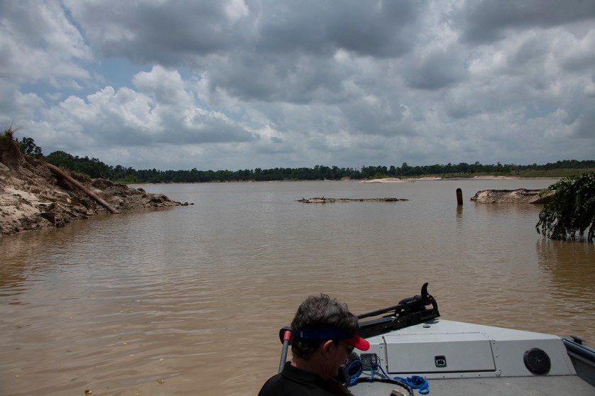
On its way to Lake Houston, your drinking water runs through a gauntlet of sand mines – some old, some new. Many discharge industrial process water directly into the San Jacinto River and its tributaries. The latest Google Earth LandSat images show a total of 11 between I-45 and US 59 on the West Fork doing just that. In addition, photos taken from a boat show another breach in a sand mine dike that happened more recently on Caney Creek, a tributary of the East Fork. Together, these images make a powerful case for moving mines out of the floodway and establishing best management practices for sand mines. The industry has fought both measures.
Dangers of Mining in Floodways
For miners in the Houston area, locating mines in floodways is a dangerous, but lucrative practice. Lucrative because there is less overburden for miners to move. Dangerous because rivers frequently sweep through mines during floods. The floods can then carry sediment downstream, which creates blockages that contribute to flooding.
Floods can also flush chloride-laden process water out of the mines and into your drinking water. That makes City of Houston water treatment costs more expensive. A former high level manager in the City’s water treatment department told me that he saw huge spikes in chlorides after every flood and tracked it to sand mines.
Pictures Aren’t Pretty
Massive breach in Triple-P mine on Caney Creek allows process water to mix with water in tributary for Lake Houston, source of drinking water for two million people.
After discovering the breach above, Josh Alberson whose boat we were in, spent an evening pouring over satellite images. Last week, he sent me a list of GPS coordinates to review additional suspected breaches or discharges. See the images below, all from the West Fork.
First mine north of confluence with Spring Creek.A local canoeist found three breaches in this mine last December.
Breach on right open since 2015.Breach on top left was closed after 2015. Harvey swept through all these mines in 2017.Note the stream at about two o’clock that is carrying sediment and process water to the river. Small pit in middle drains into West Fork.Overflow from mine contaminating West Fork.This pit has remained open for years at a time. Sometimes the water flows in, other times it flows out.Follow the stream from the pit on the right to the river on the left.It looks like someone actually installed two culverts and built a road over this breach.Note several small breaches in the bottom of this image and how the river is about to invade the major pit in the upper right,See the line of sediment in the clearcut area between the large green pond and the river. Discharges date back to 2006.West Fork San Jacinto just east of I-45.
Rule Rather than Exception
I could go on. But you get the idea. The TCEQ has said 15 sand mines are currently active on the West Fork between I-45 and US59. You just looked at a dozen breaches. Historical images in Google Earth show dozens of additional breaches in this same area. This is the rule rather than the exception.
Legislative Session Ends Hope for Improvement
Meanwhile, TACA, the Texas Aggregate and Concrete association, lobbied against establishing and publishing best practices for the industry including setbacks from rivers that could prevent this type of danger.
I drove up to Austin to speak for the bill. Rob Van Til, a sand miner representing TACA, spoke against it. Watch the testimony online at this link for the Committee Broadcast Archives. Make sure you scroll down to 5/1/19 and click on the link for Environmental Regulation. It lasts about 20 minutes. Here’s a guide for those short on time. At:
4:30 Huberty introduces the legislation to the committee.
6:45 Adrian Shelley, representing an environmental group, speaks for the bill.
8:45 Rob Van Til, representing TACA speaks against.
10:45 Representative Erin Zwiener questions Van Til
16.25 Bob Rehak speaks for HB 909
20:00 Huberty asks for committee support
The images above show why we need to move mines out of the floodway. But sadly, HB 909 never made it out of committee. The 86th Legislature ends this week. It’s time to start gearing up for 2021.
The thoughts expressed in this post represent my opinions on matters of public policy. They are protected by the First Amendment of the U.S. Constitution and the Anti-SLAPP statute of the Great State of Texas.
Posted by Bob Rehak on May 27, 2019 with help from Josh Alberson
636 Days after Hurricane Harvey
https://i0.wp.com/reduceflooding.com/wp-content/uploads/2019/05/ACEO.jpg?fit=1500%2C1069&ssl=110691500adminadmin2019-05-26 22:22:092019-05-27 04:22:31New Google Earth Image Shows Multiple West Fork Sand Mines Mixing Their Wastewater with Your Drinking Water
On the plans, LJA Engineers calls it S2 – the second detention pond in the southern portion of the new Woodridge development north of Elm Grove. Even though all drainage on the 268 clearcut acres slopes toward S2, the developer did not start building this crucial pond before the May 7 storm that flooded Elm Grove and North Kingwood Forest. The pond will ultimately hold 49.4 acre feet of water during a storm, but holds something less now because Rebel Contractors has not yet fully excavated it. Further, it appears that less than 10% of the site’s required detention was fully excavated when May storms struck.
Rebel Contractors Starts Expanding S2 After Flood
At the time of the May 7 flood, it appears that Rebel Contractors had not yet begun excavating the largest part of S2. I could see only a ditch connecting S1 with the large box culvert at the entry to Taylor Gully.
Photo taken on May 11, four days after Elm Grove Flood, shows extent of excavation for crucial S2 detention pond. Only this ditch connected S1 pond with Taylor Gully. Photo looks northeast, where giant pond should extend almost to tree line on both sides of image.
In the last seven days, however, Rebel has roughed out the pond. You can see it starting to assume its final shape, though it has not yet reached its final size or depth. See pictures below.
On Friday, May 24, I observed a steady parade of haulers moving earth from the future detention pond, S2. The contractor is using the excavated material to raise the height of streets and home pads elsewhere on the property in a process called “cut and fill.”
According to numerous residents that I have talked to, much of this area once consisted of wetlands. To develop such property, contractors use a process called “cut and fill.” They build up one area, by excavating another.
S2 pond in early stages of development. Plans show this should ultimately cover more than three acres and be 15 feet deep.Photo taken 5/25/19looking west from Taylor Gully toward Woodland Hills Drive.Plans for Woodridge Village show five detention ponds. Before the May 7 storm, it appears that only S1 was in place though even it was not finished. This raises the question, “Why did the developer focus on clearcutting the northern section before finishing crucial detention ponds on the southern section, where all the water from the north would flow?”
Only S1 Pond Fully Excavated at Time of Storm
Houston City Council Member Dave Martin investigating job site shortly after the May 7 flood on May 9. Shown here: The area that will become detention pond S1. It appeared to be the only semi-functioning detention pond on the entire 268 acres. This photo shows it almost fully excavated but not fully finished. Contractor will eventually slope right side to create more detention capacity and vegetate both sides to reduce erosion.
91% of Detention Capacity Not Completed at Time of Storm
Ultimately, the 268 acre site should hold five detention ponds with a total of 292.3 acre feet of storage. An acre foot would cover one acre to a depth of one foot. The bullet points below summarize the total storage of each pond in the map above.
N1 = 16.9 acre feet (not started)
N2 = 143.3 acre feet (started, but does not appear complete)
N3 = 56.4 acre feet (does not appear to be started)
S1 = 26.3 acre feet (mostly functioning, but not finished)
S2 = 49.4 acre feet (not exacted at time of May 7 storm)
Total = 292.3 acre feet
Not Started or Incomplete on May 7 = 91%
People in construction often use the term “substantially complete” to mean functional, but not fully finished.
Detention ponds collect runoff during a heavy rain. Then they release it at a slow, controlled rate that drainage ditches like Taylor Gully can handle without flooding people downstream. That’s the theory anyway. They do this by restricting the outflow compared to inflow. However, to function, they have to be BUILT.
How Much Rain Detention Ponds Should Have Held vs How Much Fell
Had all five ponds been complete on May 7, the entire site should have detained 1.1 feet of rain, a little more than 13 inches. However, we received less than 8 inches.
Jeff Lindner, the Harris County meteorologist, issued a statement on May 13 summarizing the storm that flooded Elm Grove and North Kingwood Forest. In it, he said, “A 30-min rate of 2.9 inches was recorded at US 59 and the West Fork of the San Jacinto River and a 1 hour rate of 4.0 inches. A 6-hr rainfall rate of 7.9 inches was recorded at the East Fork of the San Jacinto River and FM 1485. Rainfall rates between the 15-min and 6-hr time periods on Tuesday afternoon and evening averaged between a 2-yr and 50-yr frequency over the extreme northeast portions of Harris into southeast Montgomery Counties.”
Questions Owners and Contractors Need to Answer
In the last four years, we received three so-called 500-year storms. Two happened in the spring.
Knowing that, why did Rebel Contractors wait six months after clearing to begin excavating S2, the detention pond adjacent to areas that flooded?
Why did Rebel grade the rest of the site to funnel water toward Elm Grove before detention was in place?
Did economics factors push Rebel Contractors to clearcut the entire site before constructing detention that could control the runoff?
Why did Rebel Contractors fill in existing drainage features that could have helped reduce flooding before starting work on S2?
Why did Figure Four Partners claim that many of the detention ponds were complete?
If Figure Four improved drainage, why did homes flood that never flooded before?
Silt fences were supposed to be put up before any land was cleared. However, they were not put up until AFTER the flood on May 7. Why?
I hope I live long enough to learn the answers! I hope officials care enough to look for the answers! Tens of thousands of Kingwood homes did NOT flood during the May 7th storm; 196 homes next to this development did. They deserve answers.
All thoughts in this post are my opinions on matters of public policy and safety. They are protected by the First Amendment of the US Constitution and the Anti-SLAPP Statute of the Great State of Texas.
Posted by Bob Rehak on 5/26/2019
635 Days after Hurricane Harvey
https://i0.wp.com/reduceflooding.com/wp-content/uploads/2019/05/S2-Expansion_05.jpg?fit=1500%2C1000&ssl=110001500adminadmin2019-05-26 00:47:532019-05-27 04:18:48Key Woodridge Detention Pond Missing, Only Small Percent of Total Detention Developed Before Elm Grove Flooded
Tony Buzbee and Bill King both understand the importance of Kingwood in the upcoming Mayoral election. In the 2015 runoff, Sylvester Turner won by 4,000 votes city wide. But more than 28,000 registered voters in Kingwood didn’t vote, largely because of a major storm on Election Day. Storms may again shape this election, but in a different way.
Slow Pace of Mitigation Creates Opening
Since Hurricane Harvey, identifying the causes of flooding in the Kingwood area and mitigating them have dominated public discourse. Now both candidates running against incumbent Mayor Sylvester Turner are courting Kingwood residents. We could be the swing vote in the next election. And the slow pace of mitigation since Harvey could give them the opening they seek. Especially after recent flooding in Elm Grove reignited waves of anxiety.
King has met with many area residents on numerous occasions for the last year. He has slogged through swamps and sand dunes with me on more than one occasion, trying to see first hand how the San Jacinto became clogged with sediment, in part, due to sand mines in the floodway.
Buzbee joined the race later, but didn’t waste time wading into the issues. He asked local activists to arrange a trip to the mouth bar and a sand mine for him. When we got to the mouth bar, the former marine captain literally sprang out of the boat and waded ashore like he was taking a beach at Normandy.
Buzbee Sees Firsthand the Breach of Sand Mine Dike
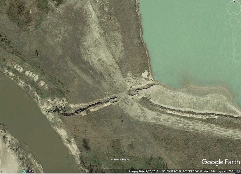
Upriver, at the sand mine, we saw a tangible example of a theoretical discussion I had been having with him for several months – a sand mine discharging silt and wastewater into the river. We discovered, by accident, a massive breach in the dike of the Triple-P mine in Porter.
As we turned a bend on Caney Creek, suddenly we realized we were no longer on the creek. We were in a channel that connected the creek to the Triple-P Mine in Porter.
About 50 to 100 feet of the dike had vanished. From the way trees laid down, it looked as though the wall of the mine had been blown outward by floodwaters.
Breach in dike. The tree laying down in the background at about a 10 degree angle is on Caney Creek which flows left to right in this shot.
Danger of Floodway Mining Comes to Life
Suddenly, all the tumblers clicked into place. Buzbee said, “So that’s what you’ve been talking about!” The danger of building mines in the floodway became apparent. It was what they call in science “The Aha Moment!” I could see him connecting thoughts that were previously unconnected, such as sand mine and mouth bar. He got it.
Luckily for Kingwood residents, a video crew was present when he got it. Here, on video, is Buzbee’s voyage of discovery.
While I have tried to keep flood discussions apolitical, inevitably the solutions are political. Hence, I am wading into some uncharted waters. I told Buzbee and King the same thing I will tell any candidate for any office. I will help you understand the causes of flooding in this area and what we need to mitigate them. My hope is that by making this part of the political debate, the candidates will focus awareness on the problems that leads to solutions.
I also make this promise to all candidates – incumbents and challengers alike. People deserve to hear what you have to say about flooding. Send me your thoughts or videos and I will publish them.
Posted by Bob Rehak on 5/24/2019 with special thanks to Josh Alberson and his boat
633 Days since Hurricane Harvey
https://i0.wp.com/reduceflooding.com/wp-content/uploads/2019/05/Buzbee.jpg?fit=1500%2C838&ssl=18381500adminadmin2019-05-24 20:58:242019-05-24 21:11:00Buzbee Video Puts Mouth Bar, Sand Mining at Center Stage In Mayoral Election
A review of construction plans for detention ponds and other site work in the troubled Woodridge Village subdivision revealed several deficiencies in the contractor’s performance to date. These deficiencies contributed to the widespread flooding on May 7 in Elm Grove and North Kingwood Forest. They have also affected life in those and other neighboring communities for months.
The plans submitted by LJA Engineers for Job #2027-1100L are dated July, 2018. Both the City of Houston and Montgomery County approved them. The plans specify responsibilities for Rebel Contractors.
Deficiencies include, but are not limited to, inadequate detention, poor drainage, missing silt fencing, not displaying permits, failure to repair damage to streets, and lack of supervision.
Missing Silt Fencing
Let’s start with a pretty standard one: silt fencing. Their purpose is to control runoff that carries silt into streets and sewers. The objective: avoid clogged storm drains that can exacerbate flooding and require expensive remediation.
The law requires contractors to erect silt fencing BEFORE they even clear the land. The contractor completed clearcutting the land adjacent to Elm Grove last November. But when I visited the job site on May 9 of this year – six months later – I could see no silt fencing…anywhere.
Image taken on 5/9/19 at north end of Village Springs Drive in Elm Grove. Note lack of silt fencing and presence of clay and silt in street.
Page 6, Point #5 says, “Contractor must inspect all structural controls at a minimum once every seven days and within 24 hours after a storm event that meets or exceeds .5 inches per 24 hour period.” Structural controls would include the silt fencing that wasn’t installed for 6 months.
Does it really make a difference? Look at the water quality in these two pictures taken by Jeff Miller in front of his home in Elm Grove.
Water in street in front of Jeff Miller’s house in Elm Grove during Harvey, BEFORE Rebel Contractors clearcut the area to the north.
Water in same street on May 7 after clearcutting adjacent area. No silt fences were installed.
Says Miller, the homeowner who took the pictures above, “Certainly in addition to suspended solids, there were also dissolved chemicals and biological materials (eg., diatoms) swept into Taylor Gully and our drinking water.” Miller is a retired project manager for a large pharmaceutical company and knows about the importance of avoiding contamination.
Missing or Inadequate Supervision
Several pages in the plans, including the cover page, specify that a professional engineer must monitor construction to ensure compliance with construction plans and specifications. If that person was doing his/her job, how could he/she possibly miss the lack of silt fencing…which is also specified on numerous pages? You should have to climb over it to get into the site!
Also on Page 2, Column 1, Point #5 states, “Adequate drainage shall be maintained at all times during construction and any drainage ditch or structure disturbed during construction shall be restored to existing conditions or better.” Again, the contractor filled in existing drainage, did not restore it, and Elm Grove flooded. The contractor also worked on the site for six months without installing the main detention pond in the area to where all water was draining. After the flood, it took them only a day or so to excavate most of the pond. Why wait so long?
Here’s where it should have gone.
Detention pond in red circle just above flooded homes was not in place before flood. Yet all the drainage for 268 acres exited the site through here. See photos below.
Image taken on 5/12/19, five days after storm by Bob Rehak shows detention pond S2 has not yet been excavated.
Page 2, Column 1, Point #8 states, “Any damage to any of the existing pavement and/or utilities must be repaired immediately. The contractor must notify the appropriate utility owner who will make the repairs at the contractor’s expense.” People in Porter have been complaining for months about how heavy construction traffic has crumbled their asphalt streets.
Heavy truck about to turn left into Webb Street construction entrance.Photo by Bob Rehak.
Page 2, Column 1, Point #15 states, “All pipe and reinforcement steel shall be kept free of dirt and other debris. Any damage to the coating of the various materials must be repaired.” See image below. Nuff said.
Taken from Woodland Hills Drive on May 8, 2019
Maintaining Adequate and Positive Drainage at All Times
It is also unlikely that the high water rescue vehicle below would have been necessary on May 7.
Houston Fire Department High Water Rescue Truck during May 7 flood in Elm Grove.
No Traffic Controls
Page 2, Column 4, Point #1 under Traffic Notes states, “Contractor shall provide and install traffic control devices in conformance with Part VI of the Texas Manual of Uniform Traffic Control Devices.” No traffic control devices are installed anywhere around the site as of this writing, yet construction machinery barges right out into traffic, as this equipment did in front of me. With one way in and out of this neighborhood, residents complain that they have had to wait up to half an hour while large equipment gets stuck in ditches.
Residents complain that equipment frequently blocks traffic. I witnessed this personally.
Page 6, Point #10 says, “Contractor is responsible for cleaning mud and or dirt tracked onto existing streets, by his workman’s, contractor’s or suppliers’ vehicles. Street must be cleared within 24 hours of when the tracking occurs.” Above, I caught the contractor dumping dirt on the street, in a feeble attempt to shore up the shoulder to widen the turning radius. The contractor succeeded only in further destroying the street. He should have widened his own driveway instead.
Complying with Environmental Laws
Page 6, Point #3 states, “Contractor will be responsible for complying with all environmental laws.” One such law stipulates that the contractor isn’t supposed to let silty water leave the site; hence the discussion of silt fences above. Another states that they must post their Stormwater Pollution Prevention Permits at site entrances. I looked high and low for those without success for the week after the flood. Then suddenly on May 16, I saw this posted.
Photographed on May 16, 2019, this should have been posted from the start of construction.
Such notices enable residents to file complaints when they notice violations. Not posting the notice makes it difficult to know where to complain or about whom to complain. If you have seen other suspicious activities you wish to report, here’s all about Stormwater Pollution Prevention Plans. They’re supposed to be monitored by the TCEQ.
Posted by Bob Rehak on 5/23/2019 with help from Jeff Miller, Gretchen Dunlap-Smith and Abel Vera
632 Days after Hurricane Harvey
https://i0.wp.com/reduceflooding.com/wp-content/uploads/2019/05/SWPPP.jpg?fit=1500%2C1000&ssl=110001500adminadmin2019-05-23 20:42:592019-07-09 18:22:47Contractor Not Executing All Requirements in Approved Woodridge Plans
During the afternoon and evening of May 7, 2019, the sky opened up and streets filled up. I counted one hundred and ninety-six homes in Elm Grove and North Kingwood Forest that flooded. This was by far the largest concentration anywhere in the Kingwood area. This is the story of one home among them.
I first met Keith Stewart online. He messaged me on FaceBook the night of May 3. He was offshore. His wife was panicking. He said, “A lot of flooding for the brief period of heavy rain in Elm Grove. Was almost as bad as Harvey on my block. What’s going on?”
“Something is Wrong!”
On May 7, he messaged me again. “Didn’t flood for 3 days of Harvey. Something is wrong…something has changed.” He sent this image that his wife had sent him.
Not even a black lab likes this kind of water.
This had to terrify Keith. His family was in danger and he was unable to help. He contacted me when he got onshore and we made arrangements to meet in person.
Stewart lives at the north end of Shady Maple Drive on the corner of Creek Manor. I interviewed him to get his impressions of why he flooded and where the water came from. Neighbors’ accounts confirm physical evidence.
The Wrong-Way Flood
Even though his lot backs up to Taylor Gulley, his home did not flood from there. Instead it flooded from the front. Water rushed down the street TOWARD the gulley and its force knocked over a street-facing fence anchored in concrete.
Stewart points to a broken fence post leaning toward Taylor Gulley in the background. The water came from the camera position and pushed the fence inward toward the gulley. Leaning fence posts show how the force of water from the front of the house (left) pushed the fence toward Taylor Gulley in the background (right). Camera is facing south.
As we talked, we stood on the east bank of Taylor Gulley looking toward the 260+ clear-cut acres to the north that comprise the soon-to-be Woodridge Village. We can see where constrictions in the flow of the gulley likely split runoff and forced it out of the creek.
The Woodridge Village area is in the background. Eyewitnesses, grass patterns, debris, and erosion suggest that these two outflow control devices, in the absence of detention ponds behind them which had yet to be built, split the runoff and diverted it into adjacent neighborhoods.
No More Wetlands
Rehak: Tell me what this property to the north looked like before it was clear cut.
Stewart: All that acreage that has been clearcut… When we moved here two years ago, I bought four wheelers for me and my son. That’s where we rode four wheelers. And no matter how dry, or how much of a drought, or how hot it was in the middle of the summers, back there, you could always find water. It was low. It was always swampy and stagnant water back there.
If we wanted to get wet and a little muddy, no matter how dry it was, we could ride the four wheelers back there.
Rehak: Now when you say back there, there are two sections: the northern and southern. Are you talking about one or both?
Stewart: There were four wheeler trails on both sides: the north AND the one closest to Elm Grove. But a lot of woods were torn down and there’s no standing water back there any more. So they’ve built everything up apparently. There are no swampy areas anymore.
Flood Did Not Come from Taylor Gully
Rehak: How high did the water in this ditch get relative to the top of the bank?
Stewart: I was offshore, but pictures show that it got to the top of the bank. I was comparing it to Harvey. My neighbors who have lived here for 30 years say the water has never even gotten Taylor Gulley three-quarters full. It was three-quarters full during Harvey at its peak…after three days of solid non-stop rain. My neighbor said that Taylor Gulley has never come close to overflowing in his experience. He said, “That’s not the direction water will come from if we get it.” He said, “It will come from a different direction.”
Never Flooded Before Despite Living Next to Taylor Gulley
Rehak: Was your wife home during the May 7 flood when you were offshore?
Stewart: She was at jury duty downtown. And when she got back to Kingwood, she had to pick up my high school kid. We had two dogs and two cats in the house. She thought, “As long as I can make it home, we’ll be OK. We don’t flood here. Never have. Never will … uh … until now. During Harvey, we watched it for three days and it never got close.”
Rehak: How are the dogs and cats?
Stewart: They’re physically OK, but a little distraught. We’re looking for a place to live and it’s hard to find someone that will take four animals. We don’t want to put them in kennels.
Rehak: Where are you living now? You mentioned something about going house to house. Staying with friends?
Stewart: Family members.
Rehak: What do you see as your future here? (Note: I’m thinking 5-10 years out. His answer surprises me. He’s still in shock and dealing with the crisis moment to moment.)
Stewart: I have ten days to see what I can get done here before I have to go back to work offshore. So I have to try to get everything set up for my family before I leave. And my high school kid is going through finals right now.
Rehak: Finals! What a rough ride for him!
Stewart: He’s in ROTC and his uniform got flooded. I just took that to the cleaners. But hopefully that will get straightened out for him.
Stewart worries about his insurance payout and has stacked damaged items he may be forced to salvage “if the numbers don’t work out.”
We walk toward his house from Taylor Gulley and I ask him about the furniture he has piled on his side deck. Pointing to the sinks and countertops, he says…
Stewart: We don’t know what the insurance numbers are going to be yet, so I’m keeping some damaged stuff in case we’re forced to salvage it.
What’s left of the Stewart living room.
Rehak: How much water did you get in the house?
Stewart: Nine inches. And the Friday rain before that … remember I messaged you and said somethings wrong … it came up higher than Harvey!
Remnants of a bedroom. Note how floor and walls on right are still wet.
The satellite image below shows the direction of flow described by Stewart. A neighbor told him the water flowed out of River Rose Drive and down Creek Manor toward his house. He did NOT flood from an overflow of the gulley.
As we were talking, two workers from City of Houston Public Works were checking street drains for blockages. They invited us to see what they saw on their camera. Mounted on the bottom of the pole, it sent a wireless image back up to the iPad that the woman was holding. Stewart is on the left.
The camera showed a trickle of water at the bottom of an otherwise clear drain. Conclusion: blocked drains did not cause the Stewart home to flood.Regardless of where the water came from, it could be weeks to months before Stewart’s home dries out enough to start replacing wallboard and insulation.
Crowdsourcing Some Detective Work
Stewart always thought that if he flooded, it would be from Taylor Gulley. But something changed. The flood came from the wrong direction. The same thing happened on the opposite side of the gulley. You can see Abel Vera’s home on Village Springs from Stewart’s back yard.
Did floodwater come from BEHIND the homes on Right Way and make its way down to River Rose? Please help fill in the gaps in our collective knowledge of this event. If you have any images or video that shed light on this subject one way or the other, please contact me through this web site. I will post the material and credit you.
Posted by Bob Rehak on 5/22/2019
631 Days since Hurricane Harvey
https://i0.wp.com/reduceflooding.com/wp-content/uploads/2019/05/Victim_23.jpg?fit=1500%2C1000&ssl=110001500adminadmin2019-05-22 22:22:112019-05-22 22:50:35The Wrong-Way Flood: Keith Stewart Interview
Home on Shady Maple in Elm Grove destroyed by flood on May 7.So where do you find help?
Harris County has opened a temporary Disaster Recovery Center in Kingwood at the United Methodist Church, 1799 Woodland Hills Drive, Room K105. Hours will be from 9 to 6 weekdays and 9 to 1 this coming Saturday. The Center will close for Memorial Day on May 27.
Flyer prepared by Harris CountyCommunity Services Department
“Resource Navigators” Will Help Flood Victims Find Help They Need
Early May flooding, while tragic, was not widespread enough to meet the requirements for a disaster declaration. So in the absence of a federal declaration, Harris County Community Services Department is referring individuals to multiple local resources – primarily churches and non-profits – that can provide assistance.
Harris County’s Community Services Department will use their Resource Navigators who handle similar requests on a daily basis.
Save Time While Seeking Help
Red Cross still remains the primary responder in the absence of a federal declaration. Community Services is only trying to assemble and refer to local providers who have capacity to assist. The county will hook you up with the people they’ve found through this Disaster Recovery Center.
Eligibility will depend on individual providers for specific requirements. But the Resource Navigators should be able to help you with those. Think of them as a way to save time while seeking help.
For More Information about Disaster Recovery Center
Call Harris County Community Services Department at 832-927-4955. Or email hrc@csd.hctx.net.
Posted by Bob Rehak on May 21, 2019
631 Days since Hurricane Harvey
https://i0.wp.com/reduceflooding.com/wp-content/uploads/2019/05/Victim_01.jpg?fit=1500%2C1000&ssl=110001500adminadmin2019-05-22 10:58:202019-05-22 11:01:15Harris County Opens Temporary Disaster Recovery Center In Kingwood to Help Recent Flood Victims
This is like the judge in a case hiring the defendant to render expert opinions for the plaintiffs. This story speaks to an overly cozy relationship between developers, engineers, contractors and regulators that can harm the citizens that government agencies are supposed to protect.
Bill King, a candidate for mayor of Houston, called this story “unbelievable.” “This kind of stuff has to stop,” he said.
Tony Buzbee, another mayoral candidate, also running on a reform platform, felt the same way. Buzbee said he was aware of no law that prohibited such conflicts in Texas. However, he felt this was highly unethical.
TCEQ Letter Provided Red Flag That Led to Discovery
After the flood on May 7th, I submitted a complaint to the TCEQ. It alleged that lack of detention in the Woodbridge development contributed to flooding in Elm Grove; that the site lacked silt fences; and that no berms existed to deflect floodwater from surrounding neighborhoods. I also pointed out that Stormwater Pollution Prevention Permits were NOT posted at the entrances to the job site. However, the TCEQ boiled all of that down to a one word complaint: flooding.
When I opened up their response today, my jaw dropped so far, so fast, it almost required a trip to the dentist. First, it referenced flooding on May 20, two weeks after the actual flooding, and four days AFTER they mailed their letter to me. But let’s assume that’s an innocent typo.
The big concern: TCEQ said my “request for assistance can be more appropriately handled through LJA Engineering FOR Montgomery County.” (Emphasis added.) Regular readers will remember that LJA Engineering developed the plans for Woodridge Village. Now they’re investigating what went wrong with the plans???
To clarify what the TCEQ meant by “FOR Montgomery County,” I called Nicole Morris at the TCEQ. A co-worker, Mr. Weston, called me back a short while later. He said that, “Yes, Montgomery County hired LJA Engineering to investigate these complaints.”
TCEQ Refers Me to Company that Engineered Site
The TCEQ letter also suggested I call LJA and referred me to a Mr. John Concienne. So I called him. The conversation lasted about 15 minutes. Headline: He works for their environmental division, not the one that developed the plans, and felt that excused the conflict.
Mr. Concienne seemed open about some things, but guarded about others. He repeatedly emphasized that he could only comment about what he saw on May 15. He also mischaracterized the nature of my complaint. Here’s how the conversation went.
Rehak: Mr. Concienne, my name is Bob Rehak. I’m calling in regard to the Elm Grove flooding that happened a couple weeks ago. I got a letter from the TCEQ that said you were handling complaints for Montgomery County. Is that true?
Concienne: Yes, sir. That is true.
Rehak: What exactly is LJA’s role for Montgomery County. Help me understand that.
Concienne: So, we are their stormwater consultant. We manage their permits.
Rehak: But weren’t you also the engineers on that Woodridge Village development?
Concienne: Yeah…so…well…I do believe that we did the design on that, but … um … but I’m not in the engineering group so I don’t have a ton of details on that. But yes, I do believe that we did the design work on that.
Rehak: Is that a conflict of interest?
Concienne: No. So we’ve dealt with that before. We have both an engineering side of our firm as well as an environmental side of our firm.
Rehak: OK… (Long pause)
Blaming Bad Execution
Concienne: So the way that’s laid out, we just do the design work, but we’re not the operators. We don’t have operational control of the site. Actually, my understanding is that there are two operators out there right now. I believe one of them is Rebel Contractors.
Rehak: Yes?
Concienne: And I believe that the other one is Figure Four Partners.
Rehak: OK.
Concienne: And so whenever we do an inspection on behalf of Montgomery County, we work directly with the operators who have acquired their permit from the county. That’s who we deal with. So…when we did that inspection out there, we actually submitted that to Revel Contractors who was onsite that day.
Initial Investigation Focuses on Silt, Not Flood Issues
Rehak: And what were your findings regarding the flooding? Can you tell me?
Concienne: Our inspector found three long stretches of the property that needed additional perimeter control. Along the southern perimeter from Woodland Hills Drive east to Friarwood Trail. That all needed perimeter controls put up.
Rehak: Do you mean silt fences?
Concienne: Yes, sir. Also along the drainage ditch running north to south along Needham Road to Taylor Gully. And also along the drainage ditch of the west side of the northernmost area adjacent to Webb Street. We found one surface inlet that was on their site that did not have controls around it. And then also there were two entrances and exits around the site that needed to be restabilized with bull rock. There’s one at Fair Grove Drive and one at Webb Street.
Couldn’t Remember Missing Detention
Rehak: What about detention on the property? Did you find anything unusual there?
Concienne: At the time of our inspection, they had a pretty sizable detention pond that they had put up. At the time of our inspection…now I can’t speak to what was present prior to that, but at the time of our inspection, they did have a rock berm inside the detention structure. And so…that was in place. (Note: They also installed that the day before the inspection.) Now the detention structure was not vegetated. It was all bare ground. So obviously…ideally…that would be vegetated, but it looked like it had just been developed. I would say it was a foot and a half to two feet tall inside of a wire material. And so it looks like that was in place. They did have a linear detention structure built on site.
5/15/19 photo by Jeff Miller shows rock berm placed in front of culvert just before LJA inspection.
Same culvert on 5/11, 4 Days after Elm Grove, shows that silt protection was not in place before inspection.
Rehak: What was the date of your inspection?
Concienne: May 15th.
Rehak: Did you see any detention north of Village Springs Drive? That’s the big detention area at the far eastern end of the proposed subdivision.
Concienne: I would have to go back and review my photographs of the inspection. But I don’t recall whether there were any other detention structures other than that one large linear structure that went into some concrete culverts and then discharged downstream. That’s the only one I remember seeing when I went through the photographs.
5/16/19 photo by Jeff Miller shows contractor excavating detention pond AFTER 5/15 inspection. But inspector claims he could not remember whether pond was there at time of inspection.
Rehak: There was supposed to be a huge pond attached to that.
Concienne: (Referring to the missing detention pond that was supposed to hold 43 acre feet of water.) I don’t recall seeing that in the photographs.
Remedial Action Started 36 Hours before First Inspection
Note: On the two days before LJA inspected the site, Rebel Contractors installed the rock berm and silt fencing along the southern border. Later, Concienne tells me that the silt fencing should have been up before any clearing even took place…almost seven months ago. Rebel Contractors still has not installed silt fencing everywhere they should.
Rehak: So you did an inspection on the 15th, and I can promise you that that detention wasn’t there on the 15th, but it is there now. It took them about a day to dig it. I’m wondering why it took them six months to put it in if it only took a day to do.
Concienne: Well, uh, yeah. Well, I’m not sure. I know there was obviously some flooding issues there around that area…
Rehak: That’s an understatement!
Concienne: That’s what kind of triggered all this. But on the stormwater quality end of it, like I said, we’re just looking at whatever’s present when we do our inspection. And so we document what was there the first time. And we document what has changed when we go there on Thursday. We requested some pretty extensive work. I know there are some long stretches of perimeter fencing so…there’s a chance that they may not have done it. I’m not sure.
LJA Explanation Conflicts with TCEQ
Rehak: So the complaint I lodged with the TCEQ had to do with flooding. And they referred me to you for answers on that. Now you’re telling me that you … don’t have anything to do with the flooding part???!!!
Concienne: Well, so, the construction general permit that that complaint was placed under with the TCEQ, is purely a stormwater quality permit. This does not involve quantity of water in any way. I know there’s certainly the possibility that silt left the site and potentially impacted things downstream…and we try to make that determination when we’re in the field…but for the most part that’s a stormwater quality permit and the TCEQ will tell you that they don’t deal with capacity at all. Now if there’s anything beyond that in terms of flooding, what degree there was, why the flooding occurred, that sort of thing, that’s a capacity issue, generally speaking.
Rehak: Who’s investigating that?
Doesn’t Know Who Is Investigating Flooding
Concienne: I’m not sure. I have a copy of the complaint from the TCEQ and like I said, this was a stormwater quality complaint that the TCEQ deals with. So um…any complaint that’s registered with the TCEQ is going to deal with quality, not quantity at all. (See how the TCEQ characterized the complaint as flooding!)
Rehak: So you don’t know if anyone is investigating the quantity part?
Concienne: You mean like why people flooded?
Rehak: Yes.
Concienne: Like I said, I wouldn’t make that determination. I’m not a hydrology guy at all.
Contractor Did Things Out of Order
One other thing struck me as odd: the timing of the erection of silt fencing on May 13 and 14.
Rehak: This site has been cleared for over 6 months and it didn’t have those silt detention things in place. Residents were complaining about mud in the streets for months. How long does it normally take after clearing before they should put the silt fences up?
No silt fences and mud in the street six months after contractor finished clearing site. Photo taken on 5/8.
Concienne: It’s supposed to be up before it’s cleared. The permit requires those controls are in place before any grading takes place. So those controls definitely should have been in place. We actually cited them on four different counts when we were out there. Now what the TCEQ will ultimately do with them? There’s a strong possibility they will get some type of enforcement.
Huge Questions Remain for LJA Engineering and Montgomery County
If LJA was responsible for permit compliance, why did LJA not inspect the site to make sure silt fencing was in place before grading began?
Why does LJA repeatedly emphasize that they can’t speak to what was on site before their inspection?
Why did Rebel Contractors suddenly start complying with permit requirements one day before the inspection? Were they tipped off?
Why did TCEQ refer me to LJA to answer flooding questions, when LJA denied it had any responsibility for flooding questions?
Why is one arm of LJA investigating a project that another arm designed?
Can LJA really provide an unbiased investigation of Figure Four Partners, the developer that hired it?
Knowing the potential for ethical conflict, why did Montgomery County not hire some other company for this particular investigation?
If LJA has a blanket contract to review all permit applications for Montgomery County, why does it not recuse itself from investigations involving itself and its clients?
At this hour, silt fences and bull rock still have not been installed everywhere they should be. Why?
Obviously, none of these parties (LJA Engineers, Figure Four Partners, and Rebel Contractors) are afraid of consequences from TCEQ or Montgomery County. The biggest question of all is “Why?” I talked to several Porter residents who complained bitterly to Montgomery County about the practices on this construction site. They said their calls to the County and the Sheriff’s Office fell on deaf ears. “It was like all the communication was going into a black hole,” one told me. That family sold its home and moved back to Harris County four months before the flood.
Gretchen Dunlap-Smith took the pictures below on 5/21/19, six days after the LJA inspection. They show the area near the Webb Street entrance in Porter where Rebel Contractors was ordered to install silt fending. Note the continued failure to meet requirements.
No silt fences to the left.
No silt fences to the right
Northwest corner of development.
Looking south toward Taylor Gully, no silt fences.
Webb Street Entrance. Still no bull rock that would allow trucks to enter without running across neighbor’s lawn.
Damage to neighbor’s lawn and public street because of inadequate entrance.
So many questions, so many compliance failures, so few consequences…with only a week before the start of hurricane season!
Posted by Bob Rehak on 5/21/2019 with photos from Gretchen Dunlap-Smith and Jeff Miller
630 Days since Hurricane Harvey
Thoughts expressed in this post represent my opinions on matters of public policy and safety. They are protected by the First Amendment of the U.S. Constitution and the Anti-SLAPP law of the Great State of Texas.
https://i0.wp.com/reduceflooding.com/wp-content/uploads/2019/05/51siltfence052119.jpg?fit=1080%2C810&ssl=18101080adminadmin2019-05-21 23:23:302019-05-22 07:14:03Elm Grove Update: Montgomery County Hired Company that Designed Woodridge to Investigate Woodridge Permit Violations
Hundreds of residents in Elm Grove and North Kingwood Forest, south of the new Woodridge Village development, flooded last week. Everyone says they never flooded before the contractor started clearcutting and grading the property. So what changed? Clearcutting removed all the plants and ponds that slowed the water’s velocity. It also exposed a highly impervious clay soil base, so slick when wet, that it offered very little resistance to flow. That accelerated stormwaters toward Elm Grove, where detention ponds had yet to be built and, according to residents, the developer had filled in natural drainage features.
Geologist Finds Impervious Clay
I asked a retired top geologist from one of the world’s largest oil companies to describe the soil composition. The answer? At least 50% clay. “Because clay grains are very small (<2 microns), plate shaped and tightly bonded, water does not easily or quickly move through or into clay-dominant sediments without the help of plant roots.” Thus, there’s much more runoff than absorption, especially after clearcutting and grading.
To check that assumption, he dug a hole and filled it with water from a bucket.
The water took 15 minutes to go down one-half inch.
Absorption rate indicates low permeabilityand high runoff rates.Note the ponding water halfway up the stake, still sitting on the surface from week-old rains.
Still Had Standing Water Eight Days after Rain
He continued. “The presence of many puddles of standing water from week-old rains indicate that clay-dominant sediment like I sampled is wide spread across the site as it is throughout our fluvial flood plain setting – except locally where sandy channel fills are also present.”
Standing water remained on the site, days after the last rain, indicating a high clay content.
What a Photo Can Tell: Decoding Erosion Patterns
I also asked him to analyze this photo below and tell me whether it changed his opinion of soil composition. The photo was taken directly north of the box culvert installed by the developer near Taylor Gulley. The area was several blocks from where he sampled soil.
Several days after this photo was taken the contractor excavated this area to form a retention pond that should have been there before the flood.
When the geologist saw the photo above, he said:
The erosion itself indicates a high rate of water runoff and minimal absorption.
Steep edges imply cohesion typically associated with clay. Sand or less cohesive soils would slump.
Standing water proves low percolation rate. Only clay rich sediments would hold water like that for more than a few hours.
What Contractor Should Have Known
The contractor developing the site had to know the soil was impervious. They had worked it for a year or more and had to see standing water on numerous occasions that reportedly caused delays. Still, they did several things that increased flood risk for downstream residents – before they completed site detention. For instance, they:
Basically, they increased the slope of land, reduced the friction that vegetation provides, and accelerated runoff toward an area that they knew could flood, across soil that they knew was impervious…before finishing the detention work.
Photo by Jeff Miller on 5/16/2019, more than a week after the Elm Grove flood, shows developer starting to excavate the detention pond near the portion of Elm Grove and North Kingwood Forest that Flooded.
Had all the detention been installed before the storm hit, Elm Grove and surrounding areas should not have flooded.
Hydrologist’s Claims at Odds with Performance
The hydrologist’s conclusion (see page 3 of the 59 page report) states that on-site detention should hold up to a hundred-year rain. But the Harris County meteorologist estimates that on the day Elm Grove flooded, the area received at most a 50-year rain. Maybe everything wasn’t working as planned after all. Maybe the developer should have changed its approach too construction. Developing detention sooner could have reduced flood risk.
Posted by Bob Rehak with help from Jeff Miller on 5/20/2019
629 Days since Hurricane Harvey
https://i0.wp.com/reduceflooding.com/wp-content/uploads/2019/05/20190518_135415.jpeg?fit=622%2C1280&ssl=11280622adminadmin2019-05-20 21:34:252019-05-20 21:34:51Impervious Clay in Clear-Cut Area Accelerated Runoff Toward Elm Grove Before Detention Fully Developed