The second district makes an arc around the north and west sides of Houston. So expect the discussion to cover more than just the Lake Houston area. Likely topics will include (but by no means are limited to):
Additional flood gates for Lake Houston
Addicks Reservoir
Houston Ship Channel
White Oak Bayou
Other local projects with shared Federal funding.
Attendees can ask questions online. Organizers have committed most of the time to answering those questions. The discussion should last 45 minutes, and in no case will exceed an hour.
https://i0.wp.com/reduceflooding.com/wp-content/uploads/2020/05/Crenshaw-Webinar.jpeg?fit=1200%2C1200&ssl=112001200adminadmin2020-05-19 13:22:432020-05-19 13:22:55“Coffee Break with Dan Crenshaw” Will Discuss Flood Projects in Second Congressional District
Through a Freedom of Information Act (FOIA) request, ReduceFlooding.com has obtained details of Harris County’s request to the City of Houston to revise its flood regs. Complying with the request is one of two conditions the City must meet before the County will purchase Perry Homes’ Woodridge Village.
First, the County wanted the cash-poor City to pay for half the purchase through the donation of land that the County could then use to help offset costs for other HCFCD projects.
Second, the County wanted the City update to its stormwater and floodplain ordinances to make them consistent with the County’s.
Harmonizing the regulations would provide consistency between the three largest governmental agencies tasked with drainage projects in the our area: Harris County Engineering Department, Harris County Flood Control, and the City of Houston.
This is the first step in getting all municipalities and County governments that drain to Harris County to adopt similar standards to help reduce flooding risks and protect the billions of dollars of drainage infrastructure investments currently being made in the area.
A Houston Chronicle article (that didn’t even mention Elm Grove) said, that in the future, the county would not share flood bond money with any of 34 different municipalities within its jurisdiction that have not updated and harmonized their regulations with Harris County’s.
So what were the requested changes?
Below are revisions needed for the City of Houston to comply with Harris County Infrastructure Regulations (2019 version) and the HCFCD Policy, Criteria and Procedures Manual.
In all cases cited below, Harris County flood regulations exceed the City of Houston’s. The County does not ask the City to relax any guidelines.
Houston Chapter 9 (Stormwater Design Requirements – July 2019)
General Note – The City updated this Chapter in late 2019 to add Atlas 14 rainfall information for use in storm sewer design. The County also added Atlas 14 to its regulations.
However, the County requests that the City make additional changes as follows:
Section 9.2 Design Requirements:
9.2.01(B)(3)(a)(1) Table of Rational Method Runoff Coefficients – Must be updated for lots greater than ¼ acre to be consistent with Harris County requirements.
9.2.01(C)(7)(d) Table 9-2 – Revise inlet capacities for Type A, D, D-1, C-2, C-2A, D, D-1, and E inlets to be consistent with Harris County requirements.
9.2.01(D)(3)(c) Relationship of Structures to Street – Revise finished slab elevation criteria to be consistent with Harris County requirements of 18” above the 100-year floodplain, one foot above the maximum ponding depth within a 10’ radius of the structure or at or above the 500-year floodplain, whichever is higher.
9.2.01(H)(2)(d) Waiver of Detention Requirements – Remove this section; it would allow developments to be constructed without detention.
9.2.01(H)(3)(a-e) Calculation of Detention Volume – Revise to remove detention rates based on tract size, revise detention rates to be consistent with Harris County requirements of 0.75 acre-feet/acre for storm sewer outfalls and 1.0 acre-feet/acre for roadside ditch outfalls, or HCFCD requirements if outfalling to HCFCD facility.
9.2.01(H)(3)(a-e) Tracts >50 acres – Refer to HCFCD requirements if outfalling to HCFCD facility, otherwise refer to Harris County requirements if outfalling to storm sewer or roadside ditch.
9.2.01(H)(4) Calculation of Outlet Size – Revise to be consistent with Harris County requirements, remove minimum restrictor size, remove allowable discharge rates of 0.5 cfs and 2.0 cfs per acre and include calculated allowable rates.
9.2.01(H)(5)(a) Private Facilities – Include Harris County pumped detention information including detention rate, allowable drain times, and percentage that must be drained by gravity. Add minimum bottom slopes and pilot channel slopes from Harris County requirements.
Houston Code of Ordinances, Chapter 19 Floodplain (September 2018)
Under Article III: Standards for Flood Hazard Reduction:
19-33(a) Base Flood Elevation Requirements –Must also include a provision that no fill will be allowed to elevate structures proposed for the 100-year floodplain. These structures must be on open foundations designed by a structural engineer.
19-33(c) AO Zones –Revise to require finish floor elevation of three feet above the depth number noted in the specific zone, or 6 feet if no depth number is specified.
19-34(a)(4) –Remove this item that allows fill to be placed in the 0.2% floodplain without mitigating excavation.
19-34(d) Critical Facilities –Add requirement for these facilities to have the lowest floor elevated 24” above the crown of the adjacent street if that is higher than 3’ above the 0.2% elevation.
19-43 (c)&(d) Floodways – Require an engineering report for the foundation in addition to the “no-rise” analysis and mitigation requirements. Add Harris County requirements for foundation design.
19-43(e) Bridges – Add requirement that all bridge construction that modifies the base flood elevation or that modifies the geometry of the bridge or channel must submit a CLOMR and LOMR.
19-75 Manufactured home placement in a floodway or coastal high hazard area – Remove this section that allows for manufactured homes to be placed in these areas.
The County also recommends that the Harris County Floodplain Administratorshould reviewChapter 19 for additional changes to ensure consistency with Harris County floodplain regulations.
Negotiations Still Reportedly Ongoing
City of Houston did not discuss conditions of the Perry purchase in last week’s City Council session. Neither are County Commissioners scheduled to discuss them this week. However, negotiations with Perry are reportedly continuing despite the passage of Perry’s extended deadline.
Meanwhile, with hurricane season less than two weeks away, Perry Homes’ new contractors continue to put the full-court press on construction of detention ponds. They have made more progress in two months than the previous contractors did in two years.
Posted by Bob Rehak on 5/19/2020with keyframe from Jim Zura, Zura Productions
994 Days after Hurricane Harvey and 243 after Imelda
https://i0.wp.com/reduceflooding.com/wp-content/uploads/2019/05/NotWetlands.jpg?fit=1500%2C835&ssl=18351500adminadmin2020-05-19 11:03:122020-05-19 13:06:30Flood Regs: What County Wants City to Do as Part of Woodridge Village Purchase Deal
The northern section of Perry Homes’ Woodridge Village now has three detention ponds in various stages of completion. As of a week ago, on May 11, 2020, all three were capable of holding water and did during last weekend’s rains. That meant much rainfall that previously might have overwhelmed the two southern detention ponds had places to hold up instead of overflowing into Elm Grove and flooding residents.
No Record Rainfall, But No Flooding Either
Harris County’s Flood Warning System shows that the area received about two and a half inches of rain last weekend. A 2.5 inch rain is far from a record. But forecasters predicted much more. And some areas to the south and east of Lake Houston got more than 10 inches! So Elm Grove residents lucked out, but they were rightly worried.
In the end, whether it was the additional detention capacity or the lighter rain, no one flooded. And that’s what counts.
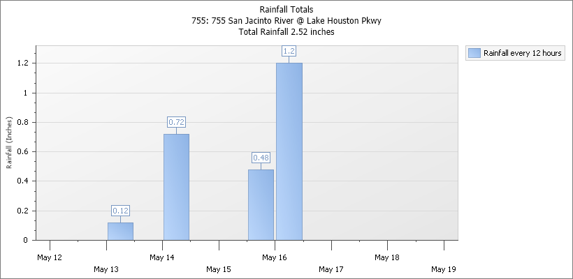
The Harris County Flood Warning System shows that the nearest official rain gage to Elm Grove is at West Lake Houston Parkway. It registered 2.52 inches of rain in 3 DAYS. 2.52 inches would have to fall in 3 HOURS to even make this chart, and then it would be something we could expect every year.Source: NOAA
Status of Detention Pond Construction
So what is the current status of construction? As of last Monday, the two ponds on the southern section (S1 and S2) were complete.
Of the three ponds on the northern section:
N1 was partially excavated, with most of the capacity in the “tail” leading south toward N2.
N2 was about 80% excavated. Workers were expanding the new section and deepening the old section, developed by Montgomery County many years ago.
N3 was approximately half complete.
Part of N1 Excavation as of May 11, 2020Massive N2 pond in southwest corner of northern section. Grassy portion was previously excavated by MoCo, but contractors are deepening it. Photo taken May 11, 2020.Looking south at Woodridge Village N3 detention pond photo from week ago, May 11, 2020.Elm Grove is out of sight beyond top of frame.
As last week wore on, each pond expanded compared to the three images you see above. Jeff Miller, an Elm Grove resident who lives near Woodridge Village, estimates that all three detention ponds on the northern section were about 80% excavated by the end of last week. However, he also noted that much work remains in terms of sloping the sides, stabilizing soil, building pilot channels and connecting ponds.
Barring further major rains and at the current rate, Miller estimates contractors could finish all three ponds in June.
How They Performed Last Weekend
N1
The first shot below shows the tail of N1. It was not yet connected to N2 so water could not drain out of it.
Photo of N1, looking north, by Jeff Miller on Saturday after rains stopped.
N2
I have no pictures showing how well N2 did at holding back rain, but neither Taylor Gully nor the southern detention ponds overflowed.
N3
Prior to the rain, this portion of N3 was deep enough to conceal all but the top of a large dump truck.N3 might have held approximately 5 feet of water according to Miller.
Additional Culverts for Connecting N1 and N3
Jeff Miller also photographed these 4×4 box culverts stacked up north of N3.
Note the concrete box culverts stacked up north of N3. Plans call for connecting N1 and N2 with such culverts.Also notice how land has been sloped from left to right to flow into N3.See water draining into N3 from a temporary ditch that cuts through the bottom of the image.
Layout and Capacity of All Ditches
Layout of detention ponds on Perry Homes’ Woodridge Village.This pie chart shows the relative capacity of Woodridge Village detention ponds. In the May flood last year, only the blue pond was complete. By the September flood, Perry had also completed the green pond. The three northern detention ponds hold 77% of planned storage capacity. None of those had even started.
Conclusion
Last week’s rains were a small test. But results showed the work already done has added to to detention capacity.
Miller says that water from the northern section did not appear to spill over into S2. His pictures also showed that S2 was only half full.
That meant the entire rain, with the help of new detention ponds, was able to drain out through a 3 foot corrugated pipe that connects Taylor Gully on either side of the county line, just like it used to.
This is welcome news for flood-weary Elm Grove and North Kingwood Forest residents who feared the worst.
No Progress to Report on the Political or Purchase Fronts
Even though the deadline for a Harris County purchase of Woodridge Village from Perry has passed, and even though Commissioners are not supposed to discuss the buyout in tomorrow’s Commissioner’s Court meeting, Precinct 4 Commissioner Jack Cagle says negotiations are ongoing.
The County made an offer to buy the land in order to build a regional flood detention facility. But the offer was contingent on the City of Houston donating $7 million worth of other property to the Flood Control District to help offset costs. The City also had to adopt County drainage criteria. It reportedly is more conservative than current City standards.
Posted by Bob Rehak on 5/18/2020 with photos and reporting from Jeff Miller
993 days since Hurricane Harvey and 242 since Imelda
The thoughts expressed in this post represent opinions on matters of public concern and safety. They are protected by the First Amendment of the US Constitution and the Anti-SLAPP Statute of the Great State of Texas.
https://i0.wp.com/reduceflooding.com/wp-content/uploads/2020/05/20200516-IMG_1440.jpg?fit=1200%2C900&ssl=19001200adminadmin2020-05-18 17:53:562020-05-18 18:23:32New Perry Detention Ponds Held Surprising Amount of Rain Last Weekend
Erosion can sometimes be sudden. It’s not always a slow process of water grinding away at dirt and dissolving it, or wearing down rocks. This post will examine several examples around us and look at their implications. I intend it as a continuation of yesterday’s post about ditch maintenance.
The Northpark Woods development (right) on the West Fork San Jacinto River (background)
Hydraulic action – When rapidly moving water churns against river banks and scours or undermines them.
Abrasion – Caused by small pebbles moving along a river bank or bed and knocking other particles loose. Think of sandpaper.
Attrition – When rocks carried by the river knock against each other. They break apart to become smaller and more rounded. This is how boulders turn into gravel.
Solution – When water dissolves certain types of rocks, for example limestone. We often see this in Florida, where sinkholes frequently develop.
Most of these processes happen slowly. But the first can be sudden. One storm. One flood. And boom. That river bank where you used to sit and quietly contemplate nature is gone.
Now You See It; Now You Don’t
Sometimes large slabs of a river bank or ditch suddenly slump into a river, almost like mini landslides. One flood expert commented on the picture above; he said “The owners of those new homes may suddenly find the ditch in their backyards.”
At other times, the size of a flood forces a river to widen. We saw this during Harvey and Imelda. The relentless pounding of flood waters carries away everything in their path. Cutbanks (the outside of a river bend) are especially vulnerable. Water slams directly into them like a firehose and washes them away. This action actually changes the course of a river over time.
Most of the time, it happens so slowly, we barely notice it. But during large floods, it’s sometimes sudden, large, and devastating to homeowners or businesses near rivers.
Three More Examples of Hydraulic Action
Example A: East End Park
East End Park in Kingwood. In 2019, the San Jacinto East Fork removed approximately 50-100 feet of river bank during Imelda,including this part of the Overlook Trail.
Example B: Balcom House and River Migration
Note a long peninsula south of the Balcom House on the San Jacinto West Fork before Hurricane Harvey.After one monster storm, the peninsula was gone. The Balcoms lost 175 feet of riverfront property.
Example C: River Aggregate Mine on West Fork in Porter
The third example comes from the abandoned River Aggregates sand mine beyond the new development in the first picture above. It’s a spectacular example of river migration.
In this case, the San Jacinto West Fork migrated 258 feet toward the mine’s dike in 23 years. When I first photographed the dike after Harvey, the river had eaten away an average of 12.4 feet per year. At the time, the dike was only 38 feet wide, and I predicted it could soon fail. It did. Within approximately a year.
Image taken on 9/14/2017, shortly after Hurricane Harvey. At the time, only 38 feet stood between the abandoned mine in the background that the San Jacinto west fork in the foreground.Note how the pond in the foreground disappeared when the river took the last 38 feet of river bank.
Wait a minute, you say! What happened to the pond. After the river bank collapsed, the pond drained, exposing sediment already within it. And the action of draining concentrated more sediment in it, like all the remnants of food trapped in your sink drain after you’re done washing dishes.
History of Pond
The missing, shallow pond in the foreground above used to be the settling pond for River Aggregates.
This satellite image from 2004 shows thatRiver Aggregates used the missing pond as a settling pond.This is how the mine looked in 2017 after River Aggregates abandoned it.Note river bank is still intact.This is how the abandoned mine looked in January of 2019. The river bank was gone. The pond had drained. And a steady stream of silty water from other ponds leaked into the West Fork.
Here’s how it looks today from a helicopter.
River Aggregates mine now leaks a steady stream of silty water into the West Fork San Jacinto.This is the same area as above, but from the reverse angle.
Lessons of Life Near a River
Most people never live long enough to see massive changes such as these in rivers. In most places, river change happens on a geologic time scale. But along the Gulf Coast, hurricanes can create floods that make rivers change on a human time scale, as these examples have shown.
What can we deduce from this?
Around here, we need to give rivers room to roam. Parks, green spaces, and golf courses, often represent the highest and best use of land near a river, bayou or ditch.
Building too close to rivers, bayous and drainage ditches can be costly. Disturbing wetlands and topsoil accelerates erosion. That, in turn, can threaten everything in its path. Be prepared to maintain anything you build near a watercourse, including the watercourse itself. And be prepared to fight what ultimately becomes a losing battle.
The thoughts expressed in this post represent opinions on matters of public concern and safety. They are protected by the First Amendment of the US Constitution and the Anti-SLAPP Statute of the Great State of Texas.
https://i0.wp.com/reduceflooding.com/wp-content/uploads/2019/10/EastForkByBoat_115.jpg?fit=1280%2C854&ssl=18541280adminadmin2020-05-18 09:09:122020-05-18 09:39:26Erosion: Sometimes Sudden
Harris County Flood Control District has quietly started repairs to two more Kingwood Drainage Ditches. The first is G103-33-01, the ditch between Fosters Mill and Kings Point that enters the river near the mouth bar at Scenic Shores. The second is the Kingwood Diversion Ditch, G-103-38-00. It runs down the west side of Woodland Hills, crosses Kingwood Drive by the fire station, then descends to the lake between Trailwood Village and Forest Cove.
Work In Progress as of Monday 5/11/2020
Erosion on the ditch between Fosters Mill and Kings Point that enters Lake Houston near the mouth bar (background) undergoes repair.Turbulence downstream of weirs, bottom left, commonly results in erosion.Here’s what the erosion looked like before repairs started. Picture taken in 2018 courtesy of HCFCD.Close up of eroded drain pipe near weir.
Work on Diversion Ditch Expected to Start This Week
According to Beth Walters of Harris County Flood Control, work on the Diversion Ditch should start this week. Below are several pictures taken of severe erosion that threatens homes and trails.
Looking west at Property in Deer Ridge Estates threatened by erosion of Kingwood Diversion Ditch. Looking west. Picture taken Jan. 2019.Looking south at the Kingwood Diversion Ditch erosion just south of Walnut Lane. This area is a perennial problem. Photo taken in 2009.Kayakers have dubbed this area the Kingwood rapids. During floods, it offers the only white water experience in Kingwood.
Ditch maintenance includes erosion repairs, silt buildup removal, mowing, de-snagging (removing downed trees), and removing collapsed drainpipes.
Erosion in Kingwood Diversion Ditch near fire station on Kingwood Drive.
Additional details are not yet available on the length of time repairs will take.
Thursday evening, I posted about a drainage ditch on the western edge of Woodridge Village in Montgomery County that Perry contractors had partially blocked off.
Encroachment on Adams Oaks drainage ditch by Perry Homes Contractors in Woodridge Village. Note how dirt spills past silt fence still visible in upper right.Picture taken on Monday, 5/11//2020.
With storms and possible flash flooding predicted for Friday and Saturday, nervous residents worried about possibly flooding a third time and expressed their concerns to the contractor. Luckily, the current batch of Perry Homes’ contractors proved far more responsive than the last.
Contractors Clean Out Ditch Friday Morning Before Storm
Friday morning, they started cleaning out and widening the ditch. The rains came that night and into Saturday morning. And the nervous residents breathed a sigh of relief. There was no visible flooding, according to Jeff Miller, who toured Adams Oaks Saturday morning as rain ended.
Miller sent in these pictures of work in progress on Friday morning before the rain.
Looking north. Adams Oaks resident inspects widening in progress on Friday morning. Photo by Jeff Miller taken 5/15/2020.Reverse angle looking south toward N2 detention pond and Kingwood.Photo by Jeff Miller taken 5/15/2020.
Miller’s pictures make it apparent that the ditch which emptied Adams Oaks is becoming part of a much bigger ditch that extends south from Detention Pond N2. In fact, the old ditch looks as though it will become the backslope interceptor swale for the new, bigger ditch, which is really the tail of the N1 detention pond that helps connect it to N2 and Taylor Gully. See map and photo below.
The newly “rehabilitated” ditch ran along the western (left) edge of Woodridge Village between N1 and N2.
Photo by Jeff Miller taken Saturday morning, shows that the old ditch, left, became the backslope interceptor swale for a much bigger new ditch (right.) This should improve Adams Oaks drainage. Photo take Saturday, 5/16/2020 after about 2 inches of rain.
Regardless, the contractors responded to concerns and scrambled to connect Adams Oaks with their drainage system before the storm.
Standing at the end of Flower Ridge in Adams Oaks and looking west toward Woodridge Village.Photo by Jeff Miller taken Saturday, 5/16/2020.
Further south, you can see east/west drainage from Mace and Joseph reaching north/south drainage on Woodridge.Photo by Jeff Miller taken 5/16/2020.
As additional detention ponds take shape, they will help hold water back from S1 and S2. That may help them prevent overflowing which flooded Elm Grove twice last year.
Status of Sale to County/City
That’s important. By Houston law, any financial transaction greater than $50,000 must be approved by a vote of City Council. And the Council did not consider the donation of land to Harris County Flood Control this week for a Perry deal this week.
You may remember that that was one of two conditions Harris County put on a purchase deal with Perry Homes. And Friday was Perry Homes’ deadline for consummating a deal. However, if the City and County can work something out before Perry finds a private buyer, I assume the land would still be for sale.
Posted by Bob Rehak on 5/16/2020 with photos and reporting by Jeff Miller.
991 Days since Hurricane Harvey
The thoughts expressed in this post represent opinions on matters of public concern and safety. They are protected by the First Amendment of the US Constitution and the Anti-SLAPP Statute of the Great State of Texas.
https://i0.wp.com/reduceflooding.com/wp-content/uploads/2020/05/IMG_1424.jpg?fit=640%2C480&ssl=1480640adminadmin2020-05-16 15:47:172020-05-16 16:02:27Perry Contractors Opened Up Woodridge Ditch Hours Before Rain Struck
Aerial photos taken on 5/11/2020 show wastewater on neighboring properties outside the Triple PG mine in Porter are higher than in the mine’s settling pond. If heavy rains materialize this weekend as predicted, that wastewater could be flushed downstream into the drinking water for 2 million people.
Mine Has History of Dumping and Pumping
Earlier this year, I photographed the mine pumping wastewater from its settling pond toward the neighboring properties. A TCEQ investigation confirmed that wastewater had exited the mine for the fourth time in a year. Investigators found that the wastewater had levels of suspended solids 676% higher than water from nearby White Oak Creek. But they also found that elevation differences had confined the wastewater and kept it from entering the wetlands near White Oak Creek.
Heavy Rains, Flash Flooding Could Flush Water Downstream
However, heavy rains predicted for later today and Saturday could change that. Jeff Lindner, Harris County Flood Control meteorologist says rainfall rates of 1-3 inches per hour will be possible and there is a slight (10-20%) risk of flash flooding, both days. Isolated totals could reach 6 inches on Saturday, he predicts.
How High Is Water On Neighboring Properties
So how high is the water outside the mine compared to inside?
In the photo below, note the two sets of arrows on either side of the road. The strip of trees under the upper right arrow does not belong to the mine. However, the land under the lower right arrow does belong to the mine. I included the second set of arrows because they are closer to the camera and that makes it easier to see the elevation difference in the water. Notice how much higher the water is on the right than on the left relative to the road.
Looking south at Triple PG mine in Porter. Photo taken 5/11/2020.Looking east over flooded properties (inside tree-line) that neighbor mine.Photo taken 5/11/2020.Terms of a temporary injunction restrict the mine from using its dredge. So the mine has started dry (or semi-dry) excavation. That meant removing wastewater from this pit.Photo taken 5/11/2020.
On January 20, 2020, I photographed the mine pumping water out of its settling pond toward adjoining properties. See below. The pit above can be seen in the upper left of the photo below.
See the pipe cutting diagonally from the middle of the frame to the lower right. Also note, the pond in the upper left of this image corresponds to the pond in the foreground of the image below.Note water level on January 20, 2020By February 13, three weeks later, that pond was largely empty. It is common for mines to pump water from one pond to another.But illegal to pump water outside the mine.
Why Mines Should Not Flaunt Rules
If approaching storms flush sediment- and chloride-laden wastewater downstream, it will end up in the San Jacinto East Fork and Lake Houston, the source of drinking water for 2 million people.
This underscores the need for the state legislature to pass laws that move mines out of the floodway. The Triple PG mine actually sits at the confluence of two floodways. That makes it vulnerable and dangerous…especially when an operator apparently flaunts rules designed to protect the safety of the public.
Posted by Bob Rehak on 5/15/2020
990 Days after Hurricane Harvey and 239 since Imelda
The thoughts expressed in this post represent opinions on matters of public concern and safety. They are protected by the First Amendment of the US Constitution and the Anti-SLAPP Statute of the Great State of Texas.
https://i0.wp.com/reduceflooding.com/wp-content/uploads/2020/05/20200511-RJR_2662.jpg?fit=1200%2C800&ssl=18001200adminadmin2020-05-15 09:49:002020-05-15 11:02:10As Heavy Rains Approach, Triple PG Wastewater Higher on Neighboring Properties Than In Its Settling Pond
Aerial photos taken Monday this week (5/11/2020) show that Perry Homes’ contractors appear to be partially blocking drainage that serves dozens of homes on the western side of Woodridge Village in Porter. With heavy rain expected this weekend, residents like Gretchen Dunlap Smith are nervous.
Homes Flooded Twice Last Year by Water that Could Not Get Out of Neighborhood
Many of those homes flooded twice last year, in May and September, just as homes in Elm Grove did.
Looking south toward Kingwood along the western edge of Woodridge Village in Montgomery County.
The issue with these homes, however, was that water could not get out of the neighborhood because of altered drainage.
Water drains to the east (left) into the drainage ditch along the perimeter of Woodridge, and then south toward the top of the photo to Taylor Gully.
This enlargement, cropped from the photo above, shows how the perimeter road is pushing into the drainage ditch for homes in the older Adams Oaks subdivision to the right.
Hovering over Flower Ridge in Porter and looking southeast. Note how workers have pushed past Perry’s own silt fence (upper right) that marked the old edge of the ditch and how dirt from construction is now collapsing into the ditch.
Jeff Lindner, Harris County meteorologist said this afternoon, “Expect a line or complex of slow-moving thunderstorms to move across SE TX Saturday starting out west in the morning and spreading across the area throughout the day. There will be a low severe threat with this activity, but the main threat will be heavy rainfall.
As of Thursday, NOAA and the National Weather Service predict heavy rains and possible flash flooding across all of SE Texas.
That gives contractors one day, Friday, to clean out that ditch to avoid another possible flood and more possible lawsuits.
Posted by Bob Rehak on 5/14/2020
989 Days since Hurricane Harvey and 238 since Imelda
The thoughts expressed in this post represent opinions on matters of public concern and safety. They are protected by the First Amendment of the US Constitution and the Anti-SLAPP Statute of the Great State of Texas.
https://i0.wp.com/reduceflooding.com/wp-content/uploads/2020/05/20200511-RJR_2893.jpg?fit=1200%2C1036&ssl=110361200adminadmin2020-05-14 21:14:322020-05-14 21:14:44Perry Contractors Encroaching on Porter Drainage Ditch West of Woodridge Village
Houston After Harvey: Stories from Inside the Hurricane is an encyclopedic, almost kaleidoscopic collection of interviews with flood victims about their Hurricane Harvey experiences. The new Amazon eBook by two Houston authors, Jacqueline Havelka and Jill Bullard Almaguer, has a “you are there” quality to it. The interviews fall into roughly three categories: before, during and after the storm.
WhataBurger in Kingwood’s new HEB shopping center during flooding from Hurricane Harvey.
Story of a Natural Disaster Told Through Victims’ Eyes
They recount the stories of people watching in terror as water crept inexorably toward their homes and businesses, praying it would not reach their front doors. They speak of the chaos of emergency evacuations, when people suddenly realized they had waited too long. And finally, they reveal the shock and sadness of returning to often uninsured homes and the struggle to repair them without the financial means to do so.
Floods like Harvey affect every nook and cranny of the community and local economy.
Entire Range of Human Emotions
Readers of this book will experience the entire range of the human emotions. Helplessness in the face of nature’s rage. Numbness in shelters. Kindness of strangers. Tears of loss. Rage at looters. Bewilderment when navigating the government bureaucracy. The struggle to return to normalcy. And more. Much more.
The book is not all seen through the eyes of flood victims. A narrative section for the statistically inclined puts Harvey in historical perspective. The storm dumped more rain on the continental US than any other storm in history. Including a whopping 4 feet on Houston, a metropolitan area of seven million people.
One of the untold stories of Harvey, until now, is how Houston, a sprawling metropolis of diverse interests, came together in one of its darkest moments.
Half the community needed help. And the other half gave it.
Parts of this book will make you smile. Parts will make you cry.
A Cautionary Tale for the World
If you read the book in one sitting, it feels like a time-lapse video, as if you’re reliving the whole Harvey experience in fast forward. It literally took me back to those terrible days in August and September of 2017.
You never forget an experience, such as Harvey. And you shouldn’t. Even if you want to. Harvey is a cautionary tale for the world about the need to prepare for flooding. Even if you think you live on high ground. Most of Harvey’s victims lived and worked outside of any recognized flood zone.
Recommended For…
I recommend this book to anyone who thinks s/he is immune to flooding. I also recommend it to Harvey victims who want to learn about others who shared their plight.
Many flood victims may also want to give the book to friends and family in other parts of the country. It will help them understand what it was really like to go through a major flood. And more importantly, what it takes to come out whole on the other side.
Ms. Havelka and Ms. Bullard have made a huge contribution to the understanding of America’s most common natural disaster – flooding.
By Jacqueline Havelka and Jill Bullard Almaguer PE/MBA/PMP
$5.99
Posted by Bob Rehak on 5/14/2020
989 Days after Hurricane Harvey
Note: I have known Jacque Havelka for many years and respect her contributions to the community. She is a talented writer/reporter. Even though I consulted with her when she was planning the book, I have no financial interest in it and will not profit from it.
https://i0.wp.com/reduceflooding.com/wp-content/uploads/2018/04/IMG_0619.jpg?fit=1024%2C768&ssl=17681024adminadmin2020-05-14 13:03:022020-05-14 13:03:12Book Review: Houston After Harvey: Stories from Inside the Hurricane by Jacqueline Havelka and Jill Bullard Almaguer
On April 21st, 2020, I reported on a sand mine that was river mining in the San Jacinto West Fork without a permit. It’s unlikely that any penalties will result. In fact, three weeks later, neither the Texas Commission on Environmental Quality (TCEQ), nor Texas Parks and Wildlife Division (TPWD), have even investigated the incident. State Representative Dan Huberty is calling on the heads of both agencies to understand why.
No Investigation by TCEQ or TPWD
The operation is called the Spring Wet Sand and Gravel Plant. Multisource Sand and Gravel Co., LTD, based in San Antonio, operates the plant.
I filed a complaint with the TCEQ on April 21. TCEQ referred it to the TPWD for investigation because TPWD regulates sand mining in rivers. Yet Parks and Wildlife did not even investigate the incident.
A TPWD game warden in Montgomery County said, “We need to catch them in the act. And even if we do, the fine is like getting a speeding ticket – inconsequential. It’s only about $500 per dump truck. At this point there’s no way to prove how much sand they removed. A better solution would be to have TCEQ pull their permit. We see these kinds of things right before a mine goes out of business. They just go out there and get the last sand they can get before they leave.”
Spring Wet Sand and Gravel may not have reached the end of operations yet, but pickings are getting slimmer as some of the photos below will show.
Scope of Mining More Apparent in May Photos
Compared to April 21 (when the SJRA was still releasing water from Lake Conroe), a recent flyover on May 11th revealed the full scope of the river mining.
Measurements in Google Earth show the point bar occupied about 7.5 acres. Assuming an average height of three feet, that area held more than 36,000 cubic yards of sand. That would equate to about 3,600 regular dump trucks (10 yards per average load).
At $500 per truckload, that totals $1.8 million. And that doesn’t even include the 8% tax that TPWD gave up on sales. But it’s not worth their time?
You have to catch a lot of hunters and fishermen without licenses to make up that kind of money. You would think it might be worthwhile for TPWD to investigate … even if it’s just half that much. That could probably pay the salaries of at least a dozen full-time employees.
Photo taken on May 11. Looking downstream outside the Spring Wet Sand and Gravel Plant, just south of SH 99.Closer shot reveals scrape marks from excavator are still visible. See lower right. Also note little pile of orange sand left behind.
The presence of the orange pile in the right foreground may provide a clue as to why the miners did not excavate lower in this location. Sometimes color continuity of sand from batch to batch is important. For instance, when making concrete blocks for a building, owners usually want the color of all the blocks to be uniform.
Looking upstream from the opposite end of the point bar.The platform used by mining equipment may provide a clue as to the depth of the excavation. Spring Wet Sand and Gravel plant in the backgroundand road leading to river excavation.Looking a little more to the south shows the full extent of Spring Wet Sand and Gravel’s operations in the background.On May 11, the only activity visible inside the entire mine was the dry mining shown above. This may not be the end for this mine, but pickings appear to be getting slimmer.Spring Wet Sand and Gravel’s main processing facility
State Representative Huberty’s Response
Upon learning that TPWD chose not to investigate the river mining, State Representative Dan Huberty immediately contacted the directors of TPWD and the TCEQ to request explanations. Huberty has fought for a decade to regulate the industry in a way that protects both the public and law-abiding miners.
Dangers of River Mining
The type of river mining shown here is called “bar scalping” by scientists who study the impact of river mining. Some see bar scalping as the least destructive form of river mining. In general, though, most scientists still warn about dangers of river mining.
Increases in river bed and bank erosion both up- and downstream
Loss of agriculture land, houses and infrastructure
Failure of roads, dikes and bridges
Lowering of groundwater reserves
Reduction in water quality
Reduction in diversity and abundance of fish
Changes to riverside vegetation
For those reasons and more, river mining is prohibited in most countries of Europe. According to the World Wildlife Fund, “Europe has shown that developed economies can continue to prosper without resorting to river sand. Its supplies now come from crushed quarry rocks, recycled concrete and marine sand.”
Posted by Bob Rehak on 5/13/2020
987 Days after Hurricane Harvey
The thoughts expressed in this post represent opinions on matters of public concern and safety. They are protected by the First Amendment of the US Constitution and the Anti-SLAPP Statute of the Great State of Texas.
https://i0.wp.com/reduceflooding.com/wp-content/uploads/2020/05/20200511-RJR_2022.jpg?fit=1200%2C800&ssl=18001200adminadmin2020-05-13 16:21:552020-05-13 16:22:17River Mining Without Permit Goes Without Investigation