The National Hurricane Center (NHC) has just upgraded Tropical Depression 19 to Tropical Storm Sally. And they will likely upgrade it again to a Hurricane on Monday.
Miami and Tampa Bay radar currently show a defined center of circulation and deep convection across much of Florida Bay and the Florida Keys.
The National Hurricane Center is now tracking seven storms lined up in the Atlantic.
Sally’s Likely Landfall in Louisiana
Sally’s cone of uncertainty no longer extends as far west as Houston. For now. See below.
On the forecast track, the center is forecast to move over the southeastern and eastern Gulf of Mexico later today and Sunday. Sally will then move over the north-central Gulf of Mexico Sunday night and Monday.
Hurricane Predicted
Maximum sustained winds have already increased to near 40 mph (65 km/h) with higher gusts. Sally will likely become a hurricane by late Monday. (Note how the S’s turn to H’s in the cone map above.)
Tropical-storm-force winds currently extend outward up to 80 miles (130 km) south and southeast of the center.
Intensity guidance is inching up some. Conditions over the eastern Gulf of Mexico make a hurricane likely at landfall. “In fact,” says the NHC, “the hurricane models show significant intensification of Sally. This will need to be closely monitored over the next 1-2 days.”
Rainfall
Florida
Sally should produce total rainfall of 3 to 6 inches with isolated 8 inch amounts over the Florida Keys through tonight. NHC expects 2 to 4 inches and isolated maximum amounts of 6 inches across southern Florida and the western Florida coast to Tampa Bay.
This rainfall will produce flash and urban flooding across Southern and Central Florida.
Central Gulf
Through Tuesday, NHC expects Sally to produce rainfall of 3 to 6 inches with localized amounts of 8 inches along the Gulf Coast between Florida and SE Louisiana. NHC predicts 2 to 4 inches farther inland over far southern Alabama, Mississippi and southeast Louisiana.
Flooding Likely
NHC says, “This is expected to be a slow-moving system. Sally will likely continue to produce heavy rainfall and considerable flooding near the central Gulf Coast through the middle of next week. Flash, urban and rapid onset flooding along small streams and minor to isolated moderate flooding on rivers is likely.”
Jeff Lindner, Harris County Meteorologist says, “Nearly all guidance slows Sally to around 5mph as the system approaches the coast. That will result in prolonged impacts and potentially devastating amounts of rainfall.” Remember Harvey?
Stay Alert
Even though Houston is outside of the cone of uncertainty today, stay alert. Remember how the tracks of Marco and Laura kept shifting hourly. The NHC cautions that “The average NHC track error at 96 hours is around 150 miles. In addition, winds, storm surge, and rainfall hazards will extend far from the center.”
Posted by Bob Rehak on 9/12/2020
1110 Days since Hurricane Harvey
https://i0.wp.com/reduceflooding.com/wp-content/uploads/2020/09/two_atl_2d0.png?fit=900%2C665&ssl=1665900adminadmin2020-09-12 15:22:122020-09-12 15:22:53TD 19 Upgraded to Tropical Storm Sally
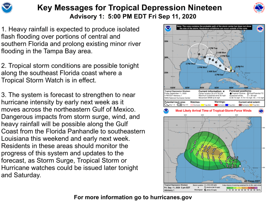
As of 5PM on Friday afternoon, September 11, Topical Depression 19 had formed off the east coast of Florida and was headed for the Gulf. According to Jeff Lindner, Harris County Meteorologist, “Deep convection has developed near or over the likely location of the surface center. The system is overall fairly large in nature with several curved bands.”
TS Watch Already Issued for the SE Florida Coast
The National Hurricane Center has already issued a tropical storm warning for the SE coast of Florida.
Tropical storm or hurricane watches will likely be required tomorrow for portions of the central US Gulf Coast.
National Hurricane Center
Track
Tropical Depression 19 is moving toward the WNW around 8mph. This motion should continue for the next 24-48 hours. There is some uncertainty in the forecast track, but right now the depression is forecast to approach the central US Gulf coast early next week. It could ravage some of the same areas hit by Hurricane Laura.
Cone of uncertainty for TD19. Remember, the storm has an equal chance of tracking anywhere within the cone. The cone does not indicate the storm’s width.Tropical storm force wind probabilities for the next 120 hours (3 days). As of 2PM Friday, September 11.
Intensity
According to Linder, “Tropical Depression 19 could already be nearing topical-storm intensity. Conditions ahead of the system look generally favorable for development with light shear, a good moisture envelope, and very warm sea surface temperatures.” He adds that models diverge in their forecasts: some bring the system to a hurricane while many show a stronger tropical storm. NHC brings the system to a 70mph tropical storm. “But it is very possible that a hurricane will be approaching the central US Gulf coast early next week,” says Lindner.
Monitor weather forecasts closely for the next few days.
Posted by Bob Rehak on September 11, 2020
1109 Days since Hurricane Harvey and 19 years since the Twin Tower Attacks
https://i0.wp.com/reduceflooding.com/wp-content/uploads/2020/09/205735_5day_cone_no_line_and_wind.png?fit=897%2C736&ssl=1736897adminadmin2020-09-11 18:01:592020-09-11 18:02:11Tropical Depression 19 Predicted to Become Tropical Storm or Possibly Hurricane In Gulf Next Week
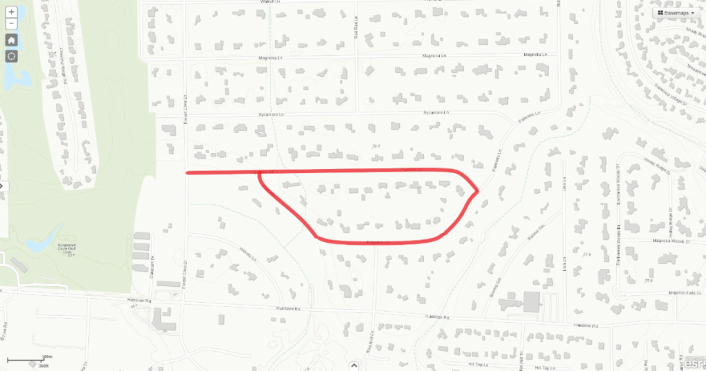
The project area includes Cypress Lane and Palmetto Lane. The map above shows the project limits highlighted in red.
Scope of Work
The scope of work for the ditch rehabilitation project includes:
Regrading and re-establishing of the roadside ditches
Replacing of the culverts and resetting them to match the flow line of the ditch
Replacing the driveway where the culverts are replaced
Increasing the capacity of any culverts less than 24 inches in diameter
Removing any unpermitted culverts or other encroachments in the City Right of Way.
Project Approximately on Schedule
I drove by the project earlier in the week and it appeared that the City had completed approximately a quarter to a third of the project in about a quarter of the time. That means they are on schedule or slightly ahead.
Ditch rehab already completed in Forest Cove
From the looks of things, it appears the City is doing exactly what it promised.
For More Information
For more information, please contact Mayor Pro Tem Dave Martin’s office at (832) 393-3008 or via email at districte@houstontx.gov.
Posted by Bob Rehak on 9/10/2020
1108 Days after Hurricane Harvey
https://i0.wp.com/reduceflooding.com/wp-content/uploads/2020/09/20200902-RJR_0221.jpg?fit=1200%2C800&ssl=18001200adminadmin2020-09-10 17:02:562020-09-10 17:03:13City Making Good Progress on Forest Cove Ditch Rehabilitation Project
Source: NHC. Peak of season occurs on September 10.
“The official hurricane season for the Atlantic Basin (the Atlantic Ocean, the Caribbean Sea, and the Gulf of Mexico) is from 1 June to 30 November. As seen in the graph above, the peak of the season is from mid-August to late October. However, deadly hurricanes can occur anytime in the hurricane season,” warns the NHC.
Average Number of Storms
Source; NHC
In an average season, we get 11 or 12 named storms, six of which become hurricanes and two or three of which become major hurricanes (category 3 or greater).
Twelve storms would get you to the letter L. But so far this year, we’re already on the R storm. And we have three more months to go in the season.
Points of Origin Tend to Shift by Month
The NHC shows where hurricanes tend to form each month of the season. In the first ten days of September, more hurricanes form in the Gulf than at any other time. The NHC shows a whole series of charts like the one below. It’s interesting to see how they change from period to period.
Source: NHC. Sept. 1-10 and Sept. 11-20 show the greatest number of hurricanes forming in the Gulf.
Note how few storms formed in the Caribbean compared to the period from October 11 to 20.
Compared to September 1-10, note how many more storms formed in the Caribbean during October 11-20.
Track Probabilities Also Shift by Month
The NHC also shows an interesting series of charts that show track probabilities by month. September is the most likely month for storms to track through the Caribbean, into the Gulf and onward to the Texas coast.
Source: NHC
Source: NHC
In stark contrast, during October, storms are most likely to veer east toward Florida and the East Coast.
Strike Density on Western Gulf Coast
Source: NHC
On the Texas Gulf Coast, Galveston has been hit more times than any other county. Harris, Brazoria and Chambers Counties follow closely.
Today’s Five Day Tropical Outlook
As if on cue, the NHC is now tracking seven tropical disturbances (as of 800 AM EDT Thu Sep 10 2020).
The two closest to Texas are highlighted in yellow above. That means they currently have less than a 40% chance of formation.
A large area of disorganized showers and thunderstorms near the Bahamas is forecast to move westward, crossing Florida on Friday and moving into the eastern Gulf of Mexico over the weekend. Upper-level winds are expected to become conducive for some development of this system while it moves slowly west-northwestward over the eastern Gulf of Mexico early next week. Formation chance through 5 days is 30 percent.
Another trough of low pressure has developed over the northeastern Gulf of Mexico and is producing a few disorganized showers and thunderstorms. Some slow development of this system is possible while this system moves westward and then southwestward over the northern and western Gulf of Mexico through early next week. Formation chance through through 5 days is even lower, at 20 percent.
Posted by Bob Rehak on 9/10/2020
1108 Days since Hurricane Harvey
https://i0.wp.com/reduceflooding.com/wp-content/uploads/2020/09/peakofseason.gif?fit=831%2C546&ssl=1546831adminadmin2020-09-10 11:34:142020-09-10 11:34:38Today is Statistical Peak of Hurricane Season
San Jacinto River Authority (SJRA) will hold public meeting on Thursday, September 10, 2020, at 6:00 p.m., via webinar and telephone conference, to discuss its ongoing Lake Conroe Reservoir Forecasting Tool Project.
Accurately determining inflow during a flood theoretically lets dam operators determine how much water to release and when. That, in turn, helps protect properties both upstream and downstream to the extent possible.
Senior residents of Kingwood Village Estates trying to escape as Harvey’s floodwaters rose.
Additional Information
The Lake Conroe Reservoir Forecasting Tool Project addresses flood protection in the San Jacinto River Watershed.
One goal: to anticipate peak water level in Lake Conroe during rainfall events based on:
Weather forecasts
Observed rainfall
Lake levels
Other data.
A second goal: to predict peak release rates of stormwater from Lake Conroe.
The SJRA says this will help improve communication with Offices of Emergency Management and the general public during rainfall events.
SJRA expects completion of the project by early spring 2021. The Texas Water Development Board (TWDB) and SJRA have funded the project.
Ask Questions, Express Views
You can view and participate in the meeting remotely via the webinar link below to express your views of the Project.
Questions or requests for additional information about the SJRA Reservoir Forecasting Tool may be directed to Mr. Matt Barrett, P.E., Division Engineer, SJRA, 1577 Dam Site Road, Conroe, Montgomery County, Texas 77304, Tel. (936) 588-3111.
SJRA requests those who intend to express their views to contact Mr. Barrett either in writing or by telephone in advance of the meeting.
To Participate Via Webinar and/or Comment
Only those participating via Webinar using the GoToWebinar App will be able to provide comments during the meeting.
If you choose to participate via conference call using the number below, you will NOT have the opportunity to provide comments during the designated portion of the meeting. The conference call phone number is provided for LISTENING PURPOSES ONLY.
Telephone conference call phone number: (562) 247-8321 and the audio access code is 150-445-802
Editorial Comment
I, for one, hope they use their new Reservoir Forecasting Tool to release floodwater at safe rates, although that was not explicitly stated in the SJRA press release on the meeting. Releasing at safer rates may mean releasing water earlier or holding it longer to flatten peaks. In my opinion, SJRA should hold floodwater as high as they safely can…as long as they safely can. I hope this new tool helps SJRA do that.
I’d rather see floodwater in Lake Conroe than in Kingwood’s Town Center.
Kingwood Town Center Apartments after Lake Conroe Release. Yes, that’s the top of an SUV that failed to evacuate in time.
Posted by Bob Rehak on September 9th, 2020
1107 Days since Hurricane Harvey
https://i0.wp.com/reduceflooding.com/wp-content/uploads/2020/01/Kingwood-Town-Center-Apts.jpg?fit=1200%2C563&ssl=15631200adminadmin2020-09-09 14:18:192020-09-09 14:48:09SJRA Considering Input on Lake Conroe Reservoir Forecasting Tool Thursday, 6PM
Nicole Black-Rudolph captured these two photos downstream from Woodridge. They show the water in Taylor Gully at the Turtle Bridge in Woodstream. The first shows what the water normally looks like. The second shows what it looks like now.
Normal/Now Photos by Nicole Black-Rudolph showing increased silt in Taylor Gully.
Where Did Silt-Laden Water Come From?
Following Taylor Gully upstream, you come to 268 clear-cut acres – Perry Homes’ Woodridge Village. All pictures below show Woodridge Village on the morning of September 7, 2020. A nearby Elm Grove resident, Jeff Miller, reported .7 inches of rain fell in his gauge on 9/5 and 9/6. That wasn’t enough to cause flooding, but it was certainly enough to erode sediment as the pictures below show.
Looking SSW across Woodridge from the top of the N3 detention pond on the eastern border. Elm Grove is at top. Everything slopes toward Taylor Gully in the upper left.Woodridge Village, looking NW from over Taylor GullyLooking north at N3 detention pond day after rainfall. Silty water is still flowing out of the pond.Looking east at the concrete lined portion of Taylor Gully on the Woodridge site where water exits the site and crosses into the open channel on the Harris County side of the county line, out of frame to the right (see below).Looking south at Taylor Gully immediately south of the county line. Note how color of water in ditch matches the color of water on the right in the side-by-side comparison photo above.
Now, despite best efforts to reduce erosion with conventional countermeasures, the exposed surface washes downstream with each rain. This re-deposits more sediment, which the Flood Control District just removed. (See two photos below from 2019.)
Taylor Gully Before 2019 Clean out.
Taylor Gully After 2019 Clean Out
Pray there’s movement on this deal soon. Perry Homes should plant grass on their property until the ping-pong match is over. Silt fences and rock baskets alone just don’t do the job.
Posted by Bob Rehak on 9/8/2020 with photos from Nicole Black-Rudolph and Rain Data from Jeff Miller
1106 Days since Hurricane Harveyand 355 since Imelda
The thoughts expressed in this post represent opinions on matters of public concern and safety. They are protected by the First Amendment of the US Constitution and the Anti-SLAPP Statute of the Great State of Texas.
https://i0.wp.com/reduceflooding.com/wp-content/uploads/2020/09/Taylor-Gully-Silt.jpg?fit=1200%2C800&ssl=18001200adminadmin2020-09-08 14:37:012020-09-08 14:40:40Woodridge Village Still Silting Up Taylor Gully
It’s the heart of the storm season. It’s going to be an interesting next several weeks as we look toward the sea. Buy flood insurance. ANY place in Harris County can flood, don’t be another surprised flooding victim. “I’ve never flooded before” will not get you much sympathy anymore, we have heard it too much.
Rice U Assesses Cypress Creek Situation
In 1984 Dr. Phil Bedient, of Rice University, wrote his first research paper on flooding along Cypress Creek. At the time he said the cause was too much development with no place for the water to go. In 2018 Dr. Bedient, as head of Rice’s Severe Storms Center, wrote another paper on flooding on Cypress Creek.
He said the cause was too much development with no place for the water to go – too much run off.
One of his co-authors told us that even if a dam was erected on the creek at 290, and another dam erected at the junction with Little Cypress Creek, the main stem of the creek would still flood. Too much run off, no place for the water to go. And too much unbridled development.
We all bewailed the Arizona developer who brought eight (8) feet of fill onto the 50 acres at the Vintage, on Vintage Preserve Pkwy., to build apartments. He installed detention to capture the run off on that 50 acres, but what of the water that used to pool there during floods, where does it go? He produced an engineering study saying “no adverse impact”, but where does that water go?
Rebuilding Next to Buyouts!
We recently visited a Harris County home buy out focus site in Saracen Park on Cypress Creek. There were several vacant lots where residents had sold out to FEMA to escape repeated flooding. Immediately adjacent to these properties, which were purchased with federal tax dollars, was a new home being constructed. It was a spec home being erected by a builder – “for sale by owner”. The County verified that the builder had the proper permits to build in the floodway. Not flood plain, floodway – the stream channel.
Is There No Other Land?
Harris County allows building in the stream channel. Why? Is there no other land? Or is this land just really cheap because it’s in the floodway? Why spend tax dollars to buy out properties and, in turn, allow more properties to be built there? What sense does this make? Who are the stewards of our tax money?
Harris County is one of the few places in the country which allows building in the floodway. As one of our state representatives told us, it is difficult to obtain state funding for flood mitigation in Harris County when other representatives from around the state ask: “Well, why ya’ll allow building in the flood plain, anyhow?” How does one answer that?
Fill Without Permit and Slap-on-Wrist Fine
At the corner of Cypresswood Drive and Champions Forest Drive a developer, Don Hand, recently brought in 5-6 feet of fill to build up his lot for a construction project.
He didn’t bother to obtain a permit. There was no detention built and no consideration for his neighbors.
If a tropical storm had arrived, the water would have cascaded off that lot into the Chase branch bank, crossed the street into the Mormon Temple, flooded the Conservatory parking lot, inundated Cypresswood Drive and perhaps entered the Kroger, again. Citizen outrage caused the County to ‘red flag’ his construction.
The County was required to go to court to obtain an injunction to stop this developer and require the fill to be removed. It was a pyritic victory. The penalty assessed under the law against this type of dangerous develop is $100/day. Little wonder the dirt is still there – it’s cheaper to pay the fine than remove it.
3600 Building Permits Issued Along Cypress Creek Since 1997
Development continues apace along Cypress Creek. Community Impact’s investigation into development along the creek indicates that since the 1997 county standards were adopted, there have been over 3,600 new building permits issued along the creek. More impervious surface, less room for the water.
Subsidizing Developers with Taxpayer Dollars
The Greater Houston Flood Consortium’s 2017 report on flooding and building standards recited that “…not requiring new development to fully mitigate its impacts would essentially be a subsidy for that development, reducing the cost of building but ultimately requiring taxpayers to pay for more new flood mitigation infrastructure and saddling downstream residents with flood-related property damages.”
The Politics of Development
How did we get so far out of balance? For a century builders & developers have had a powerful hold on Houston and Harris County. Recall the 1960s mayor of Houston, Louie Welch, and his statement: “The business of Houston is business”. No zoning, weak regulation.
Another reason is money. County regulations are approved by Commissioner’s Court. In 2018 a Houston Chronicle investigative report indicated that all four commissioners received at least 80% of their re-election funds from builders/developers/engineering firms. While all the commissioners deny that these election contributions have any impact on their decisions, you can bet the donors get their phone calls returned.
Luck Not a Strategy
Thus far in this very active hurricane season we have been lucky and dodged all the storms. In flood mitigation, luck is not a strategy. We must have flood infrastructure. Three years after Harvey, four years after Tax Day, not a shovel of dirt has turned on Cypress Creek. But we must also have reasonable rules which look after not only developer profits, but public safety and security. Tell your friends, tell you neighbors, tell your elected representatives. Let’s start that conversation.
https://i0.wp.com/reduceflooding.com/wp-content/uploads/2020/09/cropped-img_26511104.jpg?fit=479%2C479&ssl=1479479adminadmin2020-09-07 19:18:332020-09-07 19:18:45Developing Problem
Texas Water Development Board (TWDB) is trying to make flood-related information more accessible and user friendly via an update of their website, TexasFlood.org. The refreshed website will become a one-stop shop for flood-related data and information throughout the state. Please review it and then give TWDB your input via this short survey. Make sure they’re providing the kind of information YOU want.
In 2019, the Texas Legislature and Governor Abbott greatly expanded the Texas Water Development Board’s (TWDB) role in flood mapping, planning, and financing.
In addition to existing flood programs, TWDB will administer a new state and regional flood planning process, increase flood-related financial assistance, and advance flood modeling and mapping capacities.
As the agency expands data, information, and resources related to flooding in Texas, a key priority is to ensure that flood-related information is timely, user friendly, and easy to find.
TWDB
So judge the new website against those goals.
Purpose of Survey
The purpose of the survey is to understand:
What flood-related information you find most valuable
How best to present that information on the new version of the site.
Less Than Ten Minutes Will Help Texans Better Prepare for Next Flood
Until now, the TWDB web presence has largely been geared toward water professionals. This site however, targets ordinary citizens. It’s a fresh approach for the Board. The home page for instance, starts with a discussion of what to do before, during and after a flood. You can drill down from there.
The survey should only require 5 to 10 minutes. Hurry. The last day is September 8. So please take the survey today. Your help will benefit Texans for years to come.
https://i0.wp.com/reduceflooding.com/wp-content/uploads/2020/09/TexasFlood.org-Home-Page.jpg?fit=1500%2C955&ssl=19551500adminadmin2020-09-07 10:58:292020-09-07 11:01:27Texas Water Development Board Wants Input on Their New TexasFlood.org
If you fear flooding from a small stream and you live inside the Houston City limits, this is THE resource for you. It’s the City’s Water Flood Hazards Viewer. And it’s incredibly detailed. It even shows the extent of flood hazards around many unnamed temporary streams and man-made ditches.
The image above shows Ben’s Branch where it cuts across the Harris/Montgomery County Line. Many homes and businesses in this area flooded during Harvey and Imelda despite being three miles from the nearest river.
The different shadings and cross-hatchings represent floodways, 100-year and 500-year floodplains. I checked around neighborhoods near me where I was familiar with the extent of flooding. The map seems to be very accurate. I only found one or two properties that I would have reclassified.
Impressive Gallery of Base Maps and Other Features
The City’s Water Flood Hazards site contains an impressive gallery of 25 different base map options. They range from customary street maps and satellite views to topographic maps and more.
You can also measure distance and direction with the built in tools. And unlike many such maps, this one contains built in drawing tools that let you make notations and share them with your friends or associates.
Of course, it includes information on flood zones near major rivers, too. It even includes information on hurricane evacuation zones near the coast.
You can see the outlines of Harris County in the extent of the waterways. The bright areas near the coast represent hurricane evacuation zones and zip codes.
Incredible Flexibility
Because the system is built on a geographic information system database, you can even add data from other databases. That makes the map reflect additional types of information. But warning: this can get very technical.
Great Tool for Research
If you’re considering buying a property or flood insurance, and you live in the City or Harris County, this is definitely a map you should bookmark. The Water Flood Hazards Map is an incredible research tool. For ease of future reference, I have listed the map on the Links page of this website under Floodplain Maps and Elevation.
Posted by Bob Rehak on 9/6/2020
1104 Days after Hurricane Harvey
https://i0.wp.com/reduceflooding.com/wp-content/uploads/2020/09/North-Park-BB-City-Water-Flood-Map.jpg?fit=1200%2C733&ssl=17331200adminadmin2020-09-06 18:59:422020-09-06 18:59:54City of Houston Map Shows Extent of Water Flood Hazards for Many Smaller Ditches, Streams
FEMA has agreed to dredge another million cubic yards from the the area near the San Jacinto West Fork Mouth Bar. A report produced for the City of Houston by Tetra Tech helped convince FEMA. The report relied on sonar, LIDAR, and core sample data to estimate the total volume of sand deposited by Hurricane Harvey in that area: approximately 1.4 million cubic yards.
Those close to the project have discussed several strategies to date.
The Corps’ initial strategy: Dredge upstream from the mouth bar. They said 1D modeling showed that would accelerate water flowing into mouth bar and give it the velocity needed to push sand from the mouth bar farther out into the lake.
Another strategy: dredge downstream from the mouth bar and let the river push the mouth bar into the dredged area.
A third strategy: reconnect the river and the lake with a narrow channel that accelerated the flow of water and carried suspended sediment out into the broader lake south of the 1960 bridge.
2019 Tetra Tech Report
Stephen Costello, the City’s flood czar, says that new survey and modeling work has yet to be completed. That will ultimately determine where new dredging happens. However, he also added that consulting Tetra Tech’s exhibits would help provide clues as to where dredging might be most effective, based on knowledge accumulated to date.
The first chart in Appendix A showed the coring locations and transects (survey lines) of the lake’s bottom profile.The second chart shows what they foundin various coring locations.The feet indicate the thickness of the top layer.
Composition of the core samples provides clues as to what was laid down when. Sand (the yellow dots) is generally laid down during floods which have the energy to transport the heavy particles. However, clay and silt (the green and blue dots) are smaller. So they tend to drop out of suspension when water is calmer.
Finding sand above silt in a core sample indicates that a storm like Harvey likely laid down the sand.
The third chart is the most crucial. It’s a difference map that shows areas of deposition and scour pre- and post-Harvey. This shows two things: where most sediment fell out of suspension and where the main flow of the river tried to churn a path through the mounting muck.
From the difference map above, you can see that the river tried to scour its way through the sediment along a path from LH-16 to LH-21 to LH-23. You can see another area of scour to the far right from LH-15 to LH-25 to LH-26.
Where River Flowed Before Lake Was Impounded
Interestingly, the area of scour to the left follows the river’s relic channel.
San Jacinto River map before Lake Houston was impounded
Note how the West Fork hugged what is now Atascocita Point – the thumb of high land that sticks up in the Tetra Tech illustrations.
Harnessing Natural Energy of the River
From the third and fourth illustrations above, one might conclude that excavating a channel near Atascocita Point represents the best way to harness the natural energy of the river. That’s the shortest channel where scour is deepest.
Given the million cubic yard limit, that path also represents a chance to dig the deepest, widest channel possible within the budget. When technicians compiled the difference map above, most of that path was already at or below its 2011 level.
500,000 square-yard path outlined in yellow would let dredgers excavate six feet. Average bottom depth is already 5.5 feet in that area.
Following that path also lets you funnel future sediment through the FM1960 causeway and disperse it out into the wider, deeper lake.
Before the additional dredging can begin, several things must happen.
Completion of a new survey
Model different scenarios
Identify best strategy
Locate suitable placement area
Compile scope of work
Bid job
Mobilize
Based on past experience, that could take months to a year or more. It took 13 months after Harvey for the Corps to put equipment in the water for its Emergency West Fork Dredging Project. However, we don’t have as many unknowns this time.
Posted by Bob Rehak on 9/5/2020
1103 Days since Hurricane Harvey
https://i0.wp.com/reduceflooding.com/wp-content/uploads/2020/09/Tetra-Tech-Study_Page_26.jpg?fit=2550%2C1650&ssl=116502550adminadmin2020-09-05 15:39:592020-09-05 15:53:16Tetra Tech Study Provides Clues To Possible Mouth Bar Dredging Strategies