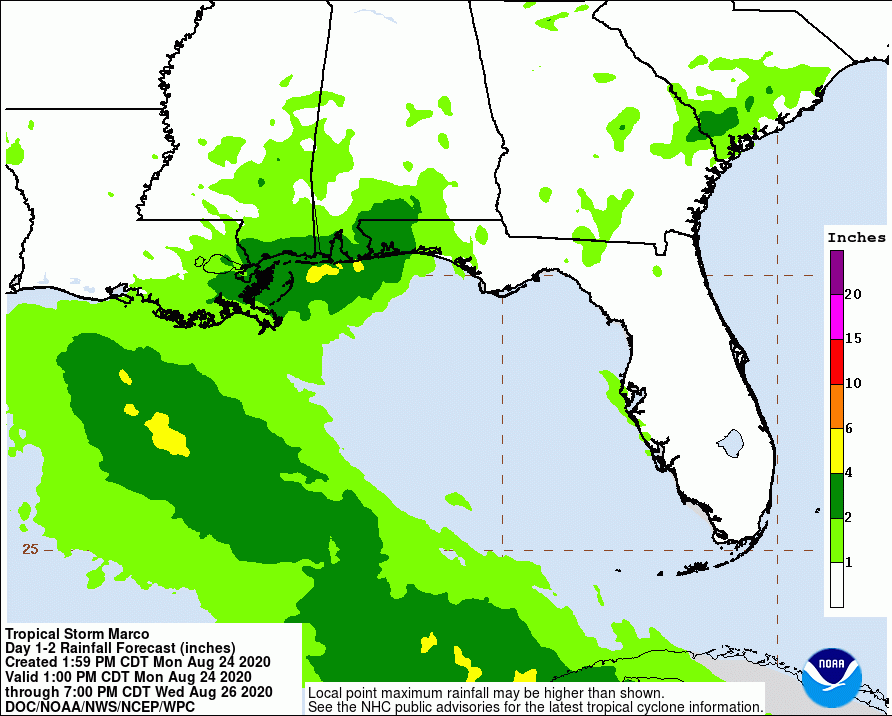
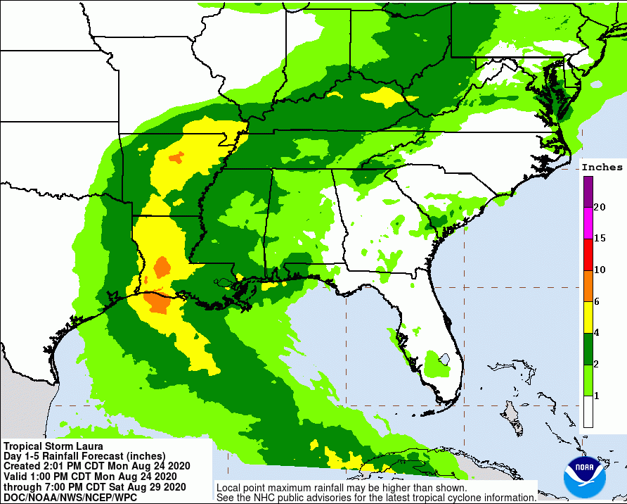
HCFCD About to Start Next Phase of Kingwood Diversion Ditch Repairs

On Monday, July 13, Harris County Flood Control District (HCFCD) plans to begin more repairs to the Kingwood Diversion Ditch. In June, HCFCD repaired severe erosion near Walnut Lane between Trailwood and Forest Cove. The new repairs will begin farther down the ditch between Forest Cove and Deer Ridge Estates, just north of Deer Springs Drive. See map below.

Area of new repairs outlined in red. For reference, Kingwood’s Deer Ridge Park is in upper right. The outlined area shows where trees will be removed and is approximate.

Ditch To Be Straightened, Erosion Repaired

HCFCD plans to straighten the ditch and repair erosion. That will require the removal of trees which have grown up in the ditch and along its banks. See below.

In the area to be repaired, erosion and vegetation have made the ditch deviate from its normal course over time. The red line indicates the original path. The purple line indicates the current patch. Source: HCFCD.
Severe erosion threatens trails, safety and homes on both sides of the ditch.
Trees have grown up in the ditch, reducing its conveyance and blocking floodwaters.
To repair erosion and restore ditch, trees will need to be removed.

Bird Survey Finds No Nests Impacted

HCFCD has not specified the number of trees it will remove. However, the District has conducted a Bird Survey to ensure repairs will not impact any active nests near the portion of the Kingwood Diversion Ditch undergoing repair.

Protecting Homes from Future Erosion

“We will work to minimize the impacts to trees and nature, but we need to be able to get our equipment in to make repairs,” said Beth Walters, a spokesperson for HCFCD. “We do not know exactly how many trees will need to be removed. Unfortunately, it will be noticeable, but the repair will protect fences and homes from future erosion.”

Property threatened by diversion ditch erosion. Photo from January 2019.

Posted by Bob Rehak on 7/8/2020

1044 Days since Hurricane Harvey

Details of Proposed Lake Houston-Lake Conroe Reservoir Joint Operations Grant

On June 15, the SJRA submitted an abridged application to the Texas Water Development Board (TWDB). The SJRA wants to develop a joint operations plan for Lake Houston and Lake Conroe reservoirs. The grant assumes that FEMA approves construction of additional gates for Lake Houston after completion of preliminary engineering in the second half of next year. The addition of gates could potentially make a pre-release strategy for Lake Houston more viable and that could be a game changer for operations of both dams.

If the floodgates on the Lake Houston spillway are upgraded to discharge as much water as Lake Conroe’s, there will be a definite need to rethink how these two dissimilar dams can work together.

About the TWDB Application Process

The TWDB website explains the application process and eligibility requirements for grants from the Flood Infrastructure Fund. State Senator Brandon Creighton’s SB7 made the Flood Infrastructure Fund possible in 2019.

The Flood Infrastructure Fund applications are a two-step process: Abridged Applications provide the TWDB with information needed to prioritize projects. Applicants whose projects rank within the program’s available capacity are invited to submit full financial-assistance applications at a later date. Those provide more detailed financial, legal, engineering, and other information. Once the full review process is complete, the TWDB will consider project funding.

The two stage process ensures:

  • Projects meet criteria before applicants invest the vast majority of their time and effort
  • TWDB has enough money to fund the most worthy projects

It’s much like getting a commitment letter from a bank before you fill out a full mortgage application.

Why Joint Operations Plan Needed

Widespread flooding in the Lake Houston Area during Hurricane Harvey underscored the need for a joint operations plan with Lake Conroe. Many downstream residents reported they thought the flood threat had passed. Then the SJRA opened its flood gates and started releasing up to 79,000 cubic feet per second. By itself, that would have been the 9th largest flood in West Fork history.

Those who flooded question the timing and volume of the release, and whether a pre-release strategy could have reduced downstream damage.

Once additional gates are in place at Lake Houston, says the SJRA in its application, a joint operations plan will benefit both water supply and flood mitigation.

Objective of Plan

The main goal of the plan is to determine:

  • The most efficient and safe operation of the two reservoirs…
  • in series
  • … by evaluating multiple individual components of operational strategy.

Components of Joint Plan

Informing Future Protocol for Lake Houston Gates

SJRA suggests that information and strategies developed as part of this effort could impact the development of CWA’s operating protocol for the future Lake Houston gates.

Joint Notification Protocol Development

The river authority also says that it is important that both reservoir operators develop joint notification protocols and public communication strategies. These must be consistent with the requirements of House Bill 26 passed during the 86th Texas Legislative Session. During Harvey, many downstream residents claim they received no warning of the SJRA release or the need to evacuate.

Forecasting Tools

Another major part of the grant covers forecasting tools. SJRA is currently developing a reservoir forecasting tool for Lake Conroe, funded partially via a grant from TWDB. It will predict lake levels and release rates from the Lake Conroe dam based on:

  • Weather forecasts
  • Observed rainfall
  • Lake levels
  • Other data.

A similar tool for Lake Houston could help synchronize forecasting for both reservoirs including the entire Lake Houston watershed (approximately 3,000 square miles). This could provide scientific data that governs pre-release at either reservoir and operations at Lake Houston.

Average Monthly Household Income in Project Scoring

Much of the application discusses demographics of the watershed. The TWDB scoring process gives preference to rural and low-to-moderate income areas. References to AMHI refer to Average Monthly Household Income. Unfortunately (for grant purposes), the AMHI for this watershed is 164% of the state average.

That limits the maximum amount of a grant to 50% of the project cost. A social vulnerability index also acts as a tie breaker.

Next Steps in Application Process

  • The TWDB is currently screening and prioritizing abridged applications for projects.
  • Before the end of the summer, TWDB will invite extended applications for the high priority projects.
  • Extended applications are due this Fall.
  • TWDB will begin making financial commitments this winter.

For the full text of the abridged grant application, click here.

Posted by Bob Rehak on 7/7/2020

1043 Days after Hurricane Harvey

One Year Ago Tonight, Flooded Townhomes Burned for Third Time Since Harvey

On July 4, 2019, 10 pieces of fire equipment responded to a fire at the Forest Cove Townhomes on Timberline Drive. It was the second fire that week and the third that year. Unfortunately, the townhomes that burned that night still stand.

Remnants of fire one year ago still stand today.

The once-beautiful townhomes, in the floodway of the West Fork, were designed to have first floors that flooded. But Harvey’s raging floodwaters reached well into the second floors. 240,000 cubic feet per second raging down the West Fork didn’t leave much. After Harvey, structural instability made these townhomes unsafe and uninhabitable.

Townhomes on Aqua Vista in Forest Cove that were demolished by Harvey and then HCFCD.

Then came the squatters, looters, illegal dumpers and graffiti artists. FEMA made these townhomes the centerpiece of a 2018 video. Little has changed since then, a stain on the Agency’s reputation.

Almost three years after Harvey, little has changed except for the accumulation of discarded mattresses and couches that grows larger every week.

Buyout of Townhomes Slow and Cumbersome

Today, Harris County Flood Control (HCFCD) has bought out and torn down several of the buildings within this complex. But the process is slow and cumbersome. HCFCD can tear nothing down until all units in a building have been bought.

Without pointing a finger at anyone, the entire process, which stretches from Marina Drive to Pennsylvania Avenue is a logistical nightmare. Such eyesores lower property values and drag down communities.

In some communities, burned homes can be condemned and torn down within 30 days. But the eyesore below has stood for a full year. It has attracted illegal dumping and and anti-social graffiti.

After viewing the image above, HCFCD said it would accelerate these buyouts. Resolution can’t come too soon for my taste. They serve only one purpose at this point – as a stark reminder not to build near a river.

Posted by Bob Rehak on July 4, 2020

1040 Days after Hurricane Harvey

Details of Four SJRA Grant Applications for TWDB Flood Infrastructure Funds

Yesterday, I ran an article about Texas Water Development Board (TWDB) Flood-Infrastructure-Fund Grant Applications. It incorrectly stated that the City of Houston had applied for six flood infrastructure fund grants. However, five of those listed were actually submitted by other entities, such as the San Jacinto River Authority (SJRA). Below is more information about those grant applications.

Elm Grove Project Correctly Attributed to City

The City did apply for a grant to fund construction of a detention basin on the Perry Homes’ Woodridge Village Property north of Elm Grove Village in Kingwood. It was correctly attributed.

Four Projects Should Have Been Attributed to SJRA

The SJRA submitted four of the five applications that were incorrectly attributed.

  1. San Jacinto River Sand Trap Development
  2. Spring Creek Watershed Flood Control Dams Conceptual Engineering
  3. Upper San Jacinto River Basin Regional Sedimentation Study
  4. Lake Conroe-Lake Houston Joint Reservoir Operations Study

Mayor Pro Tem and District E Council Member Dave Martin personally supported those projects, hence the confusion. TWDB rules for Flood Infrastructure Fund Grants place a premium on support by all affected governmental entities within a watershed. Those include cities, counties, MUDs, river authorities, townships, etc.

Details of SJRA Grant Applications

Here’s more information about those four proposals.

  1. The Sand Trap Study currently underway has to do with identifying acceptable locations for the sand traps. Once identified, the new grant would cover the cost of their detailed design. The proposed study would extend work currently underway.
  2. The Spring Creek Watershed Flood Control Dams Conceptual Engineering Grant would cover the cost of partially designing dams. The San Jacinto River Basin Study identified locations for the dams. But it did not look at construction details. The new study would look at things, such as environmental impacts, utility conflicts, height of embankments, size of reservoir, etc. It continues work to date in the Spring Creek Watershed. San Jacinto River Basin Study partners have not yet released the locations.
  3. The Regional Sedimentation study builds on KBR’s work in 2000. KBR studied portions of the watershed that drain into Lake Houston, but not the East Fork, Caney Creek and Peach Creek. The new study has two objectives: understand where sediment is coming from and what can be done to reduce it. For instance, if the sediment is coming from new developments or sand mines, there may be a need to look at regulations that affect those.
  4. The Lake Conroe-Lake Houston Joint Reservoir Operations Study would look at the best ways to operate the two dams under different storm scenarios. It would assume the construction of additional floodgates on Lake Houston. It would also model storms approaching from different directions. The study will answer questions, such as “What would the effect of pre-releasing water into Galveston Bay be on Cities such as Baytown if a hurricane approaches from the south?” The deliverable: an operations plan.

Sedimentation and Its Role in Flooding

Two large sources of sediment: sand mines and new developments. Here the drainage for the Artavia development tries to find a path to the West Fork, through or around two sand mines. One of the mines was cited by the TCEQ for discharging 56-million gallons of sediment-laden wastewater into the West Fork.
The City, County, State and Federal Government are still working to remove the West Fork Mouth Bar, 1040 days after Hurricane Harvey. This bar is partially the result of excess sedimentation. During Harvey, this bar formed a partial dam that contributed to the flooding of more than 4000 homes and businesses.

More East Fork Gages in San Jacinto County

In addition, the SJRA has applied for a grant to purchase several more stream gages in San Jacinto County. San Jacinto County lies between Cleveland and Lake Livingston.

San Jacinto County partnered with the SJRA on that grant and would provide ongoing maintenance and operations if the application is successful.

Benefits of Additional Gages

Those additional gages would extend the flood-warning time for people in the East Fork Watershed. Such information is crucial for developing evacuation plans in emergencies.

The gages would also help inform the gate operations at Lake Houston. During Imelda, the East Fork received ten times more rain than the West Fork, but the West Fork has far more gages. That hindered understanding of where the danger was coming from and when it would strike.

As news becomes available about other grant applications in the San Jacinto Watershed, I will post it here.

Posted by Bob Rehak on 7/4/2020

1040 Days after Hurricane Harvey

City Applies for TWDB Grants to Turn Woodridge Village Into Detention Basin and More

Correction on 7/4/2020: The article below was based on a City of Houston District E newsletter. It inferred that the City “applied for” five grants (in bullet points below). Other entities, such as the SJRA, applied for those. Mayor Pro Tem Dave Martin personally supports them.

The City of Houston has submitted several applications to the Texas Water Development Board (TWDB) for Flood Infrastructure Fund dollars. Among the projects was one for Taylor Gully Flood Damage Reduction. It consists of evaluating flood reduction alternatives plus design, permitting, and construction of a detention basin located on a 278 acre site to the north of the Elm Grove subdivision.

Looking SW at Woodridge Village as of 6/16/2020

Woodridge Project One of Six Apps

Other applications include:

  • San Jacinto River Sand Trap Development
  • Spring Creek Watershed Flood Control Dams Conceptual Engineering
  • Upper San Jacinto River Basin Regional Sedimentation Study
  • Lake Conroe-Lake Houston Joint Reservoir Operations Study
  • Harris County MUD #153 Siltation Reduction

“All of these projects submitted for funding promote regional resiliency and future sustainability in an effort to protect life and property from future flooding,” said Mayor Pro Tem and District E City Council Member Dave Martin. “The ability to submit these projects to the TWDB for funding would not be possible without State Senator Brandon Creighton’s writing of Senate Bill 7. We continue to applaud the Senator for his forward thinking and hope to receive funding for these projects. State Representative Dan Huberty has also been a vocal proponent for resiliency within our area and just beyond the City boundary. We are thankful to have him as a local engaged leader.”

Looking NW from US59 (foreground) over San Jacinto West Fork at the confluence of Spring Creek (left) and the West Fork (right). Spring Creek splits off to left. Its watershed contains several natural areas that might make candidates for flood control dams.

Neither Martin, nor his office, provided additional details on any of the grant applications.

However, from the wording of the release, it sounds as though state leaders are fully aligned and engaged to support the projects.

Woodridge Village Project Has Long History

The grants, if approved, could help reduce flooding throughout the Lake Houston Area.

The Taylor Gully/Woodridge Village project is the most urgent. Homes around the troubled development flooded twice last year. At a Kingwood Townhall meeting in February, Martin said the County should pay for 100% of that project. But then the County demanded that the City should pay for half of the purchase price of the land. And at the next Commissioners’ Court meeting, Commissioner Ellis changed the deal again. He demanded that the City pay for half of the construction costs also.

Both the City and County have been silent on any deal since then. The County refused a Freedom of Information Act request to release the text of the motion, which was approved in a public meeting. They even protested release of the information to the State Attorney General.

Putting Application in Historical Context

The following is speculation, but speculation based on the historical context. It appears that when County Commissioners voted to demand that the City come up with half the the purchase AND construction costs, the City found it hard. The grant application, if successful, is a way for the City to help the people of Elm Grove, who flooded twice last year after Perry Homes cleared 268 acres of adjacent land.

At the time of the floods, less than 25% of the planned detention pond capacity was in place. Perry has since developed additional detention ponds that provide the other 75%.

However, even that probably won’t be enough to absorb a 100-year rain. That’s because Perry Homes rushed to have the project approved before NOAA’s new Atlas-14 precipitation frequency tables went into effect. The new Atlas-14 standard would require about 40% more detention capacity. And that’s what the purchase is all about.

Rumor has it that political forces are aligned to accelerate this particular request.

Observations on Other Grant Applications

Of the other applications, two surprise me.

A joint reservoir operations study seems necessary. Currently, FEMA is funding a preliminary engineering study to add additional gates to the Lake Houston Spillway. If FEMA also approved the money for construction of the gates, they will be a game changer.

The Spring Creek Watershed flood control dams would provide additional upstream detention. Community leaders identified that as a high priority after Harvey. They would reduce the amount of water coming downstream during a flood.

Harris County MUD #153 contains Lake Houston shoreline where silt from Rogers Gully has accumulated. Earlier this year, Harris County Flood Control cleared a large part of the Gully, but the part owned by the City remains clogged with a mouth bar.

Sand bar blocking mouth of Rogers Gully has backed up water and contributed to flooding. Photo taken 6/16/2020.

Posted by Bob Rehak on 7/3/2020

1039 Days since Hurricane Harvey

How TACA is Winning the Battle to Continue Pillaging Your Environment and Polluting Your Water

In March, as the pandemic spread across America, the Texas Aggregate and Concrete Association gave a presentation to a convention of industry producers in Las Vegas. The title: “Be Prepared: Protect your Operation from New Tactics in Community Opposition.”

Use of Internet Seen as New Tactic

As far as I can tell from the presentation, the new tactic is the use of the Internet. Wowsers! That’s quite an insight!

In the presentation, they specifically mentioned ReduceFlooding.com. I’m sure I anger these people as much as they anger me. I have met with them five times now. None of the meetings resulted in any change of industry practices. Or even a genuine willingness to explore them.

The Boy Scout Connection

In Austin during the last legislative session, a House committee member (evaluating a bill to establish best management practices for the industry) asked whether TACA had engaged with communities they affected. Mr. Rob Van Til (a mine owner and TACA spokesperson) looked at me waiting to testify, and said, “We’d prefer to talk to the Boy Scouts.” And just like that, the bill died in committee.

TACA sees people trying to protect their communities as the enemy. Instead of engaging with “the opposition” and trying to reform damaging mining practices, they rally support among neutral third parties.

TACA’s presentation in Las Vegas talked about:

  • How concrete supports Texas’ growth by providing essential infrastructure materials
  • Why “WeRTexas”
  • Teacher and school workshops they sponsored
  • Legislative and staff tours they promoted
  • Chamber of Commerce mixers
  • Quarry Days

They also patted themselves on the back for bicycle donations to a children’s charity in San Antonio.

Millions in Back-Door Political Contributions

TACA has also donated millions of dollars to legislators and state officials through a back-door political-action committee called TACPAC. Meanwhile, TACA has refused to acknowledge damaging practices and resisted all attempts to develop meaningful best management practices that address them.

Delivering Air Cover for Members

It’s tough for trade associations to tell members what to do. Loss of members means loss of funding for the association. For the most part, members want air cover from associations. And that’s what TACA delivers.

Communication experts on controversial issues divide the world into three camps: pro, undecided, and anti.

Conventional wisdom says you target messaging to pro and undecided groups. And that’s exactly what TACA is doing. Because you rarely swing anti’s.

For the record, I like concrete. I DON’T LIKE the irresponsible production of it. And what TACA never shows people and avoids talking about. So I will redouble my efforts. And continue advocating for responsible aggregate and concrete production.

Explain These to The Boy Scouts and Kids Clubs

Below is a tiny sampling of more than 10,000 aerial photos I have taken in the last eight months along the East and West Forks of the San Jacinto in southern Montgomery County.

Let’s turn these into murals at the State Capitol for TACA Day next year. Just so legislators get the full picture.

20 square miles of sand mines to the left up the West Fork.
One of eight breaches at Triple PG in October 2019. This one on Caney Creek.
Second of eight breaches at Triple PG in October 2019. This one on White Oak Creek.
Pumping wastewater into the West Fork
Confluence of West Fork (right) and Spring Creek on 11/4/2019.
The Day the West Fork Ran White. TCEQ traced this back to the LMI Mine upstream.
More pumping into the West Fork.
One part of a double breach at the Hallett Mine that blew out the sand bar on the opposite side of the West Fork.
Five pipelines carrying highly volatile liquids undermined at the LMI River Road mine.
Massive breach barely patched and ready to let loose again.
Equipment abandoned in floodway
LMI Moorehead mine. TCEQ traced white-water incident to here.
River Aggregate Mine on West Fork
LMI River Road Mine pouring into surrounding wetlands.
Pipe that automatically sends wastewater from mine into surrounding forest when level gets high enough.
Wastewater from LMI River Road mine leaking across neighbor’s property…
…where it enters sewer system under road and then empties into West Fork.
LMI Moorehead Mine pumping wastewater into surrounding forest where it can’t be seen by road or river. Eventually this drains back into West Fork
…which can be seen here (top) where it joins Spring Creek at 59.
Ditches or small streams go along the sides of every mine on the East and West Forks. Breaches and pumps are common along these. They make a secluded way to send water to the river.
River mining without a permit at Spring West Sand and Gravel on West Fork
That blue water is either high in chlorides or cyanobacteria.
Another wastewater leak from LMI River Road mine where it enters West Fork.

Unsolicited Advice to TACA

Dear TACA. If you want to protect your organization from community opposition, start cleaning up your act. That would be a new and truly effective tactic.

Posted by Bob Rehak on 7/3/2020

1039 Days after Hurricane Harvey

The thoughts expressed in this post represent opinions on matters of public concern and safety. They are protected by the First Amendment of the US Constitution and the Anti-SLAPP Statute of the Great State of Texas.

Humble ISD Constructing Transportation Facility Next to Woodridge Village

In 2018, voters approved an Humble ISD school bond that included a new northern transportation center. The 11.7-acre center is currently under construction at 24755 Ford Road, directly across the street from the new construction entrance for Woodridge Village. Concerned residents wonder whether the extra acreage could make flooding worse.

Source: Montgomery County Appraisal District

Humble ISD says the target opening date for the new transportation center is 2021. Having an additional transportation center will save an estimated $2 million in operating costs, they say, due to shorter routes and improved response times.

Transportation Centers Use Lots of Concrete

This video shows what the old bus center looks like. Lots of concrete! It is a giant parking lot. But the District does have two small detention ponds for the 29-acre site (see below).

Old Humble ISD transportation center at Will Clayton and Wilson. Note detention ponds and bottom and right of photo. Source: Google Earth.

Note that the old site is in Harris County and the new one is just across the county line in Montgomery County which has more lax regulations.

Residents Question Whether Site Will Add to Flooding

There is some good news, however. According to USGS, there were no wetlands on this site. Nor does FloodFactor.com for FEMA show that the Transportation Center is any danger of flooding, unlike its neighbor, Woodridge Village, to the west.

New Transportation Center property is by red pin. Woodridge Village is to left, across Ford Road. Source: FloodFactor.com.

Some residents have questioned whether the new transportation center will add to their flood woes. That’s unclear. It depends on whether the District puts detention ponds on the site.

Construction Photos As of 6/16/2020

Recent construction photos below suggest that they will, but the District has not yet responded to a request for a drainage analysis and site plan. See the status of construction below. All photos taken on 6/16/2020.

The cleared space on the right is the northeastern section of Woodridge Village. The one in the upper left by the cell tower is the new Humble ISD transportation center. Looking southeast toward Lake Houston in background.
Tighter shot of new transportation center shows clearing is complete. Area between cell tower and top corner looks like it could become a detention pond.
Even closer shot shows them laying stormwater sewers toward back corner.
Close shot of drain pipe. From the size, it looks as though they expect a lot of runoff.
It also looks like they are pouring a concrete bed for the pipe.

New Ag Barn Just Blocks Away

The District’s new ag barn will also be in the same vicinity, about two blocks south – right where Ford Road turns into Mills Branch Road. During the last bond election, shortly after Harvey, the District decided to relocate the ag barn from Deer Ridge Park for the safety of students and animals.

The District has just started clearing land for that project.

The high rate of development in this area makes it imperative that everyone adheres to drainage best practices to prevent flooding. As more information about these and other projects becomes available, I will post it.

Posted by Bob Rehak on 7/2/2020

1038 Days since Hurricane Harvey and 286 since Imelda

Triple P.G. Owner Transferred Ownership of Sand Mine Days After AG Filed Suit

Mere days after the Texas Attorney General (AG) filed a lawsuit against Triple P.G. Sand Development, the mine’s owner transferred ownership of the mine. Even though the transfer was recorded in October, the attorney general says the papers were dated for the prior January — before the unauthorized discharges from the mine that triggered the AG’s lawsuit.

Hundreds of Millions of Gallons of Wastewater Discharged

Two unauthorized discharges from the mine in Porter during May and September last year let hundreds of millions of gallons of sediment-laden wastewater escape into the headwaters of Lake Houston, the source of drinking water for 2 million people.

The putative ownership transfer was recorded in October, days after the lawsuit was filed. But it was dated for the prior January—before the May and September discharges that triggered the law suit!

Triple P.G. Mine in Porter. Photographed on 6/16/2020. Bright colors likely due to high chloride content or Cyanobacteria which may contain cyanotoxins.

Suspicious Ownership Transfer

The AG didn’t allege any motives. But the suspicious ownership transfer may have been an attempt to shield assets from prosecutors. People often set up multiple companies, trusts and partnerships to shield assets in one from lawsuits in another.

As a result of the transfer, the Texas Attorney General (AG) amended the State’s original petition and application for injunctive relief against Triple P.G. on 6/17/2020. The new petition added five additional defendants. They include:

  • Guniganti Family Property Holdings, L.L.C.
  • Prabhakar R. Guniganti, individually
  • Prabhakar R. Guniganti, as Director of Triple P.G. Sand Development, L.L.C.
  • Prabhakar R. Guniganti, as sole manager of Guniganti Family Property Holdings, L.L.C.
  • Guniganti Children’s 1999 Trust.

TCEQ Surprised by “Different Operator” at Facility

The Attorney General’s amended petition states, “In or around May 2020, prior to expiration of the Temporary Injunction, Texas Commission on Environmental Quality (TCEQ) investigators conducted a site visit and were informed that a different operator had taken over operations at the Facility.”

Ironically, instead of shielding assets (if that’s what he was trying to do), Guniganti exposed more of his family’s holdings. Now they’re all part of the lawsuit.

Guniganti Family Property Holdings, L.L.C. was the recorded property owner at the time of the May and September 2019 breaches. However, new ownership records now show that in October 2019, Guniganti Children’s 1999 Trust owned the property.

Prabhakar R. Guniganti is the sole director of Triple P.G. Sand Development and sole manager of the Guniganti Family Property Holdings. The AG’s amended petition alleges Guniganti orchestrated the ownership transfer as the sole manager of Defendant Guniganti Family Property Holdings.

Officially, the State filed the amended petition to name additional entities that are responsible for the 2019 discharges. They also share a continuing responsibility to prevent discharges in the future by performing corrective actions to improve the site.

Basis for Lawsuit

The TCEQ cited Triple P.G. in both months during 2019 for the unauthorized discharge of millions of gallons of sediment-laden process wastewater. In May, the entire contents of the Triple P.G. dredge pond (about 180 acres in area) were released into Caney Creek. TCEQ estimates 325 million gallons of sediment-laden water exited into Caney Creek, which leads directly to the East Fork of the San Jacinto River and onward to Lake Houston. Then, more breaches occurred in September, 2019.

Triple P.G. agreed to injunctive relief last fall. The injunction required Triple P.G. to cease dredging operations, to repair breaches, and to retain an engineer who would propose a plan to ensure the berms could hydraulically isolate the process waste water from waters of the State. The Court entered the Agreed Temporary Injunction on November 25, 2019.

Ever since, Guniganti has been trying to dry-mine sand. Miraculously, water inside the mine has disappeared while water outside the mine has gotten higher.

The AG contends that regardless of which entity owned the mine, they all lead back to the same man and they all had an obligation to ensure that process wastewater was not discharged into waters of the State.

The AG believes all entities are liable for unauthorized discharges pursuant to Texas Water Code 26.121(c), which makes it unlawful to “cause, suffer, allow, or permit the discharge of any waste” in violation of the Texas Water Code.

Dr. Guniganti At Center Allegations

“As the individual with complete management control of sand mining company Triple P.G. and with complete management control of the property on which the Facility is located, Defendant Guniganti had authority to direct activities at the site, including the authority to prohibit or modify sand mining operations on the property, to ensure Triple P.G. maintained adequate berms, and/or to maintain the berms at the Facility to ensure that process wastewater was not discharged into waters of the state,” the AG alleges.

Guniganti, a cardiologist from Nacogdoches who moonlights as a miner, could be fined up to a million dollars for the discharges.

These discharges are the latest in a long series of problems for the troubled mine. For the complete list, read the Attorney General’s entire 51-page amended petition.

The defendant(s) have until July 20, 2020, to respond to the amended petition.

In other developments in the case, Dr. Guniganti has requested to replace his Austin-based attorney with one from Lufkin.

Posted by Bob Rehak on July 1, 2020

1037 Days after Hurricane Harvey

The thoughts expressed in this post represent opinions on matters of public concern and safety. They are protected by the First Amendment of the US Constitution and the Anti-SLAPP Statute of the Great State of Texas.

New FloodFactor.com Estimates Some Flood Risks that FEMA Doesn’t

An article in the New York Times yesterday discussed a new flood-risk website called FloodFactor.com. The article’s headline trumpeted “New Data Reveals Hidden Flood Risk Across America.” The new website was developed by First Street Foundation, which defines itself and its mission as, “a non-profit research and technology group defining America’s Flood Risk.” Past. Present. AND FUTURE. That’s your first clue as to what this new site offers that FEMA doesn’t.

According to the Times, FloodFactor estimates that 14.6 million properties are at risk from what experts call a 100-year flood, far more than the 8.7 million properties shown on federal government flood maps. 

FloodFactor takes into account things like sea-level rise, increased rainfall, and flooding along smaller creeks not mapped federally.

New York Times

Purpose of This Post

This article will examine the advantages and limitations of both of the FEMA and FloodFactor sites. Together they can give property owners a fuller understanding of their flood risk. Individually, each can mislead.

Pros and Cons of FEMA Maps

Until now, the gold standard for mapping flood risk has always been FEMA. But the process of adopting FEMA flood maps is highly politicized.

That’s both good and bad. Good that information is debated. Bad that sometimes pushback from landowners and local governments distorts true flood risk. No one wants to be reclassified INTO a flood zone that would require paying more for flood insurance. And no one wants his or her property to become undevelopable or unsaleable after a map revision.

Another flaw in the FEMA system: many areas remain unmapped. That allows developers to say they are not in a flood zone when, in fact, they are. We saw that loophole exploited by LJA Engineering with Perry Home’s Woodridge Village. They showed the Taylor Gully floodplain magically stopping at Harris county line. The area on the other side of that county line had not been mapped, therefore they claimed, it wasn’t in a floodplain. That enabled the developer to follow more lenient development guidelines.

FEMA maps also do not estimate future flood risk due to factors such as climate change.

Sometimes it even feels as though FEMA’s trying to catch up with the past.

FEMA maps in Montgomery County are currently based on flood data developed during the 1980s. However, the county has been one of the fastest growing in the country. New unmapped upstream development has significantly altered downstream flood risk, as we saw in Elm Grove twice last year.

Finally, FEMA maps, at present, don’t define risk for individual properties (although FEMA hopes to introduce that capability next year). “This leaves millions of households and property owners unaware of their true risk. There has long been an urgent need for accurate, property-level, publicly available flood risk information in the United States,” says FloodFactor.com.

Pros and Cons of FloodFactor.com

FloodFactor.com addresses many of FEMA’s shortcomings. That’s a huge benefit.

During Harvey, HCFCD says that of the 154,170 homes flooded, 70,370 were outside of the 1% (100-yr) and .2% (500-yr) floodplains. 105,340 or 68% were outside the 1% (100-yr) floodplain. 64% of the homes flooded did not have a flood insurance policy in effect.

Perhaps with a better understanding of true flood risk, many more home and business owners would have purchased flood insurance and avoided financial pain.

Among the many things that FloodFactor looks at, their maps factor in:

  • Claims include insurance and disaster relief claims on National Flood Insurance Program policies
  • FEMA Individual Assistance flood claims for those who do not have NFIP policies
  • Disaster assistance provided by the Small Business Administration. 

However, during Harvey, of the 154,170 homes across Harris County that flooded, 68% did not have flood insurance. Many of those sought government assistance. But many also did not. Most government assistance is biased against upper income households.

Regardless, FloodFactor.com claims that it:

  • Shows flood risk to individual properties
  • Calculates street flooding risk due to heavy rainfall
  • Incorporates areas unmapped by FEMA
  • Compensates for adaptations such as levees and berms that protect people from flooding
  • Projects future changes such as precipitation increases, stronger storms, and sea level rise
  • Predicts risk 30 years into the future, theoretically at least, enabling users to gage the probability of flooding during a 30-year mortgage
  • Intends to update its models annually
  • Shows risk to individual properties on a sliding scale of 1-10, instead of a yes/no, “I’m in/out of the 100-year floodplain” as FEMA does.
  • Shows users an estimate of risk in increments (500-year, 100-year, 20-year and 5-year floods or 0.2%, 1%, 5% and 20% annual risk).
  • Explains what parts of a building are affected by floods of varying depths
  • Presents flood mitigation solutions individuals can implement
  • Provides area-wide “risk overviews” and predicts how they will change in the future

FloodFactor.com Looks at Texas and Houston

FloodFactor posted a national outlook with state-by-state discussions. The discussion on Texas says, “The First Street Foundation Flood Model calculates the number of properties facing any risk of flooding in Texas as 2,116,800 over the next 30 years. Of these properties, 218,700 were categorized as facing almost certain risk, with a 99% chance of flooding at least once over the next 30 years.”

They continued, “The city of Houston has the greatest number of properties at risk of flooding in the state with 186,500 currently at risk, or 32% of its total number of properties.” 

First Street Foundation

Interestingly, when FloodFactor.com modeled Texas flood risk, they used four historical storms that did NOT include Harvey. They did not explain why.

Shortcomings of Both FEMA and FloodFactor

As far as I can tell, neither FEMA, nor FloodFactor, account for upstream development in their flood mapping. However, FloodFactor does allude at one point to factoring in impervious cover. FloodFactor’s annual updates could help address that issue (if everything is really updated annually).

In December, the New York Times published a story about a company called Descartes Labs, which had trained computers to scan satellite images to detect changes in impervious cover. Descartes found that Texas had 9 of the top 20 counties in the US when ranked by the growth of impervious cover. Maybe that will become part of FloodFactor 2.0.

My background does not qualify me to critique FloodFactor’s methodology or documentation. But I have lived in the north Houston area for 35 years. So I do feel qualified to talk about their predictions for the Lake Houston area.

“Ground-Truthing” Accuracy Claims

I evaluated some areas that I know flooded during recent large storms to get a feeling for how well FloodFactor performed.

After all, if FloodFactor can’t predict the past, why should I believe it can predict the future any better?

I looked at four areas in Kingwood and SE Montgomery County. I was extremely familiar with homes and businesses that flooded or didn’t flood in each during major storms.

Elm Grove:

FloodFactor seemed to nail it. FEMA did not. FEMA shows no flooding north of the county line. FloodFactor even showed areas flooding on Perry Homes’ undeveloped property, plus around it.

North of the blue/green line, no flood map exists for FEMA to reference.
FloodFactor.com more accurately shows flooding potential north of the county line. This helps explain the origin of flooding potential south of the county line.

However, the background map appears to be about 10 years old, judging by the extent of development in Woodridge Forest (lower left). Much of that area has since been built up by developers.

So has Woodridge Village (center forested area). It has been cleared for about two years now. Five large detention ponds have been constructed. And the dirt excavated from those has built up the remainder of the property. So in that sense, FloodFactor is outdated from the git-go.

It’s unclear whether Floodfactor’s predictions, say for the Taylor Gully area through Elm Grove (bottom center), take those new upstream detention ponds into account.

River Club/River Ridge:

Between FM 1314 and the West Fork just south of Northpark Drive, lie two small subdivisions called River Club and River Ridge. FEMA nailed it. FloodFactor missed. Badly.

FEMA correctly showed that almost every home in the center flooded during Harvey.

FloodFactor (below) correctly showed street flooding in the higher elevations near FM1314, but missed West Fork flooding by a wide margin. They should have started with FEMA’s baseline.

FloodFactor shows most of the homes have no flood risk.
North and South Woodland Hills in Kingwood:

Mixed results. FEMA nailed areas that flooded during Harvey, but missed some street flooding during Imelda. FloodFactor makes me scratch my head. For instance, FloodFactor showed most of North and South Woodland Hills flooding, presumably from street flooding, after climate change will make rainfalls even more intense. However, they don’t specify exactly where most of the risk comes from. These are among the two highest subdivisions in Kingwood.

FloodFactor shows North and South Woodland Hills, plus the Northpark Place Commercial area flooding worse than other areas which have experienced more flooding.

Two Better than One

Given the fact that neither FEMA, nor FloodFactor, is perfect, it’s best to use them in conjunction with each other. With a knowledge of the limitations of each, one can gain a better understanding of flood risk. There’s just no substitute for talking to people in the neighborhood.

One more example in that regard.

Northpark Commercial Area Near Woodland Hills Drive

FEMA correctly shows historical flood risk. Note the location of red dot for reference below.

FEMA flood map showing risk from Ben’s Branch. Red = floodway. Aqua = 1% annual chance. Brown = 0.2% annual chance of flooding.

The red dot above shows the location of a building that was raised 3 feet before construction, but not listed with FEMA because it was far outside the 500-year floodplain.

FloodFactor predicts this whole commercial area will flood due to environmental changes and that the building by the red dot will take on 2.2 to 2.6 feet of flooding. It doesn’t recognize the building had been raised.

One big benefit of the FEMA maps is that property owners who elevate their homes can have them reclassified out of the floodplain. It’s not clear how that might work with FloodFactor.

However, with input from both websites, if I were buying a property, I would know enough to start asking questions:

  • What’s happening around this area to increase flood risk? (Upstream development in the Ben’s Branch Watershed? Environmental change?)
  • Should I check the elevation of my property against FloodFactor’s estimate? (Yes!)
  • Could floodproofing or elevation strategies help my property? (Yes!)
  • Should I look again at getting flood insurance? (Yes!)

This is like getting a second repair estimate for your car. You are always safer with at least two estimates.

Make Your Own Comparisons

Find a neighborhood or property of interest on FEMA’s National Flood Hazard Layer Viewer.

Compare the same area on FloodFactor.

You can learn more about FloodFactor’s Methodology here.  

Here’s the Documentation for FloodFactor.

And here’s more about the model that FloodFactor uses.

Posted by Bob Rehak on 6/30/2020

1036 Days after Hurricane Harvey

HCFCD Finishes Repair of Kingwood Diversion Ditch At Walnut Lane

Harris County Flood Control District (HCFCD) has finished construction work on the repair of erosion in the the Kingwood Diversion Ditch near Walnut Lane between Forest Cove and Trailwood. HCFCD still has to plant grass, but the heavy lifting is done.

Before, During and After Photos

The pictures below show the way the ditch near Walnut Lane was and how it looks today.

Kingwood Diversion Ditch south of Walnut Lane in 2009. Giant slabs of the slope were starting to break way and were swept downstream. It got worse after that. Notice distance to power lines in background and compare with last photo.
HCFCD Diversion Ditch repairs in Kingwood in early June 2020.
The “after shot.” How it looked on 6/27/2020
And here’s how it looks from the air. Walnut Lane Bridge on left. Photo taken 6/16/2020. Compare how much closer the erosion eventually got to the power lines in this photo with the first photo above.

Posted by Bob Rehak on 6/29/2020

1035 Days since Hurricane Harvey