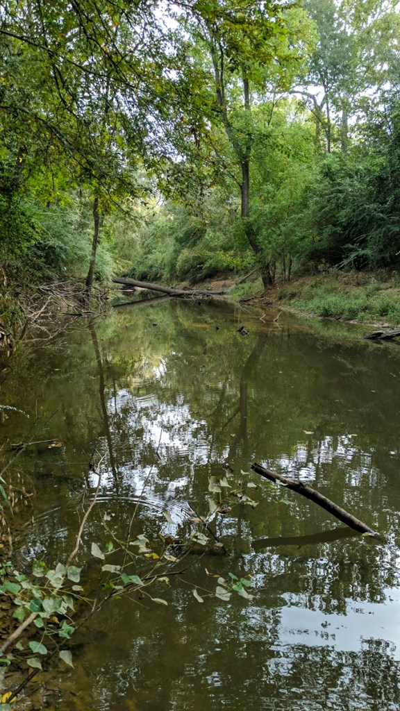
Hurricane Harvey deposited a giant sand bar at the mouth of the San Jacinto West Fork that formed a dam behind the dam. More than 3000 feet long and 3000 feet wide, it backed water up into thousands of homes and businesses. Ever since then, removing it has become a major focus of flood mitigation efforts in the Lake Houston Area.
As of this morning, virtually all of the above water portion was gone. So were there two excavators working on it last month. The portions that remain are so narrow that they are starting to crumble into the lake. The remainder of the job will likely have to be performed from pontoons. See the pictures below, all taken on 11/5/2020.
Looking downstream toward FM1960 Bridge. At the start of the current phase of dredging, the little island on the left used to fill the entire foreground and stretch from one edge of the frame to the other.As the mouth bar crumbles into the lake, workers needed railroad ties to stabilize the land long enough to get their excavator onto a pontoon.Looking upstream toward the West Lake Houston Parkway bridge. The Mouth Bar used to fill the whole area in the foreground. Contractors should finish in the next week or so at the rate they have been working. There’s perhaps 50-100 feet in length and 10 feet in width left.
What you see in the photo above is the last of an estimated 400,000 cubic yards that the City of Houston is removing.
With the above water portion of the bar removed, it will be more difficult to visualize the problem from now on. But sand bars are like ice bergs. The majority of them lurks beneath the surface. And an underwater plateau still remains. It stretches from the foreground in the photo above almost all the way to the bridge in the background.
The graph below shows what it looks like. The blue line represents the water level. The gold line represents the deepest part of the channel from where the Corps finished hydraulic dredging in September 2019 down to the FM1960 bridge.
Data compiled by RD Kissling and Tim Garfield use sonar and a 14 foot pole. The plateau stretches 3 miles. Removing the entire thing would be impossible, but a channel could be dredged through it that reconnects the river and lake.
Stephen Costello, the City’s flood czar, is working to formulate plans for the next phase of dredging and hopes to announce them this month. FEMA has said that it will pay for dredging an additional million cubic yards from the mouth bar area.
Current Spoils Going to Good Use – Expanding FM1960
Currently, the spoils are being moved upstream to Berry Madden’s property on the south side of the river, opposite River Grove Park in Kingwood. Madden has plenty of room for more. See below. He says that TxDoT will use spoils currently stored on his property to widen FM1960. That project should start in the next few days. He also says that TxDoT estimates they will use spoils at the rate that dredgers are currently bringing them to his property.
Mouth bar spoils on Berry Madden’s property between West Fork and FM1960
That should create even more room for storage on Madden’s property.
Next Dredging Targets
In addition to dredging a channel through the mouth bar, the City still needs to open up the mouths of several streams and drainage channels around Lake Houston. Rogers Gully, for instance, has formed it’s own mouth bar. See below.
Rogers Gully Mouth Bar. Photo taken July, 2020.
The City also needs somehow to address the dramatic growth of an East Fork San Jacinto Mouth Bar that grew 4,000 feet during Imelda.
Looking north at East Fork Mouth Bar south of East End Park. The blue water tower in the background is on Kingwood Drive.
Kudos to Mayor Pro Tem Dave Martin, State Representative Dan Huberty, State Senator Brandon Creighton, and U.S. Congressman Dan Crenshaw who have worked tirelessly to address these issues since Harvey.
Posted by Bob Rehak on 11/5/2020
1164 Days since Hurricane Harvey
https://i0.wp.com/reduceflooding.com/wp-content/uploads/2020/11/20201105-DJI_0072.jpg?fit=1200%2C900&ssl=19001200adminadmin2020-11-05 13:47:582020-11-05 13:55:48Three Years Later, Above-Water Portion of West Fork Mouth Bar Virtually Gone
George P. Bush, Commissioner of the Texas General Land Office (GLO), announced a 30-day extension of a deadline for renegotiating its contract with the City of Houston for a variety of Harvey Recovery Programs. The new contract would let the City keep some of the programs it had been working on while returning others to the GLO.
By tag-teaming remaining work, GLO hopes to expend all available funds before HUD pulls back unspent money out of the $1.3 billion it allocated for aid within the City.
GLO worries about the slow rate of City’s progress and whether the City can meet HUD deadlines.
The City, on the other hand, keeps insisting it is about to speed up as it falls farther behind.
When HUD attempted to pull the programs away from the City, the City filed a lawsuit to prevent that. At stake: millions in management fees for the City and hundreds of millions in aid for Harvey victims.
Last month, Mayor Pro Tem Dave Martin hinted that changes could be in the wind, but refused to release details until HUD and the GLO approved them.
Homeowners Worry About Cloud Over Programs
Meanwhile the cloud hanging over the programs worries thousands of homeowners who:
Qualified for aid but were not invited to submit an application
Have not been notified of their application’s status
Can’t get phone calls or emails returned from the City.
As of November 3, 2020, the City reports $776 million in available funds not yet committed for projects.
Three years after Harvey, the City reports it has issued only 82 reimbursement checks to homeowners for a total of $1.4 million. Either that number has not changed or the City has not updated it since October 23rd when I last posted on this subject. Neither has City updated the number of applications in its “pipeline” since August 31, 2020.
The GLO/CoH contract extension will let both sides work out a new plan that doesn’t leave disaster victims in limbo.
Statement from GLO Commissioner Bush
Commissioner Bush said: “The GLO has preliminarily agreed on the framework of an agreement with the City of Houston in the effort to help Houstonians recover from the worst natural disaster in our state’s history. The GLO has agreed to extend the current deadline for termination of the existing contract to better facilitate completion of this new agreement.”
Bush added, “The GLO’s focus continues to be making significant progress in putting federal dollars to work for the people of Houston. The GLO remains committed to helping Houston residents who are still in need of assistance with repair or reconstruction as well as moving other programs forward to successful completion within HUD’s mandatory timeline.”
GLO Still Taking Applications for Homeowner Assistance Program
In the meantime, the GLO will continue to operate the Homeowner Assistance Program to rebuild single family homes for Houston homeowners still needing assistance related to damage from Hurricane Harvey. Houston homeowners with a remaining Hurricane Harvey Housing need may find more information and apply at recovery.texas.gov/hap/houston.
Photo by Camille Pagel. Her children helped gut the kitchen instead of going to school after the Harvey flood.
GLO established the site above to help Harvey victims who have not yet submitted applications. Those who previously submitted applications which have become lost in space should call the numbers listed on the GLO site to determine their best course of action.
Note: the extension above affects contract negotiations between the City and GLO. It does not affect program deadlines.
Full Text of Interim Operations Agreement Between City, GLO
https://i0.wp.com/reduceflooding.com/wp-content/uploads/2020/01/Camille-Pagel-1.jpg?fit=800%2C1067&ssl=11067800adminadmin2020-11-04 17:58:102020-11-04 18:31:00GLO, City of Houston Agree to 30-Day Extension While They Work Out New Contract for Harvey Relief
The case of Emil C. Shebelbon, II v. Upstream Holdings, LLC ET AL (Montgomery County Cause No. 15-10-10710) provides fascinating new insights into how sand mines can affect flooding. This case is NOT about broken dikes, unauthorized discharges of sediment-laden water, or mines inundated by super-storms such as Hurricane Harvey. It involves the opposite of all those things. Yet it still has implications for state regulations – or lack thereof. Specifically, I’m talking about setbacks of mines from rivers, lack of best management practices, reclamation of mines after the completion of mining and monitoring of floodway development.
All of the mines around Shebelbon’s property (bottom center) lie completely within the West Fork floodway (cross-hatched area). Development in floodways should not impede flow.
Defendants in this case appear to have filled in or walled off more than 200 acres of floodway property north of Shebelbon. That should have raised eyebrows from Washington to Conroe City Hall, but didn’t.
Two sand mines north of Shebelbon occupy more than 200 acres of floodway. The one closest to I-45 has been abandoned without remediation. Mining debris still litters the site. Shebelbon’s property lies immediately to the south, across the river.
Plaintiff’s Property Did Not Fill Floodway
The plaintiff in this case, Emil Shebelbon, purchased approximately 200 acres of land on the southwest corner of the San Jacinto West Fork and I-45 North about 20 years ago. He operates a motorsports facility there with dirt tracks and jumps for cyclists. Most of his land is in the floodway at the original level. He did not bring in fill. However, he did push some dirt into mounds to create the jumps. Very little impervious cover exists. It resembles a park. If you were going to build a business in the floodway, this is one of the few you might consider. It does not obstruct floodwater.
Increase in Flood Frequency, Depth and Erosion
When Shebelbon bought his land, everything north of him was farm, ranch or forest land. Then one mine came in and another. They expanded and started building up their property or walling it off from the floodway with dikes.
Shebelbon soon started to notice an increase in the depth and frequency of floods. He also started to lose land to erosion during statistically small floods.
Allegations in Lawsuit
Shebelbon’s lawsuit alleges that:
Mines blocked half of the floodway, forcing their flood water south onto his property, a violation of state law.
Cutting the floodway width in half forced floodwaters up to 3-4 feet higher on his property.
The increased flow in a smaller area increased the velocity of floodwaters.
That increased what hydrologists call “sheer stress,” the force necessary to start erosion.
Modeling showed shear stresses increased upwards of 0.5 pounds per square foot. The hydrologists claim that’s enough to cause substantial land and bank erosion near and within the Shebelbon Property. That, in turn, widened the river, eroding Shebelbon’s property, they say. Shebelbon estimates he lost seven acres due to erosion caused by constriction of the floodway (see photos below).
The mine north of Shebelbon’s property on the San Jacinto West Fork. Shebelbon’s property is out of frame to the right, underneath the nose of the helicopter. To visualize the height of the dikes, compare activity in the red circle with the following photo.A dredging expert estimates that the height of the berm at this point is 50-60 feet based on the size of the dredge. Note: this photo and the one above were taken on April 21, 2020, more than a year after the hydrologist’s study. Dikes here are likely taller than 2018 LIDAR data in the study indicates.
Federal, state, county, and city regulations all prohibit restricting the conveyance of floodways. So how did this get permitted? That will be the subject of another post.
Court documents show that the mines deny any connection to Shebelbon’s damages. They issued simple, general denials and are fighting Shebelbon tooth and nail.
Surprising Expert Witness Testimony
Shebelbon, however, has produced hundreds of pages of expert witness testimony to support his claims. This 197-page document downloaded from the Montgomery County Clerk’s office contains the testimony of several experts. For this post, I’m focusing on Exhibit E-22: Flood Impacts from Surrounding Activities, prepared by Dr. David T. Williams and Dr. Gerald Blackler. Their testimony and credentials run from pages 19 to 101 of the PDF. (Caution: 19 mb download.)
Surprisingly, experts for the plaintiff found that the problem is most visible in smaller floods, i.e., less than 18-year floods. 100-year floods can overtop dikes and spread out. But smaller floods cannot.
Despite hundreds of posts on the relationship between sand mining and flooding, I have not previously focused on the phenomenon described by these experts. But every flood expert I talk to – at local, county and state levels – says their findings make perfect sense.
Looking west.Compare height of dikes on right with river bank on left by Shebelbon’s property.Photo 11/2/2020. Also note how little flood storage capacity is left in ponds.This abandoned sand mine virtually blocks TxDoT’s auxiliary bridge on the north side of the river (upper right).TxDoT commonly uses such auxiliary bridges to convey water in floodplains.Photo 11/2/2020.
Public-Policy Concerns Raised by Shebelbon
Shebelbon’s case has not yet gone to trial. But I see similar situations every time I get in a helicopter. Together, they raise some disturbing public-policy issues. For instance:
Do we need greater setbacks of mines from rivers? Greater setbacks would allow greater expansion of floodwaters and help protect neighboring properties.
Do we need a comprehensive set of best management practices for sand mines that cover reclamation and abandonment? Restoring the natural floodplain instead of leaving an elevated mine next to the freeway might have prevented some of Mr. Shelbelbon’s damages.
What happens when local officials turn a blind eye to those apparently violating regulations? Is there a higher authority to enforce compliance – short of expensive lawsuits?
Hopefully, the TCEQ or State Legislature can address these questions. But it won’t happen without public pressure.
I would simply ask.
Why should miners’ property rights outweigh those of a neighboring business or resident?
Food for thought as we approach the upcoming legislative session!
Posted by Bob Rehak on 11/4/2020
1163 Days after Hurricane Harvey
The thoughts expressed in this post represent opinions on matters of public concern and safety. They are protected by the First Amendment of the US Constitution and the Anti-SLAPP Statute of the Great State of Texas.
https://i0.wp.com/reduceflooding.com/wp-content/uploads/2020/11/20200421-RJR_0628.jpg?fit=1200%2C800&ssl=18001200adminadmin2020-11-03 22:42:522020-11-04 10:58:45Expert Witnesses Model Surprising Flood Risks in Sand Mine Lawsuit
At the October 27, 2020 Harris County Commissioners Court meeting, Precinct 2 Commissioner Adrian Garcia introduced a motion from the floor to explore using flood bond funds for maintenance projects. The motion was not on the agenda, nor did he circulate it before the meeting. It caught some commissioners off guard. Minor changes in wording between what the motion said, and how Garcia and Commissioner Rodney Ellis described it, will keep court watchers guessing about their true intent.
Harris County Precinct 2 Commissioner Adrian Garcia
In the end, the motion passed. It didn’t commit commissioners to anything more than conducting a survey and exploring options. However, last Tuesday’s discussion gives voters a peak over the horizon. It reveals what commissioners think and how desperate some are to find new sources of revenue rather than reign in runaway spending.
Garcia Explains Rationale for Motion
View the discussion yourself online.Click on Departments (Part 4 of 5). Start at approximately 4:21 into that segment. Below is a close transcription.
Adrian Garcia: The flood control district has developed the future operations and maintenance needs for the projects that the district will be constructing using the bond program. The overall need for the next 10 years is ninety seven million, with an average annual budget increase need of approximately 10 million per year. Major infrastructure that the control district owned and maintained are detention ponds, earthen channels, concrete channels, and outfall. It’s extremely important that the county funds the proactive maintenance and deferred maintenance for all Harris County owned infrastructure.
I see the spreadsheet that the district has submitted for their 10-year, cost-increase projections for bond projects and growth only as of 10/16 of this year. I am curious as to why some of the heavy equipment, the vehicles, management software implementation, the customer service, the (garbled) software, large repair projects, why these couldn’t be paid out of the bond funding [Emphasis Added, see below] versus using general-fund dollars?
And so I’d like to propose a motion that would touch on the customer-service satisfaction aspect of the flood control district. (Interruption) …
…so the customer-service satisfaction model, the risk-based model and the deferred-maintenance model.
Garcia Proposes Motion
Adrian Garcia: And so my proposed motions would read that Harris County flood control district should perform a customer satisfaction survey for deferred maintenance and services to develop the maintenance cycle and overall maintenance budget needs.
The flood control district should develop an overall condition assessment for the infrastructure and based on the risk of failure and risk of potential flooding, the flood control district should develop a prioritized criteria and maintenance-needs budget and the Harris county flood control district needs to take a comprehensive look at the condition of all existing infrastructure and identify maintenance needs that have been deferred for years due to budgetary or any other reason. There are many areas where repair work can be significantly large and may also qualify for a capital project. And the Budget Management Department needs to evaluate if we can fund this through a bond program [Emphasis Added, see below].
So that’s the motion I’d like to propose.
Judge, just make sure that we’re not forgetting how to maybe better deal with the O&M (operations and maintenance) side of the Flood Control District’s operations.
Ellis Wants Maintenance Tied to “Equity” Scheme
Rodney Ellis: Second. It also brings to my mind the question of, “How much of the flood bond money was spent before we adopted the equity guidelines?”
Harris County Precinct One Commissioner Rodney Ellis
Matt Zeve (Deputy Exec Director, HCFCD): Yes, sir, Commissioner. My staff and I are working on getting those numbers over to you by the end of the week, plus all the other questions that you asked us to dig into. We plan to have that over to you before the end of the week.
Rodney Ellis: And Commissioner (Garcia), I only ask because it relates to the issue. Let’s say if a half a billion, five hundred million was spent before we adopted equity guidelines, I know the city is trying to get us to do some swap. They don’t have equity guidelines as it relates to that … some other project in another county … and I’m going to propose that they give us a recommendation or I’ll come up with one so that we make up a project that will fund it in the absence of equity guidelines, possibly in an equitable way. And money was taken off the top while we were coming up with guidelines, and I want to compensate for that going forward. And that ties in with what you’re doing today.
Hidalgo: So there’s a motion and a second…
Cagle Objects Because Motion Isn’t in Writing
Cagle: Was it sent around, Judge? (Meaning, “Was the motion circulated so that commissioners could see in writing what they were voting for?”)
Adrian Garcia: It’s coming around now, Commissioner.
Cagle: I’ll hold off until I see it.
Hidalgo: We can circle back (before taking a vote).
One Hour Later, Motion Passes
Approximately an hour later, at time code 5:23:50, Hidalgo finally circles back to Garcia’s motion.
Commissioner Jack Cagle asks Commissioner Garcia if he discussed his motion with the leaders of the flood control district. Answer: “Some of it.”
Cagle then states, “It’s asking for an assessment. I don’t have an issue with that.”
Commissioner Radack asks whether it could be implemented without coming back to court.
Robert Soard, speaking for the County Attorney’s office, says that any action on the survey would have to come back through Commissioner’s Court for a vote.
Garcia restates the motion, but this time the wording differs slightly: To direct the Harris County Flood Control District to perform a customer satisfaction survey for deferred maintenance and services (i.e. mowing, desilting, etc.) to develop the maintenance cycle and overall maintenance budget needs, to develop an overall condition assessment for the Infrastructure and based on the risk of failure and risk of potential flooding, HCFCD should develop a prioritization criteria and maintenance needs budget and to take a comprehensive look at the condition of all existing infrastructure and identify maintenance need that has been deferred for years due to budgetary or any other reason. There are many areas where repair work can be significantly large that may also qualify for a Capital Project and Budget Management Department need to evaluate if we can fund these through a Bond Program.
Under Texas law, bond funds from the 2018 referendum can only be used for purposes approved by the voters.
However, as Commissioner Garcia alludes to in the final sentence of his motion, some maintenance projects are so large that they could legitimately be characterized as capital projects. In fact, the 2018 Flood Bond contained three such projects:
F-53 $40 million for “Rehabilitation of Channels Upstream of Addicks Reservoir to Restore Channel Conveyance Capacity”
F-52 $20 million for “Rehabilitation of Approximately 20 Miles of Channels Upstream of Barker Reservoir to Restore Channel Conveyance Capacity”
CI-012 $60 million for “Major Maintenance of Cypress Creek and Tributaries”
Before the 2018 Bond Election, Harris County Flood Control had only a $120 million budget for maintenance, half of which it spent on capital projects. So you can see that those three maintenance projects would have consumed the entire annual maintenance budget by themselves. Clearly, they fall into a gray area.
The three projects above fall under language in the flood bond that allows “channel improvements.” Also HCFCD publicized them as potential projects before the vote.
Is It Wise to Pay for Maintenance With Bond Money?
Ordinarily, it’s a bad idea to pay for maintenance out of 30-year bond funds.
Mr. Garcia’s introduction of the motion mentioned things not in the motion. For instance:
Vehicles
Software
Customer service
The County should never, in my opinion, pay for those with a 30-year bond. Neither should the bond pay for mowing, which WAS in the motion.
It’s literally like taking out a mortgage to cut your grass. A week later, you’re back where you started and saddled with 30 years of debt.
A New Bond?
Above, I bolded “THE BOND” and “A BOND.” At first, Commissioner Garcia said he wanted to use money from THE BOND (meaning the 2018) bond to pay for some maintenance items. But his actual motion refers to “A BOND.”
That’s certainly a strange way to refer to the historic flood bond passed in 2018. It sounds as though he’s laying the groundwork to float another flood bond.
Rodney Ellis’ rush to second the motion supports the second interpretation. For months, Ellis has consistently carped that there won’t be enough money in the 2018 bond to do all the projects that need doing.
Ellis, Equity Flap and Elm Grove
That’s why Commissioner Ellis redefined “equity” earlier this year. The 2018 Flood Bond specified “equitable distribution of funds.” 88% of people throughout the county voted for that language – thinking they would get their fair share of flood bond money. However, Commissioner Ellis redefined the word to favor the socially vulnerable and penalize others.
Now, Ellis seems to be linking help for Elm Grove to the City of Houston’s adoption of “equity guidelines” comparable to his. He said, “I’m going to propose that they give us a recommendation or I’ll come up with one…” Then he added, “That (meaning equity) ties into what we’re doing here today.” Literally, they are conducting an inventory of maintenance needs and developing a prioritization framework for it.
That framework will no doubt be used to ensure distribution of maintenance dollars according to Mr. Ellis’ definition of equity.
Posted by Bob Rehak on 11/3/2020
1162 Days since Hurricane Harvey
https://i0.wp.com/reduceflooding.com/wp-content/uploads/2020/11/Garcia.jpg?fit=764%2C586&ssl=1586764adminadmin2020-11-02 23:10:042020-11-03 09:25:39Harris County Commissioners Vote to Explore Using Flood-Bond for Maintenance, Possibly Floating Another Bond
The Monday 10am update from the National Hurricane Center (NHC) on Hurricane Eta now predicts the storm will slam Central America then re-emerge into the Caribbean over the Bay of Honduras in the NW Caribbean.
Beyond 96 hours (Saturday), it’s uncertain what the storm will do.
NHC Predicts Cat 4
Eta has become an impressive November hurricane as it continues to undergo rapid strengthening. Low vertical wind shear and warm sea surface temperatures ahead of Eta are expected to allow for continued rapid strengthening during the next 12 to 24 hours. The updated NHC = forecast now calls for Eta to become a category 4 hurricane before it nears the coast of Nicaragua. After landfall, Eta should quickly weaken while it moves over the mountainous terrain of Central America.
Although Eta’s low-level center may not survive after being inland over Central America for so long, most of the global models depict a cyclone over the northwestern Caribbean Sea later this week and into the weekend which appears to develop from at least a part of Eta’s remnants, and the new NHC track forecast shows the system emerging over the northwest Caribbean Sea after 96 h.
However, the uncertainty in the long-range portion of the forecast remains quite high.
Key Messages
Eta is forecast to strengthen to a major hurricane very soon, and additional strengthening is likely before it reaches the northeastern coast of Nicaragua on Tuesday. Catastrophic wind damage is expected where Etas eyewall moves onshore, and preparations should be rushed to completion within the Hurricane Warning area.
Through Friday evening, heavy rainfall from Eta will likely lead to catastrophic, life-threatening flash flooding and river flooding across portions of Central America, along with landslides in areas of higher terrain. Flash and river flooding is also possible across Jamaica, southeast Mexico, El Salvador, southern Haiti, and the Cayman Islands.
A potentially catastrophic and life-threatening storm surge, along with battering waves, is expected along portions of the northeastern coast of Nicaragua near and to the north of where the center makes landfall. Water levels could reach as high as 12 to 18 feet above normal tide levels in some parts of the hurricane warning area. Preparations to protect life and property should be rushed to completion.
Posted by Bob Rehak on 11/2/2020
1161 Days since Hurricane Harvey
00adminadmin2020-11-02 09:16:282020-11-02 09:16:34Hurricane Eta Now Predicted to Re-emerge over NW Caribbean
Tropical storm formed in the central Caribbean Sea late yesterday and tied a record going back 170 years.
28th Storm of Year
Eta became the 28th tropical storm of the 2020 hurricane season and tied 2005 for the most tropical storms in an Atlantic hurricane season since records began in 1851.
Satellite images show the system still lacks any defined inner core.
Tropical Storm Eta formed late yesterday in the central Caribbean.
“Eta is a fairly large system,” says Harris County Meteorologist Jeff Lindner, “and such systems generally take time to consolidate and develop. Eta is moving westward and this motion is expected to continue for the next 72 hours.”
Hurricane Threat to Nicaragua and Honduras Tuesday
On its current track, Eta should slam into Nicaragua and Honduras Tuesday morning. The National Hurricane Center (NHC) predicts Eta will intensify into a hurricane on Monday. NHC also predicts heavy rainfall and flash flooding through Thursday, with landslides in higher elevations.
Fading High-Pressure Ridge Creates High Uncertainty Beyond 72 Hours
Eta is under the influence of a high-pressure ridge that extends from the Atlantic Ocean to near Cuba, which is forcing the system toward the west. After landfall, the system should significantly slow down as the high pressure ridge begins to weaken. “The main question,” says Lindner, “will there be enough of a defined system remaining to get pulled northward over the western Caribbean Sea and potentially the SE Gulf of Mexico. Given the expected land interaction and general slow motion beyond 72 hours, the confidence in the forecast for later this week is lower than average. Adjustments in the track are likely over the next several days.”
Intensity
“There could be a period of rapid intensification prior to Eta making landfall over central America,” adds Lindner.
The Houston Area has been extremely lucky this year. Only one storm flooded only part of the City. Just to our east, Louisiana endured direct impacts from five storms.
Posted by Bob Rehak on 11/1/2020 based on info from HCFCD and NHC
1160 Days since Hurricane Harvey
https://i0.wp.com/reduceflooding.com/wp-content/uploads/2020/11/1000x1000.jpg?fit=1000%2C1000&ssl=110001000adminadmin2020-11-01 13:12:442020-11-01 13:12:48It’s Official; 2020 Ties Record For Most Tropical Events in Recorded History
Often, I post about sand mines or developments that encroach on floodplains and floodways to the detriment of people downstream. But when I learned of this story, it made me extremely happy. The Bayou Land Conservancy (BLC) announced last week that Joe Swinbank and Don Poarch, partners at Sprint Sand & Clay, have donated 117 acres of unspoiled wetlands to the organization. The land borders Spring Creek in Tomball, north of Lone Star College and Harris County Precinct 4’s Spring Creek Park. It will have a significant impact on conservation, according to the BLC.
Natural wetlands on the tract donated to BLC by Swinbank and Poarch. This and all photos below are courtesy of the Bayou Land Conservancy.
“We are excited to own this ecologically rich nature preserve that will help us connect the community to the benefits of land conservation”, said BLC board chair Lisa Lin. “This donation will benefit the community for many generations, and be an enduring legacy of the incredible generosity of Mr. Swinbank and Mr. Poarch.”
Spring Creek meanders along the property’s southern border.
Ecologically rich wetlands such as these help retain water during floods, reducing the impact on downstream residents.
Land Originally Purchased for Mining
“As the greater Houston area continues to grow at a rapid pace, striking a healthy balance between land preservation and land development has never been more important as we seek to protect the many economic and community benefits we all enjoy,” Swinbank said. “The Bayou Land Conservancy’s extensive network of preserved trails and waterways just minutes from Houston is impressive in its form and function—a model of what can be achieved when community stakeholders work together. We’re proud to partner with the Conservancy to continue these important environmental efforts and extend BLC’s preserved trails and waterways west into the Tomball area.”
Don Poarch echoed his partner’s sentiments in acknowledging the award. “We’re grateful for the recognition as this year’s Conservation Champions and happy to continue to champion the BLC and its important mission to preserve these lands for natural flood control, cleaner water and wildlife protection,” Poarch said. “On behalf of our entire team at Sprint Sand & Clay, Joe and I hope this land along Spring Creek enhances the community with protected green space while providing beautiful trails and waterways for people to reconnect with nature and each other.”
Family History Led to Donation
Beyond the positive environmental and community impact, the land in Tomball has personal significance to Swinbank and his family. “My wife was raised in the area, and her extended family has deep roots in Tomball and Rosehill going back to the area’s original German settlers,” Swinbank added. “My family and I couldn’t be happier that the Conservancy will ensure this land is preserved and protected for generations to come.”
Location of new preserve
Online Gala to Honor Conservationists Nov. 13
BLC will honor Swinbank and Poarch at its annual Annual Land Lover Gala as Conservation Champions. The Gala will be held virtually this year from 6-7 pm on Friday, November 13th. More information about the event can be found here. Wildlife film maker Ben Masters will be the keynote speaker. Mark your calendar.
No-Cost Gala Great Way to Learn More About BLC
Because of COVID, BLC’s net proceeds will likely be down this year. There’s no cost to attend the virtual event. “We’d just like to encourage people to join us,” said Jill Boullion, Executive Director of the BLC.
On a personal note, I will say this. The Bayou Land Conservancy and its committed staff stand tall among many worthy conservation groups in the Lake Houston Area. Their cooperative strategy is simple.
They put conservation easements on environmentally important land that is bought or donated so that it serves its natural function. They make a huge difference and deserve everyone’s support.
Bayou Land Conservancy protects land along streams for flood control, clean water, and wildlife. BLC is a nationally accredited, community-sponsored land preservation organization working to permanently protect land, with a focus on the streams that feed Lake Houston, an important source of drinking water for millions in the region. More information is available at: www.bayouland.org.
Posted by Bob Rehak on 10/31/2020
1159 Days since Hurricane Harvey
https://i0.wp.com/reduceflooding.com/wp-content/uploads/2020/10/20190627-Poarch-Swinbank-22-2019-6-27.jpg?fit=1200%2C900&ssl=19001200adminadmin2020-10-31 14:30:112020-10-31 20:53:56Sand Miners Donate 117 Acres of Unspoiled Wetlands Along Spring Creek to Bayou Land Conservancy
Today, October 30, 5:00 p.m. is the deadline to send testimony to the Texas House of Representatives Interim Committee on Aggregate Production Operations (APOs). The committee is looking into production practices of sand mines and other types of APOs across Texas.
If you haven’t yet submitted comments, please take time to put something together—even if it’s just a few paragraphs!
Write about how YOU personally have been or will be impacted by sand mines. Pick one or two of these key issues that will most affect you personally:
???? Air quality ???? Water quality, use and availability ???? Surface and ground water contamination and flooding ???? Rapid development of APOs without adequate regulatory oversight, mine planning, or reclamation ???? Truck traffic ???? Nuisance issues: blasting, noise, odor, visible blight ???? Economic impacts, devaluation of property
How to Submit Comments
When you are ready to submit your testimony, email it to jeff.frazier_hc@house.texas.gov (jeff DOT frazier UNDERSCORE hc) or press the link below. Make sure to include:
Your name
Address
Phone number
Testimony in attachment (PDF preferred, Word Document OK, preferably five pages or less)
Sand mining is necessary to make concrete and support growth. No one wants to put sand miners out of business. People do, however, have legitimate issues with egregious sand-mining practices.
They want sand produced in a manner that respects public safety, health, homes, and the environment.
Since starting this website I have created more than 200 posts about problems with the way sand mining is actually practiced in the Houston Area, and how dangerous practices contribute to flooding. To learn more, use the search phrase “sand mines” or see the index page. Here are some examples.
Sand mining in floodways on West ForkDischarging industrial waste water into the public drinking water supplyAnother discharge of industrial wastewater into the headwaters of Lake HoustonFailure to stabilize soil or restore land to alternative us after abandonment of mine.Mining too close to natural gas pipeline and exposing itEndangering five pipelines carrying highly volatile liquids near the West Fork San JacintoWest Fork sand dune deposited during Harvey downstream from 20-square miles of mines in floodway. It contributed to the flooding of more than 7,000 structures.River mining without a permitFlooding adjacent property with floodwaterBarely plugged breach near LMI mine on West ForkPumping wastewater into wetlands
Don’t tolerate sand-mining practices that jeopardize your home, family and community. Write today.
Posted by Bob Rehak on 10/30/2020
1158 Days since Hurricane Harvey
The thoughts expressed in this post represent opinions on matters of public concern and safety. They are protected by the First Amendment of the US Constitution and the Anti-SLAPP Statute of the Great State of Texas.
https://i0.wp.com/reduceflooding.com/wp-content/uploads/2020/05/20191104-RJR_4147.jpg?fit=1200%2C800&ssl=18001200adminadmin2020-10-30 14:58:542020-10-30 15:23:05Submitted Your Sand Mine Testimony Yet?
A year after the Texas Commission on Environmental Quality (TCEQ) filed a notice of enforcement against a Plum Grove sand miner named Somaiah Kurre, it appears that Kurre still has not complied with TCEQ regulations to restore his abandoned mine. However, he has found time to take over operations at the troubled Triple PG Sand Mine in Porter. The Texas Attorney General is already suing the Porter mine. This raises two serious public policy issues.
Should miners who leave behind environmental issues at one site be allowed to operate another before fixing problems at the first?
Permits Without Performance
It also calls into question state regulations that allow sand mines to obtain operating permits without forcing them to restore mines to nature or alternative uses when done.
Performance bonds are common in the construction industry.
Texas should adopt a performance-bond policy. This case shows why.
Texas regulations state only that a mine needs a reclamation plan to get a permit. However, there are no regulations stating they must execute the plan.
When unscrupulous operators are done mining a site, there’s no reason for them to invest another penny in it.
Texas needs performance bonds and/or a “toxic legacy” law. Companies that abandon unsafe mines should be forbidden to operate anywhere else in the state. They just can’t be trusted.
Troubled History In Plum Grove
Texas Concrete Sand and Gravel, Inc., one of Mr. Kurre’s 16 companies, has a troubled history at its Plum Grove location. Before October 2019, TCEQ investigated it nine times for 17 alleged violations in four years. Twelve involved unauthorized discharges of industrial waste.
Previous alleged violations included failure to:
Prevent unauthorized discharge of industrial waste (7 investigations plus 5 complaints)
Renew registration
Document steps taken to address benchmark exceedances
Comply with record keeping and reporting requirements
Maintain compliance with permitted numeric effluent limitations
Sample water quality at designated outfalls.
Abandoned Without Compliance After Imelda
During Tropical Storm Imelda in September 2019, the mine’s dikes breached in four places. The mine discharged industrial wastewater and sediment into the San Jacinto East Fork. The East Fork empties into Lake Houston, the source of drinking water for 2 million Houstonians.
The company eventually fixed the breaches, but cancelled its Multisector General Permit (MSGP) and Aggregate Production Operation (APO) registration.
A company spokesperson told TCEQ investigators that the company had ceased all operations at the site.
No visible attempt has yet been made to stabilize soil, restore the land that needed it, or convert the site to an alternative use. So the company is still violating terms of its permit.
An excavator, dredge, shed, other abandoned equipment, plus bacteria- and scum-laden ponds remain. See photos below.
Photos Taken 10/25/2020
Abandoned stockpile shows signs of recent activity. After a year with supposedly no activity, you would think some of this water would have clarified. Can you spot the five different colors of water in different ponds?Dredge has not moved in months.Working parts of dredge are crusted with rust.Large part of site not stabilized. Tracks show trucks entering and leaving the mine, taking sand from the mine’s stockpile.But no signs or permits are posted at the site.
“The MSGP contains requirements … to terminate permit coverage after mining activity has ceased. The operator must demonstrate they have accomplished the final stabilization requirements: 1) completion of soil disturbing activities, 2) stabilization to minimize soil erosion, 3) ensuring stormwater runoff does not contribute to a violation of water quality standards, and 4) the site has been revegetated or left in the condition consistent with post-mining land use such as a nature park or lakes.”
“When operators have achieved final stabilization, they must submit a Notice of Termination which has been signed and certified by the responsible signatory authority as described in 30 TAC §305.44,” said the spokesperson.
The TCEQ spokesperson also said that Kurre, who fancies himself a startup impresario, is trying to negotiate payment terms for a $19,036 fine that TCEQ levied against him on April 14, 2020.
The First Amended Petition in the Triple PG lawsuit by the Attorney General shows that Kurre took over operations at the Triple PG mine in April. However, the amended petition did not specify who the new operator was at the time.
Ironically some of the alleged violations that the TCEQ charged Mr. Kurre with in Plum Grove are identical to the charges that the Attorney General lodged against the Triple PG mine in Porter.
The Many Faces of Somaiah Kurre
A search for corporate listings associated with Kurre’s name in the Texas Secretary of State database shows that he controls – wholly or partially – 16 businesses.
Manjari Enterprises LLC
Texas Concrete Enterprise, L.L.C.
Asam LLC
Texas Concrete Enterprise – II, LLC
Shree Radha, LLC
Texas Concrete Enterprise – IV, L.L.C.
Texas Concrete Sand and Gravel, Inc.
Plum Grove Material, Inc.
Rohini Enterprises Inc.
JSR Materials, Inc.
Bright Star Stores, Inc.
US Readymix Inc.
US Fracsand, LLC
Rama Krishna 2, LLC
Texas Frac Sand Materials, Inc.
Texas Concrete Sand and Gravel Enterprise, Inc.
Along the East Fork, Kurre owns or operates mines in San Jacinto, Liberty, Montgomery and Harris Counties. That possibly qualifies him as the largest operator on the East Fork.
Toxic Legacy?
Note unusual blue-green color in pond – a likely indicator of potentially dangerous bacteria.
According to the TCEQ, the color of that blue-green pool on the right in the photo above indicates that it is likely filled with cyanobacteria. Cyanobacteria can produce cyanotoxins.And the CDC says that cyanotoxins are “among the most powerful natural poisons known. They can make people, their pets, and other animals sick. Unfortunately, there are no remedies to counteract the effects.”
Pond near entry road.Not quite a nature park! Texas Concrete’s legacy in Plum Grove. No identifying signs or permits are posted at the entrance to the site, despite the truck traffic.
Sites like this can unnaturally accelerate the buildup of sediment dams in rivers. Not only do they expose sand, they expose it in the floodways of rivers and streams. After Imelda, a huge sand bar set up at the mouth of the San Jacinto East Fork . It contributed to flooding of nearby residents. The public will have to pay to remove it.
East Fork Mouth Bar after Imelda. Before Imelda, this area was 18 feet deep. Boaters say the deepest part of the channel is now three feet.
Posted by Bob Rehak on 10/29/2020
1157 Days after Hurricane Harvey and 405 since Imelda
The thoughts expressed in this post represent opinions on matters of public concern and safety. They are protected by the First Amendment of the US Constitution and the Anti-SLAPP Statute of the Great State of Texas.
https://i0.wp.com/reduceflooding.com/wp-content/uploads/2020/10/20201025-DJI_0966.jpg?fit=1200%2C900&ssl=19001200adminadmin2020-10-29 22:04:442020-10-30 12:52:27Sand Miner Takes Over Troubled Porter Mine While Still Violating TCEQ Regs at Plum Grove Mine
Flood mitigation is a complex process with hundreds of moving parts, all dependent on each other. When you focus intensely on the pieces, periodically it helps to review how they fit together. Only when you do this can you see progress toward your goals. In that spirit, I created this presentation. It has a Kingwood slant, but really addresses the whole Lake Houston Area. Everything connects.
What Caused Flooding
First, let’s look at what caused the flooding during Harvey and other recent storms…apart from record rainfalls.
The rain fell on a landscape that was ill-prepared the handle it.
Look at flooding like a process engineer. There’s always a bottleneck in the system somewhere between the sky and Galveston Bay. Both local and regional issues contributed to the magnitude of the Harvey and Imelda disasters.
Underestimating Rainfall Meant Underpreparing
When we built communities, such as Kingwood, we underestimated the amount of rainfall we could get. After four so-called 500 year rains in five years, we’re now working with higher rainfall precipitation frequency estimates (called Atlas 14). For this area, the 100-year rain is about 30-40% higher than the previous standard. That means floodplains will soon expand when new flood maps are released. Some people in the 500-year floodplain will find themselves in the 100-year. And people in the 100-year may find themselves in the floodway of rivers and streams. Unless we do something.
Lake Conroe Release Coincided with Downstream Peaks
On top of record rainfalls, during Harvey, the SJRA released water from Lake Conroe at a time that coincided with downstream peaks from other tributaries. The release by itself would have created the ninth largest flood in West Fork history. It comprised about one third of all the water coming down the West Fork.
Population Growth in MoCo
On top of that, Montgomery County has seen tremendous population growth in the last decade. Conroe was the fastest growing city in America in 2017 and is still #6. The county itself is the second fastest growing in the region.
To pave the way for all that development, we’ve seen a huge increase in sand mining upstream in the last 25 years. Before 2011, unregistered, bootleg operators went unregulated. But even those who are registered don’t follow common-sense regulations common in other states, which protect the environment and downstream residents. For instance, they mine so close to the river that dikes frequently fail. As a result, they have contributed to a greater than than natural buildup of sediment in our rivers. After Harvey, the US Army Corps of Engineers found that the West Fork was 90% blocked just downstream from River Grove Park.
Another factor contributing to flooding: Lake Conroe can release water 15 times faster than Lake Houston. That makes it difficult to lower lake levels in advance of a major storm. Storms have a nasty habit of veering away at the last minute. The small gates on Lake Houston mean you have to start lowering the lake far in advance. That raises the risk of wasting precious water. Larger gates would make managing lake levels easier.
Ditches, Streams Filling In
Finally, sediment built up in more places than the San Jacinto. It has also built up in the ditches and streams that lead to the river. This reduces convenance within neighborhoods. There’s less room to store water in streams, so it backs up into storm sewers and streets, and can eventually flood homes.
But what can we do to remedy the damage already done? Leaders in the Lake Houston Area identified a four-part strategy and are working with the SJRA, City of Houston, Montgomery County and Harris County Flood Control to implement it. Elements include:
Increasing upstream detention to reduce the volume of water coming downstream during floods
Dredging the river to remove sediment dams that back water up
Increasing the number of gates on the Lake Houston Spillway to release water faster
Restoring or expanding ditches to handle more water
Let’s look at each of those in a little more detail.
Upstream Detention
The Humble/Kingwood area sits at the tip of a funnel. 535 square miles in a seven-county region drain into Lake Houston.
The San Jacinto River Basin Master Drainage Study identified 16 potential detention projects to hold water back during major storms. However, they would cost roughly $3 billion to reduce damage by less than $1 billion. So that’s a stretch. FEMA evaluates projects based on their benefit/cost ratio.
The SJRA has already applied for a grant for a detention project on Caney Creek which empties into the east fork. But we also need something that can help offset releases from the Lake Conroe Dam on the West Fork. Next step: figure out the funding piece of the puzzle.
The slide below shows why we need additional dredging.
An 18-foot high underwater plateau exists between where the Army Corps stopped dredging on the West Fork and the FM1960 Bridge where scouring during Harvey reduced the channel depth.
The chart above shows the deepest part of the channel between those two areas. If left in place, this plateau will force flood water out of banks during floods. It will also trap sediment, negating the value of previous dredging efforts.
More Gates for Lake Houston
FEMA has conditionally approved up to approximately $50 million to increase the outflow capacity of Lake Houston. During Havey, the flow of water over the spillway was estimated at 11-13 feet. That’s reportedly higher than the flow over Niagra Falls.
In Kingwood, they identified nine projects and recommended two for immediate implementation that should improve drainage on a third tributary, Ben’s Branch.
Recommendations include expanding:
Kingwood Diversion Ditch to take water out of the Ben’s Branch watershed and also improve drainage from surrounding subdivisions from Woodland Hills down to the West Fork.
Taylor Gully – if a deal cannot be reached to purchase Woodridge Village and build a regional detention basin on it.
In addition, Flood Control and the City are looking at minor improvements to other ditches that back water up in places, for instance, at culverts under Kingwood Drive.
Goal: Restore 100-Year Level of Service
Engineers solving all these problems have a goal: to restore your home to what they call a 100-year level of service. That means if your home was built above the 100-year floodplain, it should not flood in a 100-year rain – based on new Atlas 14 standards. In places, sedimentation and upstream development have reduced the level of service to 2 years over time.
We need to restore the capacity of ditches, streams, the river and lake to handle 100-year rains. So we can get water from the sky to the Bay without it going through your living room.
While progress may feel painfully slow, many improvements have already been made.
For instance, in addition to dredging, Flood Control has divided Ben’s Branch up into five projects. Three are already complete:
You can help by remaining engaged. Without public pressure, it’s easy for elected officials to ignore these problems and defer expensive solutions. Keep flood mitigation a high priority. Floods can strike at any time. We had four tropical systems barely miss us this year.
Posted by Bob Rehak on 10/27/2020
1155 Days since Hurricane Harvey and 404 since Imelda
The thoughts expressed in this post represent opinions on matters of public concern and safety. They are protected by the First Amendment of the US Constitution and the Anti-SLAPP Statute of the Great State of Texas.