The Bayou Land Conservancy (BLC) preserves land along streams for flood control, clean water, and wildlife.
Bayou Land Conservancy Achievements
With the support of individuals and corporations, BLC now protects 14,000 acres at 60 preserves in the Houston region. They focus on 4,000 square miles which includes the Lake Houston Watershed. And they log thousands of volunteer hours every year. This group stands tall among the many worthy conservation groups in Houston.
If you haven’t met BLC yet, tonight you will have a chance to see what they do from the comfort of your own laptop.
https://i0.wp.com/reduceflooding.com/wp-content/uploads/2020/11/Gala.jpg?fit=1200%2C718&ssl=17181200adminadmin2020-11-13 06:44:312020-11-13 06:44:34You’re Invited: Bayou Land Conservancy Virtual Gala Tonight, Keynote Speaker Ben Masters
Welcome to Flood Notes. So much has been happening lately on the flood front, it’s hard to keep up with it all. So this post will be a digest of things that affect flooding on the local, state and national fronts.
Humble ISD North Transportation Center Construction Update
We have had ideal construction weather in the last month and contractors at HISD’s north transportation center on Ford Road in Porter had made a lot of progress. They have completed the detention pond. More than half the remaining site is covered with concrete parking lots. And it looks as if the foundation for a building has also been poured. Humble ISD anticipates shorter routes for half the district will save taxpayers $2 million per year. The District hopes to open the Center in 2021.
Humble ISD North Transportation Center 11.7 acre site. Photo taken 11/07/2020.
Colony Ridge
This massive development in Liberty County has turned into the world’s largest trailer park. The developer of Colony Ridge keeps expanding at a record clip. Perhaps he’s anticipating a sales boom when the Grand Parkway creates better access. At the moment, he appears to be cutting and burning another 3000 acres. Nearby Plum Grove residents have complained about the smoke.
Colony Ridge expansion. Photo taken 11/1/2020.Colony Ridge expansion. Photo taken 11/1/2020.Colony Ridge expansion. Photo taken 11/1/2020 after a long period without rain. Notice the wet areas covered up with fill. Wetlands once criss-crossed this area.
Chlorine Creek
Plum Grove residents who live next to Colony Ridge also report the strong smell of sewage and chlorine coming from a new sewage treatment facility along Maple Branch a quarter to a half mile away. TCEQ fined the company that provides these services not long ago for the illegal discharge of 48,000 gallons of raw sewage into the same creek from a lift station.
Sewage treatment plant creating strong odors for Plum Grove residents as well as those in Colony Ridge itself.Wastewater from this plant is apparently discharged into Maple Branch just inside the tree line at the top of the frame.The discharged water has a heavy chlorine smell to it. All life in the creek seems to have died according to residents. That includes, fish, tadpoles, minnows, etc.
Michael Shrader, a Plum Grove resident who lives adjacent to Maple Branch, has affectionately renamed it Chlorine Creek.
HUD Approves New GLO Plans for Disaster Funding
On 11/4, Texas Land Commissioner George P. Bush announced that the US Department of Housing and Urban Development (HUD) approved two state action plans detailing the distribution and eligible uses of more than $285 million. The Community Development Block Grant Disaster Recovery (CDBG-DR) funds will assist in long-term recovery efforts following severe flooding in 2018 and 2019 in South and Southeast Texas. To view the action plans, please visit recovery.texas.gov/action-plans. To expedite the recovery process, the GLO will directly administer and oversee the funds.
TWDB Accepting FEMA Flood Mitigation Assistance Grant Requests
This one affects government officials in Cities, Counties, Special Districts, etc.. FEMA’s Flood Mitigation Assistance (FMA) grant program provides federal funding to help communities pay for cost-effective ways to reduce or eliminate the long-term risk of flood damage to flood prone structures that are insured under the National Flood Insurance Program. FMA program funds can be used for planning and projects. The deadline to apply to the Texas Water Development Board is December 1, 2020. For more information, please visit www.twdb.texas.gov/flood/grant/fma.asp.
FEMA Program Helps Enforce Building Codes, Floodplain Management
FEMA announced the release of a policy to provide communities with resources to enforce building codes and floodplain management following a major disaster declaration. The “Building Code and Floodplain Management Administration and Enforcement” policy can provide funding for the first 180 days following a major declaration for:
Costs associated with extra hires or contracted support
Reviewing and processing building permits and occupancy and compliance certificates
Conducting building inspections and initial substantial damage field surveys
Reviewing disaster-related development in the floodplain
Providing educational services to the public on floodplain requirements.
The policy is a result of the Disaster Recovery Reform Act of 2018, Section 1206. This policy applies to all major disaster declarations declared on or after August 1, 2017.
CBS aired a chilling story tonight about the floods brought by Hurricane Eta. The storm dumped up to 7 inches of rain on the Carolinas. It washed out roads and bridges. In fact, a reporter was standing on one bridge when pieces of it started to fall into the raging floodwater. Very dramatic footage if you missed it.
Eta nearly tied Gordon for the longest hurricane on record. Jeff Lindner, Harris County Meteorologist, says that had the storm lasted until tomorrow, it would have taken the longevity record.
Posted by Bob Rehak on 11/12/2020
1171 Days since Hurricane Harvey
The thoughts expressed in this post represent opinions on matters of public concern and safety. They are protected by the First Amendment of the US Constitution and the Anti-SLAPP Statute of the Great State of Texas.
https://i0.wp.com/reduceflooding.com/wp-content/uploads/2020/11/20201101-DJI_0009.jpg?fit=1200%2C900&ssl=19001200adminadmin2020-11-12 20:28:362020-11-12 20:29:28Flood Notes: Highlights of Current Happenings
Yesterday, the TCEQ held a virtual hearing on sand-mine best management practices (BMPs). After listening to stakeholders on all sides of the issue, TCEQ agreed to allow public comment for another 30 days before making any recommendations to TCEQ commissioners.
Breakdown of Five-Hour Meeting
Yesterday’s hearing started with a description of the TCEQ rule-making process and timetable. The meeting then compared two sets of BMPs – one submitted by the Texas Aggregate and Concrete Association (TACA) and the other submitted by the Lake Houston Area Flood Prevention Initiative.
The good news: both sides agreed on most BMPs.
The bad news: Substantial disagreement remains on several crucial BMPs as well as the area(s) that the BMPs will apply to.
The TCEQ then allowed three stakeholders (Texans for Responsible Aggregate Mining [TRAM], the Bayou Land Conservancy and ReduceFlooding.com) to make presentations.
After lunch, the meeting resumed for two hours of discussion about the BMPs.
At the end of the meeting, everyone agreed to extend the public comment period from 15 days to 30, given the importance of the effort and Thanksgiving.
No decisions were made at yesterday’s meeting. The objective was purely to give all interested stakeholders a chance to express their opinions.
Disagreement over Where BMPs Will Apply
TACA wanted the BMPs to apply only to the main stems of the East and West Forks of the San Jacinto. The Flood Prevention Initiative wanted them to apply to the tributaries of the East and West Forks also. In other words, the entire watershed upstream of Lake Houston.
The area of enforcement proposed by the Flood Prevention Initiative includes everything upstream of the Lake Houston Dam. However, TACA wants to exclude tributariesof the East and West forks.
Areas of Disagreement
Overall, the two sides disagreed on 12 of 41 BMPs. Of the twelve, the Flood Prevention Initiative and ReduceFlooding.com identified three as crucial.
Minimum setbacks from rivers
Performance bonds ensuring reclamation at the end of mining
Whether compliance with BMPs should be voluntary or mandatory
For more information on the three crucial BMPs mentioned above, see this presentation or read below.
ReduceFlooding.com Presentation
I started my presentation by pointing out that the San Jacinto provides:
A source of sand for a few dozen companies
Water for 2 million people
Modern life would be impossible without concrete. But surviving for even a few days without clean water would be even more impossible. We must strike a balance to protect both industry and people.
Since Harvey, I have rented helicopters almost every month and taken approximately 17,500 photos of sand mines.
I’ve never claimed that sand mining was the only source of sedimentation in the river. But it is a large contributor in my opinion.
After Harvey, huge blockages showed up in the San Jacinto, such as the one below east of River Grove Park. The Army Corps found the river was 90% blocked in this area. Before they dredged it, the park flooded six times in three months on minor rains.
However, I had no success in getting TACA to adopt them. Nevertheless, Bill McCabe and Dave Feille of the Lake Houston Area Flood Prevention initiative took up the challenge. Thanks to them, we are where we are today.
We have reached substantial agreement, but the sides remain far apart on three crucial measures.
The three remaining areas of substantial disagreement
The remainder of the presentation focuses on these issues.
Need for Greater Setbacks
Texas has no minimum setbacks for mines from rivers.
TCEQ
Other states specify minimum setbacks of varying widths.This images shows the Texas Concrete Mine in Plum Grove on the East Fork and how the floodway (cross-hatched area) covers most of the mine.
This mine’s dikes breached in four places during Harvey and again during Imelda. Residents downstream described a sudden wave of water coming down on them as if a dam had broken.
The West Fork has far more mines. Between I-45 and I-69, a 20-mile distance, we have twenty square miles of sand mines, virtually all of them wholly or partially in the floodway. That makes the average width of the river one mile. And that increases the potential for erosion 33X.
One of several breaches at the Triple PG mine that remained open for months in 2019.
Floodwaters sweeping through mines are not the only source of sediment downstream. A mine’s dikes can also constrict floods as you see in the images below. This image shows a mine just west of I-45 and the West Fork.
Details from the red circle in the bottom image are shown in the close-up image above it. This mine walled off half the floodway with a dike approximately 50 feet high.
In all but the largest floods, such high dikes concentrate floodwater on the opposite side of the river above. That, in turn, increased velocity of water, accelerated erosion, and cost the businessman on the opposite shore more than seven acres of his property in ten years. Because floodwater had half the space to spread out, he floods more frequently and higher.
Regardless of the mechanism of erosion, the increased rate of sedimentation due to sand mining, has contributed to the buildup of sediment dams like the West Fork mouth bar (photographed above two weeks after Harvey). Such dams behind the dam contributed to flooding thousands of homes and businesses. They also are costing taxpayers hundreds of millions of dollars to remove.
Greater setbacks could have easily avoided much of this expense. Sand miners are passing their cleanup costs along to the public.
Greater setbacks would help reduce flooding. They could also help improve water quality.
The photo above shows the upstream limit of Lake Houston. The water elevation at the I-69 bridge normally matches the water elevation at the Lake Houston dam. So this IS our drinking water you’re looking at. Removing all this sludge before it reaches your tap is a large part of your water bill every month. Greater setbacks from the river could have prevented this catastrophe as well.
Performance Bonds for Reclamation
In Texas, miners need to file a reclamation plan before they start mining. But when they are done, nothing obligates them to execute the plan.
Many miners can and do walk away from mines. A performance bond filed before they start mining would ensure that money for cleanup when they were done. If they rehabilitated the property, they would get the money back. But if they did NOT, taxpayers would not have to foot the bill or leave dangerous eyesores in their midst.
At a minimum, miners should revegetate disturbed areas to reduce the potential for erosion and sedimentation. Shown above, the Texas Concrete Plum Grove Plant after the operator walked away from it more than a year ago. No attempt has yet been made at restoration, although TCEQ is pursuing them.Shown above: (top l to r) Abandoned dredge, concrete crushing facility at abandoned mine, abandoned equipment. Bottom Left: abandoned pipe.
Need for Mandatory, not Voluntary Best Practices
TACA would like best practices to be voluntary. Can you imagine the state of the U.S. Treasury if the IRS considered paying taxes optional?
Shown above: an abandoned sand pit on North Houston Avenue in Humble. This pit has no fencing or berms around the perimeter like it should. Worse, the steep-sided slopes break off in slabs. Erosion now threaten adjacent businesses and roadways. West Fork mine contaminated with cyanobacteria. Cyanotoxins, sometimes formed by the bacteria, are the most potent in nature according to the CDC. CDC also says there is no known cure. I caught this mine pumping bacteria-laden water into wetlands. Mines that do not comply with regs put those that do comply at a competitive disadvantage.Complying with safety regulations should not be optional.
The lower image shows five pipelines carrying highly volatile liquids at a West Fork mine. Headward erosion exposed them, too, when LMI mined too closely. The giant pipelines sagged like clotheslines across a 100-foot gap.
Conclusion
The six images below show the confluence of the West Fork and Spring Creek near I-69. I took them from different angles during different months, but they all show the same thing: sediment coming from the West Fork where a heavy concentration of sand mines exists. If miners voluntarily complied with best management practices, these photos would have looked far different.
West Fork from different angles is the siltier in each case.
If you comment, make sure you explain why you feel the way you do. Don’t just say “I like X or Y.” Give your reasons. Cite your experience. That will help the TCEQ formulate regulations that make a difference.
Posted by Bob Rehak on 11/11/2020
1170 Days since Hurricane Harvey and 419 since Imelda
The thoughts expressed in this post represent opinions on matters of public concern and safety. They are protected by the First Amendment of the US Constitution and the Anti-SLAPP Statute of the Great State of Texas.
https://i0.wp.com/reduceflooding.com/wp-content/uploads/2020/11/Rehak-TCEQ_Page_20.jpg?fit=2000%2C1125&ssl=111252000adminadmin2020-11-11 19:20:452020-11-11 19:56:43TCEQ Accepting Public Comment on Sand Mine Practices for 30 Days
Members of the public may access the meeting via webcast by following this link: https://www.gotomeeting.com/webinar/join-webinar and entering Webinar ID 603-908-859. It is recommended that you join the webinar and register for the meeting at least 15 minutes before the meeting begins. You will be given the option to use your computer audio or to use your phone for participating in the webinar.
The West Fork was 90% blocked at this point according to the TCEQ. That contributed to the flooding of more than 600 homes.
For those persons without computer or internet access who would like to participate in the meeting, call 844-368-7161 and enter collaboration code 435007#.
If you are unable to attend the Virtual Meeting; the meeting information, summary, and updates will be posted on the above webpage.
Background:
The petitions were filed by the Texas Aggregates and Concrete Association (TACA) and the Lake Houston Area Grassroots Flood Prevention Initiative (LHAGFPI). The petitioners requested that the commission adopt a new rule under the Watershed Protection Rules that would establish best management practices for commercial sand mining and other lawful purposes within the San Jacinto River Watershed in Montgomery, Liberty, and Harris counties.
On August 12, 2020, the commission considered the petitions and directed staff to initiate the rulemaking process and include stakeholder involvement. Through the stakeholder process, the TCEQ will determine the appropriate best management practices that are technically supported for the sand mining industry to control pollutants within stormwater discharges. The rulemaking will define specific areas within the watershed that will be regulated and add a new chapter within the 30 TAC, Chapter 311 Watershed Protection Rules.
The original petitions for rulemaking are posted on the TCEQ website at the following links:
https://i0.wp.com/reduceflooding.com/wp-content/uploads/2020/11/West-Fork-Sandbar.jpg?fit=1200%2C800&ssl=18001200adminadmin2020-11-10 09:13:252020-11-10 09:17:46TCEQ Meeting on Sand Mine Best Practices Today from 9:30 to 3 CDT
After killing more than 100 people in Central America, Eta made landfall across the Florida Keys overnight and has now moved west into the SE Gulf of Mexico. Numerous curved bands continue to rotate into southern Florida where more than 13 inches of rainfall has been recorded. Eta is the 12 landfalling tropical system on the US coast this season…the previous record was 9 in 1916.
This morning’s satellite image shows the eye of Eta visible in yesterday’s images has collapsed.
Meanwhile, two more storms are brewing in the Atlantic. One is heading away from land. The other, which has a 50% chance of formation in the next five days is moving into the central Caribbean.
Discussion of Eta
Eta’s made landfall on the middle Florida Keys late yesterday evening and has continued westward across Florida Bay and is now over the SE Gulf of Mexico. Eta has maintained well-defined circulation. The wind field has also expanded with tropical storm force winds extending well away from the center and well north along the Florida coast.
The official forecast from the NHC takes Eta toward north Florida, but much divergence remains among the models.
ETA’s Track
Eta will move west to WSW for the next 24 hours, then meander over the SE/E Gulf of Mexico into the middle of the week. The storm could stall over the warm waters of the Gulf loop current. But by later this week, a strong upper-level trough should turn Eta north and then northeast back toward Florida. However, forecast models vary widely. Confidence is low regarding the track forecast. Large changes remain possible. Little consensus exists between weather models.
The South Florida Water Management District shows even less consensus.
Eta’s Intensity
Even though Eta is moving over warm waters, wind sheer and surrounding dry air should keep it in check. The official forecast brings Eta to a minimal hurricane over the SE Gulf of Mexico before weakening again late in the week.
Other Storms
Two other areas of interest have developed in the Atlantic basin and 97L over the eastern Atlantic has a high chance of developing into a tropical system while the tropical wave approaching the Caribbean has a medium chance of developing later this week. The next tropical storm will break the previous record for the most tropical storms in an Atlantic hurricane season.
https://i0.wp.com/reduceflooding.com/wp-content/uploads/2020/11/29L_tracks_latest.png?fit=768%2C800&ssl=1800768adminadmin2020-11-09 11:10:152020-11-09 11:15:53Eta Slimes Florida With Foot of Rain So Far, Sets New Record, More Storms May Follow
When last I checked on the status of Perry Homes’ Woodridge Village project in Montgomery County north of Elm Grove, contractors were still putting the finishing touches on detention ponds. Since then, Perry has:
Erected chain-link fencing with barbed wire around the perimeter
Planted some grass to stabilize the soil
Removed all construction equipment from the site.
More Than a Year After Imelda, Still No Deal
Perry is waiting to see if Harris County and the City will be able to finalize a deal to purchase the site and turn it into a regional detention basin. The three sides have been talking for more than a year. The project twice contributed to flooding Elm Grove last year after Perry cleared the land but before they built all of the required detention capacity.
Now that they’re finished though, they still have only 60% of what they need. That’s because the company rushed to get the project permitted before new, higher Atlas-14 regulations went into effect.
In February this year, the City declined to consider purchasing Woodridge Village. The City said it was the County’s responsibility because voters passed a flood bond, even though the City had approved Perry’s plans even before LJA’s drainage analysis had been submitted.
In the meantime, Perry Homes hinted to Elm Grove leaders that, “It sure would be nice if all those lawsuits went away.” Perry Homes also still has a “For Sale” sign up on the property, although the listing company does not show the property on their website.
Entrance to Woodridge Village from Woodland Hills.
This all reminds me of a line from one of my favorite movies. “Once the plan gets too complex, everything can go wrong.”
Walter Sobchak in Big Lebowski
At this rate, the 60% solution may stay the 60% solution for a long time. Certainly, the lawsuits show no sign of going away any time soon. The Harris County District Clerk’s website (see CAUSE NO. 2019-33415) has seen a flurry of filings in recent months.
Current Pics
Here’s how the site looks today.
Looking east over S1 towards S2, the two detention ponds on the southern border of Woodridge Village.Looking north along the eastern border toward N3, the third pond on the northern section.Where the northeastern portion of the site drains into the head of N3. Note security fence around perimeter.Looking south along N3 toward Taylor Gully in the background.Looking east along the northern border toward Ford Road in Porter.Looking west along the northern borderLooking southwest across the northern portion of Woodridge Village, with N3 on the left.N1, the first detention pond on the northern section of Woodridge VillageThe massive N2 pond along the southwestern border of the northern section.
One of the most beautiful parts of Kingwood also helps protect the area from flooding: East End Park. If you’ve never seen it, you should. The park comprises 158 acres and contains about five miles of nature trails. With the help of boardwalks, the trails wind through wetlands that form the perimeter of the park.
Those wetlands help slow runoff during storms. And the park itself puts distance and elevation between the East Fork of the San Jacinto and the nearest homes.
Park Almost Became Another Subdivision During 1980s
The park was not always destined to become a park. Originally Friendswood Development wanted to build another subdivision where the park is now. As Friendswood cut streets in nearby Kings Point, they dumped the extra dirt in what is now the park’s giant meadow. That’s why it’s so much higher than surrounding wetlands.
These meadows comprise approximately 45 acres of tall grass, an abundant food source for migrating birds.Looking south. The East Fork San Jacinto is on the left. Sand damage from Harvey and Imelda at Eagle Point is in the foreground.Birdhouses once 10-feet up on trees are now at ankle height.Looking west from the north side of the park on the left. The East Fork (out of frame to the right) and Caney Creek converge at East End Park’s Eagle Point.Also to the right is the 5000-acre Lake Houston Nature Park.Looking south again. The East Fork on the left empties into Lake Houston in background. Trails border the river within the trees.
But in 1988, the EPA issued a cease and desist order because they were jeopardizing the wetlands. Blocked from further development, Friendswood tried to turn a problem into an amenity that could add value to homebuyers. The company donated the land to the Kingwood Service Association to own and operate as a park for the benefit of all Kingwood residents.
Development as Nature Park in 2000s
Not much happened with the park for about a decade. Then KSA, with the help of volunteer groups, like the Boy Scouts, started building a small trail network, mostly on the north side of the park.
Around 2000, KSA debated the future of the remainder of the park. Should they turn it into more sports fields? Or keep it a nature park? The nature park faction won out. And for the next fifteen years, KSA slowly built new trails and improved old ones as money became available.
Birder’s Wonderland
The Lake Houston Nature Club has documented approximately 150 species of birds in the park, some threatened or endangered. In season, birders seem everywhere. Migrating birds munch on the abundant tall grass which seems to go to seed just in time for the migration.
In the park, I’ve spotted everything from painted buntings to majestic bald eagles. In fact, part of the park is named Eagle Point because of the frequent eagle sightings there.
Healing Power of Nature
Shortly after KSA put in the Eagle Point Trail, I encountered a man sitting in the same place on the river bank day after day. I asked him what his attraction was to that particular place. He said that it helped him heal. I asked if he wanted to explain that. He said he was undergoing treatment for cancer and the the beauty gave him the will to go on living. I suspect he’s not the only one who has found sustenance in nature there.
One often sees families walking with young children there. I also suspect kids learn to translate the love they feel from parents on such walks into a lifelong love of nature.
Living Lessons
Sadly both Harvey and Imelda completely inundated the park. Eagle Point became covered with 10-15 feet of sand which killed many of the trees there and filled in some of the wetlands. Regardless, the park remains a natural gem and a living lesson about the cycles of nature.
The pictures below show some of the natural beauty. To get to the park, take Kingwood Drive east until you run out of road. You can see the park entrance from the parking lot.
East End Park poster.
Sunrise over Lake Houston from Kingwood’s East End Park at Otter Point. By Dr. Charles Campbell.
Posted by Bob Rehak on 11/8/2020
1168 Days since Hurricane Harvey and 416 since Imelda
https://i0.wp.com/reduceflooding.com/wp-content/uploads/2020/11/20201023-DJI_0896-copy.jpg?fit=1200%2C900&ssl=19001200adminadmin2020-11-07 19:26:012020-11-08 10:40:39East End Park from the Air: A Wetlands Success Story
Mayor Pro Tem Dave Martin issued a newsletter today aboutabout the Army Corps’ Coastal Protection Study. The City, he says, has worked with its civic, business, state and federal partners ever since Hurricane Ike in September 2008 on this project. “Hurricane Laura, renewed the sense of urgency with our federal partners,” said Martin. “We need collectively to identify a single path forward and focus all our energy and resources into ramping that project up and moving it forward.”
Texas Ranks as Third Most Vulnerable State to Hurricanes
The National Oceanic and Atmospheric Administration ranks Texas as the third most vulnerable state to hurricanes when ranked by property value.
Destruction on Bolivar Peninsula After Hurricane Ike. Looking south toward Gulf. Ike scoured infrastructure right out of the ground. Storm surge reached almost all the way to I-10 and swept buildings off their foundations more than 10 miles inland.Destruction on Bolivar Peninsula After Hurricane Ike. Looking north toward Bay. Nothing was left standing for miles.
Ike went right up the throat of Galveston Bay. Had the storm come in 30 miles west, the refineries from Texas City to Deer Park, Pasadena and Baytown could have looked like the photos above. That would have been an environmental disaster of the highest order.
Corps Releases Coastal Protection Study, Seeks Public Comment
The Corps will hold six, virtual, public meetings for comments. Each will require registration to participate. They will hold the first of the virtual public meetings on Monday, November 16, 2020 from 11am to 1pm.
Interested participants who cannot make the meetings, can submit comments by emailing coastaltexas@usace.army.mil. All comments must be postmarked by December 14, 2020. Written comments can be mailed to:
USACE, Galveston District
Attention: Mr. Jeff Pinsky
Environmental Compliance Branch Regional
Planning and Environmental Center
Post Office Box 1229
Galveston, Texas 77553-1229
“It is my hope,” said Martin, “that all our local representatives will submit letters of support during this comment period to the Army Corps of Engineers. Once they have expressed support for the Coastal Texas Study, local officials should work with their federal counterparts to ensure the study is approved and subsequent projects authorized once they reach Congress. That should be early in 2021.”
Martin Describes Approval Gauntlet
“At the State level, we have an excellent state sponsor for the plan in the General Land Office (GLO). The GLO serves as the local advocate for coastal communities and the state-level partner with the USACE,” says Martin “In January, the Texas State Legislature will be continuing its work towards getting a workable plan approved for our protection.”
Martin added that at the Federal level, we now have a comprehensive surge protection plan moving through the USACE approval process. This plan provides an estimated $2 of benefits for every $1 spent. That ratio makes the proposed barrier system competitive as a national priority for Congressional approval and funding, claims Martin.
Specifically, the Legislature will be looking at advancing different funding strategies for our barrier system, including using Resilience Bonds to capture value through avoided losses. These large infrastructure projects take many years to design, develop, and construct. But we are closer now than ever to having a workable solution for our region, says Martin. “The prize is at hand, and we mustn’t allow ourselves to get distracted!”
“Our local business and civic leaders must stay focused, vigilant, and engaged in the process to inform themselves of the opportunities we have,” says Martin. “They must also help educate other Houstonians on the ways we can protect our communities to make the Houston an even more desirable place to live and work.”
Where To Find the Study and Some Key Conclusions
Here’s a link to the executive summary of the proposal. Significantly, the plan is no longer a monolithic dike stretching along the entire coastline. It contains both natural and man-made elements. USACE has abandoned the plan of building a wall along SH87 that stretches from Bolivar Flats to High Island. That was dropped from the plan to minimize both social and environmental impacts. Instead, the Bolivar and Galveston beach and dune systems will be increased in size to reduce storm surge impacts.
That area is one of the richest wildlife areas in the state. Millions of birds migrate to the coastal marshes there every year. They depend on the wetlands to fish and nest.
Tens of thousands of geese take to the wing at Anahuac National Wildlife Refuge after Hurricane Ike.Proud new parents
The Corps’ Coastal Protection Study lays out a plan to restore degraded ecosystems to create natural buffers that protect communities and industry on the Texas coast from erosion, subsidence, and storm losses. It includes approximately 114 miles of breakwaters, 15 miles of bird rookery islands, 2,000 acres of marsh, 12 miles of oyster reef, and almost 20 miles of beach and dune.
The plan varies by coastal region and takes in everything between Beaumont and Brownsville.
The total cost: $26 billion. But it would reduce flood damaged structures by 77% in a 1% (100-year) event, and save an estimated $2.25 billion per year during the 50-year life of the project.
If authorized and funded by Congress, subsequent phases of the project would include preliminary engineering and design; construction; and operations and maintenance. Completion of preliminary engineering and construction of the Recommended Plan would depend on Congressional approval and funding. USACE believes the recommended plan could be designed and then constructed within 12 to 20 years.
Meeting Dates, Must Register First
The Corps will hold the six meetings on:
Monday, November 16, 2020 from 11:00AM to 1:00PM and from 6:00PM to 8:00PM
Thursday, December 3, 2020 from 11:00AM to 1:00PM and from 6:00PM to 8:00PM
Tuesday, December 8, 2020 from 11:00AM to 1:00PM and from 6:00PM to 8:00PM
Posted by Bob Rehak on 11/7/2020
1166 Days since Hurricane Harvey
https://i0.wp.com/reduceflooding.com/wp-content/uploads/2020/11/Hurricane-Ike-358.jpg?fit=1500%2C998&ssl=19981500adminadmin2020-11-06 22:48:562020-11-06 23:09:08Army Corps to Hold Virtual Public Meetings on Coastal Protection Study
A pregnant woman in pain being carried to safety in waist deep water.
Families carrying crying babies on shoulders and hips.
Dazed elderly women and men.
Bewildered pets.
Streets and homes flooded in waist deep water.
People stranded on rooftops.
Rescue boats without motors struggling against currents.
Evacuees carrying belongings in plastic bags and baskets to higher ground.
The rescued, sleeping in pup tents.
Food Supply Jeopardized
Food supply is a real concern according to aid workers. “The country’s road network is badly damaged, airports were closed and much of the Sula valley, the country’s most agriculturally productive, was flooded,” said the story.
Sanitation will be a real issue, too. People are already struggling with Covid.
Landslides Bury Towns
In Guatemala, a landslide in the central part of the country hit the town of San Cristobal Verapaz, burying homes and leaving at least 25 dead. At least another 50 people were missing in two more slides. And government rescue teams had not yet reached the sites.
The impacts of Eta will be as far-reaching and long lasting as Harvey’s. But the people in Central America have far fewer resources to help them recover.
The International Monetary Fund lists the gross domestic product per capita of Honduras at $6,068 dollars. Nicaragua is even less – $5,681.
Please help if you can through your favorite relief organization.
Posted by Bob Rehak on 11/6/2020 based on an AP story
1165 Days since Hurricane Harvey
https://i0.wp.com/reduceflooding.com/wp-content/uploads/2020/11/Screen-Shot-2020-11-06-at-1.11.01-PM.jpg?fit=1200%2C757&ssl=17571200adminadmin2020-11-06 13:22:552020-11-06 13:33:49Eta Kills At Least 57 in Central America
The 3PM CST update from the National Hurricane Center (NHC) on Eta shows the storm emerging into the Bay of Honduras this afternoon as a tropical depression. Then it will intensify into a tropical storm, head to Cuba, and take a left turn into the Gulf. Round and round she goes, where she stops…
Jeff Lindner, Harris County Meteorologist says, “It is possible that Eta may eventually transition toward a sub-tropical system as it becomes increasingly entangled with the upper level trough over the Gulf of Mexico. For now NHC brings the system to a 65mph tropical storm over the Florida straits early next week with some of the intensity guidance showing slightly stronger solutions that would be near hurricane intensity.”
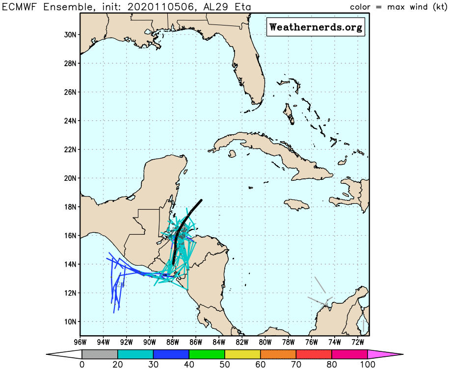
As of this morning, as this WeatherNerds spaghetti model shows, forecasts were all over the place. Later forecasts suggest it may be pushed east of the Houston Region. But again, it’s still a long way off.
So keep your eye on the Gulf. As Yogi Berra used to say, “It ain’t over till it’s over.” What goes for baseball goes for hurricane season – this year especially! Remember, Eta set a record for intensifying from a tropical storm into a major hurricane within hours before slamming into Nicaragua.
Posted by Bob Rehak on 11/5/2020based on info from the NHC, WeatherNerds and HCFCD.
1164 Days since Hurricane Harvey
https://i0.wp.com/reduceflooding.com/wp-content/uploads/2020/11/211147_5day_cone_no_line_and_wind.png?fit=897%2C736&ssl=1736897adminadmin2020-11-05 16:48:082020-11-05 16:58:46If You Thought Hurricane Season Was Over, Think Again